Participatory Understanding of Groundwater Dynamics: Threats and Responsive Management [Энэтхэг]
- Шинийг нээх:
- Шинэчлэх:
- Эмхэтгэгч: Pratik Ramteke
- Хянан тохиолдуулагч: –
- Хянагчид: Rima Mekdaschi Studer, William Critchley
CDVI 3D Model
approaches_7555 - Энэтхэг
Бүлгүүдийг үзэх
Бүгдийг дэлгэх Бүгдийг хаах1. Ерөнхий мэдээлэл
1.2 Арга барилыг баримтжуулах болон үнэлгээ хийхэд оролцсон хүн эсвэл байгууллагын холбоо барих хаяг
Газар ашиглагч:
Yadav Ankita
ankita.yadav@wotr.org.in
Watershed Organisation Trust (WOTR), Pune
Энэтхэг
Газар ашиглагч:
Ghodake Navnath
navnath.ghodake@wotr.org.in
Watershed Organisation Trust (WOTR), Pune
Энэтхэг
1.3 WOCAT-аар баримтжуулсан өгөгдлийг ашиглахтай холбоотой нөхцөл
Мэдээллийг хэзээ (газар дээр нь) цуглуулсан бэ?
30/04/2021
Эмхэтгэгч болон гол мэдээлэгч хүн(хүмүүс) WOCAT аргачлалаар баримтжуулсан мэдээллийг ашиглахтай холбоотой нөхцлийг хүлээн зөвшөөрсөн:
Тийм
2. ГТМ Арга барилын тодорхойлолт
2.1 Арга барилын товч тодорхойлолт
CoDriVE-VI is a participatory approach that integrates local knowledge with scientific data through 3D visual modelling to assess groundwater vulnerability and support sustainable, community-based groundwater management. It overlays surface and subsurface features, enabling villagers to visualize aquifer systems and develop informed water use plans.
2.2 Арга барилын дэлгэрэнгүй тодорхойлолт
Арга барилын дэлгэрэнгүй тодорхойлолт:
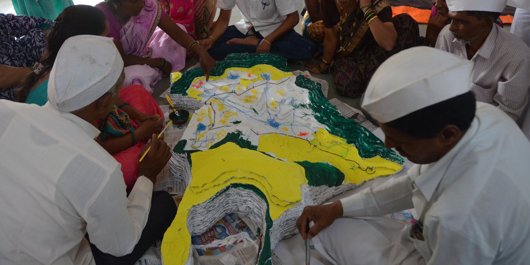
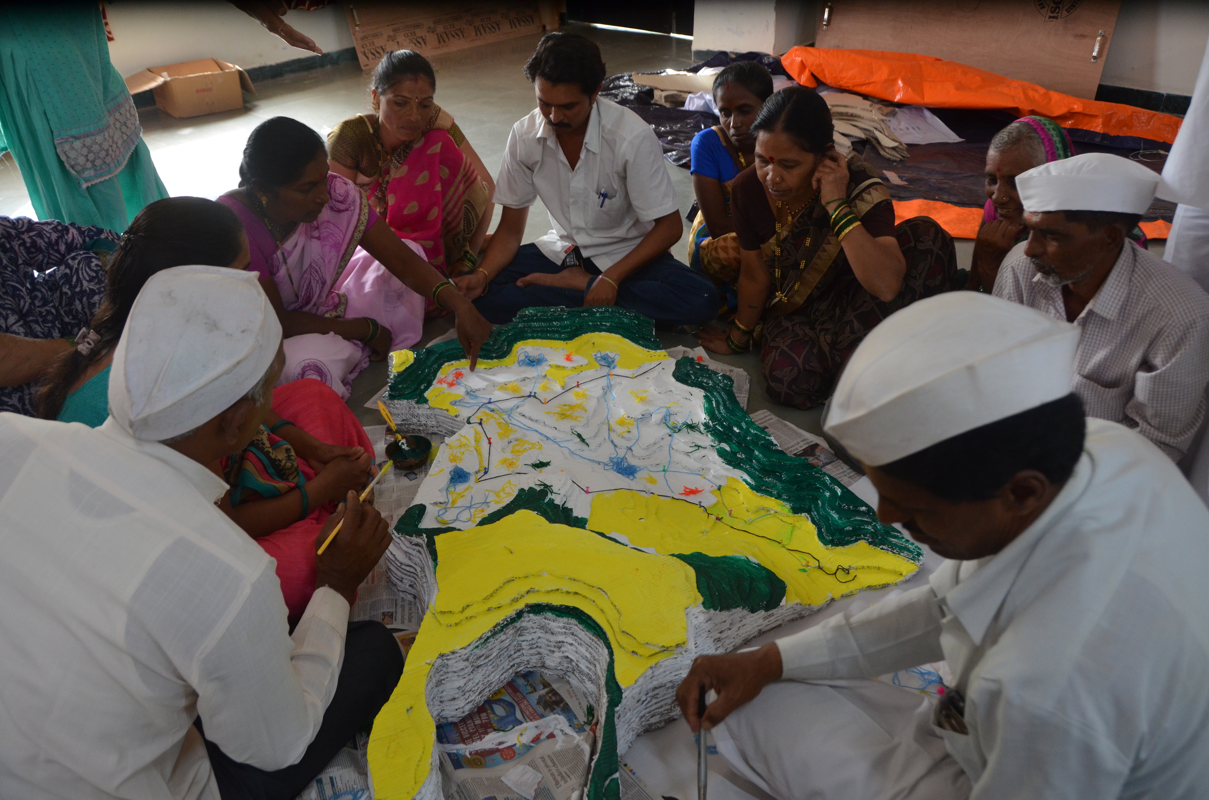
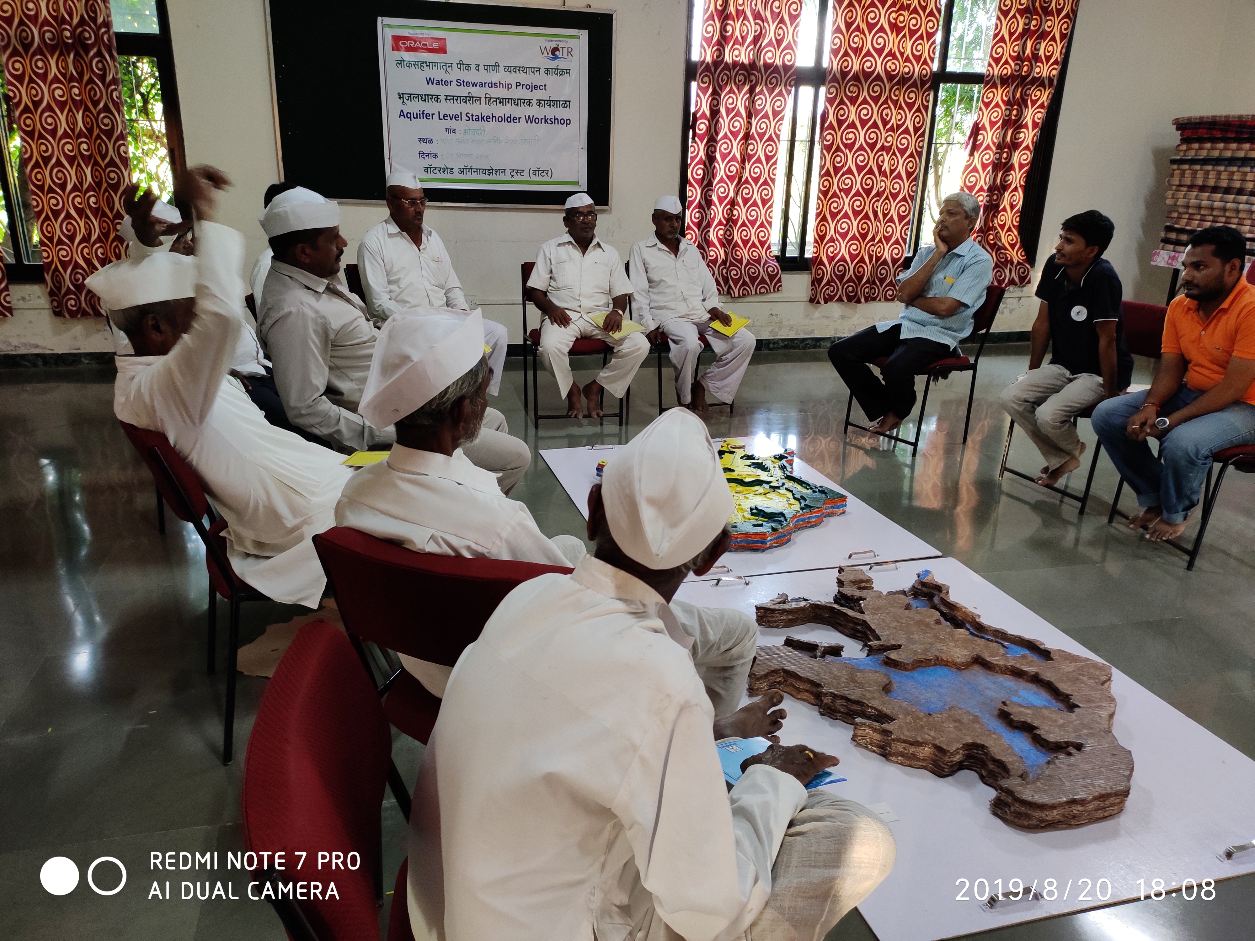
CoDriVE-VI (Community-driven Vulnerability Evaluation – Visual Integrator) is a participatory approach developed by the Watershed Organisation Trust (WOTR) to support sustainable groundwater management. It aims to demystify the invisible subsurface and make aquifer systems understandable to rural communities by combining scientific tools with local knowledge in a hands-on, visual format. While the process is facilitated by WOTR, communities are placed at the center of the process, contributing traditional insights, assisting with data collection, and actively participating in constructing and interpreting the 3D model. Thus, the approach is best described as participatory, with strong elements of community ownership and engagement.
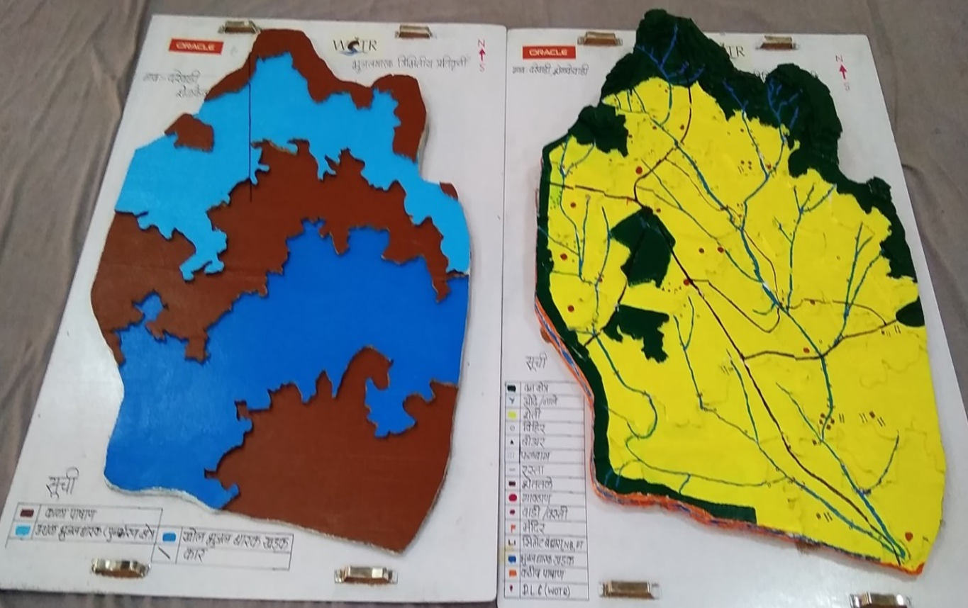
The “Visual Integrator” refers to the integration of both surface and subsurface data—such as topography, drainage, geology, well inventory details, and geophysical survey results—into a tangible, scaled three-dimensional model. This participatory 3D modelling (P3DM) process helps communities visualize how aquifers relate to the landscape, showing key features such as recharge zones, discharge points, and areas of intensive groundwater extraction.
“Vulnerability evaluation” is carried out through the community’s participatory analysis of the model. Using the integrated visual platform, villagers can identify zones that are more vulnerable to depletion—such as those with low recharge, high borewell density, or historically declining water tables. While a formal vulnerability matrix is not used, the 3D model serves as a practical vulnerability map. It guides discussions and decisions around water budgeting, aquifer recharge, crop-water planning, and the development of informal rules for responsible groundwater use.
The methodology combines participatory rural appraisal with hydrogeological and geospatial techniques. After an initial orientation and trust-building phase, communities help map surface features. Subsurface data is then collected through geological mapping, well inventory surveys, and geophysical methods like Vertical Electrical Sounding (VES). The data are analyzed using GIS tools and inverse slope modelling. The 3D model is then constructed using layered cardboard sheets, with communities contributing throughout the process—cutting, assembling, painting, and validating the layers.
The CoDriVE-VI process unfolds in several stages: community mobilization and planning; surface and subsurface data collection; model building in participatory workshops; and result interpretation and management planning. Key stakeholders include community members, WOTR facilitators, technical experts (geologists and GIS specialists), and local governance representatives.
Participants found the visual models highly effective in helping them grasp aquifer dynamics, leading to a shift in perception—from seeing groundwater as an individual entitlement to recognizing it as a shared resource. This in turn fostered collective decision-making. The approach has also contributed to improved groundwater literacy, informed water budgeting, and motivated some villages to initiate local groundwater governance practices.
While climate change is a key driver of groundwater stress, the approach also acknowledges other socio-economic and environmental pressures—such as population growth, land-use change, deforestation, and the uncontrolled proliferation of borewells—as critical factors influencing groundwater vulnerability. By visualizing these interconnections, CoDriVE-VI supports more holistic and sustainable groundwater management at the community level.
2.3 Арга барилын зурагууд
Медиа галерей
2.5 Арга барил нэвтрүүлсэн улс орон / бүс нутаг / байршил
Улс:
Энэтхэг
Улс/аймаг/сум:
Maharashtra
Байршлын дэлгэрэнгүй тодорхойлолт:
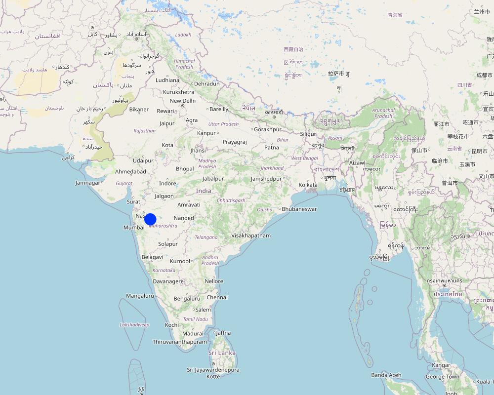
Darewadi,Post. Kauthe Malkapur Tal. Sangamner, Dist. Ahilyanagar, Maharashtra
Map
×2.6 Арга барилыг эхлэх, дуусах огноо
Эхлэх жилийг тэмдэглэ:
2017
Тайлбар:
The tool was developed based on experiences from multiple village-level implementations in Maharashtra. The approach is ongoing.
2.8 Арга барилын үндсэн зорилго, зорилтууд
1. To build the capacity of rural communities to understand groundwater systems, including aquifer behavior and climate and non-climate stressors affecting groundwater availability.
2. To make subsurface aquifer characteristics visible and comprehensible through participatory 3D modelling that integrates scientific and local knowledge.
3. To foster collective ownership and sustainable management of groundwater as a shared, finite resource.
4. To support community-led evaluation of groundwater vulnerability and guide responsive actions such as water budgeting and recharge planning.
5. To document, preserve, and apply indigenous spatial knowledge related to land use, topography, and local water systems.
6. To enable informed decision-making by facilitating the transfer of community-generated insights to local governance bodies and development agencies.
2.9 Арга барилын хүрээнд хэрэгжсэн Технологи/Технологиудад дэмжсэн эсвэл саад учруулсан нөхцлүүд
нийгэм / соёл / шашны хэм хэмжээ, үнэт зүйлс
- Идэвхижүүлэх
The participatory nature of CoDriVE aligns well with community-based traditions and values. Villagers appreciated visual models and collective dialogue.
санхүүгийн нөөц, үйлчилгээний хүртээмж / боломж
- Хазаарлалт
Physical model preparation and technical surveys (like geophysical VES) require resources. Financial constraints can limit replication or scaling.
Бүтэц зохион байгуулалт
- Идэвхижүүлэх
Support from institutions like WOTR and local governance structures helped facilitate workshops and technical assessments.
талуудыг хамтын ажиллагаа/зохицуулалт
- Идэвхижүүлэх
Strong collaboration between communities, facilitators, technical experts, and local leaders enabled smooth implementation
Хууль, эрхзүйн хүрээ (газар эзэмшил, газар, ус ашиглах эрх)
- Хазаарлалт
Customary laws viewing groundwater as private property can hinder the recognition of aquifers as shared resources.
Бодлогууд
- Идэвхижүүлэх
National and state-level programs like Atal Bhujal Yojana and Maharashtra Groundwater Act 2009 support aquifer-based planning and groundwater literacy.
Газрын засаглал (шийдвэр гаргах, хэрэгжүүлэх, шаардлага)
- Идэвхижүүлэх
Local institutions and village-level bodies were engaged in discussions and planning.
ГТМ-ийн талаарх мэдлэг, техникийн дэмжлэг авах боломж
- Идэвхижүүлэх
Technical support from WOTR and use of local knowledge supported learning and capacity building
зах зээл (материал худалдан авах, бүтээгдэхүүн борлуулах), үнэ
- Идэвхижүүлэх
ажлын багтаамж, хүн хүчний нөөц бололцоо
- Идэвхижүүлэх
Community enthusiasm and involvement were high during workshops and model building.
- Хазаарлалт
Manual preparation of 3D models requires time and coordination, which may be demanding in some villages.
Бусад
- Идэвхижүүлэх
Visual and tactile tools helped bridge the knowledge gap between experts and villagers.
- Хазаарлалт
Initial complexity of scientific terms (e.g., aquifer, resistivity) required careful facilitation and adaptation
3. Оролцогч талуудын оролцоо ба үүргүүд
3.1 Арга барилд оролцогч талууд болон тэдгээрийн үүргүүд
- Орон нутгийн газар ашиглагч / орон нутгийн иргэд
Villagers and farmers from Ahilyanagar and Jalna districts, Maharashtra
They participated actively in the mapping exercises, provided indigenous knowledge on topography and land use, contributed to well inventory and aquifer-related insights, and were directly involved in building the 3D models. Their engagement was central in interpreting subsurface information and applying it to groundwater planning.
- олон нийтэд түшиглэсэн байгууллагууд
Village Water Management Committees, Water Stewardship groups
Helped mobilize community members, facilitated communication between villagers and technical teams, and supported local-level planning and rule-setting for groundwater use.
- ГТМ-ийн мэргэжилтэн/ хөдөө аж ахуйн зөвлөх
WOTR technical staff and hydrogeology facilitators
Provided scientific inputs on geology and hydrogeology, conducted well and geophysical surveys, interpreted data, supported the construction of groundwater potential maps, and trained community members in groundwater management
- Судлаачид
Researchers and field investigators from WOTR and contributing institutions
Developed the methodology, documented experiences, synthesised scientific and community knowledge, and analysed feedback for continuous improvement of the tool.
- ТББ
Watershed Organisation Trust (WOTR)
Lead agency responsible for conceptualizing, facilitating, implementing, and documenting the approach. Conducted workshops, managed technical assessments, trained field teams, and engaged communities.
- Хувийн хэвшил
HSBC Software Development India (as supporter)
Provided financial support for printing and disseminating the CoDriVE-VI manual.
- Орон нутгийн захиргаа
Gram Panchayat members, Sarpanches
Participated in workshops, helped validate maps and data, encouraged community participation, and supported local rule-making for sustainable groundwater use.
- Засгийн газар (шийдвэр гаргагч, төлөвлөгч)
Indirectly linked via supportive policies (e.g., Atal Bhujal Yojana, National Aquifer Management Project (NAQUIM))
Although not directly involved in implementation, national policies provided support for the overall context and justification of aquifer-based participatory planning and water budgeting.
- Олон улсын байгууллага
ProSoil project (GIZ)
Supported in publishing and promoting the CoDriVE-VI manual, including showcasing it at UNCCD COP14
Хэрэв хэд хэдэн оролцогч талууд оролцсон бол голлох төлөөлөгчийг зааж өгнө үү:
Watershed Organisation Trust (WOTR)
3.2 Арга барилын янз бүрийн үе шатанд орон нутгийн газар ашиглагчид / бүлэглэлүүдийг татан оролцуулах
| Орон нутгийн газар ашиглагч / орон нутгийн иргэдийн оролцоо | Хэн оролцсоныг тодорхойлж, үйл ажиллагааг тайлбарлана уу | |
|---|---|---|
| санаачлага/идэвхжүүлэлт | интерактив | Local villagers in the project areas (e.g., Ahilyanagar and Jalna districts) were engaged early through orientation sessions. While the initiative was introduced by WOTR, community members showed interest and contributed knowledge from the beginning, especially around their water challenges and local hydrogeology. |
| Төлөвлөгөө | интерактив | Villagers participated in identifying key features for surface mapping, shared traditional knowledge of aquifers and land use, and were involved in selecting locations for surveys. Their inputs shaped both the design and scale of the models. |
| Хэрэгжилт | интерактив | Community members took part in well inventory surveys, guided geological observations, and actively built the 3D physical models. They also helped colour-code aquifer zones under facilitators’ guidance, and validated the data presented. |
| Мониторинг/ үнэлгээ | интерактив | During workshops and feedback sessions, villagers evaluated the accuracy of models, reflected on the implications of subsurface characteristics, and discussed how to use the insights for water budgeting and community planning |
| research | Community knowledge directly contributed to the research process by enriching scientific interpretations with local hydrogeological understanding. Their experiences and reflections were documented and used to improve the approach. |
3.3 Диаграм (хэрэв боломжтой бол)
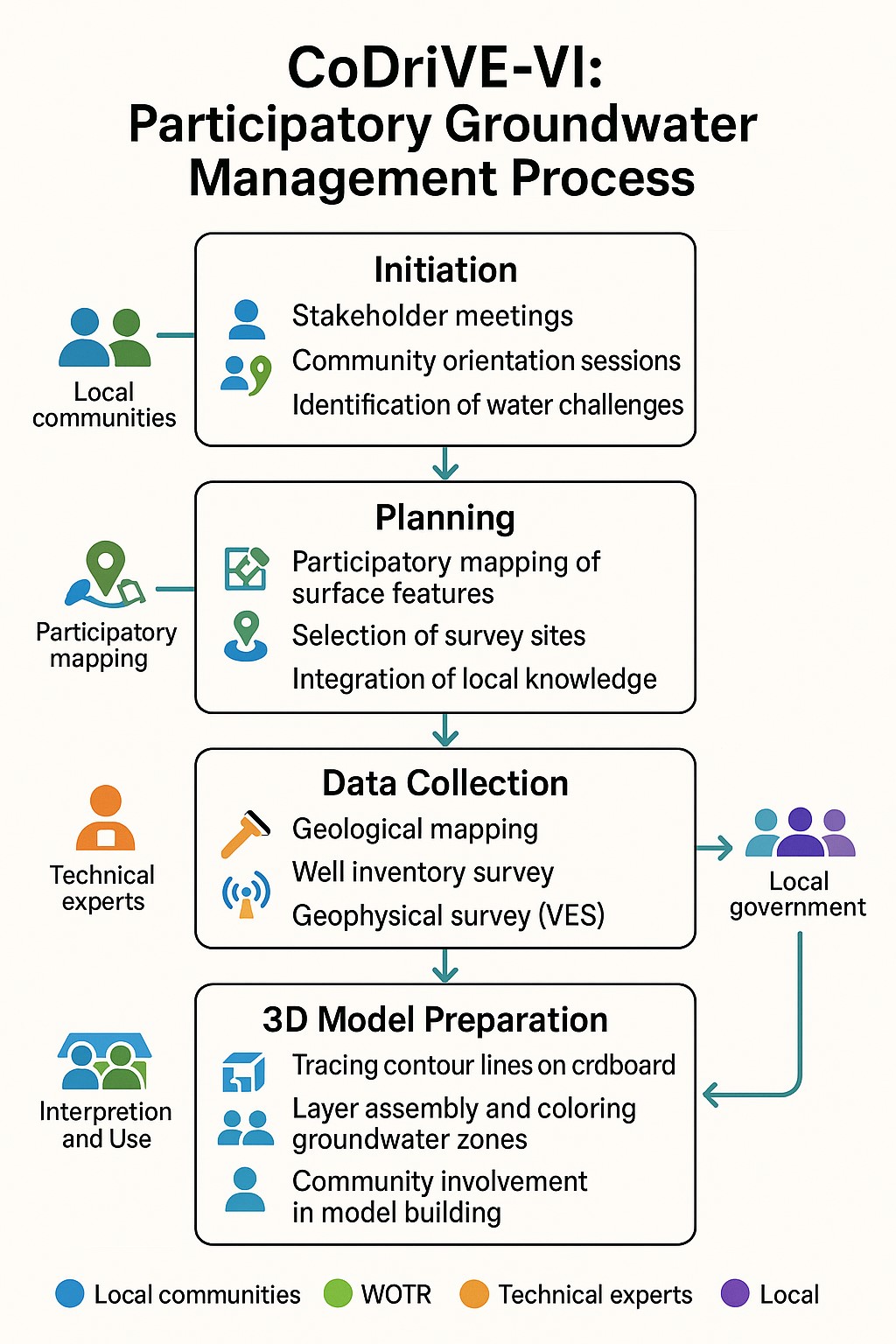
Тодорхойлолт:
The visual summary illustrates the four key stages of the CoDriVE-VI approach
Initiation
-Stakeholder meetings and community orientation sessions are conducted.
-Local water-related challenges are identified.
-Builds a foundation for participatory engagement and problem recognition.
Planning
-Participatory mapping of surface features is carried out.
-Survey sites are selected based on local inputs and technical feasibility.
-Local knowledge is integrated with scientific planning.
Data Collection
-Technical experts conduct geological mapping and well inventory surveys.
- Geophysical surveys (e.g., Vertical Electrical Sounding - VES) are performed.
- Scientific data on groundwater systems is gathered for model development.
3D Model Preparation
-Contour lines are traced on cardboard to build physical models.
-Groundwater zones are assembled and color-coded.
-Communities are actively involved in model building and interpretation for better understanding and use.
Зохиогч:
Pratik Ramteke
3.4 ГТМ-ийн технологи/технологиуд сонгох шийдвэр
Хэрэгжүүлэх Технологи/Технологиудын сонголтыг хийж шийдвэр гаргасан хүнийг тодорхойлно уу:
- оролцооны зарчмын хэсэг болох бүх холбогдох талууд
Тайлбар:
The selection and design of the CoDriVE tool was done through participatory processes involving local communities, WOTR facilitators, and technical experts. Villagers contributed local knowledge and needs, while experts provided scientific input, ensuring collective decision-making.
Шийдвэрийг юунд үндэслэн гаргасан:
- ГТМ-ийн мэдлэгийг баримтжуулалтын үнэлгээ (нотолгоонд суурилсан шийдвэр гаргах)
- Судалгааны үр дүн, ололтууд
- Хувь хүний туршлага ба санал бодол (баримтжуулаагүй)
- Decisions were based on field experiences from over 25 villages, scientific methods (e.g., VES surveys, GIS analysis), and documented evidence on aquifer-based planning. Local knowledge and experiential insights also guided model design and validation.
4. Техникийн дэмжлэг, чадавхи бүрдүүлэх, мэдлэгийн менежмент
4.1 Чадавхи бэхжүүлэх/сургалт
Газар эзэмшигчид / бусад оролцогч талуудад сургалт явуулсан уу?
Тийм
Хэн сургалтанд хамрагдсан бэ:
- Газар ашиглагчид
- хээрийн ажилтан / зөвлөх
Хэрэв шаардлагатай бол хүйс, нас, яс үндэс, гэх мэт. нэмнэ үү:
Training involved both male and female community members, including farmers, youth, and local leaders from diverse socio-economic backgrounds in the villages. Inclusive participation was encouraged throughout
Сургалтын хэлбэр:
- Ажил дээр
- фермерээс -фермер
- үзүүлэнгийн талбай
- Олон нийтийн уулзалт
Хамрагдсан сэвдүүд:
•Basic concepts of hydrogeology and aquifers
•Groundwater vulnerability and common pool resource concepts
•Surface and subsurface mapping
•Use of Participatory 3D Modelling (P3DM)
•Groundwater budgeting
•Climate change impacts on water resources
•Community-led planning and rule-setting for water use
4.2 Зөвлөх үйлчилгээ
Газар ашиглагчдад зөвлөх үйлчилгээ авах боломжтой байдаг уу?
Тийм
Зөвлөх үйлчилгээ үзүүлсэн эсэхийг тогтоо:
- Газар ашиглагчийн талбай дээр
- Тогтмол төвд
Тодорхойлолт / тайлбар:
WOTR provided technical assistance through facilitators and hydrogeology experts. These acted as advisors, guiding communities in surveys, model interpretation, and decision-making.
4.3 Институцийг бэхжүүлэх (байгууллагын хөгжил)
Арга барилаар дамжуулан институц байгуулагдаж эсвэл бэхжсэн үү?
- Тийм, дунд зэрэг
Байгууллагууд бэхжиж, үүсэн бий болсон түвшин(үүд)-г тодорхойлно уу:
- Орон нутгийн
Байгууллага, үүрэг, хариуцлага, гишүүд гэх мэтийг тайлбарлах:
Village Water User Groups (VWUGs) and local governance committees were strengthened to coordinate groundwater management activities. Their roles included planning water use, monitoring aquifer health, implementing community water rules, and facilitating knowledge sharing. Members typically included local farmers, community leaders, and field facilitators
Дэмжлэгийн төрлийг ялга:
- чадавхи бэхжүүлэх / сургалт
- Тоног төхөөрөмж
Дэлгэрэнгүй мэдээллийг өгнө үү:
The strengthening focused on enhancing institutional capacity to support community-driven water resource management. Training sessions improved leadership and technical skills, enabling institutions to take ownership of groundwater sustainability. Equipment such as GPS units and simple monitoring devices were provided to aid local data collection and verification.
4.4 Мониторинг ба үнэлгээ
Мониторинг болон үнэлгээ нь арга барилын хэсэг үү?
Тийм
Тайлбар:
Monitoring was integrated through periodic community workshops, feedback sessions, and participatory verification of groundwater models. Evaluation focused on assessing the accuracy of aquifer mapping, effectiveness of capacity building, and impact on local water management practices.
Хэрэв тийм бол энэ баримт бичиг нь мониторинг, үнэлгээнд ашиглагдахаар зориулагдсан уу?
Тийм
Тайлбар:
This documentation serves as a reference for tracking the implementation process, assessing community engagement, and evaluating outcomes. It can be used to guide adaptive management and inform replication in other regions.
4.5 Судалгаа
Судалгаа арга барилын хэсэг нь байсан уу?
Тийм
Сэдвийг тодруулна уу:
- Социологи
- Экологи
- Технологи
- Hydrogeology and participatory modelling
Дэлгэрэнгүй мэдээллийг өгч, хэн судалгаа явуулсныг бичнэ үү:
Research was integral to developing and refining the CoDriVE methodology. Hydrogeologists and social scientists collaborated with local communities to understand groundwater systems and social dynamics influencing water use. Technology research focused on participatory 3D modeling tools and groundwater budgeting techniques. WOTR staff, partnered with academic institutions and experts in hydrogeology, led the research activities. Community feedback was also systematically documented to improve approaches.
5. Санхүүгийн болон гадаад материаллаг дэмжлэг
5.1 ГТМ-ийн Арга барилын бүрэлдэхүүн хэсгийн жилийн төсөв
Хэрэв жилийн төсөв тодорхойгүй бол хягаарыг тодруулна уу:
- 10,000-100,000
Тайлбар (жнь: санхүүжилтийн гол эх үүсвэр / гол хандивлагчид):
Funding mainly came from government development programs and international donor agencies supporting WOTR’s groundwater management initiatives. Major donors included state water departments and NGOs focused on sustainable water use.
5.2 Газар ашиглагчдад санхүүгийн / материаллаг дэмжлэг үзүүлсэн
Технологи / технологийг хэрэгжүүлэхэд газар ашиглагчид санхүүгийн / материаллаг дэмжлэг авсан уу?
Тийм
Хэрэв тийм бол дэмжлэгийн төрөл(үүд), нөхцөл, болон нийлүүлэгч(чид) бичнэ үү:
Material support included provision of tools and equipment such as GPS devices and monitoring kits, provided free or at subsidized cost by project partners. Some minor financial incentives were given as stipends during training sessions. Support was conditional on active participation in capacity-building and water management activities. Providers included WOTR and partner NGOs.
5.3 Тодорхой зардлыг даахад чиглэсэн дэмжлэгт (хөдөлмөрийн хүчийг оролцуулаад)
- Ажил хөдөлмөр
| Ямар талбайн хэмжээнд | Тэтгэмж, урамшууллыг тодорхойлно уу |
|---|---|
| хэсэгчлэн санхүүждэг | Labour costs for technical support and community mobilization were partly supported by the implementing agency or development partners |
Хэрэв газар ашиглагчийн хөдөлмөрийн хүч чухал байсан бол энэ нь аль хэлбэр байсан:
- сайн дурын
Тайлбар:
Most of the labour contributed by land users and local communities during planning, mapping, and 3D model building was voluntary. In some cases, key technical or facilitative roles were partly supported by the implementing agency. No direct subsidies were provided for equipment, tools, or construction inputs under this approach
5.4 Кредит
Арга барилын хүрээнд ГТМ-ийн үйл ажиллагаанд зориулж зээлд хамрагдсан уу?
Үгүй
5.5 Бусад урамшуулал, хэрэгсэл
ГТМ-ийн технологийг хэрэгжилтийг дэмжихэд ашигласан бусад урамшуулал, хэрэгсэл байсан уу?
Тийм
Хэрэв тийм бол, тодруулна уу:
Supportive policies included local water governance regulations encouraging sustainable groundwater use and community rule enforcement. NGO advocacy helped secure government backing for participatory water management.
6. Нөлөөллийн дүн шинжилгээ ба дүгнэлт
6.1 Арга барилын нөлөөллүүд
Арга барил нь орон нутгийн газар ашиглагчдыг чадваржуулах, оролцогч талуудын оролцоог сайжруулсан уу?
- Үгүй
- Тийм, бага зэрэг
- Тийм, зарим
- Тийм, их
The participatory 3D modelling process directly involved villagers in mapping and decision-making. It created a sense of shared ownership over groundwater resources, enabling community-level rule-making and active participation in groundwater governance
Арга барил нь нотолгоонд суурилсан шийдвэр гаргах боломж олгосон уу?
- Үгүй
- Тийм, бага зэрэг
- Тийм, зарим
- Тийм, их
Scientific tools such as geophysical surveys, geological mapping, and GIS-based groundwater potential maps enabled villagers to base water management decisions on accurate data integrated with traditional knowledge
Арга барил нь ГТМ-ийн технологийг хэрэгжүүлж, хадгалахад газар ашиглагчдад тусласан уу?
- Үгүй
- Тийм, бага зэрэг
- Тийм, зарим
- Тийм, их
By making aquifer dynamics visible, the approach supported sustainable agricultural planning and water budgeting, which are part of SLM practices, although it focused more on literacy and awareness than direct technology implementation
Арга барил нь ГТМ-ийн зардал хэмнэсэн хэрэгжилт, зохицуулалтыг сайжруулсан уу?
- Үгүй
- Тийм, бага зэрэг
- Тийм, зарим
- Тийм, их
It fostered collaboration among community members, local institutions, and technical experts, creating alignment in groundwater-related decisions.
Арга барил нь ГТМ-ийн хэрэгжилтийн санхүүгийн эх үүсвэрийн хүртээмжийг сайжруулах / эргэлтэнд оруулахад чиглэсэн үү?
- Үгүй
- Тийм, бага зэрэг
- Тийм, зарим
- Тийм, их
The approach was low-cost and supported by NGOs and donor funding.
Арга барил нь ГТМ хэрэгжүүлэхэд газар ашиглагчдын мэдлэг, чадварыг сайжруулахад хүргэсэн үү?
- Үгүй
- Тийм, бага зэрэг
- Тийм, зарим
- Тийм, их
The process enhanced groundwater literacy, built capacity for aquifer-based planning, and enabled villagers to understand recharge/discharge zones and water budgeting.
Энэ арга барил бусад сонирхогч талуудын мэдлэг, чадавхийг сайжруулсан уу?
- Үгүй
- Тийм, бага зэрэг
- Тийм, зарим
- Тийм, их
Local government representatives and NGO facilitators gained insights into how to communicate complex hydrogeological data using participatory tools, enhancing their capacity to support SLM.
Арга барил нь оролцогч талуудын хооронд институци, хамтын ажиллагааг бий болгож, бэхжүүлсэн үү?
- Үгүй
- Тийм, бага зэрэг
- Тийм, зарим
- Тийм, их
Village Water Committees and informal community groups were strengthened through workshops, joint planning, and shared understanding of groundwater resources
Энэ арга барил зөрчилдөөнийг багасгасан уу?
- Үгүй
- Тийм, бага зэрэг
- Тийм, зарим
- Тийм, их
By visualizing the shared nature of groundwater resources, it reduced the perception of groundwater as private property and encouraged collective action, which can mitigate user-level conflicts.
Арга барил нь эмзэг бүлгийнхнийг нийгэм, эдийн засгийн хувьд чадавхижуулсан уу?
- Үгүй
- Тийм, бага зэрэг
- Тийм, зарим
- Тийм, их
The approach was inclusive and community-wide. Women’s participation was specifically encouraged, though economic empowerment was not a primary focus.
Арга барил нь жендэрийн тэгш байдлыг сайжруулж, эмэгтэйчүүд, охидыг чадавхжуулсан уу?
- Үгүй
- Тийм, бага зэрэг
- Тийм, зарим
- Тийм, их
Women were involved in workshops and discussions, recognizing their central role in water use.
Арга барил нь газар ашиглагч залуучууд / дараагийн үеийн хүмүүсийг ГТМ-д оролцохыг хөхүүлэн дэмжсэн үү?
- Үгүй
- Тийм, бага зэрэг
- Тийм, зарим
- Тийм, их
The participatory and educational nature of the tool could be adapted for such use.
Арга барил нь ГТМ-ийн технологийг хэрэгжүүлэхэд саад учруулсан газрын эзэмшил / ашиглах эрхийг сайжруулахад чиглэсэн үү?
- Үгүй
- Тийм, бага зэрэг
- Тийм, зарим
- Тийм, их
The approach challenged the perception of groundwater as an individual property, promoting a common-pool perspective.
Арга барил нь чанаржуулсан шим тэжээл/ хүнсний аюулгүй байдалд хүргэсэн үү?
- Үгүй
- Тийм, бага зэрэг
- Тийм, зарим
- Тийм, их
While not directly linked, improved water planning and sustainable groundwater use could contribute indirectly to more reliable irrigation and reduced crop failure.
Арга барил нь зах зээлийн хүртээмжийг сайжруулсан уу?
- Үгүй
- Тийм, бага зэрэг
- Тийм, зарим
- Тийм, их
Арга барил нь ус, ариун цэврийн байгууламжийн хүртээмжийг сайжруулахад хүргэсэн үү?
- Үгүй
- Тийм, бага зэрэг
- Тийм, зарим
- Тийм, их
By improving groundwater management and awareness, the approach contributed to more sustainable access to water for drinking and agriculture.
Арга барил нь эрчим хүчний эх үүсвэр/ илүү тогтвортой ашиглалтад хүргэх үү?
- Үгүй
- Тийм, бага зэрэг
- Тийм, зарим
- Тийм, их
Арга барил нь газар ашиглагчид уур амьсгалын өөрчлөлтөд дасан зохицох чадварыг дээшлүүлж, уур амьсгалын өөрчлөлттэй холбоотой гамшгийг бууруулах чадавхийг сайжруулсан уу?
- Үгүй
- Тийм, бага зэрэг
- Тийм, зарим
- Тийм, их
The tool helped communities understand climate variability's impact on aquifers, supported water risk assessment, and promoted resilience through informed water use planning.
Арга барил нь хөдөлмөр эрхлэлт, орлогын боломжид хүргэсэн үү?
- Үгүй
- Тийм, бага зэрэг
- Тийм, зарим
- Тийм, их
Indirect employment through training, facilitation, and workshops was possible.
6.2 ГТМ-ийг хэрэгжүүлэх газар ашиглагчидын гол санаачилга
- Гамшигийн эрсдэл буурсан
By understanding groundwater vulnerability and recharge/discharge zones, communities became more aware of water-related risks (e.g., drought, borewell failure) and were motivated to manage aquifers collectively.
- нэр хүнд, нийгмийн дарамт / нийгмийн холбоо
As the model was collectively built and discussed in village workshops, peer learning and mutual accountability encouraged participation and collective rule-making.
- Сүлжээ/ бүлэг төсөл/ хөдөлгөөнд гишүүнээр элсүүлэх
Community involvement in WOTR’s Water Stewardship Initiative and other participatory planning efforts created a sense of belonging and continuity with ongoing development processes.
- Байгаль орчны ухамсар
The process helped villagers visualize aquifers as finite, shared resources, leading to increased awareness of groundwater overuse and its ecological consequences.
- зан заншил, ёс суртахуун
The participatory nature respected local knowledge systems, and community values around fairness and shared responsibility played a motivating role
- ГТМ-ийн мэдлэг, туршлага дээшилсэн
Through participation in surveys and the creation of 3D models, communities gained knowledge about geology, aquifers, and sustainable groundwater use.
- зөрчилдөөнийг бууруулах
A visual understanding of shared aquifers helped reduce tensions among farmers and shifted the perspective from private groundwater ownership to common-pool resource management.
6.3 Арга барилын үйл ажиллагааны тогтвортой байдал
Газар ашиглагчид арга барилаар дамжуулан хэрэгжүүлсэн арга хэмжээг тогтвортой хадгалж чадах уу (гадны дэмжлэггүйгээр)?
- Тодорхойгүй
Хэрэв үгүй эсвэл тодорхойгүй бол дэлгэрэнгүй тайлбар өгнө үү:
While the approach may be effective, its long-term viability or replication across other areas could be "uncertain" because:
It relies on external scientific expertise (e.g., geophysical surveys, 3D model building).
There are financial implications (e.g., cost of equipment, facilitation, training).
Communities might not be able to independently replicate or sustain it without ongoing support.
6.4 Арга барилын тогтвортой/давуу тал/боломжууд
| Газар ашиглагчдын тодорхойлсон давуу тал/боломжууд |
|---|
| Enhanced groundwater understanding: The 3D model helped farmers visualize aquifer connectivity, which improved their awareness of water scarcity and led to better planning |
| Collective decision-making: The approach promoted social cohesion and encouraged joint management of groundwater as a common resource. |
| Practical application: Enabled decisions on water budgeting, cropping patterns, and site selection for recharge structures |
| Inclusiveness: Encouraged participation of all sections of the village including women and marginal landholders |
| Created a visual tool that villagers could present in Gram Sabha meetings and discussions with local authorities |
| Эмхэтгэгч, бусад мэдээлэл өгсөн хүмүүсийн өнцгөөс тодорхойлсон давуу тал/боломжууд |
|---|
| Bridges science and local knowledge: CoDriVE-VI effectively demystifies hydrogeology by integrating local understanding with technical surveys |
| Low-cost and replicable: Uses locally available materials (e.g., cardboard) and community manpower. |
| Supports policy alignment: The approach aligns with national programs like NAQUIM and Atal Bhujal Yojana, enabling scale-up |
| Encourages behaviour change through experiential learning—participants shift from individual to community-centered groundwater thinking |
6.5 Арга барилын дутагдалтай/сул тал/аюул болон тэдгээрийн хэрхэн даван туулах арга замууд
| Газар ашиглагч нарын тодорхойлсон сул тал/ дутагдал/ эрсдэл | Тэдгээрийг хэрхэн даван туулах вэ? |
|---|---|
| Time-consuming model preparation: Building the physical 3D model takes effort and coordination. | Train local youth/facilitators to manage the model-building steps and streamline the process |
| Initial difficulty in understanding hydrogeological concepts: Terms like "resistivity" or "aquifer" were hard to grasp | Use simplified language, analogies, and step-by-step facilitation. |
| Models can be physically damaged over time | Store models in safe, community-designated spaces or digitize versions where feasible. |
| Эмхэтгэгч, бусад мэдээлэл өгсөн хүмүүсийн өнцгөөс тодорхойлсон сул тал/ дутагдал/ эрсдэл | Тэдгээрийг хэрхэн даван туулах вэ? |
|---|---|
| Limited scalability without facilitation support: While the model is low-cost, initiating the process requires trained facilitators | Create a cadre of local groundwater ambassadors trained in CoDriVE-VI. |
| Not linked directly to economic incentives: Without immediate financial benefits, long-term engagement may decline. | Integrate with livelihood programs (e.g., water-efficient cropping, irrigation advisories). |
| Not institutionalized within local governance systems | Advocate for formal integration into Gram Panchayat and watershed planning protocols. |
7. Суурь мэдээлэл болон холбоосууд
7.1 Мэдээллийн эх үүсвэр/аргууд
- Хээрийн уулзалт, судалгаа
15
- Газар ашиглагчтай хийсэн ярилцлага
5
- ГТМ-ийн мэргэжилтэн/шинжээчтэй хийсэн ярилцлага
3
- тайлан болон бусад эх сурвалжийн бүрдэл
7.2 Холбогдох бүтээлийн ишлэл
Гарчиг, зохиогч, он, ISBN:
Chemburkar S., Kale E., 2021. Making the Invisible, Visible: Manual for preparing Co-DriVE - Visual Integrator to o
7.3 Холбогдох мэдээллийн интернет дэх нээлттэй холбоосууд
Гарчиг/ тодорхойлолт:
Manual for preparing CoDriVE
URL:
https://wotr-website-publications.s3.ap-south-1.amazonaws.com/156_Making_the_Invisible_Visible_A_Manual_for_Preparing_the_CoDriVE_Visual_Integrator.pdf
Гарчиг/ тодорхойлолт:
Report
URL:
Chemburkar S., Kale E., 2021. Making the Invisible, Visible: Manual for preparing Co-DriVE - Visual Integrator to overlay surface and sub-surface characteristics for sustainable groundwater management, WOTR
Холбоос ба модулууд
Бүгдийг дэлгэх Бүгдийг хаахХолбоосууд
Холбоос байхгүй байна
Модулууд
Модуль байхгүй байна