Ecosystem-wide seasonal grazing management in community land [Кени]
- Шинийг нээх:
- Шинэчлэх:
- Эмхэтгэгч: Peter Tyrrell
- Хянан тохиолдуулагчид: Lance W. Robinson, Enoch Mobisa
- Хянагч: Rima Mekdaschi Studer
technologies_3372 - Кени
Бүлгүүдийг үзэх
Бүгдийг дэлгэх Бүгдийг хаах1. Ерөнхий мэдээлэл
1.2 Технологийг үнэлэх, баримтжуулах ажилд хамаарах мэдээлэл өгсөн хүмүүс, байгууллагуудын холбоо барих мэдээлэл
Мэдээлэл өгсөн хүн (с)
ГТМ мэргэжилтэн:
Технологи баримтжуулах/үнэлэх ажилд дэмжлэг үзүүлсэн төслийн нэр (шаардлагатай бол)
Book project: Guidelines to Rangeland Management in Sub-Saharan Africa (Rangeland Management)1.3 ВОКАТ-аар баримтжуулсан өгөгдлийг ашиглахтай холбоотой нөхцөл
Мэдээллийг хэзээ (газар дээр нь) цуглуулсан бэ?
01/01/2017
Эмхэтгэгч болон гол мэдээлэгч хүн(хүмүүс) WOCAT аргачлалаар баримтжуулсан мэдээллийг ашиглахтай холбоотой нөхцлийг хүлээн зөвшөөрсөн:
Тийм
1.4 Технологи тогтвортой гэдгийг баталгаажуулах
Энэ технологийг газрын доройтлыг бууруулж, газрын тогтвортой менежментийг хангахад тохиромжтой гэж үзэж болох уу?
Үгүй
1.5 ГТМ-ийн Арга барилын талаархи санал асуулгын(д) суурь мэдээлэл
2. ГТМ Технологийн тодорхойлолт
2.1 Технологийн товч тодорхойлолт
Технологийн тодорхойлолт:
Livestock movements are managed through community governance systems to maintain spatial and temporal heterogeneity of pasture, creating a gradient of quality and quantity of pasture across the landscape. This is achieved through clearly designated seasonal grazing areas for livestock and tight controls on settlement areas, grazing patterns and water points. In addition, at the individual herder level, traditional ecological knowledge plays a strong role in the decisions made to improve livestock production
2.2 Технологийн дэлгэрэнгүй тодорхойлолт
Тодорхойлолт:
This technology is applied in the South Rift Valley, Kenya, across a semi-arid landscape, with erratic rainfall averaging 400-600 mm per annum. Water availability is an issue. The perennial Ewaso Ngiro South river flows through the Shompole swamp, a vital drought refuge for livestock and wildlife, before ending up in Lake Natron. The area, roughly 1000 km2, is covered by two group ranches, Olkiramatian and Shompole, which are managed as a single ecological unit. A group ranch is a jointly owned freehold land title given to the customary occupants of communal lands. The total number of occupants of both ranches number roughly 20,000 people, with the majority belonging to the Maasai ethnic group. The ranches have not been subdivided and are not fully sedentary, unlike many other areas of southern Kenya.
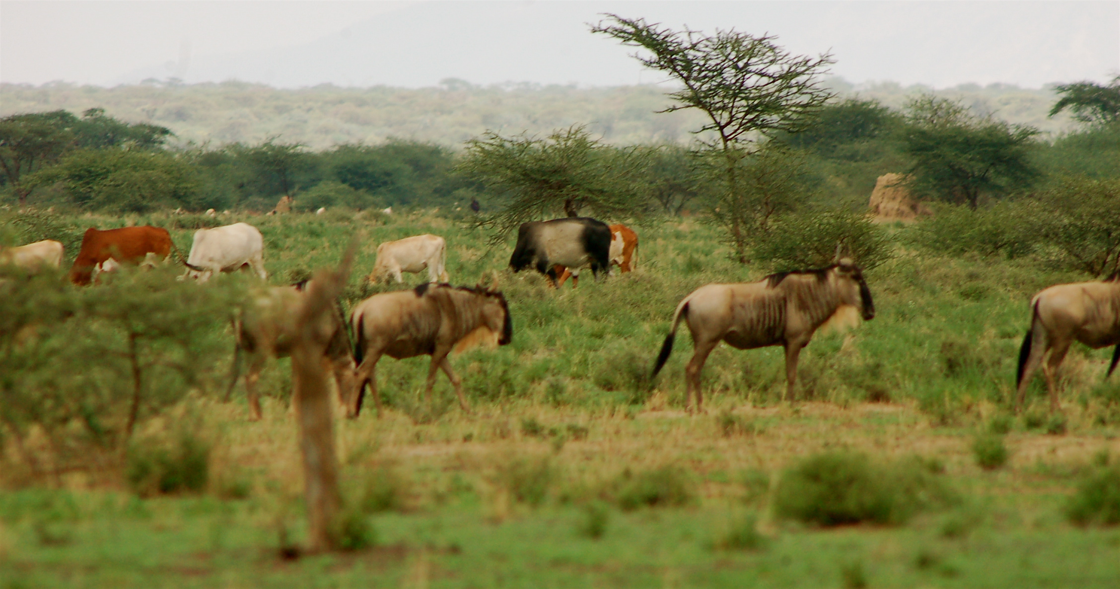
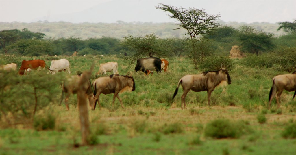
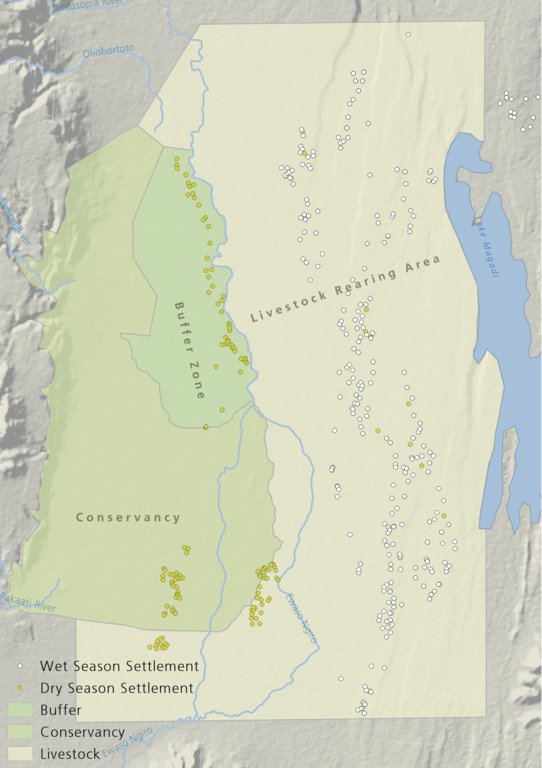
There is a long history of co-existence of wildlife and livestock in Maasialand. In Olkiramatian and Shompole seasonal livestock movements and herding practices are formalized by group ranch grazing plans governed by local committees. The wet season grazing areas are termed “livestock rearing zones”. The dry season grazing areas have been retained as “grass banks” for livestock, and since the early 2000s, have been used additionally as wildlife conservancies for ecotourism (see figure below). Livestock rearing occurs to the east of the Ewaso Ngiro river; grass banks and the wildlife conservancy to the west. Grazing committees from both group ranches manage livestock access to certain areas, with the conservancy (grass bank) rested during the wet season of up to six months. When grazing is permitted in the conservancy, as the dry season progresses, temporary settlements are limited to an area called the “buffer zone”. Livestock must then move into the conservancy from the buffer zones to access this late season grazing. The “livestock rearing zone” is permanently settled and grazed year-round. Within each zone there are small “Olopololis” (grass banks of a few hectares), situated near individual settlements and used to maintain higher quality pasture for weak and young animals. This management strategy ensures that the dry season grazing area is rested during the rains, and it helps to maintain consistently higher biomass and taller grass than that of the wet season grazing area. The higher biomass also corresponds to a rainfall gradient running from the Nguruman Escarpment edge in the western extremity of the group ranches to the dry central rift valley floor in the east. The biomass in the dry season area is used by both livestock and wildlife grazers during the late dry season and in droughts. The grass bank is only grazed out during prolonged dry periods. The Maasai employ a strategy of using the shorter milk-producing grasses of the livestock areas during the rains and the coarser grasses in the grass banks for the dry seasons. The shorter wet season pastures have a higher nutrient content and greater digestibility than the grass bank: this is very important for lactating females. The grass is kept short from both grazing by livestock during the growing seasons and due to intrinsic differences caused by shallower soils and lower rainfall in these grazing areas.
Within this broader governance framework and control of grazing areas, individual decision making is also permitted within these controlled areas. This allows herders to manage livestock to improve production in relation to each herd. For example, individuals might split the herd to take advantage of different energy and nutrient requirements of lactating females, bulls, and calves.
This maintenance and exploitation of forage heterogeneity is vital to the productivity and resilience of the landscape, and this heterogeneity exists at multiple scales, with the major differences existing between the grazing areas, but also smaller difference within them. Resource heterogeneity facilitates wildlife-livestock coexistence. This heterogeneity creates a matrix of varying quality and quantity of forage. Wildlife species have different metabolic requirements and diets, and this varied base ensures that a diverse wild ungulate population is maintained year-round. Late season forage boosts the resilience of wildlife during extreme events. This technology requires a governance structure that is both responsive to the changing ecological conditions and able to build consensus and enforce grazing management
2.3 Технологийн гэрэл зураг
2.5 Энэ үнэлгээнд хамрагдсан технологийг хэрэгжүүлсэн улс орон/ бүс нутаг/ байршил
Улс:
Кени
Улс/аймаг/сум:
Kajiado
Байршлын дэлгэрэнгүй тодорхойлолт:
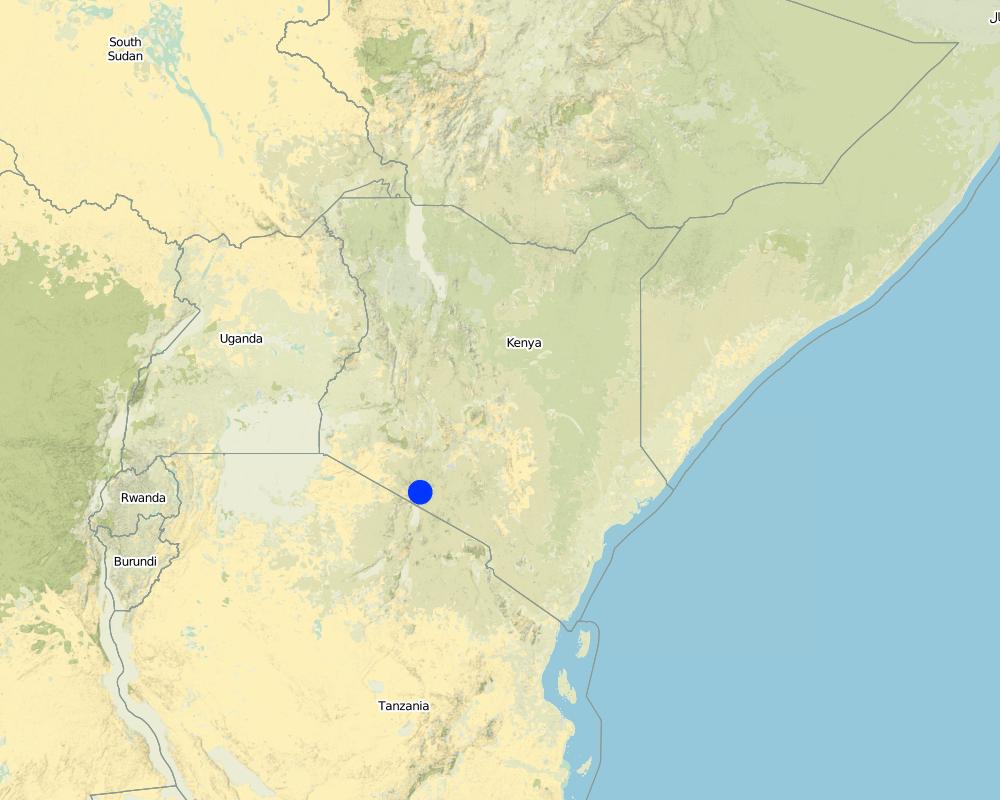
Olkiramatian
Map
×2.6 Хэрэгжсэн хугацаа
Хэрэгжүүлсэн он:
2004
2.7 Технологийн танилцуулга
Технологийг хэрхэн нэвтрүүлснийг тодорхойл:
- Уламжлалт системийн хэсэг (> 50 жил)
Тайлбар (төслийн төрөл г.м.):
The grazing management system is adapted from traditional grazing management of Maasai pastoralists.
3. ГТМ технологийн ангилал
3.1 Технологийн үндсэн зорилго (ууд)
- үйлдвэрлэлийг сайжруулах
- газрын доройтлыг бууруулах, сэргийлэх, нөхөн сэргээх
- экосистемийг хамгаалах
- биологийн төрөл зүйлийг хамгаалах / сайжруулах
- уур амьсгалын өөрчлөлт, түүний үр нөлөөг багасгах
- үр ашигтай эдийн засгийн нөлөөг бий болгох
3.2 Технологи нэвтрүүлсэн газрын одоогийн газар ашиглалтын хэлбэр(үүд)

Бэлчээрийн газар
Бэлчээрийн мал аж ахуйн газар:
- Хагас нүүдлийн/ бэлчээрийн мал аж ахуй
3.3 Газар ашиглалтын тухай нэмэлт мэдээлэл
Технологи хэрэгжүүлсэн газрын усан хангамж:
- Байгалийн усалгаатай
Тайлбар:
The area is semi-arid and receives rainfall erratically, both in space and time, in a bi-modal pattern.
Жилд ургамал ургах улирлын тоо:
- 2
Тодорхойлно уу:
Long rains fall between April - June; Short rains fall between October - December.
Малын нягт (шаардлагатай бол):
Cattle 6.2 / km2; Shoats 52.2 / km2
3.4 Технологи ГТМ-ийн аль бүлэгт хамаарах вэ
- Бэлчээрийн мал аж ахуй ба бэлчээрийн газрын менежмент
3.5 Технологийн хамрах талбай
Технологи өргөн дэлгэрсэн эсхийг тодорхойл:
- газар дээр жигд тархсан
Технологи газар нутгийн хэмжээнд жигд тархсан бол түүний эзлэх талбайг дундажаар тооцож тэмдэглэ:
- 100-1,000 км2
Тайлбар:
The technology formerly worked across the entirety of Maasailand (50,000 km2). However, breakdowns in social structures, culture, and governance arrangements have led to wide-scale losses in traditional grazing management. Olkiramtian and its neighbor Shompole, are two of the few communities managing to graze in such a way to maintain and capitalize on the spatial-temporal heterogeneity of forage resources through merging traditional and modern institutions.
3.6 Технологийг бүрдүүлэх ГТМ арга хэмжээ

Менежментийн арга хэмжээ
- М2: Ашиглалтын менежмент/эрчимийг өөрчлөх
- M3: Байгаль ба нийгмийн орчинд тохируулан зохион байгуулах
- M4: Үйл ажиллагааны цаг хугацаанд том өөрчлөлт орно
3.7 Технологид харгалзах газрын доройтлын төрөл

хөрс усаар эвдрэх
- Wt: Хөрсний гадаргын угаагдал

биологийн доройтол
- Bc: Ургамлан нөмрөг багасах
- Bh: Амьдрах орчин доройтох
- Bq: биомасс буурах
- Bs: Ургамлын чанар, төрөл зүйл, олон янз байдал буурах
3.8 Газрын доройтлоос урьдчилан сэргийлэх, сааруулах ба нөхөн сэргээх
Газрын доройтолтой холбоотойгоор Технологи ямар зорилго тавьсан болохыг тодорхойл:
- газрын доройтлоос урьдчилан сэргийлэх
Тайлбар:
Although in general, this technology aims to prevent land degradation through the maintenance of forage cover; localized degradation does occur across different locations within the landscape, especially in areas of highest livestock impact, such as water points and settlement areas.
4. Техникийн нөхцөл, хэрэгжүүлсэн үйл ажиллагаа, материал ба зардал
4.1 Технологийн техник зураг
4.2 Техникийн үзүүлэлт/ техникийн зургийн тайлбар
The drawing shows the management units used in this seasonally structured grazing management system. The livestock rearing zone, to the east of the Ewaso Nyiro river, is permanently settled and is grazed heavily during the wet season (April - July). During this time herders utilize the short, nutritious grasses in this low biomass area. As forage biomass begins to reduce the community grazing committees meet to discuss the opening of settlements to the west of the Ewaso Nyiro river. This decision is made using traditional ecological knowledge, comparing available forage biomass and the numbers of livestock to previous years and past experiences. Once the grazing has been opened to the west of the river people may settle within the buffer zone. This limits direct access to the higher biomass areas within the conservancy and grass banks, and increases the length of travel for each herd every day, in an effort to preserve forage for longer. Once forage has been depleted in the buffer zones and the periphery of the conservancies, the committees meet and allow access for herders into the conservation areas, which have tall, high biomass, but low-quality grazing. Often access to this area requires considerable distances to be walked by livestock. In recent years, adaptive management systems have led to the settlements within the south of the conservation area to be closed to preserve forage biomass within the swamp and conservation area for a longer period of time; and allow for recovery of partially degraded land.
4.3 Материал болон зардалд хамаарах ерөнхий мэдээлэл
Үнэ өртөг, оруулсан хувь нэмрийг хэрхэн тооцсоныг тодорхойл:
- Технологийн нэгж тус бүр
Нэгжийг тодорхойл:
The two group ranches
Эзэлхүүн, урт зэргийг тодорхойл (тохиромжтой бол):
Approximately 1000km2
Үнэ өртөгийг тооцоход ашигласан мөнгөн нэгж:
- Америк доллар
Хөлсний ажилчны нэг өдрийн цалингийн хэмжээг тодорхойлно уу:
4
4.4 Бий болгох үйл ажиллагаа
Тайлбар:
No activities were required to establish this practice as it has been ongoing and builds on traditional management structures.
4.5 Бий болгоход шаардагдсан зардал, хөрөнгийн өртөг
Тайлбар:
N/A
4.6 Арчилгаа/ урсгал үйл ажиллагаа
| Үйл ажиллагаа | Арга хэмжээний төрөл | Хугацаа/ давтамж | |
|---|---|---|---|
| 1. | Management meetings | Менежментийн | Seasonally |
4.7 Арчилгаа/урсгал ажилд шаардагдсан зардал, хөрөнгийн өртөг (нэг жилд)
Тайлбар:
The only real costs of this technology, which is different to any other form of grazing system, would be the cost of management through meetings. Otherwise the costs are just that of any other livestock production enterprise.
4.8 Зардалд нөлөөлж байгаа хамгийн чухал хүчин зүйл
Өртөг, зардалд нөлөөлөх гол хүчин зүйл:
There are no or little costs to this technology, as it builds off structures of management which are already in place and work organically within the area.
5. Байгаль ба нийгмийн нөхцөл
5.1 Уур амьсгал
Жилийн нийлбэр хур тундас
- < 250 мм
- 251-500 мм
- 501-750 мм
- 751-1,000 мм
- 1,001-1,500 мм
- 1,501-2,000 мм
- 2,001-3,000 мм
- 3,001-4,000 мм
- > 4,000 мм
Жилийн дундаж хур тунадас (хэрэв мэдэгдэж байвал), мм:
400.00
Хур тунадасны талаархи тодорхойлолт/ тайлбар:
Highly variable rainfall both spatially and temporally. Annual average rainfall has a 33%CV.
Холбогдох цаг уурын станцын нэр:
Lale'enok Resource Centre
Агро-уур амьсгалын бүс
- хагас хуурай
- хуурай
5.2 Гадаргын хэлбэр
Дундаж налуу:
- хавтгай (0-2 %)
- бага зэрэг налуу (3-5 %)
- дунд зэрэг налуу (6-10 % )
- хэвгий (11-15 %)
- налуу (16-30 %)
- их налуу (31-60 % )
- эгц налуу (>60 %)
Гадаргын хэлбэр:
- тэгш өндөрлөг / тал
- нуруу
- уулын энгэр
- дов толгод
- бэл
- хөндий
Өндрийн бүслүүр:
- 0-100 д.т.д. м.
- 101-500 д.т.д. м.
- 501-1,000 д.т.д м.
- 1,001-1,500 д.т.д м.
- 1,501-2,000 д.т.д м.
- 2,001-2,500 д.т.д. м.
- 2,501-3,000 д.т.д. м.
- 3,001-4,000 д.т.д м.
- > 4,000 д.т.д. м.
Технологи дараах асуудалд хандсан эсэхийг тодорхойл:
- хамааралгүй
Гадаргын талаархи тодорхойлолт ба бусад тайлбар:
This area lies at the bottom of the rift valley, with the Nguruman Escarpment and Loita Hills towering up to the west. This change in elevation ensures that there is fresh water reaching the area year round and that there is very late season forage available at higher altitudes if required.
5.3 Хөрс
Хөрсний дундаж зузаан:
- маш нимгэн (0-20 см)
- нимгэн (21-50 см)
- дунд зэрэг зузаан (51-80 см)
- зузаан (81-120 cм)
- маш зузаан (>120 cм)
Хөрсний бүтэц (өнгөн хөрс):
- бүдүүн/ хөнгөн (элсэрхэг)
- дундаж (элсэнцэр, шавранцар)
Хөрсний бүтэц (>20 см-ээс доош):
- бүдүүн/ хөнгөн (элсэрхэг)
- дундаж (элсэнцэр, шавранцар)
5.4 Усны хүртээмж ба чанар
Гүний усны түвшин:
> 50 м
Гадаргын усны хүртээмж:
хангалтгүй/ байхгүй
Усны чанар (цэвэршүүлээгүй):
муу чанарын ундны ус (цэвэршүүлэх шаардлагатай)
Усны давсжилтын асуудал бий юу?
Үгүй
Энэ газар үерт автдаг уу?
Тийм
Тогтмол байдал:
тохиолдлын
Усны чанар, нөөцийн талаархи тайлбар ба бусад тодорхойлолт:
Seasonal floods down the Ewaso Nyiro river provide an important water source for the Shompole Swamp. This swamp acts as an import drought refuge for livestock.
5.5 Биологийн олон янз байдал
Зүйлийн олон янз байдал:
- Их
Амьдрах орчны олон янз байдал:
- Их
Биологийн олон янз байдлын талаархи тайлбар ба бусад тодорхойлолт:
The area has an intact community of large herbivores, 21 species of carnivore and a growing population of elephants. This in part due to the habitat diversity and heterogeneity that has been maintained. Habitat diversity is facilitated by elevation changes up the Nguruman Escarpment, a variable rainfall gradient from East to West, the presence of Soda lakes, and the presence of perennial rivers. The area is also an Important Bird Area and is home to two community conservation areas. It holds some of the largest numbers of large mammals outside of government protected areas in Kenya.
5.6 Технологи нэвтрүүлсэн газар ашиглагчдын тухай мэдээлэл
Суурьшмал эсвэл нүүдлийн:
- Хагас-нүүдэлийн
Үйлдвэрлэлийн системийн зах зээлийн чиг баримжаа:
- холимог (амь зуух/ худалдаа наймаа
- худалдаа наймааны/ зах зээлийн
Бусад эх үүсвэрээс олох орлого:
- Нийт орлогын 10 %-иас доош
Чинээлэг байдлын түвшин:
- нэн ядуу
- ядуу
Хувь хүн эсвэл бүлэг:
- Хувь хүн / өрх
- бүлэг / олон нийтийн
Механикжилтын түвшин:
- гар ажил
Хүйс:
- эмэгтэй
- эрэгтэй
Газар ашиглагчдын бусад шинж чанарыг тодорхойл:
All ages are involved in this practice and all genders. It is a way of live using this management.
5.7 Технологи нэвтрүүлсэн газар ашиглагчийн өмчилж буй, эзэмшиж буй, түрээсэлж буй эсвэл ашиглаж буй (ашиглах эрх) газрын талбай
- < 0.5 га
- 0.5-1 га
- 1-2 га
- 2-5 га
- 5-15 га
- 15-50 га
- 50-100 га
- 100-500 га
- 500-1,000 га
- 1,000-10,000 га
- > 10,000 га
Энэ талбай том, жижиг, дунд алинд хамаарах вэ (орон нутгийн нөхцөлд харгалзуулна уу)?
- дунд-хэмжээний
Тайлбар:
This land is managed under two community land titles. The management is at an intermediate scale as it does not address grazing management beyond the ecosystem boundary and across the greater landscape. This larger-scale approach is, however, a critical component of a larger landscape management system which was previously governed under Maasai culture.
5.8 Газар эзэмшил, газар ашиглах эрх, ус ашиглах эрх
Газар өмчлөл:
- нэгдлийн/ тосгон
Газар ашиглах эрх:
- нэгдлийн хэлбэрээр (зохион байгуулалттай)
Ус ашиглах эрх:
- нэгдлийн хэлбэрээр (зохион байгуулалттай)
- Traditional methods of water management through comittees exists in some areas. In other area the creation of Water Resource Users Associations has begun to manage water.
Тайлбар:
The land is owned under two community titles. The land-use is restricted to members of the group ranches, who may allow for reciprocal grazing rights to be exchanged with neighbouring communities.
5.9 Дэд бүтэц, үйлчилгээний хүртээмж
эрүүл мэнд:
- ядуу
- дунд зэргийн
- сайн
боловсрол:
- ядуу
- дунд зэргийн
- сайн
техник зөвлөгөө:
- ядуу
- дунд зэргийн
- сайн
хөдөлмөр эрхлэлт (жишээ нь, ХАА-аас өөр):
- ядуу
- дунд зэргийн
- сайн
зах зээл:
- ядуу
- дунд зэргийн
- сайн
эрчим хүчний хангамж:
- ядуу
- дунд зэргийн
- сайн
зам тээвэр:
- ядуу
- дунд зэргийн
- сайн
усан хангамж ба ариутгал:
- ядуу
- дунд зэргийн
- сайн
санхүүгийн үйлчилгээ:
- ядуу
- дунд зэргийн
- сайн
6. Үр нөлөө ба дүгнэлт
6.1 Технологийн талбайд үзүүлсэн нөлөө
Нийгэм-эдийн засгийн үр нөлөө
Үйлдвэрлэл
тэжээл үйлдвэрлэл
Тайлбар/ тодорхой дурьдах:
This is in contrast to areas without seasonal grazing management.
тэжээлийн чанар
Тайлбар/ тодорхой дурьдах:
This management system works best to preserve lower quality higher biomass fodder. Quality may not increase dramatically, but the creation of short areas of well-fertilized grass near settlements may increase the local quality of fodder during the wet season.
бүтээмж буурах эрсдэл
Тайлбар/ тодорхой дурьдах:
In comparison to other systems the preservation of late season grazing is crucial in preventing complete losses of livestock during droughts.
Нийгэм-соёлын үр нөлөө
соёлын боломжууд
Тайлбар/ тодорхой дурьдах:
Management of land in this manner relies on traditional ecological knowledge for both individual and community decision making. This is dependent on cultural values and understanding, and underpins grazing management in Maasai society.
Экологийн үр нөлөө
Биологийн олон янз байдал: ургамал, амьтан
Ургамалын бүрхэвч
Тайлбар/ тодорхой дурьдах:
This method increase vegetation cover by maintaining heterogeneity of forage resources across the landscape, and resting pasture seasonally to allow for vegetation regrowth.
газрын дээрхи / доорхи карбон
Тайлбар/ тодорхой дурьдах:
Late season forage available. Recovery and rest allows for greater productivity and rainfall use efficiency.
амьтны төрөл, зүйл
Тайлбар/ тодорхой дурьдах:
Maintenance of spatial and temporal heterogeneity of forage resources ensures that wildlife species have access to the variable resources that they require over time.
6.3 Технологийн уур амьсгалын өөрчлөлт, цаг агаарын гамшигт үзэгдэлд өртөх байдал ба эмзэг байдал (газар ашиглагчийн бодлоор)
Уур амьсгалын аажим өөрчлөлт
Уур амьсгалын аажим өөрчлөлт
| Улирал | Уур амьсгалын өөрчлөлт/экстрим үзэгдлийн төрөл | Технологи түүний нөлөөг хэрхэн бууруулж байна? | |
|---|---|---|---|
| жилийн дундаж хур тундас | Бууралт | дунд зэрэг | |
| улирлын хур тундас | чийглэг/борооны улирал | Бууралт | дунд зэрэг |
Уур амьсгалаас хамаарах аюул (гамшиг)
Уур амьсгалын гамшиг
| Технологи түүний нөлөөг хэрхэн бууруулж байна? | |
|---|---|
| ган гачиг | сайн |
6.4 Өртөг ба ашгийн шинжилгээ
Бий болгох зардалтай харьцуулахад ямар ашиг өгсөн бэ (газар ашиглагчийн бодлоор)?
Богино хугацаанд эргэн төлөгдөх байдал:
маш эерэг
Урт хугацаанд эргэн төлөгдөх байдал:
маш эерэг
Арчилгаа/урсгал зардалтай харьцуулахад ямар ашиг өгсөн бэ (газар ашиглагчийн бодлоор)?
Богино хугацаанд эргэн төлөгдөх байдал:
маш эерэг
Урт хугацаанд эргэн төлөгдөх байдал:
маш эерэг
Тайлбар:
No costs to establish and low direct cost of management actions.
6.5 Технологи нэвтрүүлэлт
- 50 -иас их %
Технологи нэвтрүүлсэн хүмүүсээс хэд нь өөрийн хүчээр технологийг хэрэгжүүлсэн бэ, өөрөөр хэлбэл гадны тусламж дэмжлэг авалгүйгээр?
- 90-100 %
Тайлбар:
This system is adopted by most land-users because of the governance systems in place. There are some individuals who may not choose to abide by the rules set out by the committees, but a combination of peer pressure; traditional curses; and fines usually prevent this.
6.6 Дасан зохицох
Бий болсон өөрчлөлтөд зохицуулан технологийг өөрчилсөн үү?
Тийм
Хэрэв Тийм бол ямар өөрчлөлтөд дасан зохицсон бэ:
- уур амьсгалын өөрчлөлт/ экстрим үзэгдэл
Дасан зохицох зорилгоор технологид хийсэн өөрчлөлт (хийц, материал, төрөл зүйл г.м.):
The management is constantly being adapted based on the prevailing ecological conditions. In 2015, over fifty settlements were closed by the community grazing and group ranch committee within the dry season grazing area to allow for pasture regeneration and to consolidate preservation of the dry season grass bank.
6.7 Технологийн давуу тал/боломжууд
| Газар ашиглагчдын тодорхойлсон давуу тал/боломжууд |
|---|
| This technology stems from a community based and is not imposed from a top-down perspective, and tries to create consensus among resource users. |
| Allows individual flexibility within the broader grazing structure so that people can manage livestock within their own objectives. |
| This technology provides forage for livestock into the dry season and drought. |
| Эмхэтгэгч, бусад мэдээлэл өгсөн хүмүүсийн өнцгөөс тодорхойлсон давуу тал/боломжууд |
|---|
| Management in this way also replicates the methodologies used for land management for thousands of years by pastoral people and helps to generate an enabling environment for the coexistence of wildlife, domestic livestock, and people. |
| Ensures that pasture is rested during the growing season within the dry season grazing areas, so that root mass can be established and to ensure grass seed production. |
6.8 Технологийн дутагдалтай/сул тал/аюул болон тэдгээрийг хэрхэн даван туулах арга зам
| Газар ашиглагч нарын тодорхойлсон сул тал/ дутагдал/ эрсдэл | Тэдгээрийг хэрхэн даван туулах вэ? |
|---|---|
| Exploitation of the system by elites in charge of management decisions, allowing their livestock to access preferential grazing, which may not represent the needs of all groups. | Ensure credible management structures in place; with the new community land act, this should encourage greater equity in decision making. |
| Preventing settlement in areas of traditional occupation by certain households. |
| Эмхэтгэгч, бусад мэдээлэл өгсөн хүмүүсийн өнцгөөс тодорхойлсон сул тал/ дутагдал/ эрсдэл | Тэдгээрийг хэрхэн даван туулах вэ? |
|---|---|
| Lack of focus on a production based system and income generation through livestock sales. | Create and enabling environment for change, through market improvement and learning exchanges. |
| Lack of resting and recovery of forage in the wet season grazing area. | Rotate and rest wet season pasture for a few weeks during the growing period, potentially through grazing in the dry season reserve for a longer period. |
7. Ном зүй ба холбоосууд
7.1 Мэдээлэл цуглуулсан арга/эх үүсвэр
- Хээрийн уулзалт, судалгаа
Living in the area for the last four years.
- тайлан болон бусад эх сурвалжийн бүрдэл
7.3 Цахимаар олж болох хэвлэлийн холбоос (ж.нь ном, тайлан, видео г.м.)
Гарчиг/ тодорхойлолт:
Seasonal movements of wildlife and livestock in a heterogeneous pastoral landscape: Implications for coexistence and community based conservation
URL:
http://www.sciencedirect.com/science/article/pii/S2351989417301075
Холбоос ба модулууд
Бүгдийг дэлгэх Бүгдийг хаахХолбоосууд
Холбоос байхгүй байна
Модулууд
Модуль байхгүй байна


