Farm pond [Энэтхэг]
- Шинийг нээх:
- Шинэчлэх:
- Эмхэтгэгч: Channabasappa Metri
- Хянан тохиолдуулагч: –
- Хянагчид: Fabian Ottiger, Alexandra Gavilano
krushi honda (Kannada)
technologies_1474 - Энэтхэг
Бүлгүүдийг үзэх
Бүгдийг дэлгэх Бүгдийг хаах1. Ерөнхий мэдээлэл
1.2 Технологийг үнэлэх, баримтжуулах ажилд хамаарах мэдээлэл өгсөн хүмүүс, байгууллагуудын холбоо барих мэдээлэл
ГТМ мэргэжилтэн:
Benson Roland
Danida KWDP Bijapur
Энэтхэг
ГТМ мэргэжилтэн:
Mujibur Rahman Syed
Danida KWDP Bijapur
Энэтхэг
ГТМ мэргэжилтэн:
Thippeswamaiah
KWDP Daida Bijapur
Энэтхэг
Технологи баримтжуулах/үнэлэх ажилд дэмжлэг үзүүлсэн байгууллага(ууд)-ын нэр (шаардлагатай бол)
Danida assisted Karnataka Watershed Development Project, Bijapur (Danida assisted Karnataka Watershed Development Project, Bijapur) - Энэтхэг1.3 ВОКАТ-аар баримтжуулсан өгөгдлийг ашиглахтай холбоотой нөхцөл
Эмхэтгэгч болон гол мэдээлэгч хүн(хүмүүс) WOCAT аргачлалаар баримтжуулсан мэдээллийг ашиглахтай холбоотой нөхцлийг хүлээн зөвшөөрсөн:
Тийм
1.5 ГТМ Арга барилын Асуулга (ууд) руу хандах (ВОКАТ ашиглан баримтжуулсан)
Stakeholders participation in the project activities [Энэтхэг]
SWC approach is a participatory methodology to empower the community to plan, implement, monitor, evaluate and manage the SWC technology to bring about sustainability
- Эмхэтгэгч: Pranesh Jahagirdar
2. ГТМ Технологийн тодорхойлолт
2.1 Технологийн товч тодорхойлолт
Технологийн тодорхойлолт:
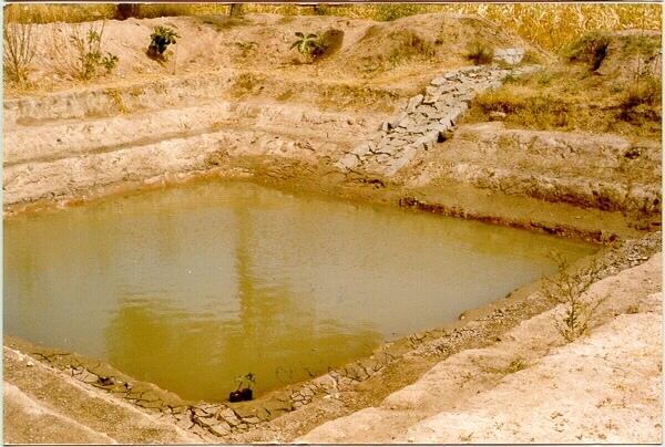
A sunken structure (12 x 12 x 3 m, more suiable), constructed by escavation in arable land with a view of temporary runoff storage tapped for protective irrigation, and to increase percolation for recharge of ground water (to convert surface to subsurface flow)
2.2 Технологийн дэлгэрэнгүй тодорхойлолт
Тодорхойлолт:
A farm pond comprises of excavated portions of 12 x 12 x 3 m with the steps at 0.6m depth each. The excavated earth is deposited all around the structure as a bund, with a burm space of 1m. An inlet cum outlet provided in the course of flow of rain water to collect and dispose the excess runoff.
Purpose of the Technology: (1). For storage of exess runoff. (2) to increase percolation for ground water recharge, (3). To use for protective irrigation during dry period, (4). To stop further deepening of watercourse in arable lands
Establishment / maintenance activities and inputs: Selection of beneficiary is by the community and site selection, Design/ layout and excavation by the project staff with participation of the beneficiary. Desilting of the structure is by the beneficiary
Natural / human environment: surrounding lands are more slopy and with exposed rocks, most of the surrounding area is left for grazing
2.3 Технологийн гэрэл зураг
Медиа галерей
2.5 Энэ үнэлгээнд хамрагдсан технологийг хэрэгжүүлсэн улс орон/ бүс нутаг/ байршил
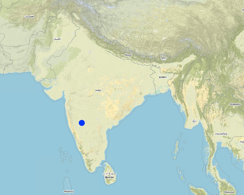
Улс:
Энэтхэг
Улс/аймаг/сум:
Karnataka
Байршлын дэлгэрэнгүй тодорхойлолт:
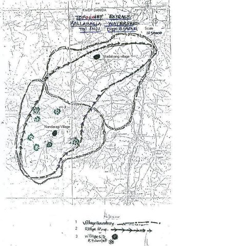
Bijapur district, Hadalsang village
Технологи өргөн дэлгэрсэн эсхийг тодорхойл:
- газар дээр жигд тархсан
Технологи газар нутгийн хэмжээнд жигд тархсан бол түүний эзлэх талбайг тодорхойлно уу (км2-аар):
0.028
Хэрэв талбайн хэмжээ тодорхойгүй бол талбайн хэмжээг ойролцоогоор тодорхойлно уу:
- < 0.1 км2 (10 га)
Тайлбар:
Total area covered by the SLM Technology is 0.028 km2.
The technology area comprising of 2.8 ha within the overall watershed area of 2458 ha. The technology is useful in harvesting the excess rainwater in the arable land and re-use the for protective irigation after the rainy period.
Map
×2.6 Хэрэгжсэн хугацаа
Байгуулсан тодорхой оныг мэдэхгүй бол баримжаа хугацааг тодорхойл:
- <10 жилийн өмнө (саяхны)
2.7 Технологийн танилцуулга
Технологийг хэрхэн нэвтрүүлснийг тодорхойл:
- Гадны төсөл/хөтөлбөрийн дэмжлэгтэйгээр
Тайлбар (төслийн төрөл г.м.):
Department of Agriculture, Govet. Of Karnataka
3. ГТМ технологийн ангилал
3.1 Технологийн үндсэн зорилго (ууд)
- үйлдвэрлэлийг сайжруулах
- экосистемийг хамгаалах
- уур амьсгалын өөрчлөлт/ экстрим байдал болон түүний нөлөөлөлд дасан зохицох
3.2 Технологи нэвтрүүлсэн газрын одоогийн газар ашиглалтын хэлбэр(үүд)

Тариалангийн талбай
- Нэг наст үр тариа
Нэг наст үр тариа - Таримлыг тодорхойлно уу:
- үр тариа - жирийн сорго
- буурцагт ургамал - бусад
- тосны ургамал - кастор
- Chili, brinjal (eggplants), lady's finger (okra, kind of peas)
Жилд ургамал ургах улирлын тоо:
- 2
Тодорхойлно уу:
Longest growing period in days: 120 Longest growing period from month to month: Sep - Dec Second longest growing period in days: 90 Second longest growing period from month to month: Jul - Sep
Тайлбар:
Major land use problems (compiler’s opinion): The lands are very undulating (Class-V as per the Land Capability Classification), with very shallow soils, feasible for only one rainfed crops.
Major land use problems (land users’ perception): Poor yields due to shallow soils that too only one crop in one season, undulating lands leading to more runoff.
Type of cropping system and major crops comments: minor pulses - cereals (green gram-jowar)
Constraints of wastelands / deserts / glaciers / swamps: Highly eroded, unsuitable for any production purposes.
3.4 Усан хангамж
Технологи хэрэгжүүлсэн газрын усан хангамж:
- Байгалийн усалгаатай
Тайлбар:
Water supply: Also mixed rainfed - irrigated (ranked 2)
3.5 Технологи ГТМ-ийн аль бүлэгт хамаарах вэ
- Ус хуримтлуулах
- Усжуулалтын менежмент (усан хангамж, ус зайлуулалт зэрэг.)
3.6 Технологийг бүрдүүлэх ГТМ арга хэмжээ
3.7 Технологид харгалзах газрын доройтлын төрөл

хөрс усаар эвдрэх
- Wt: Хөрсний гадаргын угаагдал
- Wg: Гуу жалгын элэгдэл
- Wo: Усны элэгдлийн дам нөлөө
Тайлбар:
Main type of degradation addressed: Wt: loss of topsoil / surface erosion
Secondary types of degradation addressed: Wg: gully erosion / gullying, Wo: offsite degradation effects
Main causes of degradation: other natural causes (avalanches, volcanic eruptions, mud flows, highly susceptible natural resources, extreme topography, etc.) specify, poverty / wealth (lack of captial)
Secondary causes of degradation: other human induced causes (specify) (other (migration)), labour availability (lack of labour, cost of labour), education, access to knowledge and support services (lack of knowledge)
3.8 Газрын доройтлоос урьдчилан сэргийлэх, сааруулах ба нөхөн сэргээх
Газрын доройтолтой холбоотойгоор Технологи ямар зорилго тавьсан болохыг тодорхойл:
- газрын доройтлоос урьдчилан сэргийлэх
- Газрын доройтлыг бууруулах
Тайлбар:
Main goals: mitigation / reduction of land degradation
Secondary goals: prevention of land degradation
4. Техникийн нөхцөл, хэрэгжүүлсэн үйл ажиллагаа, материал ба зардал
4.1 Технологийн техник зураг

Техник тодорхойлолт (техник зургийн тайлбар):
The drawing showing the details of the farm pond. 12 x 12 x 3 m dimension. Five steps cutting on each side with 1:1 side slope. 1m birm (space) between the earthen bund. 1m wide spilway inlet cum outlet at suitable place of the site.
Location: Kallahalla nala watershed, Indi Taluk. Bijapur district of Karnataka state
Date: 20.4.2004
Technical knowledge required for field staff / advisors: moderate
Technical knowledge required for land users: high
Main technical functions: water harvesting / increase water supply
Secondary technical functions: increase of infiltration, increase / maintain water stored in soil
Structural measure: sediment sand / trap
Depth of ditches/pits/dams (m): 3
Width of ditches/pits/dams (m): 15
Length of ditches/pits/dams (m): 15
Height of bunds/banks/others (m): 1
Width of bunds/banks/others (m): 1
Length of bunds/banks/others (m): 15
Construction material (earth): soil excavated from the pond is used to for bunds all around the structure with 1 m birm space.
Construction material (stone): The spillway Inlet cum Outlet is constructed using stones
For water harvesting: the ratio between the area where the harvested water is applied and the total area from which water is collected is: 1:7
Vegetation is used for stabilisation of structures.
Зохиогч:
C.G Metri, JPO, KWDP Danida Bi
4.2 Материал болон зардалд хамаарах ерөнхий мэдээлэл
бусад/үндэсний мөнгөн нэгж (тодорхойл):
Ruppes
Хэрэв боломжтой бол үндэсний валютын Америк доллартай харьцах харьцааг бичнэ үү (тухайлбал, 1 ам.дол. = 79,9 Бразил реал): 1 ам.дол. =:
46.0
Хөлсний ажилчны нэг өдрийн цалингийн хэмжээг тодорхойлно уу:
0.73
4.3 Бий болгох үйл ажиллагаа
| Үйл ажиллагаа | Хугацаа (улирал) | |
|---|---|---|
| 1. | selection of site and survey, preparation of estimates | summer |
| 2. | submission for sanction of approval | summer |
| 3. | Excavation of the farmpond | summer |
| 4. | construction of inlet/ outlet | before monsoon starts |
4.4 Бий болгоход шаардагдсан зардал, хөрөнгийн өртөг
| Зардлын нэр, төрөл | Хэмжих нэгж | Тоо хэмжээ | Нэгжийн үнэ | Зардал бүрийн нийт өртөг | Нийт дүнгээс газар ашиглагчийн төлсөн % | |
|---|---|---|---|---|---|---|
| Хөдөлмөр эрхлэлт | Labour | ha | 1.0 | 360.0 | 360.0 | 10.0 |
| Барилгын материал | Stone | ha | 1.0 | 109.43 | 109.43 | 100.0 |
| Технологи бий болгох нийт үнэ өртөг | 469.43 | |||||
| Технологи бий болгох нийт үнэ өртөг, ам.доллар | 10.21 | |||||
Тайлбар:
Duration of establishment phase: 0 month(s)
4.5 Арчилгаа/ урсгал үйл ажиллагаа
| Үйл ажиллагаа | Хугацаа/ давтамж | |
|---|---|---|
| 1. | Meeting with the farmer | monsoon/annual |
| 2. | Desilting of farmpond | summer season/once in 2 years |
| 3. | Repair of Inlet/Outlet | summer season/Every year |
| 4. | Trimming of Bund | summer season/Every year |
4.6 Арчилгаа/урсгал ажилд шаардагдсан зардал, хөрөнгийн өртөг (нэг жилд)
| Зардлын нэр, төрөл | Хэмжих нэгж | Тоо хэмжээ | Нэгжийн үнэ | Зардал бүрийн нийт өртөг | Нийт дүнгээс газар ашиглагчийн төлсөн % | |
|---|---|---|---|---|---|---|
| Хөдөлмөр эрхлэлт | Labour | ha | 1.0 | 7.3 | 7.3 | 100.0 |
| Технологийн арчилгаа/урсгал үйл ажиллагаанд шаардагдах нийт үнэ өртөг | 7.3 | |||||
| Технологи арчилах ба урсгал ажлын нийт үнэ өртөг, ам.доллар | 0.16 | |||||
Тайлбар:
12 m x 12 m x 3 m size with all side slope of 1:1 (five steps of 0.6 m deep), Inlet cum outlet spilway constructed with stones. This indicates only the actual cost of construction. (excavation / earth wotk and stone work for inlet/outlet)
4.7 Зардалд нөлөөлж байгаа хамгийн чухал хүчин зүйл
Өртөг, зардалд нөлөөлөх гол хүчин зүйл:
If the implementation site is having the hard strata, then the cost will be more.
5. Байгаль ба нийгмийн нөхцөл
5.1 Уур амьсгал
Жилийн нийлбэр хур тундас
- < 250 мм
- 251-500 мм
- 501-750 мм
- 751-1,000 мм
- 1,001-1,500 мм
- 1,501-2,000 мм
- 2,001-3,000 мм
- 3,001-4,000 мм
- > 4,000 мм
Жилийн дундаж хур тунадас (хэрэв мэдэгдэж байвал), мм:
550.00
Агро-уур амьсгалын бүс
- хагас хуурай
Located on the latitude 16-49'N and longitude 75-43'E .Characterised by hot dry summer (42 °C) and cold dry winters monsoon (July-September) is characterised by high intensity showers followed by pro
5.2 Гадаргын хэлбэр
Дундаж налуу:
- хавтгай (0-2 %)
- бага зэрэг налуу (3-5 %)
- дунд зэрэг налуу (6-10 % )
- хэвгий (11-15 %)
- налуу (16-30 %)
- их налуу (31-60 % )
- эгц налуу (>60 %)
Гадаргын хэлбэр:
- тэгш өндөрлөг / тал
- нуруу
- уулын энгэр
- дов толгод
- бэл
- хөндий
Өндрийн бүслүүр:
- 0-100 д.т.д. м.
- 101-500 д.т.д. м.
- 501-1,000 д.т.д м.
- 1,001-1,500 д.т.д м.
- 1,501-2,000 д.т.д м.
- 2,001-2,500 д.т.д. м.
- 2,501-3,000 д.т.д. м.
- 3,001-4,000 д.т.д м.
- > 4,000 д.т.д. м.
Гадаргын талаархи тодорхойлолт ба бусад тайлбар:
Altitudinal zone: 501-1000 m a.s.l. (594 m a.s.l.)
Slopes on average: Gentle (ridge and valley portion)
5.3 Хөрс
Хөрсний дундаж зузаан:
- маш нимгэн (0-20 см)
- нимгэн (21-50 см)
- дунд зэрэг зузаан (51-80 см)
- зузаан (81-120 cм)
- маш зузаан (>120 cм)
Хөрсний бүтэц (өнгөн хөрс):
- дундаж (элсэнцэр, шавранцар)
Өнгөн хөрсөнд агуулагдах ялзмаг:
- бага (<1 % )
Боломжтой бол хөрсний бүрэн тодорхойлолт, боломжит мэдээллийг өгнө үү, жишээ нь хөрсний төрөл, хөрсний урвалын орчин/хүчиллэг байдал, катион солилцох чадавхи, азотын хэмжээ, давсжилт г.м.
Soil depth on average: Shallow (30 cm)
Soil texture: Medium (medium in valley portion)
Soil fertility: Low (along the slope of the ridge, ranked 1) and medium (valley portion, ranked 2)
Topsoil organic matter: Low (in valley portion)
Soil water storage capacity: Low (hill portion, ranked 1) and medium (valley portion, ranked 2)
5.6 Технологи нэвтрүүлсэн газар ашиглагчдын тухай мэдээлэл
Үйлдвэрлэлийн системийн зах зээлийн чиг баримжаа:
- холимог (амьжиргаа ба худалдаанд)
Бусад эх үүсвэрээс олох орлого:
- Нийт орлогын 10-50 %
Чинээлэг байдлын түвшин:
- ядуу
Газар ашиглагчдын бусад шинж чанарыг тодорхойл:
Population density: 100-200 persons/km2
Annual population growth: 3% - 4%
15% of the land users are very rich and own 5% of the land.
25% of the land users are rich and own 20% of the land.
50% of the land users are average wealthy and own 50% of the land.
10% of the land users are poor and own 15% of the land.
and own 10% of the land.
Off-farm income specification: Through sheep and goat rearing
Level of mechanization: Animal traction, (ranked 1, for ploughing, seed sowing harrowing), manual work (ranked 2, clod crushing, harvesting, threashing) and mechanised (ranked 3, Deep ploughing, levelling)
5.7 Газар ашиглагчийн технологи нэвтрүүлсэн газрын дундаж талбайн хэмжээ
- < 0.5 га
- 0.5-1 га
- 1-2 га
- 2-5 га
- 5-15 га
- 15-50 га
- 50-100 га
- 100-500 га
- 500-1,000 га
- 1,000-10,000 га
- > 10,000 га
Тайлбар:
Average area of land owned or leased by land users applying the Technology:
1-2 ha (ranked 1, marginal farmers [since the land holding decreases because of the fractionation the production and productivity also reduces])
2-5 ha (ranked 2, small farmers)
5-15 ha (ranked 3, big famers)
5.8 Газар эзэмшил, газар ашиглах эрх, ус ашиглах эрх
Газар өмчлөл:
- хувь хүн, өмчийн гэрчилгээтэй
Газар ашиглах эрх:
- хувь хүн
6. Үр нөлөө ба дүгнэлт
6.1 Технологийн талбайд үзүүлсэн нөлөө
Нийгэм-эдийн засгийн үр нөлөө
Үйлдвэрлэл
газар тариалангийн үйлдвэрлэл
Тайлбар/ тодорхой дурьдах:
Second crop also taken
тэжээл үйлдвэрлэл
Тайлбар/ тодорхой дурьдах:
From trees
тэжээлийн чанар
Тайлбар/ тодорхой дурьдах:
From trees
бүтээгдэхүүний олон янз хэлбэр
Тайлбар/ тодорхой дурьдах:
Difference in the crop like on bunds and in the patches of crops.
үйлдвэрлэлийн газар
Тайлбар/ тодорхой дурьдах:
15m x 15m land loss average land holding is very less, thus small & marginal farmers face reduction in the production area with this SWC
газрын менежмент
Тайлбар/ тодорхой дурьдах:
After implementing SWC less area is left for very small and marginal land holding.
Усны хүртээмж ба чанар
мал услах усны хүрэлцээ
Орлого, зарлага
тухайн аж ахуйн орлого
Тайлбар/ тодорхой дурьдах:
Subsistance agriculture
Нийгэм-эдийн засгийн бусад үр нөлөө
Input constraints
Тайлбар/ тодорхой дурьдах:
To bring new area into cultivation
Нийгэм-соёлын үр нөлөө
ГТМ/ газрын доройтлын мэдлэг
Экологийн үр нөлөө
Усны эргэлт/ илүүдэл
усны урсац
Хөрс
хөрсний чийг
хөрсөн бүрхэвч
хөрс алдагдах
Экологийн бусад үр нөлөө
Soil fertility
6.2 Технологийн талбайн гадна үзүүлсэн үр нөлөө
хуурай улиралд ашиглах найдвартай, тогтвортой урсац
голын адагт үерлэх
Тайлбар/ тодорхой дурьдах:
Water storage in farm pond
6.4 Өртөг ба ашгийн шинжилгээ
Бий болгох зардалтай харьцуулахад ямар ашиг өгсөн бэ (газар ашиглагчийн бодлоор)?
Богино хугацаанд эргэн төлөгдөх байдал:
эерэг
Урт хугацаанд эргэн төлөгдөх байдал:
эерэг
Арчилгаа/урсгал зардалтай харьцуулахад ямар ашиг өгсөн бэ (газар ашиглагчийн бодлоор)?
Богино хугацаанд эргэн төлөгдөх байдал:
эерэг
Урт хугацаанд эргэн төлөгдөх байдал:
эерэг
6.5 Технологи нэвтрүүлэлт
Тайлбар:
There is a little trend towards spontaneous adoption of the Technology
Comments on adoption trend: The community is motivated with the benefits from this SWC structure. Some of them have already deepened the farmponds to increase its storage capacity.However, since most of the farmers are having very small land holdings and there was continous dry season from last three years, even if the farmers are motivated and aware of the technology of farmpond, they could not take up on their own (without financial assistance from the project.
6.7 Технологийн давуу тал/боломжууд
| Газар ашиглагчдын тодорхойлсон давуу тал/боломжууд |
|---|
|
Increased storage of water How can they be sustained / enhanced? Desilting by the farmer |
| Reduce gully formation |
|
Bring more area under irrigation How can they be sustained / enhanced? By giving life saving irrigation |
|
Economic benefits How can they be sustained / enhanced? By yields (monocropping to multiple cropping) --> more income |
|
Recycle the silt is beneficial How can they be sustained / enhanced? Other the silt would been lost every year and it is good to retain the soil fertility. |
| Эмхэтгэгч, бусад мэдээлэл өгсөн хүмүүсийн өнцгөөс тодорхойлсон давуу тал/боломжууд |
|---|
|
Storage of water How can they be sustained / enhanced? By deepening |
|
Reduced runoff velocity How can they be sustained / enhanced? By mentainance |
|
Breaching of bunds down stream How can they be sustained / enhanced? By reducing the run-off |
|
Replicability How can they be sustained / enhanced? if a famer has his own labour/ man power then he can go for its construction. |
|
Water harvesting How can they be sustained / enhanced? recycle for protective irrigation during peak season. |
6.8 Технологийн дутагдалтай/сул тал/аюул болон тэдгээрийг хэрхэн даван туулах арга зам
| Газар ашиглагч нарын тодорхойлсон сул тал/ дутагдал/ эрсдэл | Тэдгээрийг хэрхэн даван туулах вэ? |
|---|---|
| Inability to contribute 100% towards cost of construction. | By giving schemes / financial assistance |
| Loosing of portion of cultivable land | By utilizing bunds, change in cropping system/ cropping pattern etc. |
| Эмхэтгэгч, бусад мэдээлэл өгсөн хүмүүсийн өнцгөөс тодорхойлсон сул тал/ дутагдал/ эрсдэл | Тэдгээрийг хэрхэн даван туулах вэ? |
|---|---|
| Difficult to excavate in hard strata | can be done in shallow soils |
| Silt accumulation, if upper catchment is not treated | Treatment of upper catchment |
7. Ном зүй ба холбоосууд
7.1 Мэдээлэл цуглуулсан арга/эх үүсвэр
7.2 Ном, хэвлэлийн ишлэл
Гарчиг, зохиогч, он, ISBN:
Department Guidelines,Project Implementation plan, UAS Dharwad
Хаанаас авч болох вэ? Зардал?
In the office, personal contact
Гарчиг, зохиогч, он, ISBN:
PIP
Хаанаас авч болох вэ? Зардал?
in the office
Гарчиг, зохиогч, он, ISBN:
University of Agril. Sciences Dharwad
Хаанаас авч болох вэ? Зардал?
personal contact
Холбоос ба модулууд
Бүгдийг дэлгэх Бүгдийг хаахХолбоосууд
Stakeholders participation in the project activities [Энэтхэг]
SWC approach is a participatory methodology to empower the community to plan, implement, monitor, evaluate and manage the SWC technology to bring about sustainability
- Эмхэтгэгч: Pranesh Jahagirdar
Модулууд
Модуль байхгүй байна