
Contour Tied Trench [Afeganistão]
- Criação:
- Atualização:
- Compilador/a: Aqila Haidery
- Editor: –
- Revisores: David Streiff, Alexandra Gavilano
Chuquorak (Dari)
technologies_1661 - Afeganistão
Veja as seções
Expandir tudo Recolher tudo1. Informação geral
1.2 Detalhes do contato das pessoas capacitadas e instituições envolvidas na avaliação e documentação da tecnologia
Nome da(s) instituição(ões) que facilitou(ram) a documentação/ avaliação da Tecnologia (se relevante)
HELVETAS (Swiss Intercooperation)1.3 Condições em relação ao uso da informação documentada através de WOCAT
O/a compilador/a e a(s) pessoa(s) capacitada(s) aceitam as condições relativas ao uso de dados documentados através da WOCAT:
Sim
2. Descrição da tecnologia de GST
2.1 Descrição curta da tecnologia
Definição da tecnologia:
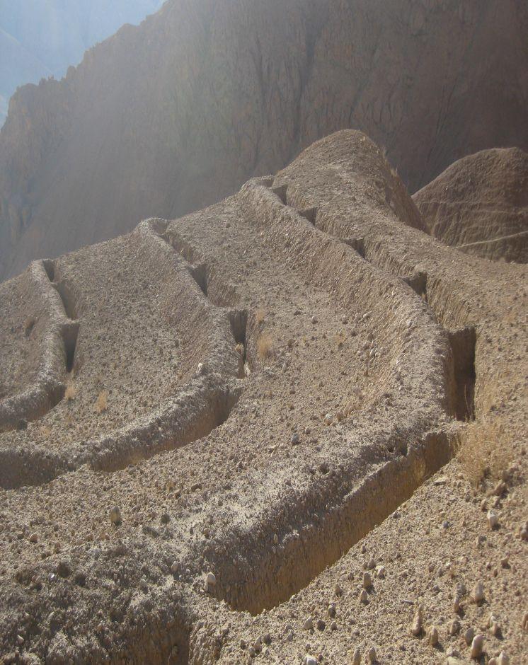
Trenches with soil bunds constructed in a tied manner along contour lines to trap surface runoff and sediments from degraded uplands
2.2 Descrição detalhada da tecnologia
Descrição:
Contour Tied Trenches (CTT) were constructed to trap and retain surface runoff and sediments with the main objective of reducing flash flood risks from the Sou-rakhak watershed which was badly degraded due to overgrazing, excessive cutting of shrubs for fuel wood, rainfed cropping and recurring droughts. The technology was combined with other structural measures like soil bunds, check dams, water ponds, and plantation of fruit, non-fruit trees, fodder crops like alfalfa, Asafoetida and Cumin as cash crops. The watershed is also protected from grazing and shrub cutting by the participating communities. Community bakeries were constructed in the valleys and bio-briquette technology promoted for reducing shrub consump-tion/cutting.
Purpose of the Technology: Continuous Contour Trench (CCT) technology was applied to trap and retain surface runoff and sediments with the main objective of reducing flash flood risks from Sourakhak watershed and preventing damages due to flash floods in the valleys.
Establishment / maintenance activities and inputs: Feasibility studies were conducted and workers from three Community Develop-ment Councils (CDCs) of Roy-e Sang (Kahmard) implemented the construction works based on the technical proposals. The workers were organised by the Sourakhak watershed management committee and they got a daily wage of USD 5 for their labour inputs. About 670 families (276 person days/ha) participated in the construction of CTTs and other technologies.
One supervisor appointed by the communities and a watershed worker from HEL-VETAS Swiss Intercooperation side, both paid by the project, monitored the water-shed works with technical advice from the project staff. The work was carried out in phases and in 4 years (starting 2009) about 65,000 trenches were constructed. About 216 trenches were constructed per hectare and the construction cost was about 1450 USD/ha, which included 1380 USD for labour and 70 USD for tools. The International Swiss Re Award (2009), the Swiss Agency for Development and Cooperation (SDC), HELVETAS Swiss Intercooperation and the participating families financially contributed to the watershed management works.
Natural / human environment: Sourakhak watershed has a semi-arid and temperate climate. The area receives up to 400 mm rainfall (annually) and snow during winter time. The watershed elevation ranges from 2000-3000 m amsl and soil type is sandy-loam to clay type. The land users who applied thsi technology are mostly smallholders. The uplnad areas where the technology was applied is owned by the state, but local communities have long term land use rights.
Sourakhak watershed has a semi-arid and temperate climate. The area receives up to maximum 400 mm rainfall annually in a normal year and snow during winter. About 80% of the rain falls from March to June, with most rain falling in the months of April and May. The watershed is located at an elevation ranging from 2000-3000 m (amsl) and the soil is sandy-loam to clay type. The land users who applied the CTTs are mostly smallholders (with less than 1 ha irrigated land) and they reside in the valley bottoms. The upland areas, where the CTT have been constructed, belong to the state but the local communities have land and water use rights. From a climate change perspective, CTTs will not be much affected by temperature changes or drought. Some trenches could break if there is an extreme rainfall event.
2.3 Fotos da tecnologia
Galeria de Mídias
2.5 País/região/locais onde a tecnologia foi aplicada e que estão cobertos nesta avaliação
País:
Afeganistão
Região/Estado/Província:
Bamyan Province
Especificação adicional de localização:
Kahmard district
Especifique a difusão da tecnologia:
- Uniformemente difundida numa área
Se a Tecnologia estiver uniformemente distribuída por uma área, especifique a área coberta (em km2):
3,0
Se a área precisa não for conhecida, indicar a área aproximada coberta:
- 1-10 km2
Comentários:
Total area covered by the SLM Technology is 3 km2.
About 65,000 trenches each measuring 5 m in length x 0.7 m in depth and 0.7 m in width (in middle) were constructed manually.
2.6 Data da implementação
Caso o ano exato seja desconhecido, indique a data aproximada:
- menos de 10 anos atrás (recentemente)
2.7 Introdução da tecnologia
Especifique como a tecnologia foi introduzida:
- através de projetos/intervenções externas
Comentários (tipos de projeto, etc.):
The project started in 2008.
3. Classificação da tecnologia de GST
3.1 Principal/principais finalidade(s) da tecnologia
- Reduz, previne, recupera a degradação do solo
- Reduzir riscos de desastre
3.2 Tipo(s) atualizado(s) de uso da terra onde a tecnologia foi aplicada

Pastagem
Pastagem extensiva:
- Pastoralismo semi-nômade
Comentários:
Major land use problems (compiler’s opinion): Depleted soils, poor vegetative cover, deep gullies leading which trigger severe flash floods.
Major land use problems (land users’ perception): Severe flash floods from the degraded watershed.
Future (final) land use (after implementation of SLM Technology): Mixed: Mo: Other
Number of growing seasons per year: 1
Longest growing period in days: 180; Longest growing period from month to month: March to July
3.3 O uso do solo mudou devido à implementação da Tecnologia?
Pastagem
- Extensive grazing
3.4 Abastecimento de água
Abastecimento de água para a terra na qual a tecnologia é aplicada:
- Precipitação natural
3.5 Grupo de GST ao qual pertence a tecnologia
- Reserva ( suspensão do uso, apoio à recuperação)
- Medidas de curva de nível
- Desvio e drenagem de água
3.6 Medidas de GST contendo a tecnologia

Medidas estruturais
- S4: Valas de nível, fossos
3.7 Principais tipos de degradação da terra abordados pela tecnologia

Erosão do solo pela água
- Wt: Perda do solo superficial/erosão de superfície
- Wo: efeitos de degradação externa

Degradação biológica
- Bc: redução da cobertura vegetal
Comentários:
Secondary types of degradation addressed: Bc: reduction of vegetation cover
Main causes of degradation: over-exploitation of vegetation for domestic use (Shrubs used for fuel), overgrazing (Mainly by sheep and goats), governance / institutional (No management system either by the government or local communities)
Secondary causes of degradation: droughts (Slow recovery of natural vegetation), population pressure, war and conflicts (Cutting of Juniper trees)
3.8 Redução, prevenção ou recuperação da degradação do solo
Especifique o objetivo da tecnologia em relação a degradação da terra:
- Recuperar/reabilitar solo severamente degradado
4. Especificações técnicas, implementação de atividades, entradas e custos
4.1 Desenho técnico da tecnologia
Especificações técnicas (relacionada ao desenho técnico):
Technical specifications of Contour Tied Trench with soil bunds constructed at Sourakhak wa-tershed. Fruit and non-fruit trees have been planted at a few selected sites in the watershed as vegetative measures. The plant survival per cent was about 10% due to drought, rodent problem and poor adaptation of the tree saplings brought from a different natural environment. The sites are protected from grazing and shrub cutting leading to better land cover.
The trenches have the capacity to store about 159,250 cu.m of water. Kahmard receives up to 350 mm rainfall per year. Considering catchment area of 3 km2 the trenches can hold all the water if there was 50 mm rain at a time, which is rare.Trench size: 5 m (L), 1m at top and 0.4 m at bottom (W), 0.7 m (D)
Distance between trench in a row = 0.3-0.7 m and spacing between contours = 4-8 m depending on the slope (steeper slopes have less distance)
Soil bund size: 5.5 m (L), 0.7 m/0.4 m (W), 0.5 m (H)
The trenches have the capacity to store about 159,250 cu.m of water. Kahmard receives up to 350 mm rainfall per year. Considering catchment area of 3 km2 the trenches can hold all the water if there was 50 mm rainfall at a time, which is rare.
Location: Afghanistan. Kahmard/Bamyan
Date: 12/12/2012
Technical knowledge required for field staff / advisors: high (Initial stages. It is a new technology for most field staff.)
Technical knowledge required for land users: high (Initial stages. Land users have to learn first where to apply, how to apply and maintain this technology and also the method for preparing contour lines.)
Main technical functions: control of dispersed runoff: retain / trap
Secondary technical functions: reduction of slope length, increase of infiltration
Retention/infiltration ditch/pit, sediment/sand trap
Spacing between structures (m): 4-8
Depth of ditches/pits/dams (m): 0.7
Width of ditches/pits/dams (m): 0.7
Length of ditches/pits/dams (m): 5
Height of bunds/banks/others (m): 0.5
Width of bunds/banks/others (m): 0.7
Length of bunds/banks/others (m): 5.5
Autor:
Ahmad Ali Sediqi, HELVETAS Swiss Intercooperation
4.2 Informação geral em relação ao cálculo de entradas e custos
Especifique a moeda utilizada para os cálculos de custo:
- USD
Indique a média salarial da mão-de-obra contratada por dia:
5.00
4.3 Atividades de implantação
| Atividade | Periodicidade (estação do ano) | |
|---|---|---|
| 1. | construction of trenches | summer and autumn |
4.4 Custos e entradas necessárias para a implantação
| Especifique a entrada | Unidade | Quantidade | Custos por unidade | Custos totais por entrada | % dos custos arcados pelos usuários da terra | |
|---|---|---|---|---|---|---|
| Mão-de-obra | Construction of trenches | persons/day/ha | 276,0 | 5,0 | 1380,0 | 10,0 |
| Equipamento | Tools | ha | 1,0 | 70,0 | 70,0 | 90,0 |
| Custos totais para a implantação da tecnologia | 1450,0 | |||||
| Custos totais para o estabelecimento da Tecnologia em USD | 1450,0 | |||||
Comentários:
Duration of establishment phase: 36 month(s)
4.5 Atividades recorrentes/manutenção
| Atividade | Periodicidade/frequência | |
|---|---|---|
| 1. | Repair trenches | Spring/once per year |
4.6 Custos e entradas necessárias pata a manutenção/atividades recorrentes (por ano)
| Especifique a entrada | Unidade | Quantidade | Custos por unidade | Custos totais por entrada | % dos custos arcados pelos usuários da terra | |
|---|---|---|---|---|---|---|
| Mão-de-obra | Repair trenches | persons/day/ha | 1,0 | 5,0 | 5,0 | 100,0 |
| Custos totais para a manutenção da tecnologia | 5,0 | |||||
| Custos totais de manutenção da Tecnologia em USD | 5,0 | |||||
Comentários:
Machinery/ tools: Shovel
4.7 Fatores mais importantes que afetam os custos
Descreva os fatores mais determinantes que afetam os custos:
Labour
5. Ambiente natural e humano
5.1 Clima
Precipitação pluviométrica anual
- <250 mm
- 251-500 mm
- 501-750 mm
- 751-1.000 mm
- 1.001-1.500 mm
- 1.501-2.000 mm
- 2.001-3.000 mm
- 3.001-4.000 mm
- > 4.000 mm
Zona agroclimática
- Semiárido
Thermal climate class: temperate
5.2 Topografia
Declividade média:
- Plano (0-2%)
- Suave ondulado (3-5%)
- Ondulado (6-10%)
- Moderadamente ondulado (11-15%)
- Forte ondulado (16-30%)
- Montanhoso (31-60%)
- Escarpado (>60%)
Formas de relevo:
- Planalto/planície
- Cumes
- Encosta de serra
- Encosta de morro
- Sopés
- Fundos de vale
Zona de altitude:
- 0-100 m s.n.m.
- 101-500 m s.n.m.
- 501-1.000 m s.n.m.
- 1.001-1.500 m s.n.m.
- 1.501-2.000 m s.n.m.
- 2.001-2.500 m s.n.m.
- 2.501-3.000 m s.n.m.
- 3.001-4.000 m s.n.m.
- > 4.000 m s.n.m.
5.3 Solos
Profundidade do solo em média:
- Muito raso (0-20 cm)
- Raso (21-50 cm)
- Moderadamente profundo (51-80 cm)
- Profundo (81-120 cm)
- Muito profundo (>120 cm)
Textura do solo (solo superficial):
- Grosso/fino (arenoso)
- Fino/pesado (argila)
Matéria orgânica do solo superficial:
- Baixo (<1%)
Caso disponível anexe a descrição completa do solo ou especifique as informações disponíveis, p. ex. tipo de solo, PH/acidez do solo, nitrogênio, capacidade de troca catiônica, salinidade, etc.
Soil fertility is low - medium
Soil drainage / infiltration is medium - good
Soil water storage capacity is medium
5.4 Disponibilidade e qualidade de água
Disponibilidade de água de superfície:
Médio
Qualidade da água (não tratada):
Água potável precária (tratamento necessário)
Comentários e outras especificações sobre a qualidade e a quantidade da água:
Availability of surface water: During rainy seasons
Water quality (untreated): Not good but used for animal drinking water using traditional water harvesting structures
5.5 Biodiversidade
Diversidade de espécies:
- Baixo
Comentários e outras especificações sobre biodiversidade:
Gradually improving
5.6 Características dos usuários da terra que utilizam a tecnologia
Orientação de mercado do sistema de produção:
- misto (subsistência/comercial)
Rendimento não agrícola:
- 10-50% de toda renda
Indivíduos ou grupos:
- Grupos/comunidade
Gênero:
- Homens
Indique outras características relevantes dos usuários da terra:
Land users applying the Technology are mainly common / average land users
Difference in the involvement of women and men: Women are not allowed to work in these areas due to local customs.
Population density: 10-50 persons/km2
Annual population growth: 2% - 3%
Relative level of wealth: rich, average, poor
10% of the land users are rich.
40% of the land users are average wealthy.
50% of the land users are poor.
Market orientation of production system: Income from selling sheep and goats and items from livestotck products like carpets.
5.7 Área média de terrenos utilizados pelos usuários de terrenos que aplicam a Tecnologia
- < 0,5 ha
- 0,5-1 ha
- 1-2 ha
- 2-5 ha
- 5-15 ha
- 15-50 ha
- 50-100 ha
- 100-500 ha
- 500-1.000 ha
- 1.000-10.000 ha
- > 10.000 ha
É considerado pequena, média ou grande escala (referente ao contexto local)?
- Pequena escala
5.8 Propriedade de terra, direitos de uso da terra e de uso da água
Propriedade da terra:
- Estado
Direitos do uso da terra:
- Comunitário (organizado)
Direitos do uso da água:
- Comunitário (organizado)
Comentários:
Land is used by families of three community development councils in Kahmard district as common land
5.9 Acesso a serviços e infraestrutura
Saúde:
- Pobre
- Moderado
- Bom
Educação:
- Pobre
- Moderado
- Bom
Assistência técnica:
- Pobre
- Moderado
- Bom
Emprego (p. ex. não agrícola):
- Pobre
- Moderado
- Bom
Mercados:
- Pobre
- Moderado
- Bom
Energia:
- Pobre
- Moderado
- Bom
Vias e transporte:
- Pobre
- Moderado
- Bom
Água potável e saneamento:
- Pobre
- Moderado
- Bom
Serviços financeiros:
- Pobre
- Moderado
- Bom
6. Impactos e declarações finais
6.1 Impactos no local mostrados pela tecnologia
Impactos socioeconômicos
Produção
Produção de forragens
Comentários/especificar:
Increase in natural production due to increased moisture and area protection
Área de produção
Comentários/especificar:
As the area is closed for grazing and shrub cutting
Impactos socioculturais
Instituições comunitárias
Comentários/especificar:
Work is facilitated by watershed management committee
Conhecimento de GST/ degradação da terra
livelihood and human well-being
Comentários/especificar:
It has reduced flash flood risks. As a result, more area in the valleys is productive and damages to houses, roads, gardens, agriculture land have significantly reduced
Impactos ecológicos
Ciclo hídrico/escoamento
Colheita/recolhimento de água
Lençol freático/aquífero
Solo
Umidade do solo
Biodiversidade: vegetação, animais
Diversidade vegetal
6.2 Impactos externos mostrados pela tecnologia
Cheias de jusante
Danos em áreas vizinhas
Comentários/especificar:
Due to less flash floods
6.3 Exposição e sensibilidade da tecnologia às mudanças climáticas graduais e extremos/desastres relacionados ao clima (conforme o ponto de vista dos usuários da terra)
Mudança climática gradual
Mudança climática gradual
| Estação do ano | aumento ou diminuição | Como a tecnologia lida com isso? | |
|---|---|---|---|
| Temperatura anual | aumento | bem |
Extremos (desastres) relacionados ao clima
Desastres meteorológicos
| Como a tecnologia lida com isso? | |
|---|---|
| Temporal local | não bem |
Desastres climatológicos
| Como a tecnologia lida com isso? | |
|---|---|
| Seca | bem |
Outras consequências relacionadas ao clima
Outras consequências relacionadas ao clima
| Como a tecnologia lida com isso? | |
|---|---|
| Período de crescimento reduzido | bem |
Comentários:
Stabilize CTTs with vegetative and management measures. Trench size should be based on hydro-meteorological parameters considering possibility of an extreme event occurring.
6.4 Análise do custo-benefício
Como os benefícios se comparam aos custos de implantação (do ponto de vista dos usuários da terra)?
Retornos a curto prazo:
positivo
Retornos a longo prazo:
muito positivo
Como os benefícios se comparam aos custos recorrentes/de manutenção(do ponto de vista dos usuários da terra)?
Retornos a curto prazo:
positivo
Retornos a longo prazo:
muito positivo
6.5 Adoção da tecnologia
Comentários:
100% of land user families have adopted the Technology with external material support
6.7 Pontos fortes/vantagens/oportunidades da tecnologia
| Pontos fortes/vantagens/oportunidades na visão do usuário da terra |
|---|
| Reduce flash floods risks |
|
Helps in spring recharge How can they be sustained / enhanced? CTTs should be maintained and combined with vegetation measures for better infiltration. |
| Pontos fortes/vantagens/oportunidades na visão do/a compilador/a ou de outra pessoa capacitada |
|---|
|
Reduce flash floods risks How can they be sustained / enhanced? Maintenance and application of vegetative measures along with the trenches. For Instance planting of perennial forage species on the bunds like Alfalfa, Agropyron and Sainfoin.. |
|
CTTs considered better than staggered contour trench if the purpose is to control flash floods as it can trap more runoff and have less chances of damages How can they be sustained / enhanced? Maintenance and correct implementation is necessary |
|
Helps in the establishment of vegetation due to more soil moisture How can they be sustained / enhanced? Combine with conservation practices like mulching |
|
Potential technology for reducing flash flood risks How can they be sustained / enhanced? More training and awareness about the limitations of this technology - where to apply and where not to apply |
6.8 Pontos fracos, desvantagens/riscos da tecnologia e formas de superá-los
| Pontos fracos/vantagens/riscos na visão do/a compilador/a ou de outra pessoa capacitada | Como eles podem ser superados? |
|---|---|
| Soil disturbed during digging and fine clay deposits in the trenches which reduces infiltration | Apply conservation trenches. Planting on the either ends of the trench and soil working to break the clay layering. |
| Establishment costs are high | Initial external support necessary. Linking relief to sustainable land management could be an option. |
| Loss of land for production due to trenching | ntegrate planting of trees and grasses. |
| Trenches break | CTTs must be of right size along the contour lines. Workers must be trained before implementation work and there must be proper supervision. The size of a trench and spacing between trenches should be based on hydro-met parameters. Also, avoid steep sandy (blue) and shallow rocky soil beds |
7. Referências e links
7.1 Métodos/fontes de informação
Links e módulos
Expandir tudo Recolher tudoLinks
Não há links
Módulos
Não há módulos