
Contour Tied Trench [Афганистан]
- Шинийг нээх:
- Шинэчлэх:
- Эмхэтгэгч: Aqila Haidery
- Хянан тохиолдуулагч: –
- Хянагчид: David Streiff, Alexandra Gavilano
Chuquorak (Dari)
technologies_1661 - Афганистан
Бүлгүүдийг үзэх
Бүгдийг дэлгэх Бүгдийг хаах1. Ерөнхий мэдээлэл
1.2 Технологийг үнэлэх, баримтжуулах ажилд хамаарах мэдээлэл өгсөн хүмүүс, байгууллагуудын холбоо барих мэдээлэл
Технологи баримтжуулах/үнэлэх ажилд дэмжлэг үзүүлсэн байгууллага(ууд)-ын нэр (шаардлагатай бол)
HELVETAS (Swiss Intercooperation)1.3 ВОКАТ-аар баримтжуулсан өгөгдлийг ашиглахтай холбоотой нөхцөл
Эмхэтгэгч болон гол мэдээлэгч хүн(хүмүүс) WOCAT аргачлалаар баримтжуулсан мэдээллийг ашиглахтай холбоотой нөхцлийг хүлээн зөвшөөрсөн:
Тийм
2. ГТМ Технологийн тодорхойлолт
2.1 Технологийн товч тодорхойлолт
Технологийн тодорхойлолт:
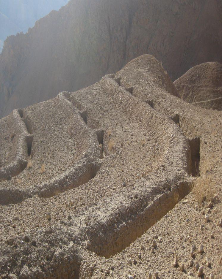
Trenches with soil bunds constructed in a tied manner along contour lines to trap surface runoff and sediments from degraded uplands
2.2 Технологийн дэлгэрэнгүй тодорхойлолт
Тодорхойлолт:
Contour Tied Trenches (CTT) were constructed to trap and retain surface runoff and sediments with the main objective of reducing flash flood risks from the Sou-rakhak watershed which was badly degraded due to overgrazing, excessive cutting of shrubs for fuel wood, rainfed cropping and recurring droughts. The technology was combined with other structural measures like soil bunds, check dams, water ponds, and plantation of fruit, non-fruit trees, fodder crops like alfalfa, Asafoetida and Cumin as cash crops. The watershed is also protected from grazing and shrub cutting by the participating communities. Community bakeries were constructed in the valleys and bio-briquette technology promoted for reducing shrub consump-tion/cutting.
Purpose of the Technology: Continuous Contour Trench (CCT) technology was applied to trap and retain surface runoff and sediments with the main objective of reducing flash flood risks from Sourakhak watershed and preventing damages due to flash floods in the valleys.
Establishment / maintenance activities and inputs: Feasibility studies were conducted and workers from three Community Develop-ment Councils (CDCs) of Roy-e Sang (Kahmard) implemented the construction works based on the technical proposals. The workers were organised by the Sourakhak watershed management committee and they got a daily wage of USD 5 for their labour inputs. About 670 families (276 person days/ha) participated in the construction of CTTs and other technologies.
One supervisor appointed by the communities and a watershed worker from HEL-VETAS Swiss Intercooperation side, both paid by the project, monitored the water-shed works with technical advice from the project staff. The work was carried out in phases and in 4 years (starting 2009) about 65,000 trenches were constructed. About 216 trenches were constructed per hectare and the construction cost was about 1450 USD/ha, which included 1380 USD for labour and 70 USD for tools. The International Swiss Re Award (2009), the Swiss Agency for Development and Cooperation (SDC), HELVETAS Swiss Intercooperation and the participating families financially contributed to the watershed management works.
Natural / human environment: Sourakhak watershed has a semi-arid and temperate climate. The area receives up to 400 mm rainfall (annually) and snow during winter time. The watershed elevation ranges from 2000-3000 m amsl and soil type is sandy-loam to clay type. The land users who applied thsi technology are mostly smallholders. The uplnad areas where the technology was applied is owned by the state, but local communities have long term land use rights.
Sourakhak watershed has a semi-arid and temperate climate. The area receives up to maximum 400 mm rainfall annually in a normal year and snow during winter. About 80% of the rain falls from March to June, with most rain falling in the months of April and May. The watershed is located at an elevation ranging from 2000-3000 m (amsl) and the soil is sandy-loam to clay type. The land users who applied the CTTs are mostly smallholders (with less than 1 ha irrigated land) and they reside in the valley bottoms. The upland areas, where the CTT have been constructed, belong to the state but the local communities have land and water use rights. From a climate change perspective, CTTs will not be much affected by temperature changes or drought. Some trenches could break if there is an extreme rainfall event.
2.3 Технологийн гэрэл зураг
Медиа галерей
2.5 Энэ үнэлгээнд хамрагдсан технологийг хэрэгжүүлсэн улс орон/ бүс нутаг/ байршил
Улс:
Афганистан
Улс/аймаг/сум:
Bamyan Province
Байршлын дэлгэрэнгүй тодорхойлолт:
Kahmard district
Технологи өргөн дэлгэрсэн эсхийг тодорхойл:
- газар дээр жигд тархсан
Технологи газар нутгийн хэмжээнд жигд тархсан бол түүний эзлэх талбайг тодорхойлно уу (км2-аар):
3.0
Хэрэв талбайн хэмжээ тодорхойгүй бол талбайн хэмжээг ойролцоогоор тодорхойлно уу:
- 1-10 км2
Тайлбар:
Total area covered by the SLM Technology is 3 km2.
About 65,000 trenches each measuring 5 m in length x 0.7 m in depth and 0.7 m in width (in middle) were constructed manually.
2.6 Хэрэгжсэн хугацаа
Байгуулсан тодорхой оныг мэдэхгүй бол баримжаа хугацааг тодорхойл:
- <10 жилийн өмнө (саяхны)
2.7 Технологийн танилцуулга
Технологийг хэрхэн нэвтрүүлснийг тодорхойл:
- Гадны төсөл/хөтөлбөрийн дэмжлэгтэйгээр
Тайлбар (төслийн төрөл г.м.):
The project started in 2008.
3. ГТМ технологийн ангилал
3.1 Технологийн үндсэн зорилго (ууд)
- газрын доройтлыг бууруулах, сэргийлэх, нөхөн сэргээх
- гамшгийн эрсдлийг бууруулах
3.2 Технологи нэвтрүүлсэн газрын одоогийн газар ашиглалтын хэлбэр(үүд)

Бэлчээрийн газар
Бэлчээрийн мал аж ахуй:
- Хагас нүүдлийн бэлчээрийн аж ахуй
Тайлбар:
Major land use problems (compiler’s opinion): Depleted soils, poor vegetative cover, deep gullies leading which trigger severe flash floods.
Major land use problems (land users’ perception): Severe flash floods from the degraded watershed.
Future (final) land use (after implementation of SLM Technology): Mixed: Mo: Other
Number of growing seasons per year: 1
Longest growing period in days: 180; Longest growing period from month to month: March to July
3.3 Технологи хэрэгжүүлснээр газар ашиглалтад өөрчлөлт гарсан уу?
Бэлчээрийн газар
- Extensive grazing
3.4 Усан хангамж
Технологи хэрэгжүүлсэн газрын усан хангамж:
- Байгалийн усалгаатай
3.5 Технологи ГТМ-ийн аль бүлэгт хамаарах вэ
- Газар нутаг чөлөөлөх (ашиглалтыг зогсоох, нөхөн сэргээх)
- Налуугийн арга хэмжээ
- Усны урсац зохицуулах болон салаалах
3.6 Технологийг бүрдүүлэх ГТМ арга хэмжээ

Барилга байгууламжийн арга хэмжээ
- S4: Тэгшилсэн ба шаталсан шуудуу, нүх
3.7 Технологид харгалзах газрын доройтлын төрөл

хөрс усаар эвдрэх
- Wt: Хөрсний гадаргын угаагдал
- Wo: Усны элэгдлийн дам нөлөө

биологийн доройтол
- Bc: Ургамлан нөмрөг багасах
Тайлбар:
Secondary types of degradation addressed: Bc: reduction of vegetation cover
Main causes of degradation: over-exploitation of vegetation for domestic use (Shrubs used for fuel), overgrazing (Mainly by sheep and goats), governance / institutional (No management system either by the government or local communities)
Secondary causes of degradation: droughts (Slow recovery of natural vegetation), population pressure, war and conflicts (Cutting of Juniper trees)
3.8 Газрын доройтлоос урьдчилан сэргийлэх, сааруулах ба нөхөн сэргээх
Газрын доройтолтой холбоотойгоор Технологи ямар зорилго тавьсан болохыг тодорхойл:
- Хүчтэй доройтсон газрыг нөхөн сэргээх/ сайжруулах
4. Техникийн нөхцөл, хэрэгжүүлсэн үйл ажиллагаа, материал ба зардал
4.1 Технологийн техник зураг
Техник тодорхойлолт (техник зургийн тайлбар):
Technical specifications of Contour Tied Trench with soil bunds constructed at Sourakhak wa-tershed. Fruit and non-fruit trees have been planted at a few selected sites in the watershed as vegetative measures. The plant survival per cent was about 10% due to drought, rodent problem and poor adaptation of the tree saplings brought from a different natural environment. The sites are protected from grazing and shrub cutting leading to better land cover.
The trenches have the capacity to store about 159,250 cu.m of water. Kahmard receives up to 350 mm rainfall per year. Considering catchment area of 3 km2 the trenches can hold all the water if there was 50 mm rain at a time, which is rare.Trench size: 5 m (L), 1m at top and 0.4 m at bottom (W), 0.7 m (D)
Distance between trench in a row = 0.3-0.7 m and spacing between contours = 4-8 m depending on the slope (steeper slopes have less distance)
Soil bund size: 5.5 m (L), 0.7 m/0.4 m (W), 0.5 m (H)
The trenches have the capacity to store about 159,250 cu.m of water. Kahmard receives up to 350 mm rainfall per year. Considering catchment area of 3 km2 the trenches can hold all the water if there was 50 mm rainfall at a time, which is rare.
Location: Afghanistan. Kahmard/Bamyan
Date: 12/12/2012
Technical knowledge required for field staff / advisors: high (Initial stages. It is a new technology for most field staff.)
Technical knowledge required for land users: high (Initial stages. Land users have to learn first where to apply, how to apply and maintain this technology and also the method for preparing contour lines.)
Main technical functions: control of dispersed runoff: retain / trap
Secondary technical functions: reduction of slope length, increase of infiltration
Retention/infiltration ditch/pit, sediment/sand trap
Spacing between structures (m): 4-8
Depth of ditches/pits/dams (m): 0.7
Width of ditches/pits/dams (m): 0.7
Length of ditches/pits/dams (m): 5
Height of bunds/banks/others (m): 0.5
Width of bunds/banks/others (m): 0.7
Length of bunds/banks/others (m): 5.5
Зохиогч:
Ahmad Ali Sediqi, HELVETAS Swiss Intercooperation
4.2 Материал болон зардалд хамаарах ерөнхий мэдээлэл
Үнэ өртөгийг тооцоход ашигласан мөнгөн нэгж:
- Ам.доллар
Хөлсний ажилчны нэг өдрийн цалингийн хэмжээг тодорхойлно уу:
5.00
4.3 Бий болгох үйл ажиллагаа
| Үйл ажиллагаа | Хугацаа (улирал) | |
|---|---|---|
| 1. | construction of trenches | summer and autumn |
4.4 Бий болгоход шаардагдсан зардал, хөрөнгийн өртөг
| Зардлын нэр, төрөл | Хэмжих нэгж | Тоо хэмжээ | Нэгжийн үнэ | Зардал бүрийн нийт өртөг | Нийт дүнгээс газар ашиглагчийн төлсөн % | |
|---|---|---|---|---|---|---|
| Хөдөлмөр эрхлэлт | Construction of trenches | persons/day/ha | 276.0 | 5.0 | 1380.0 | 10.0 |
| Тоног төхөөрөмж | Tools | ha | 1.0 | 70.0 | 70.0 | 90.0 |
| Технологи бий болгох нийт үнэ өртөг | 1450.0 | |||||
| Технологи бий болгох нийт үнэ өртөг, ам.доллар | 1450.0 | |||||
Тайлбар:
Duration of establishment phase: 36 month(s)
4.5 Арчилгаа/ урсгал үйл ажиллагаа
| Үйл ажиллагаа | Хугацаа/ давтамж | |
|---|---|---|
| 1. | Repair trenches | Spring/once per year |
4.6 Арчилгаа/урсгал ажилд шаардагдсан зардал, хөрөнгийн өртөг (нэг жилд)
| Зардлын нэр, төрөл | Хэмжих нэгж | Тоо хэмжээ | Нэгжийн үнэ | Зардал бүрийн нийт өртөг | Нийт дүнгээс газар ашиглагчийн төлсөн % | |
|---|---|---|---|---|---|---|
| Хөдөлмөр эрхлэлт | Repair trenches | persons/day/ha | 1.0 | 5.0 | 5.0 | 100.0 |
| Технологийн арчилгаа/урсгал үйл ажиллагаанд шаардагдах нийт үнэ өртөг | 5.0 | |||||
| Технологи арчилах ба урсгал ажлын нийт үнэ өртөг, ам.доллар | 5.0 | |||||
Тайлбар:
Machinery/ tools: Shovel
4.7 Зардалд нөлөөлж байгаа хамгийн чухал хүчин зүйл
Өртөг, зардалд нөлөөлөх гол хүчин зүйл:
Labour
5. Байгаль ба нийгмийн нөхцөл
5.1 Уур амьсгал
Жилийн нийлбэр хур тундас
- < 250 мм
- 251-500 мм
- 501-750 мм
- 751-1,000 мм
- 1,001-1,500 мм
- 1,501-2,000 мм
- 2,001-3,000 мм
- 3,001-4,000 мм
- > 4,000 мм
Агро-уур амьсгалын бүс
- хагас хуурай
Thermal climate class: temperate
5.2 Гадаргын хэлбэр
Дундаж налуу:
- хавтгай (0-2 %)
- бага зэрэг налуу (3-5 %)
- дунд зэрэг налуу (6-10 % )
- хэвгий (11-15 %)
- налуу (16-30 %)
- их налуу (31-60 % )
- эгц налуу (>60 %)
Гадаргын хэлбэр:
- тэгш өндөрлөг / тал
- нуруу
- уулын энгэр
- дов толгод
- бэл
- хөндий
Өндрийн бүслүүр:
- 0-100 д.т.д. м.
- 101-500 д.т.д. м.
- 501-1,000 д.т.д м.
- 1,001-1,500 д.т.д м.
- 1,501-2,000 д.т.д м.
- 2,001-2,500 д.т.д. м.
- 2,501-3,000 д.т.д. м.
- 3,001-4,000 д.т.д м.
- > 4,000 д.т.д. м.
5.3 Хөрс
Хөрсний дундаж зузаан:
- маш нимгэн (0-20 см)
- нимгэн (21-50 см)
- дунд зэрэг зузаан (51-80 см)
- зузаан (81-120 cм)
- маш зузаан (>120 cм)
Хөрсний бүтэц (өнгөн хөрс):
- бүдүүн/ хөнгөн (элсэрхэг)
- нарийн /хүнд (шаварлаг)
Өнгөн хөрсөнд агуулагдах ялзмаг:
- бага (<1 % )
Боломжтой бол хөрсний бүрэн тодорхойлолт, боломжит мэдээллийг өгнө үү, жишээ нь хөрсний төрөл, хөрсний урвалын орчин/хүчиллэг байдал, катион солилцох чадавхи, азотын хэмжээ, давсжилт г.м.
Soil fertility is low - medium
Soil drainage / infiltration is medium - good
Soil water storage capacity is medium
5.4 Усны хүртээмж ба чанар
Гадаргын усны хүртээмж:
дунд зэрэг
Усны чанар (цэвэршүүлээгүй):
муу чанарын ундны ус (цэвэршүүлэх шаардлагатай)
Усны чанар, нөөцийн талаархи тайлбар ба бусад тодорхойлолт:
Availability of surface water: During rainy seasons
Water quality (untreated): Not good but used for animal drinking water using traditional water harvesting structures
5.5 Биологийн олон янз байдал
Зүйлийн олон янз байдал:
- Бага
Биологийн олон янз байдлын талаархи тайлбар ба бусад тодорхойлолт:
Gradually improving
5.6 Технологи нэвтрүүлсэн газар ашиглагчдын тухай мэдээлэл
Үйлдвэрлэлийн системийн зах зээлийн чиг баримжаа:
- холимог (амьжиргаа ба худалдаанд)
Бусад эх үүсвэрээс олох орлого:
- Нийт орлогын 10-50 %
Хувь хүн эсвэл бүлэг:
- бүлэг / олон нийтийн
Хүйс:
- эрэгтэй
Газар ашиглагчдын бусад шинж чанарыг тодорхойл:
Land users applying the Technology are mainly common / average land users
Difference in the involvement of women and men: Women are not allowed to work in these areas due to local customs.
Population density: 10-50 persons/km2
Annual population growth: 2% - 3%
Relative level of wealth: rich, average, poor
10% of the land users are rich.
40% of the land users are average wealthy.
50% of the land users are poor.
Market orientation of production system: Income from selling sheep and goats and items from livestotck products like carpets.
5.7 Газар ашиглагчийн технологи нэвтрүүлсэн газрын дундаж талбайн хэмжээ
- < 0.5 га
- 0.5-1 га
- 1-2 га
- 2-5 га
- 5-15 га
- 15-50 га
- 50-100 га
- 100-500 га
- 500-1,000 га
- 1,000-10,000 га
- > 10,000 га
Энэ талбай том, жижиг, дунд алинд хамаарах вэ (орон нутгийн нөхцөлд харгалзуулна уу)?
- бага-хэмжээний
5.8 Газар эзэмшил, газар ашиглах эрх, ус ашиглах эрх
Газар өмчлөл:
- төрийн
Газар ашиглах эрх:
- нэгдлийн хэлбэрээр (зохион байгуулалттай)
Ус ашиглах эрх:
- нэгдлийн хэлбэрээр (зохион байгуулалттай)
Тайлбар:
Land is used by families of three community development councils in Kahmard district as common land
5.9 Дэд бүтэц, үйлчилгээний хүртээмж
эрүүл мэнд:
- ядуу
- дунд зэргийн
- сайн
боловсрол:
- ядуу
- дунд зэргийн
- сайн
техник зөвлөгөө:
- ядуу
- дунд зэргийн
- сайн
хөдөлмөр эрхлэлт (жишээ нь, ХАА-аас өөр):
- ядуу
- дунд зэргийн
- сайн
зах зээл:
- ядуу
- дунд зэргийн
- сайн
эрчим хүчний хангамж:
- ядуу
- дунд зэргийн
- сайн
зам тээвэр:
- ядуу
- дунд зэргийн
- сайн
усан хангамж ба ариутгал:
- ядуу
- дунд зэргийн
- сайн
санхүүгийн үйлчилгээ:
- ядуу
- дунд зэргийн
- сайн
6. Үр нөлөө ба дүгнэлт
6.1 Технологийн талбайд үзүүлсэн нөлөө
Нийгэм-эдийн засгийн үр нөлөө
Үйлдвэрлэл
тэжээл үйлдвэрлэл
Тайлбар/ тодорхой дурьдах:
Increase in natural production due to increased moisture and area protection
үйлдвэрлэлийн газар
Тайлбар/ тодорхой дурьдах:
As the area is closed for grazing and shrub cutting
Нийгэм-соёлын үр нөлөө
олон нийтийн институц
Тайлбар/ тодорхой дурьдах:
Work is facilitated by watershed management committee
ГТМ/ газрын доройтлын мэдлэг
livelihood and human well-being
Тайлбар/ тодорхой дурьдах:
It has reduced flash flood risks. As a result, more area in the valleys is productive and damages to houses, roads, gardens, agriculture land have significantly reduced
Экологийн үр нөлөө
Усны эргэлт/ илүүдэл
ус хураах / цуглуулах
гүний усны түвшин / уст давхарга
Хөрс
хөрсний чийг
Биологийн олон янз байдал: ургамал, амьтан
ургамлын төрөл, зүйл
6.2 Технологийн талбайн гадна үзүүлсэн үр нөлөө
голын адагт үерлэх
хөрш зэргэлдээ газарт учирах хохирол
Тайлбар/ тодорхой дурьдах:
Due to less flash floods
6.3 Технологийн уур амьсгалын өөрчлөлт, цаг агаарын гамшигт үзэгдэлд өртөх байдал ба эмзэг байдал (газар ашиглагчийн бодлоор)
Уур амьсгалын аажим өөрчлөлт
Уур амьсгалын аажим өөрчлөлт
| Улирал | Өсөх эсвэл буурах | Технологи түүний нөлөөг хэрхэн бууруулж байна? | |
|---|---|---|---|
| жилийн дундаж температур | Өсөлт | сайн |
Уур амьсгалаас хамаарах аюул (гамшиг)
Цаг уурын гамшигт үзэгдэл
| Технологи түүний нөлөөг хэрхэн бууруулж байна? | |
|---|---|
| орон нутгийн аадар бороо | муу |
Уур амьсгалын гамшиг
| Технологи түүний нөлөөг хэрхэн бууруулж байна? | |
|---|---|
| ган гачиг | сайн |
Уур амьсгалд хамаарах бусад үр дагавар
Уур амьсгалд хамаарах бусад үр дагавар
| Технологи түүний нөлөөг хэрхэн бууруулж байна? | |
|---|---|
| цргалтын хугацаа багасах | сайн |
Тайлбар:
Stabilize CTTs with vegetative and management measures. Trench size should be based on hydro-meteorological parameters considering possibility of an extreme event occurring.
6.4 Өртөг ба ашгийн шинжилгээ
Бий болгох зардалтай харьцуулахад ямар ашиг өгсөн бэ (газар ашиглагчийн бодлоор)?
Богино хугацаанд эргэн төлөгдөх байдал:
эерэг
Урт хугацаанд эргэн төлөгдөх байдал:
маш эерэг
Арчилгаа/урсгал зардалтай харьцуулахад ямар ашиг өгсөн бэ (газар ашиглагчийн бодлоор)?
Богино хугацаанд эргэн төлөгдөх байдал:
эерэг
Урт хугацаанд эргэн төлөгдөх байдал:
маш эерэг
6.5 Технологи нэвтрүүлэлт
Тайлбар:
100% of land user families have adopted the Technology with external material support
6.7 Технологийн давуу тал/боломжууд
| Газар ашиглагчдын тодорхойлсон давуу тал/боломжууд |
|---|
| Reduce flash floods risks |
|
Helps in spring recharge How can they be sustained / enhanced? CTTs should be maintained and combined with vegetation measures for better infiltration. |
| Эмхэтгэгч, бусад мэдээлэл өгсөн хүмүүсийн өнцгөөс тодорхойлсон давуу тал/боломжууд |
|---|
|
Reduce flash floods risks How can they be sustained / enhanced? Maintenance and application of vegetative measures along with the trenches. For Instance planting of perennial forage species on the bunds like Alfalfa, Agropyron and Sainfoin.. |
|
CTTs considered better than staggered contour trench if the purpose is to control flash floods as it can trap more runoff and have less chances of damages How can they be sustained / enhanced? Maintenance and correct implementation is necessary |
|
Helps in the establishment of vegetation due to more soil moisture How can they be sustained / enhanced? Combine with conservation practices like mulching |
|
Potential technology for reducing flash flood risks How can they be sustained / enhanced? More training and awareness about the limitations of this technology - where to apply and where not to apply |
6.8 Технологийн дутагдалтай/сул тал/аюул болон тэдгээрийг хэрхэн даван туулах арга зам
| Эмхэтгэгч, бусад мэдээлэл өгсөн хүмүүсийн өнцгөөс тодорхойлсон сул тал/ дутагдал/ эрсдэл | Тэдгээрийг хэрхэн даван туулах вэ? |
|---|---|
| Soil disturbed during digging and fine clay deposits in the trenches which reduces infiltration | Apply conservation trenches. Planting on the either ends of the trench and soil working to break the clay layering. |
| Establishment costs are high | Initial external support necessary. Linking relief to sustainable land management could be an option. |
| Loss of land for production due to trenching | ntegrate planting of trees and grasses. |
| Trenches break | CTTs must be of right size along the contour lines. Workers must be trained before implementation work and there must be proper supervision. The size of a trench and spacing between trenches should be based on hydro-met parameters. Also, avoid steep sandy (blue) and shallow rocky soil beds |
7. Ном зүй ба холбоосууд
7.1 Мэдээлэл цуглуулсан арга/эх үүсвэр
Холбоос ба модулууд
Бүгдийг дэлгэх Бүгдийг хаахХолбоосууд
Холбоос байхгүй байна
Модулууд
Модуль байхгүй байна