Zhuanglang loess terraces [China]
- Criação:
- Atualização:
- Compilador/a: Yaolin Wang
- Editor: –
- Revisores: David Streiff, Deborah Niggli, Alexandra Gavilano
technologies_1419 - China
Veja as seções
Expandir tudo Recolher tudo1. Informação geral
1.2 Detalhes do contato das pessoas capacitadas e instituições envolvidas na avaliação e documentação da tecnologia
Especialista em GST:
Especialista em GST:
Zhanguo Zhanguo
ISRIC
Países Baixos
Especialista em GST:
Nome do projeto que facilitou a documentação/avaliação da Tecnologia (se relevante)
Book project: where the land is greener - Case Studies and Analysis of Soil and Water Conservation Initiatives Worldwide (where the land is greener)Nome da(s) instituição(ões) que facilitou(ram) a documentação/ avaliação da Tecnologia (se relevante)
ISRIC World Soil Information (ISRIC World Soil Information) - Países BaixosNome da(s) instituição(ões) que facilitou(ram) a documentação/ avaliação da Tecnologia (se relevante)
Department of Resources and Environmental Science, Beijing Normal University (Department of Resources and Environmental Science, Beijing Normal University) - ChinaNome da(s) instituição(ões) que facilitou(ram) a documentação/ avaliação da Tecnologia (se relevante)
GEF/OP12 Gansu Project (GEF/OP12 Gansu Project) - China1.3 Condições em relação ao uso da informação documentada através de WOCAT
O compilador e a(s) pessoa(s) capacitada(s) aceitam as condições relativas ao uso de dados documentados através do WOCAT:
Sim
1.5 Referência ao(s) questionário(s) sobre abordagens GST (documentado(s) usando WOCAT)
Terrace approach [China]
Highly organised campaign to assist land users in creating terraces: support and planning from national down to local level.
- Compilador/a: Yaolin Wang
2. Descrição da tecnologia de GST
2.1 Descrição curta da tecnologia
Definição da tecnologia:
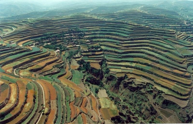
Level bench terraces on the Loess Plateau, converting eroded and degraded sloping land into a series of steps suitable for cultivation.
2.2 Descrição detalhada da tecnologia
Descrição:
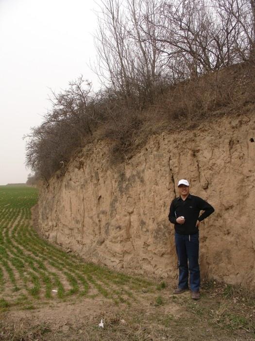
The Loess Plateau in north-central China is characterised by very deep loess parent material (up to 200 m), that is highly erodible and the source of most of the sediment in the lower reaches of the Yellow River.
The plateau is highly dissected by deep gullied valleys and gorges. The steep slopes, occupying 30-40% of the plateau area, have been heavily degraded by severe top soil and gully erosion. Over the whole Loess Plateau approximately 73,350 km2 of these erosion prone slopes have been conserved by terraces.
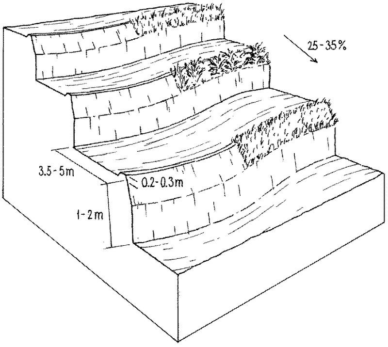
In the case study area (Zhuanglang County) the land that is suitable for terracing has been completely covered. The total terraced area is 1,088 km2, accounting for 90% of the hillsides. The terraces were constructed manually, starting at the bottom of the slopes and proceeding from valley to the ridge. The terraces comprise a riser of earth, with vertical or steeply sloping sides and an approximately flat bed (level bench). Depending on farmers preference some terrace beds are edged by a raised lip (a small earth ridge) which retains rainwater, others remain without lip. The semi-arid climate does not require a drainage system. For typical hillside terraces on slopes of 25-35% the bed width is about 3.5-5 metres with a 1-2 metre riser, involving moving about 2,000-2,500 cubic metres of soil (see table of technical specifications). Generally the risers are not specifically protected, but there may be some natural grasses growing on the upper part. The lower part of the riser is cut vertically into the original soil surface, and has no grass cover, being dry and compact. However it is not erosion-prone since it has a stable structure.
Over most of the Loess Plateau, the soil is very deep and therefore well suited to terrace construction. In addition to downstream benefits, the purpose is to create a better environment for crop production through improved moisture conservation, and improved ease of farming operations. In an average rainfall year, crop yields on terraced land are more than three times higher than they used to be on unterraced, sloping land. The implication is that terrace construction - though labour intensive - pays back in only three to four years when combined with agronomic improvements (such as applying farm yard manure and planting green manure). Some farmers try to make the best use of the upper part of terrace risers by planting cash trees or forage crops - including Hippophae rhamnoides (seabuckthorn), Caragana korshinskii (peashrub) and some leguminous grass. This is locally termed ‘terrace bund economy’. The plants stabilise the risers and at the same time provides extra benefits.
2.3 Fotos da tecnologia
Galeria de Mídias
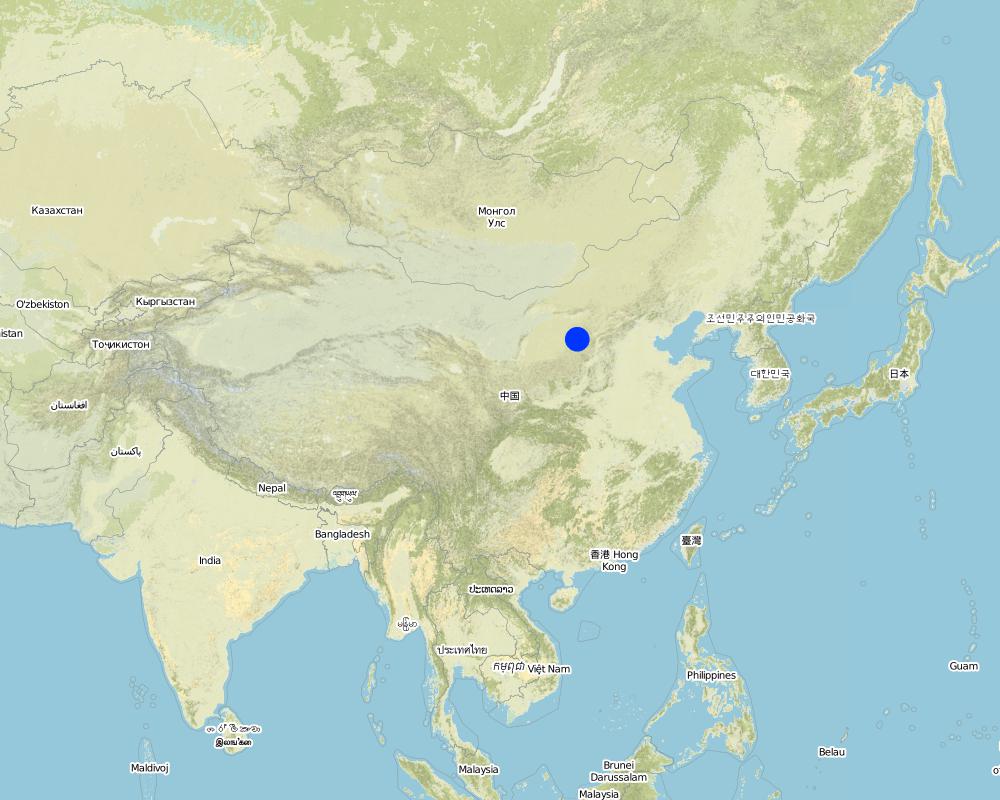
2.5 País/região/locais onde a tecnologia foi aplicada e que estão cobertos nesta avaliação
País:
China
Região/Estado/Província:
Gansu Province (Loess Plateau Region)
Especificação adicional de localização:
Zhuanglang County
Especifique a difusão da tecnologia:
- Uniformemente difundida numa área
Se a Tecnologia estiver uniformemente distribuída por uma área, especifique a área coberta (em km2):
1080,0
Comentários:
Total area covered by the SLM Technology is 1080 km2.
Map
×2.7 Introdução da tecnologia
Especifique como a tecnologia foi introduzida:
- através de projetos/intervenções externas
3. Classificação da tecnologia de GST
3.2 Tipo(s) atualizado(s) de uso da terra onde a tecnologia foi aplicada
Uso do solo misturado dentro da mesma unidade de terra:
Sim
Especificar o uso misto da terra (culturas/ pastoreio/ árvores):
- Agrofloresta

Terra de cultivo
- Cultura anual
- Cultura de árvores e arbustos
Cultivo anual - Especificar culturas:
- cereais - milho
- cereais - painço
- cereais - sorgo
- legumes e leguminosas - ervilhas
- culturas de raiz/tubérculos- batatas
- wheat
Cultivo de árvores e arbustos - Especificar culturas:
- frutas de pomóideas (maçãs, peras, marmelos, etc.)
- frutas com caroço (pêssego, damasco, cereja, ameixa, etc.)
- frutos secos (castanhas do Brasil, pistache, nozes, amêndoas, etc.)
Número de estações de cultivo por ano:
- 1
Especifique:
Longest growing period in days: 160Longest growing period from month to month: May to September
Comentários:
major cash crops: peas
major food crops: wheat, maize, potato, millet, sorghum
perrenial tree and shrub cropping: apple, pear and peach; walnut
Major land use problems (compiler’s opinion): Cultivation of unterraced hillside slopes leads to serious soil erosion and problems of downstream sedimentation.
Loss of topsoil and rainwater in uncontrolled runoff has contributed to declining crop yields.
3.4 Abastecimento de água
Abastecimento de água para a terra na qual a tecnologia é aplicada:
- Precipitação natural
3.5 Grupo de GST ao qual pertence a tecnologia
- Medidas de curva de nível
- terraces
3.6 Medidas de GST contendo a tecnologia

Medidas estruturais
- S1: Terraços
Comentários:
Main measures: structural measures
3.7 Principais tipos de degradação da terra abordados pela tecnologia

Erosão do solo pela água
- Wt: Perda do solo superficial/erosão de superfície
- Wg: Erosão por ravinas/ravinamento
- Wo: efeitos de degradação externa

Deteriorização química do solo
- Cn: declínio de fertilidade e teor reduzido de matéria orgânica (não causado pela erosão)

Degradação da água
- Ha: aridificação
Comentários:
Main type of degradation addressed: Wt: loss of topsoil / surface erosion, Wg: gully erosion / gullying, Wo: offsite degradation effects, Cn: fertility decline and reduced organic matter content, Ha: aridification
Main causes of degradation: soil management (Absence or bad maintenance of erosion control measures), other human induced causes (specify), poverty / wealth (Lack of captial), education, access to knowledge and support services (Lack of knowledge)
Secondary causes of degradation: labour availability (Lack of labour)
3.8 Redução, prevenção ou recuperação da degradação do solo
Especifique o objetivo da tecnologia em relação a degradação da terra:
- Recuperar/reabilitar solo severamente degradado
Comentários:
Main goals: rehabilitation / reclamation of denuded land
4. Especificações técnicas, implementação de atividades, entradas e custos
4.1 Desenho técnico da tecnologia
Especificações técnicas (relacionada ao desenho técnico):
Layout of level bench terraces on the Loess Plateau: the lower, vertical section is cut into the compacted soil. Natural grasses -
or planted grass/ shrub species - protect the more erodible and less steep upper part of the riser. The low ‘lip’ is optional.
Technical knowledge required for field staff / advisors: high
Technical knowledge required for land users: low
Main technical functions: reduction of slope angle, reduction of slope length, increase of infiltration, increase / maintain water stored in soil, water harvesting / increase water supply, retains runoff in-situ, reduces downstream flooding, reduces sediment deposition (a national/regional concern)
Structural measure: level bench terraces
Height of bunds/banks/others (m): 1-2
Width of bunds/banks/others (m): 3.5-5
Construction material (earth): loess parent material
Slope (which determines the spacing indicated above): 30%
Autor:
Mats Gurtner
4.2 Informação geral em relação ao cálculo de entradas e custos
Especifique como custos e entradas foram calculados:
- por área de tecnologia
Indique o tamanho e a unidade de área:
ha
Especifique a moeda utilizada para os cálculos de custo:
- USD
4.3 Atividades de implantação
| Atividade | Periodicidade (estação do ano) | |
|---|---|---|
| 1. | Contour lines are marked out using pegs to show the location for the base of each terrace wall | - |
| 2. | A trench is dug out along the marked line to serve as the foundation | |
| 3. | A trench is dug out along the marked line to serve as the foundation | - |
| 4. | The topsoil between the pegged lines is removed and put aside | |
| 5. | See Annex T3: alternative ways of constructing the wall/riser, bed | |
| 6. | The wall is raised slightly higher to form a lip to retain rainwater on the | - |
4.4 Custos e entradas necessárias para a implantação
| Especifique a entrada | Unidade | Quantidade | Custos por unidade | Custos totais por entrada | % dos custos arcados pelos usuários da terra | |
|---|---|---|---|---|---|---|
| Mão-de-obra | Voluntary and paid (building terraces) | ha | 1,0 | 1200,0 | 1200,0 | 97,0 |
| Mão-de-obra | survey of labour | ha | 1,0 | 60,0 | 60,0 | |
| Equipamento | tools | ha | 1,0 | 30,0 | 30,0 | 100,0 |
| Material de construção | earth | ha | 1,0 | |||
| Custos totais para a implantação da tecnologia | 1290,0 | |||||
| Custos totais para o estabelecimento da Tecnologia em USD | 1290,0 | |||||
Comentários:
Duration of establishment phase: 4 month(s)
4.5 Atividades recorrentes/manutenção
| Atividade | Periodicidade/frequência | |
|---|---|---|
| 1. | 1. Repairing any collapses in the terrace wall – often caused by heavy | |
| 2. | 2. Re-levelling of the terraces where necessary. This work is usually done by hand, using shovels and two-wheel carts. |
4.6 Custos e entradas necessárias pata a manutenção/atividades recorrentes (por ano)
| Especifique a entrada | Unidade | Quantidade | Custos por unidade | Custos totais por entrada | % dos custos arcados pelos usuários da terra | |
|---|---|---|---|---|---|---|
| Mão-de-obra | Reparing terraces | ha | 1,0 | 25,0 | 25,0 | 97,0 |
| Equipamento | tools | ha | 1,0 | 10,0 | 10,0 | |
| Material de construção | earth | ha | 1,0 | |||
| Custos totais para a manutenção da tecnologia | 35,0 | |||||
| Custos totais de manutenção da Tecnologia em USD | 35,0 | |||||
Comentários:
Calculations above are based on the following situation: slopes of about 25-35%, bed width of 3.5-6 m, and a 1-2 m high riser, involving moving about 2,000-2,500 cubic metres of soil. Note: these calculations are based on several years experience in Zhuanglang: that is why they differ in some respects from the standardised table in 2.4.1.
5. Ambiente natural e humano
5.1 Clima
Precipitação pluviométrica anual
- <250 mm
- 251-500 mm
- 501-750 mm
- 751-1.000 mm
- 1.001-1.500 mm
- 1.501-2.000 mm
- 2.001-3.000 mm
- 3.001-4.000 mm
- > 4.000 mm
Zona agroclimática
- Semiárido
5.2 Topografia
Declividade média:
- Plano (0-2%)
- Suave ondulado (3-5%)
- Ondulado (6-10%)
- Moderadamente ondulado (11-15%)
- Forte ondulado (16-30%)
- Montanhoso (31-60%)
- Escarpado (>60%)
Formas de relevo:
- Planalto/planície
- Cumes
- Encosta de serra
- Encosta de morro
- Sopés
- Fundos de vale
Zona de altitude:
- 0-100 m s.n.m.
- 101-500 m s.n.m.
- 501-1.000 m s.n.m.
- 1.001-1.500 m s.n.m.
- 1.501-2.000 m s.n.m.
- 2.001-2.500 m s.n.m.
- 2.501-3.000 m s.n.m.
- 3.001-4.000 m s.n.m.
- > 4.000 m s.n.m.
Indique se a tecnologia é aplicada especificamente em:
- Não relevante
Comentários e outras especificações sobre a topografia:
Slopes on average: also rolling
Altitudinal zone: 501- 2000 m a.s.l.
Landforms: Also ridges
5.3 Solos
Profundidade do solo em média:
- Muito raso (0-20 cm)
- Raso (21-50 cm)
- Moderadamente profundo (51-80 cm)
- Profundo (81-120 cm)
- Muito profundo (>120 cm)
Textura do solo (solo superficial):
- Médio (limoso, siltoso)
Matéria orgânica do solo superficial:
- Baixo (<1%)
Caso disponível anexe a descrição completa do solo ou especifique as informações disponíveis, p. ex. tipo de solo, PH/acidez do solo, nitrogênio, capacidade de troca catiônica, salinidade, etc.
Soil fertility: low-medium
Soil drainage / infiltration: good
5.6 Características dos usuários da terra que utilizam a tecnologia
Orientação de mercado do sistema de produção:
- misto (subsistência/comercial)
Rendimento não agrícola:
- 10-50% de toda renda
Indivíduos ou grupos:
- Indivíduo/unidade familiar
Indique outras características relevantes dos usuários da terra:
Off-farm income specification: working in construction, temporary employments
Market orientation mixed (subsistence and commercial): ash crop (peas) and food crops (potatoes, wheat, maize, millet, sorghum)
5.7 Área média de terrenos utilizados pelos usuários de terrenos que aplicam a Tecnologia
- < 0,5 ha
- 0,5-1 ha
- 1-2 ha
- 2-5 ha
- 5-15 ha
- 15-50 ha
- 50-100 ha
- 100-500 ha
- 500-1.000 ha
- 1.000-10.000 ha
- > 10.000 ha
É considerado pequena, média ou grande escala (referente ao contexto local)?
- Pequena escala
Comentários:
Average area of land owned or leased by land users applying the Technology: < 0.5 ha, 0.5-1 ha, 1-2 ha
5.8 Propriedade de terra, direitos de uso da terra e de uso da água
Propriedade da terra:
- Estado
Direitos do uso da terra:
- Indivíduo
6. Impactos e declarações finais
6.1 Impactos no local mostrados pela tecnologia
Impactos socioeconômicos
Produção
Produção agrícola
Renda e custos
Rendimento agrícola
Outros impactos socioeconômicos
easier field operation
production during the first year of implementation
Impactos socioculturais
Instituições comunitárias
Atenuação de conflitos
Impactos ecológicos
Solo
Umidade do solo
Perda de solo
6.2 Impactos externos mostrados pela tecnologia
Caudal confiável e estável em período seco
Cheias de jusante
Sedimentação a jusante
transported sediments
6.4 Análise do custo-benefício
Como os benefícios se comparam aos custos de implantação (do ponto de vista dos usuários da terra)?
Retornos a curto prazo:
negativo
Retornos a longo prazo:
muito positivo
Como os benefícios se comparam aos custos recorrentes/de manutenção(do ponto de vista dos usuários da terra)?
Retornos a curto prazo:
positivo
Retornos a longo prazo:
muito positivo
6.5 Adoção da tecnologia
Se disponível, determine a quantidade (número de unidades familiares e/ou área abordada):
NA
Comentários:
There is no trend towards spontaneous adoption of the Technology
Comments on adoption trend: - The technology was implemented on a large scale through government initiated mass campaigns.
- The technology has generally not spontaneously spread beyond the areas developed through government intervention: the area that is suitable for terracing has been covered.
- Uncertainty over future land use rights limits the willingness of households to meet the costs of terrace construction.
6.7 Pontos fortes/vantagens/oportunidades da tecnologia
| Pontos fortes/vantagens/oportunidades na visão do usuário da terra |
|---|
| Diversification of production: terracing makes cultivation of new cash crops possible: flax (for linseed oil), pears, apples, apricots, water melon; all these give high returns and thus make terrace construction profitable. |
| Benefits pay back the investments after only three to four years; approx. calculated on the basis of US$ 450 extra income per annum per hectare (for wheat) vs US$ 1,200 labour investment per hectare. |
| Pontos fortes/vantagens/oportunidades na visão do compilador ou de outra pessoa capacitada |
|---|
|
Reduced erosion, reduced loss of rainwater through runoff (increased in water use efficiency) and reduced fertility loss due to reduced slope angle and length How can they be sustained / enhanced? Maintain the quality of terrace construction. |
|
Increased soil moisture How can they be sustained / enhanced? Construct/maintain a terrace lip to retain rainwater on the terrace |
|
Increased crop production (before 1983 hunger and starvation in the area) How can they be sustained / enhanced? Combine with improved crop husbandry. |
| Easier field operations: the level terrace is easier to cultivate than the original hill slope. |
| Improvements of farmers’ living standard and decline in poverty stricken population. |
6.8 Pontos fracos, desvantagens/riscos da tecnologia e formas de superá-los
| Pontos fracos/vantagens/riscos na visão do compilador ou de outra pessoa capacitada | Como eles podem ser superados? |
|---|---|
| Terrace riser can be destroyed by storms – and, sometimes, rodent holes | Good and timely repair and maintenance: planting upper parts of the risers with grass, bushes or even trees help to stabilise the risers but can lead to competition with the crop for water. |
| High cost/input for construction and establishment | Given the high erodibility of the soil and the steep slopes there is no real alternatives to labour-intensive terracing. |
| High loss of soil moisture due to evaporation from the soil surface. Wind erosion due to tillage | Protect soil surface for example by conservation agriculture – comprising permanent cover, crop rotation, reduced tillage – could be supplementary agronomic and vegetative options. |
| Decrease in production in first year | Apply manure and fertilizer. |
7. Referências e links
7.1 Métodos/fontes de informação
7.2 Referências às publicações disponíveis
Título, autor, ano, ISBN:
Terraces In China. Published By Ministry Of Water Resources Beijing, PRC.. 1989.
Título, autor, ano, ISBN:
Conservancy engineering budgetary estimateration. Issued by Ministry of water resources of PRC, Published by Yellow-river water conservancy publishing company, Zhengzhou, PRC. 2003.
Título, autor, ano, ISBN:
A Great Cause for Centuries – 50 Years in Water and Soil Conservation in China. Published by Department of Soil and Water Conservation, Ministry ofWater Resources Beijing, PRC. 2000.
Título, autor, ano, ISBN:
Dongyinglin, Changpiguang, Wangzhihua: Discussion on several questions onincreasing production of the terrace with two banks; Soil and Water Conservation Science and Technology in Shanxi. No. 1, p 36–37. 1990.
Título, autor, ano, ISBN:
Liumingquan, Zhangaiqin, Liyouhua:Pattern engineering of reconstruction the slope cropland; Soil and Water Conservation Science and Technology in Shanxi,No. 3, p 18–21. 1992.
Título, autor, ano, ISBN:
Liangqichun, Changfushuang, Liming: A study on drawing up budgetary estimate quota of terraced field; Bulletin of Soil andWater Conservation, Vol. 21, No. 5, p 41–44. 2001.
Título, autor, ano, ISBN:
Lixuelian, Qiaojiping: Synthetic technology of fertilizing and improving production on the newterrace. Terraces in China. Soil and Water Conservation Science and Technology in Shanxi, No. 3, p 13–14. 1998.
Links e módulos
Expandir tudo Recolher tudoLinks
Terrace approach [China]
Highly organised campaign to assist land users in creating terraces: support and planning from national down to local level.
- Compilador/a: Yaolin Wang
Módulos
Não há módulos