Pasture management through rotational grazing [Tajiquistão]
- Criação:
- Atualização:
- Compilador/a: Malgorzata Conder
- Editor: –
- Revisores: Deborah Niggli, David Streiff, Alexandra Gavilano
technologies_1585 - Tajiquistão
Veja as seções
Expandir tudo Recolher tudo1. Informação geral
1.2 Detalhes do contato das pessoas capacitadas e instituições envolvidas na avaliação e documentação da tecnologia
Especialista em GST:
1.3 Condições em relação ao uso da informação documentada através de WOCAT
O/a compilador/a e a(s) pessoa(s) capacitada(s) aceitam as condições relativas ao uso de dados documentados através da WOCAT:
Sim
1.4 Declaração de sustentabilidade da tecnologia descrita
A tecnologia descrita aqui é problemática em relação a degradação da terra de forma que não pode ser declarada uma tecnologia de gestão sustentável de terra?
Não
2. Descrição da tecnologia de GST
2.1 Descrição curta da tecnologia
Definição da tecnologia:
Rotational grazing on private grazing land used as daily pastures
2.2 Descrição detalhada da tecnologia
Descrição:
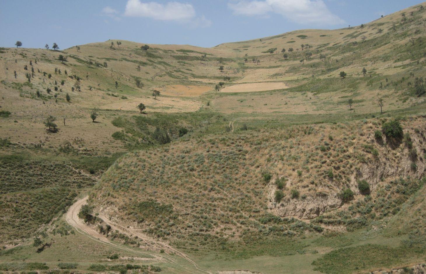
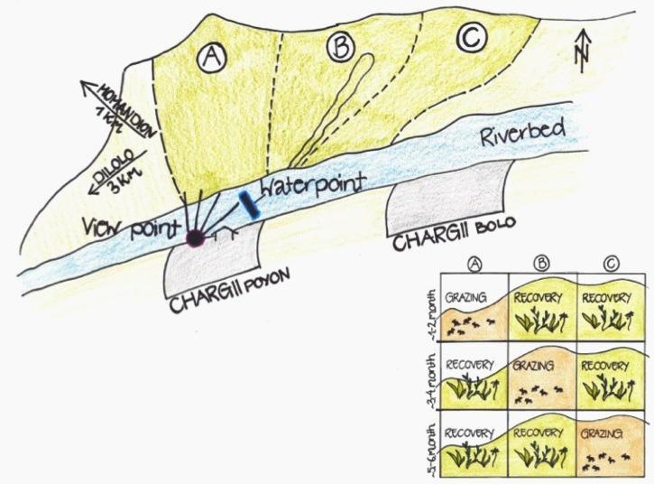
A riverbed divides the pasture where rotational grazing is practiced with the village Chargii poyon, where the certified land user and owner of the pasture lives. From a view point nearby his house, he has a good view on and hence a good control over the pasture area. This allows him to keep intrusive livestock outside, having a limited number of grazing livestock in the pasture. The area encompasses 119 ha, from which 5 ha are rented out as crop land.
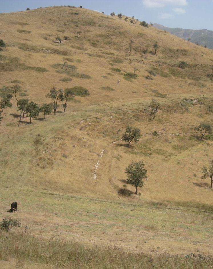
Land tenure conflicts about this pasture existed over many years, because there wasn’t declared any owner. The certified land user of Chargii poyon claims to possess the pasture since 1999. It is unclear how he got the land transferred. Being aware of the ongoing degradation of this land, the certified land user divided the area into 3 parts and introduced controlled grazing in 2007. While one part is being grazed the other two lie fallow. After one to two months of grazing in one area, the herds move to the next area. The rotation phases depend on the availability of grass. In June 2012, at the moment of documentation, there were 145 cows and some 30 goats and sheep. The number of animals is varying seasonally, with a higher amount of animals in summer than in winter. Compared to other pastures in summer, more grass in available on the pasture with rotational grazing. In winter grass availability is comparable between the pastures. This may explain why a higher number of livestock is recorded on the pasture with rotational grazing in summer.
The pasture is controlled by the farmer and further 4 people to avoid livestock intrusion.
In a seminar organized by Caritas Switzerland, the farmer learned about increasing long-term productivity of pastures by vegetation recovery. The idea of pasture rotation convinced him in order to raise productivity on long-term. The main reasons for changing the pasture management were the advanced stage of deforestation, increasing overgrazing, and the additional source to get the land taxes paid. The management of the pasture by rotational grazing on three areas allows the non-grazed areas to rest and recover. Less grazed and trampled areas result in an increase of the vegetation cover and thus to higher fodder quality, as well as increased soil stability and therefore a reduced risk of disasters, such as floods.
The farmer expected that the implementation of land conservation measures would stop the on-going pasture degradation and would assure long-term and sustainable use of the land. Despite the rotating system, the grazing land is still overgrazed and shows signs indicating moderate erosion, but it is less degraded than other pastures in the watershed. The area being the most far away from the settlement is in best conditions. The closer to the riverbed the more degraded and eroded the pasture is.
Additional measures are necessary to reduce soil erosion and gully formation in the area
Livestock owners have to pay a fee to the farmer for grazing cows, but not for grazing sheep and goats. The amount of the fee depends on the provenance of the herder. Fees vary greatly between the villages. Because of solidarity, Chargii villagers pay much less than herders from villages located further away. Momandion villagers pay 3 times, Dilolo villagers even 9 times more than Chargi villagers. But the certified land user claims to be flexible in the amount of fees for poor herders. He has to pay taxes to the government for the property and salary to the surveillants. If more money is available, also generated by the fees, the certified land user claims to invest a part of the money into the pasture. He would like to build another water point and to plant trees in the upper area. Livestock could graze in more remote areas which would reduce the pressure on the pastures in the lower area and decrease the soil compaction.
The pasture is located in the middle zone of the Obishur watershed and on the foothill above the riverbed plain. This pasture, located between the villages of Chargi poyon, Chargi bolo and Momandion and not far from Dilolo village, is a reachable place for many livestock of private households. In the riverbed, the only water point is installed where livestock is watered at midday. Due to tree cutting in the past, only a few shady places exist. Vegetation cover varies depending on the exposition of the slopes and the accessibility of the pasture. North-facing slopes have a more abundant vegetation cover. Some flanks are difficult to reach because of dense thorn bushes. A big gully, hardly accessible by livestock, is about to be covered again by naturally re-growing bushes and trees. Nevertheless, signs of erosion and rill building can be observed. Due to the closeness to the villages and to the pressure on natural resources it is crucial to sustain a controlled pasture management.
2.3 Fotos da tecnologia
Galeria de Mídias
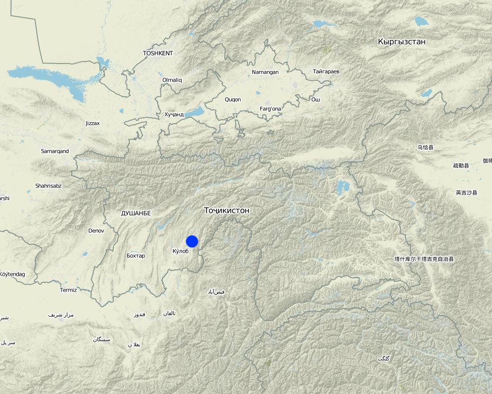
2.5 País/região/locais onde a tecnologia foi aplicada e que estão cobertos nesta avaliação
País:
Tajiquistão
Região/Estado/Província:
Khatlon, Tajikistan
Especificação adicional de localização:
Muminabad
Especifique a difusão da tecnologia:
- Uniformemente difundida numa área
Se a área precisa não for conhecida, indicar a área aproximada coberta:
- 1-10 km2
Comentários:
Total area covered by the SLM Technology is 1.14 km2.
Total area is 119 ha, but 5 ha out of it are rented for cropping
Map
×2.6 Data da implementação
Caso o ano exato seja desconhecido, indique a data aproximada:
- menos de 10 anos atrás (recentemente)
2.7 Introdução da tecnologia
Especifique como a tecnologia foi introduzida:
- através de projetos/intervenções externas
Comentários (tipos de projeto, etc.):
Idea of how to improve ground cover was initiated by a workshop from Caritas, but the rotational grazing was introduced by the farmer himself in 2007
3. Classificação da tecnologia de GST
3.1 Principal/principais finalidade(s) da tecnologia
- Melhora a produção
- Reduz, previne, recupera a degradação do solo
3.2 Tipo(s) atualizado(s) de uso da terra onde a tecnologia foi aplicada

Pastagem
Pastagem extensiva:
- Pastoralismo semi-nômade
- rotational grazing
Tipo de animal:
- caprinos
- ovelhas
- cows
Comentários:
Livestock density (if relevant):
> 100 LU /km2
Major land use problems (compiler’s opinion): Overgrazed pasture with frequent big gullies, rills and trampled areas. Almost complete deforestation of the grazing land.
Major land use problems (land users’ perception): Lack of water availability and water points for grazing livestock. Gradual degradation and erosion of the pasture which has to be stopped.
Grazingland comments: Rotation within 119 ha of grazing land
3.4 Abastecimento de água
Abastecimento de água para a terra na qual a tecnologia é aplicada:
- Precipitação natural
3.5 Grupo de GST ao qual pertence a tecnologia
- sistema rotativo (rotação de culturas, pousios, cultivo itinerante)
- Gestão de pastoralismo e pastagem
3.6 Medidas de GST contendo a tecnologia

Medidas de gestão
- M2: Mudança de gestão/nível de intensidade
3.7 Principais tipos de degradação da terra abordados pela tecnologia

Erosão do solo pela água
- Wt: Perda do solo superficial/erosão de superfície
- Wg: Erosão por ravinas/ravinamento

Deteriorização química do solo
- Cn: declínio de fertilidade e teor reduzido de matéria orgânica (não causado pela erosão)

Deteriorização física do solo
- Pc: Compactação

Degradação biológica
- Bc: redução da cobertura vegetal
Comentários:
Main causes of degradation: overgrazing, governance / institutional (No/ Insufficient management planning and control), livestock pressure (Due to subsistence of the population)
Secondary causes of degradation: deforestation / removal of natural vegetation (incl. forest fires), disturbance of water cycle (infiltration / runoff) (impact of overgrazing and deforestation), education, access to knowledge and support services
3.8 Redução, prevenção ou recuperação da degradação do solo
Especifique o objetivo da tecnologia em relação a degradação da terra:
- Reduzir a degradação do solo
- Recuperar/reabilitar solo severamente degradado
4. Especificações técnicas, implementação de atividades, entradas e custos
4.1 Desenho técnico da tecnologia
Especificações técnicas (relacionada ao desenho técnico):
The hilly pasture of 114 ha in total is divided more or less vertically in 3 areas. In each area, the pasture between the ridge and the riverbed is covered. After having grazed one area for approximately one to two months, the herd moves to the next part. This means that two areas rest and grasses recover, while one is being grazed.
Location: Chargii poyon. Muminobod, Kathlon, Tajikistan
Technical knowledge required for field staff / advisors: low (When benefits of pasture management are known and understood, high technical knowledge isn't required)
Technical knowledge required for land users: low (When benefits of pasture management are known and understood, high technical knowledge isn't required)
Main technical functions: control of concentrated runoff: impede / retard, control of concentrated runoff: drain / divert, improvement of ground cover, increase of infiltration
Secondary technical functions: increase of surface roughness, improvement of surface structure (crusting, sealing), improvement of topsoil structure (compaction), stabilisation of soil (eg by tree roots against land slides), increase in organic matter, increase / maintain water stored in soil, sediment retention / trapping, sediment harvesting
Change of land use practices / intensity level: In 2007 controlled and rotational grazing was introduced where no pasture management existed before
Autor:
Malgorzata Conder
4.2 Informação geral em relação ao cálculo de entradas e custos
Especifique a moeda utilizada para os cálculos de custo:
- USD
Indique a média salarial da mão-de-obra contratada por dia:
12.40
4.3 Atividades de implantação
| Atividade | Periodicidade (estação do ano) | |
|---|---|---|
| 1. | Introduction/information of pasture management among the herders | once in 2007 |
4.4 Custos e entradas necessárias para a implantação
| Especifique a entrada | Unidade | Quantidade | Custos por unidade | Custos totais por entrada | % dos custos arcados pelos usuários da terra | |
|---|---|---|---|---|---|---|
| Mão-de-obra | Introduction/information of pasture management among the herders | - | 1,0 |
Comentários:
Duration of establishment phase: 1 month(s)
4.5 Atividades recorrentes/manutenção
| Atividade | Periodicidade/frequência | |
|---|---|---|
| 1. | Salary for 5 people to guard pasture and herders: Monthly salary 70 Som/pers, pers d unknown | every day, from spring until autumn |
| 2. | Annual Rent | once a year |
4.6 Custos e entradas necessárias pata a manutenção/atividades recorrentes (por ano)
| Especifique a entrada | Unidade | Quantidade | Custos por unidade | Custos totais por entrada | % dos custos arcados pelos usuários da terra | |
|---|---|---|---|---|---|---|
| Mão-de-obra | Guarding pasture and herders | Persons/6months | 5,0 | 86,96 | 434,8 | 100,0 |
| Outros | Annual rent | ha | 114,0 | 1,359649 | 155,0 | 100,0 |
| Custos totais para a manutenção da tecnologia | 589,8 | |||||
| Custos totais de manutenção da Tecnologia em USD | 589,8 | |||||
Comentários:
Costs which concern the information transfer to the herders is not calculated, as it is done informally. Only guardening by the employed people is monetarised.
4.7 Fatores mais importantes que afetam os custos
Descreva os fatores mais determinantes que afetam os custos:
The farmer already owns the land user certificate for the property and only has to pay annual taxes and the people who control the pasture. He covers these costs with the rent he gets for the grazing livestock.
5. Ambiente natural e humano
5.1 Clima
Precipitação pluviométrica anual
- <250 mm
- 251-500 mm
- 501-750 mm
- 751-1.000 mm
- 1.001-1.500 mm
- 1.501-2.000 mm
- 2.001-3.000 mm
- 3.001-4.000 mm
- > 4.000 mm
Especificações/comentários sobre a pluviosidade:
Totally 800mm: 700mm in winter-spring, July-Sept dry season (At 1200mm asl, wheater station Muminabad). Precipitation increases 60mm per 100m of altitude in average.
Zona agroclimática
- Subúmido
Thermal climate class: temperate
5.2 Topografia
Declividade média:
- Plano (0-2%)
- Suave ondulado (3-5%)
- Ondulado (6-10%)
- Moderadamente ondulado (11-15%)
- Forte ondulado (16-30%)
- Montanhoso (31-60%)
- Escarpado (>60%)
Formas de relevo:
- Planalto/planície
- Cumes
- Encosta de serra
- Encosta de morro
- Sopés
- Fundos de vale
Zona de altitude:
- 0-100 m s.n.m.
- 101-500 m s.n.m.
- 501-1.000 m s.n.m.
- 1.001-1.500 m s.n.m.
- 1.501-2.000 m s.n.m.
- 2.001-2.500 m s.n.m.
- 2.501-3.000 m s.n.m.
- 3.001-4.000 m s.n.m.
- > 4.000 m s.n.m.
Comentários e outras especificações sobre a topografia:
Slopes on average: Some flanks over 40%
Slopes on average: Also rolling
5.3 Solos
Profundidade do solo em média:
- Muito raso (0-20 cm)
- Raso (21-50 cm)
- Moderadamente profundo (51-80 cm)
- Profundo (81-120 cm)
- Muito profundo (>120 cm)
Textura do solo (solo superficial):
- Médio (limoso, siltoso)
- Fino/pesado (argila)
Matéria orgânica do solo superficial:
- Baixo (<1%)
Caso disponível anexe a descrição completa do solo ou especifique as informações disponíveis, p. ex. tipo de solo, PH/acidez do solo, nitrogênio, capacidade de troca catiônica, salinidade, etc.
Soil fertility: Low-medium
Soil drainage / infiltration: Poor-medium
Soil water storage capacity: Low
5.4 Disponibilidade e qualidade de água
Lençol freático:
5-50 m
Disponibilidade de água de superfície:
Precário/nenhum
Qualidade da água (não tratada):
Água potável precária (tratamento necessário)
Comentários e outras especificações sobre a qualidade e a quantidade da água:
Water quality (untreated): For livestock, surface water in spring (because of snow melting and rainfall), in summer ground water at one water point
5.5 Biodiversidade
Diversidade de espécies:
- Baixo
Comentários e outras especificações sobre biodiversidade:
Tree cutting, due to grazing more and more uneatable species
5.6 Características dos usuários da terra que utilizam a tecnologia
Orientação de mercado do sistema de produção:
- Subsistência (autoabastecimento)
Rendimento não agrícola:
- Menos de 10% de toda renda
Nível relativo de riqueza:
- Rico
Indivíduos ou grupos:
- Indivíduo/unidade familiar
Gênero:
- Homens
Indique outras características relevantes dos usuários da terra:
Land users applying the Technology are mainly Leaders / privileged
Difference in the involvement of women and men: Men are taking decisions and administrating the property whereas women are working on the field. Privileged land user because he owns a big area.
Population density: 100-200 persons/km2
Annual population growth: 1% - 2% (Farmer owns a big property of 119 ha).
Off-farm income specification: Additionally bee-keeping
5.7 Área média de terrenos utilizados pelos usuários de terrenos que aplicam a Tecnologia
- < 0,5 ha
- 0,5-1 ha
- 1-2 ha
- 2-5 ha
- 5-15 ha
- 15-50 ha
- 50-100 ha
- 100-500 ha
- 500-1.000 ha
- 1.000-10.000 ha
- > 10.000 ha
É considerado pequena, média ou grande escala (referente ao contexto local)?
- Média escala
Comentários:
3.2 ha if 7.7 pers/household for totally 4100 ha pasture
5.8 Propriedade de terra, direitos de uso da terra e de uso da água
Propriedade da terra:
- Estado
Direitos do uso da terra:
- Arrendado
Direitos do uso da água:
- Comunitário (organizado)
Comentários:
Land ownership is based on the land user certificate conferred by the government.
5.9 Acesso a serviços e infraestrutura
Saúde:
- Pobre
- Moderado
- Bom
Educação:
- Pobre
- Moderado
- Bom
Assistência técnica:
- Pobre
- Moderado
- Bom
Emprego (p. ex. não agrícola):
- Pobre
- Moderado
- Bom
Mercados:
- Pobre
- Moderado
- Bom
Energia:
- Pobre
- Moderado
- Bom
Vias e transporte:
- Pobre
- Moderado
- Bom
Água potável e saneamento:
- Pobre
- Moderado
- Bom
Serviços financeiros:
- Pobre
- Moderado
- Bom
6. Impactos e declarações finais
6.1 Impactos no local mostrados pela tecnologia
Impactos socioeconômicos
Produção
Área de produção
Gestão de terra
Renda e custos
Rendimento agrícola
Disparidades econômicas
Carga de trabalho
Impactos socioculturais
Segurança alimentar/auto-suficiência
Estado de saúde
Instituições comunitárias
Atenuação de conflitos
Livelihoods and human well-being
Comentários/especificar:
The farmer possessing the user certificate of the land states that even poor families are allowed to graze their livestock for a low rent and thus this pasture management seems to lead to more equity among the farmers of different economic classes. The better the livestock is fed, the higher the value of livestock and the wealthier the households are. But this statement could not be verified and should be taken with precaution.
Impactos ecológicos
Ciclo hídrico/escoamento
Quantidade de água
Escoamento superficial
Evaporação
Solo
Umidade do solo
Cobertura do solo
Perda de solo
Ressecamento/ selagem do solo
Compactação do solo
Matéria orgânica do solo/carbono abaixo do solo
Biodiversidade: vegetação, animais
Biomassa/carbono acima do solo
Diversidade vegetal
Diversidade de habitat
Outros impactos ecológicos
Hazards towards adverse events
6.2 Impactos externos mostrados pela tecnologia
Cheias de jusante
6.3 Exposição e sensibilidade da tecnologia às mudanças climáticas graduais e extremos/desastres relacionados ao clima (conforme o ponto de vista dos usuários da terra)
Mudança climática gradual
Mudança climática gradual
| Estação do ano | aumento ou diminuição | Como a tecnologia lida com isso? | |
|---|---|---|---|
| Temperatura anual | aumento | bem |
Extremos (desastres) relacionados ao clima
Desastres meteorológicos
| Como a tecnologia lida com isso? | |
|---|---|
| Temporal local | bem |
| Tempestade de vento local | bem |
Desastres climatológicos
| Como a tecnologia lida com isso? | |
|---|---|
| Seca | bem |
Desastres hidrológicos
| Como a tecnologia lida com isso? | |
|---|---|
| Inundação geral (rio) | bem |
Outras consequências relacionadas ao clima
Outras consequências relacionadas ao clima
| Como a tecnologia lida com isso? | |
|---|---|
| Período de crescimento reduzido | não conhecido |
Comentários:
Thanks to a better vegetation cover, the infiltration of rainwater is facilitated which results in an increase in soil moisture and thus to a higher resilience to droughts or higher temperatures.
6.4 Análise do custo-benefício
Como os benefícios se comparam aos custos de implantação (do ponto de vista dos usuários da terra)?
Retornos a curto prazo:
positivo
Retornos a longo prazo:
muito positivo
Como os benefícios se comparam aos custos recorrentes/de manutenção(do ponto de vista dos usuários da terra)?
Retornos a curto prazo:
positivo
Retornos a longo prazo:
muito positivo
Comentários:
Establishment and maintenance cost are low. Input consists mainly of the establishment of a pasture management which is based on dissemination of knowledge and information
6.5 Adoção da tecnologia
- casos isolados/experimental
Se disponível, determine a quantidade (número de unidades familiares e/ou área abordada):
1 Household
De todos aqueles que adotaram a Tecnologia, quantos o fizeram espontaneamente, ou seja, sem receber nenhum incentivo/ pagamento material?
- 91-100%
Comentários:
1 land user families have adopted the Technology without any external material support
At the time of documentation it wasn't known if there exist other land users with a similar technology. There are more farmers grazing on that rotational pasture than in the very beginning.
Precondition is a big grazing land property, but only a small amount of farmers do own such a property.
6.7 Pontos fortes/vantagens/oportunidades da tecnologia
| Pontos fortes/vantagens/oportunidades na visão do usuário da terra |
|---|
| Equity amongst the farmers through flexible renting prices |
| Pontos fortes/vantagens/oportunidades na visão do/a compilador/a ou de outra pessoa capacitada |
|---|
| No high establishment and maintenance cost |
| No high physical inputs required |
| Economic (better fodder quality) and ecological benefits (grass recovery, erosion reduction) can be seen as a direct result of pasture rotation |
| It is a good platform to share and spread knowledge of good practices, as over time many farmers come regularly to graze |
6.8 Pontos fracos, desvantagens/riscos da tecnologia e formas de superá-los
| Pontos fracos/desvantagens/riscos na visão do usuário da terra | Como eles podem ser superados? |
|---|---|
| Other cost intensive investments required like building another waterpipe and planting trees |
| Pontos fracos/vantagens/riscos na visão do/a compilador/a ou de outra pessoa capacitada | Como eles podem ser superados? |
|---|---|
| Precondition for such a setup is that one farmer owns the user certificates for a big grazing land, which is unusual. It is not clear how he got the user rights. | Ideally communal grazing land would be divided among several households sharing access to pastures |
| The pasture shows still a lot of signs of erosion and degraded areas. | Less livestock or division into more parts to allow the vegetation cover to rest for a longer time span. Enhance a homogeneous grazing of upper and more distant parts of the pasture. Control if pasture management is adhered consequently. Additional conservation measures such as resowing of specific areas, or fencing of badly degraded areas such as gullies. |
| This system works when there are communal pastures in the surrounding area. On the here documented pasture, less livestock is kept than on communal pastures. This lower density of livestock is not realistic at watersheds level, because it might raise the pressure on land in the other pastures. | Rotating within the grazing land just combats the fact that there is too much livestock compared to the available area |
| It is not clear whether the main motivation of this private pasture is to stop degradation or to collect the renting fees | Elaborate an investment plan showing how the collected fees will be reinvested into grazing land infrastructure and how much is taken for reimbursing the efforts of the certified land user. |
| It is not known whether the different fee levels according to the herders provenance does not create discontentment | Transparent price structure |
7. Referências e links
7.1 Métodos/fontes de informação
- visitas de campo, pesquisas de campo
- entrevistas com usuários de terras
Quando os dados foram compilados (no campo)?
03/09/2012
Links e módulos
Expandir tudo Recolher tudoLinks
Não há links
Módulos
Não há módulos