Area enclosures for protection of riverine ecosystem and regeneration of cut and carry materials. [República Unida da Tanzânia]
- Criação:
- Atualização:
- Compilador/a: ALLAN BUBELWA
- Editor: –
- Revisores: Fabian Ottiger, Alexandra Gavilano
Eneo lililotengwa na kwa ajili hifadhi ya mto na kuvuna malisho na matandazo
technologies_1607 - República Unida da Tanzânia
Veja as seções
Expandir tudo Recolher tudo1. Informação geral
1.2 Detalhes do contato das pessoas capacitadas e instituições envolvidas na avaliação e documentação da tecnologia
Especialista em GST:
Member of the district council:
Egidius Pancras
Missenyi Disrict Council Kagera Tanzania
República Unida da Tanzânia
Nome da(s) instituição(ões) que facilitou(ram) a documentação/ avaliação da Tecnologia (se relevante)
Bukoba district council (Bukoba district council) - República Unida da TanzâniaNome da(s) instituição(ões) que facilitou(ram) a documentação/ avaliação da Tecnologia (se relevante)
Missenyi District Council (Missenyi District Council) - República Unida da Tanzânia1.3 Condições em relação ao uso da informação documentada através de WOCAT
O compilador e a(s) pessoa(s) capacitada(s) aceitam as condições relativas ao uso de dados documentados através do WOCAT:
Sim
1.4 Declaração de sustentabilidade da tecnologia descrita
A tecnologia descrita aqui é problemática em relação a degradação da terra de forma que não pode ser declarada uma tecnologia de gestão sustentável de terra?
Não
1.5 Referência ao(s) questionário(s) sobre abordagens GST (documentado(s) usando WOCAT)
Active participation of herder leader (WAKONDO) in management … [República Unida da Tanzânia]
Prevention and mitigation of the grazing land and riverine ecosystems through mandatory grassroots meetings, law enforcement and active participation and empowerment of herder leaders’ (masters of the most resource destructive group)
- Compilador/a: ALLAN BUBELWA
2. Descrição da tecnologia de GST
2.1 Descrição curta da tecnologia
Definição da tecnologia:
Area enclosures for protection of riverine ecosystem and purposeful regeneration of mulching and pasture materials for cut and carry
2.2 Descrição detalhada da tecnologia
Descrição:
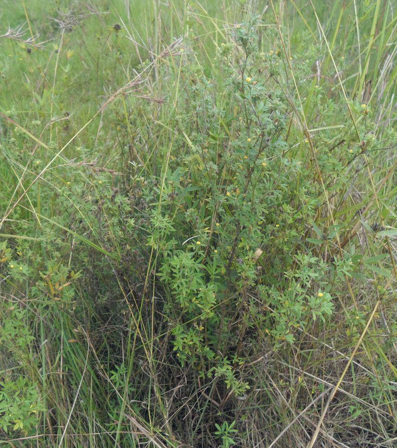
Area enclosure is done in low grazing range lands of average slope 2 – 5%. Enclosure is done by demarcating the fragile land that has direct impact to the riverine ecosystem. The land is exposed to degradation through overgrazing and soil compaction by livestock, bush fire, river bank erosion and reduced quality of pasture spps. Demarcation is done by planting trees in identified area situated about 300 meters from the riverine buffer zone. The preferred plants are Ficus thonigii. The average space between trees is 2 meters. Physical enclosure is supported and enhanced by use of protective bylaws. Reseeding of nutritious pasture species is also done and the area is left under protection for growth and regeneration of mulch, pastures and other vegetation to take place. The common pasture species reseeded are Leucaena spp, cannavaria brazile, clitoria tenatea, sesbania sesban, stylothensis, cajanus cajan, chloris gayana, branchalia spps . Direct grazing is prohibited and mulch and pasture materials are accessed through controlled and organized cut and carry.
Area enclosure is meant for rehabilitation of the riverine ecosystem and prevention of further degradation. Mulch and high nutritious pasture materials that are accessed through organized cut and carry procedures improve crop and animal productivity and have both direct and indirect impact to diversification of income sources and thus play significant role in putting the triple win solution into reality.
Purpose of the Technology: Purpose: 1) To improve vegetative cover, reduce soil erosion and prevent and rehabilitate degradation of the riverine ecosystem 2) Ensure sustainable availability and accessibility of mulch and nutritious pasture that are need for increased crop and livestock productivity 3) Promote use of environmental friendly exploitation of land resources (i.e. mulch, pasture, grass carpeting and other materials) and 4) Promote direct and indirect diversification of income sources.
Establishment / maintenance activities and inputs: Establishment and recurrent activities includes: area identification and measurement; slashing and land preparation for boundary tree planting and pasture reseeding; collection of planting materials and planting along defined boundaries for demarcation; procurement of seed and reseeding of nutritious and palatable pasture species; selective weeding; area reshaping and gap filling.
Natural / human environment: Bio-physically the area is semi natural grassland with grasses and shrubs trees. The technology is a combination of management and vegetative measure (area enclosure, demarcation using ficus thonigii and reseeding of nutritious pasture). Climatic zone is sub humid with 210 length of growing period (LGP). Slope category is gentle lying between 2-5%. Soil texture is fine heavy (clay) with medium soil depth.
Social economic wise the area is dominated by handy tools typology of mechanization. Production system is mixed (both for subsistence and commercial purposes). Inputs used includes tools (hand hoe, machete, sickles, spade and mattock), light and heavy labour, pasture seeds and tree planting materials with average annual costs of 1084.3 USD per hectare. Land ownership in technological area is communal.
2.3 Fotos da tecnologia
Galeria de Mídias
2.5 País/região/locais onde a tecnologia foi aplicada e que estão cobertos nesta avaliação
País:
República Unida da Tanzânia
Região/Estado/Província:
Tanzania/Kagera
Especificação adicional de localização:
Missenyi distict/Minziro ward/Minziro village
Especifique a difusão da tecnologia:
- Uniformemente difundida numa área
Se a área precisa não for conhecida, indicar a área aproximada coberta:
- < 0,1 km2 (10 ha)
Comentários:
Includes enclosed and demarcated area closer and around the riverine ecosystem.
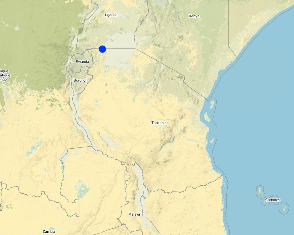
Map
×2.6 Data da implementação
Caso o ano exato seja desconhecido, indique a data aproximada:
- menos de 10 anos atrás (recentemente)
2.7 Introdução da tecnologia
Especifique como a tecnologia foi introduzida:
- atráves de inovação dos usuários da terra
- através de projetos/intervenções externas
Comentários (tipos de projeto, etc.):
The technology is a result of the recent SLM participatory dialogues made between land users and SLM specialist (external experts). In these dialogues both endogenous and technical knowledge based were given equal weight and were combined in a complementary manner. Land users alos were empowered to take self initiative and ownership of the decision making process.
3. Classificação da tecnologia de GST
3.1 Principal/principais finalidade(s) da tecnologia
- Reduz, previne, recupera a degradação do solo
- Preserva ecossistema
- Preservar/melhorar a biodiversidade
3.2 Tipo(s) atualizado(s) de uso da terra onde a tecnologia foi aplicada
Uso do solo misturado dentro da mesma unidade de terra:
Sim
Especificar o uso misto da terra (culturas/ pastoreio/ árvores):
- Silvipecuária

Terra de cultivo
Número de estações de cultivo por ano:
- 2
Especifique:
Longest growing period in days: 120, Longest growing period from month to month: September to December Second longest growing period in days: 90 Second longest growing period from month to month: March to May

Pastagem
Pastagem extensiva:
- Nomadismo
- Pastoralismo semi-nômade
Pastagem intensiva/produção de forragem:
- Semiestabulação/sem pastagem
Tipo de animal:
- caprinos
- ovelhas

Floresta/bosques
- Ficus thonigii
Comentários:
Livestock density (if relevant):
50-100 LU /km2
Major land use problems (compiler’s opinion): Soil erosion due to downstream run off exacerbated by loss of vegetation cover due to bush fire and soil compaction caused by overgrazing, degradation of the riverine ecosystem caused by River bank erosion, land bareness and exposure to direct sunlight and excessive unproductive loss of both green and blue water.
Major land use problems (land users’ perception): River pollution, erosion of the river bank, land bareness and reduction of mulching and pasture materials.
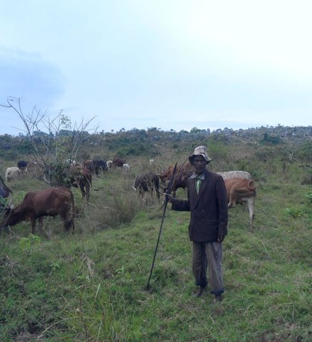
Nomadism: People with large herd of animal move with their animals in search of adequate pasture
Semi-nomadism / pastoralism: Exercised with people with few stock.
Cut-and-carry/ zero grazing: done by farmers who usuall keep dairy goats and cattles.
Grazingland comments: Area enclosure is largely meant to control land degradation of the riverine ecosystem through overgrazing by people who own large number of stocks at the same time promote organized, sustainable and environmental friendly exploitation of the fragile land lands (e.g. controlled cut and carry rather than direct grazing in the riverine ecosystem).
3.4 Abastecimento de água
Abastecimento de água para a terra na qual a tecnologia é aplicada:
- Precipitação natural
3.5 Grupo de GST ao qual pertence a tecnologia
- Reserva ( suspensão do uso, apoio à recuperação)
3.6 Medidas de GST contendo a tecnologia

Medidas vegetativas
- V2: gramíneas e plantas herbáceas perenes

Medidas de gestão
- M7: Outros
Comentários:
Main measures: vegetative measures, management measures
Specification of other management measures: Area enclosure to promote vegetative regeneration and organized use
Type of vegetative measures: aligned: -along boundary, scattered / dispersed
3.7 Principais tipos de degradação da terra abordados pela tecnologia

Erosão do solo pela água
- Wr: erosão das margens

Deteriorização física do solo
- Pc: Compactação

Degradação biológica
- Bc: redução da cobertura vegetal

Degradação da água
- Hs: mudança na quantidade de água de superfície
Comentários:
Main causes of degradation: soil management (Compaction due to overstocking, accerated runoff and erosion.), crop management (annual, perennial, tree/shrub) (Reduction of mulching and pasture materials), deforestation / removal of natural vegetation (incl. forest fires) (Rampant bush fire), over-exploitation of vegetation for domestic use (Un0rganize exploitation of mulching materials), overgrazing (Uncontrolled grazing), disturbance of water cycle (infiltration / runoff) (Loss of green water through unproductive evaporation and blue water through ruoff as well as evaporation), population pressure (Exessive eploitation of the grassland and forests in the riverine ecosystem), poverty / wealth (Reliance on wood as the sole source of fuel), education, access to knowledge and support services (Inadequate acess to extension service due to shortage of extension staff), governance / institutional (Weak and inactive institutions to deal with environmental issues)
Secondary causes of degradation: change in temperature (Climatic change and variability due to green gas emmision caused by bush fire), change of seasonal rainfall (Climatic change and variability due to green gas emmision caused by bush fire), Heavy / extreme rainfall (intensity/amounts) (Climatic change and variability due to green gas emmision caused by bush fire), droughts (Climatic change and variability due to green gas emmision caused by bush fire)
3.8 Redução, prevenção ou recuperação da degradação do solo
Especifique o objetivo da tecnologia em relação a degradação da terra:
- Reduzir a degradação do solo
- Recuperar/reabilitar solo severamente degradado
4. Especificações técnicas, implementação de atividades, entradas e custos
4.1 Desenho técnico da tecnologia
Especificações técnicas (relacionada ao desenho técnico):
Technical knowledge required for field staff / advisors: moderate (Is simply retraining on some principles of sustainable land management, law and rules guiding the fragile ecosystems, participatory training skills and grassroots facilitation skills.)
Technical knowledge required for land users: moderate (Largely exposure to act and policies guiding the fragile ecosystems and learning by doing on the job,)
Main technical functions: control of raindrop splash, control of dispersed runoff: impede / retard, control of concentrated runoff: impede / retard, improvement of ground cover, improvement of topsoil structure (compaction), stabilisation of soil (eg by tree roots against land slides), increase / maintain water stored in soil, improvement of water quality, buffering / filtering water, sediment retention / trapping, sediment harvesting, promotion of vegetation species and varieties (quality, eg palatable fodder)
Aligned: -along boundary
Vegetative material: T : trees / shrubs
Number of plants per (ha): 400
Vertical interval between rows / strips / blocks (m): 1 m
Spacing between rows / strips / blocks (m): 1 m
Vertical interval within rows / strips / blocks (m): 1 m
Width within rows / strips / blocks (m): 1 m
Scattered / dispersed
Vegetative material: T : trees / shrubs, G : grass
Number of plants per (ha): various
Vertical interval between rows / strips / blocks (m): various
Spacing between rows / strips / blocks (m): various
Vertical interval within rows / strips / blocks (m): various
Width within rows / strips / blocks (m): various
Trees/ shrubs species: ficus thonigii planted arround the boundary and leguminous pasture shrubs planted within the area (stlothensis, lucaena spps)
Grass species: Randomly planted (chloris gayana, desmodium spp and Calliandra)
Slope (which determines the spacing indicated above): 2 - 5%%
Gradient along the rows / strips: 2 - 5%%
Change of land use practices / intensity level: Introduction of organized cut and carry exploitation of mulching and pasture materials
Other type of management: Boundary enclosure, law enforcement
4.2 Informação geral em relação ao cálculo de entradas e custos
Outro/moeda nacional (especifique):
Tanzanian shillings
Se for relevante, indique a taxa de câmbio do USD para moeda local (por exemplo, 1 USD = 79,9 Real): 1 USD =:
1700,0
Indique a média salarial da mão-de-obra contratada por dia:
1.12
4.3 Atividades de implantação
| Atividade | Periodicidade (estação do ano) | |
|---|---|---|
| 1. | Site/boundary identification | October |
| 2. | Site preparation for reseeding and demarcation (slashing, selective tilling, hole digging) | October |
| 3. | Planting of demarcation trees, leguminous shrubs and grass pasture | November |
| 4. | Fertilizer application (DAP) | Once |
| 5. | Meeting on awareness creation and formalization of the practice (change of resource use practice) | once |
4.4 Custos e entradas necessárias para a implantação
| Especifique a entrada | Unidade | Quantidade | Custos por unidade | Custos totais por entrada | % dos custos arcados pelos usuários da terra | |
|---|---|---|---|---|---|---|
| Mão-de-obra | Site/boundary identification | Mandays | 15,0 | 1,13333 | 17,0 | 100,0 |
| Mão-de-obra | Site preparation for reseeding and demarcation (slashing, selective tilling, hole digging) | Mandays | 15,0 | 3,9213 | 58,82 | |
| Mão-de-obra | Planting of demarcation trees, leguminous shrubs and grass pasture | Mandays | 15,0 | 3,9213 | 58,82 | |
| Mão-de-obra | Fertilizer application (DAP) | Mandays | 15,0 | 1,13333 | 17,0 | |
| Equipamento | Tools | Number | 5,0 | 3,0 | 15,0 | 100,0 |
| Material vegetal | Seeds | ha | 1,0 | 235,29 | 235,29 | |
| Material vegetal | Seedlings | ha | 1,0 | 117,65 | 117,65 | |
| Fertilizantes e biocidas | Fertilizer | kg | 125,0 | 0,588 | 73,5 | |
| Outros | Meeting on awareness creation and formalization of the practice (change of resource use practice) | Mandays | 15,0 | 3,9213 | 58,82 | 100,0 |
| Custos totais para a implantação da tecnologia | 651,9 | |||||
| Custos totais para o estabelecimento da Tecnologia em USD | 0,38 | |||||
Comentários:
Duration of establishment phase: 2 month(s)
4.5 Atividades recorrentes/manutenção
| Atividade | Periodicidade/frequência | |
|---|---|---|
| 1. | Selective weeding and gap filling | Once |
| 2. | Supervision and monitoring | monthly |
| 3. | Organized cut and carry of Mulching and pasture materials | Weekly |
| 4. | monitoring area closure and organized cut and carry | Weekly |
4.6 Custos e entradas necessárias pata a manutenção/atividades recorrentes (por ano)
| Especifique a entrada | Unidade | Quantidade | Custos por unidade | Custos totais por entrada | % dos custos arcados pelos usuários da terra | |
|---|---|---|---|---|---|---|
| Mão-de-obra | Selective weeding and gap filling | Mandays | 15,0 | 1,76466 | 26,47 | 100,0 |
| Mão-de-obra | Supervision and monitoring | Mandays | 15,0 | 3,53 | 52,95 | 100,0 |
| Mão-de-obra | Organized cut and carry of Mulching and pasture materials | Mandays | 10,0 | 17,647 | 176,47 | 100,0 |
| Mão-de-obra | monitoring area closure and organized cut and carry | Mandays | 10,0 | 17,647 | 176,47 | 100,0 |
| Custos totais para a manutenção da tecnologia | 432,36 | |||||
| Custos totais de manutenção da Tecnologia em USD | 0,25 | |||||
Comentários:
Machinery/ tools: machete and sickles.
The costs were calculated per unit of ha as per 13/06/2014.
4.7 Fatores mais importantes que afetam os custos
Descreva os fatores mais determinantes que afetam os custos:
labour is the most determinant factor.
5. Ambiente natural e humano
5.1 Clima
Precipitação pluviométrica anual
- <250 mm
- 251-500 mm
- 501-750 mm
- 751-1.000 mm
- 1.001-1.500 mm
- 1.501-2.000 mm
- 2.001-3.000 mm
- 3.001-4.000 mm
- > 4.000 mm
Especificações/comentários sobre a pluviosidade:
Short rains (september to December), March to May long rains. Length of dry periods January, February, June, July and August.
Zona agroclimática
- Subúmido
Thermal climate class: tropics. Temperature grater than 20°C, LGP is 210 days
5.2 Topografia
Declividade média:
- Plano (0-2%)
- Suave ondulado (3-5%)
- Ondulado (6-10%)
- Moderadamente ondulado (11-15%)
- Forte ondulado (16-30%)
- Montanhoso (31-60%)
- Escarpado (>60%)
Formas de relevo:
- Planalto/planície
- Cumes
- Encosta de serra
- Encosta de morro
- Sopés
- Fundos de vale
Zona de altitude:
- 0-100 m s.n.m.
- 101-500 m s.n.m.
- 501-1.000 m s.n.m.
- 1.001-1.500 m s.n.m.
- 1.501-2.000 m s.n.m.
- 2.001-2.500 m s.n.m.
- 2.501-3.000 m s.n.m.
- 3.001-4.000 m s.n.m.
- > 4.000 m s.n.m.
Comentários e outras especificações sobre a topografia:
Landforms: Plateau/plains (ranked 1, is largely applied in extended cancave lower range land pouring water to the river) and footslopes (ranked 2, partly includes the convex the convex hill slopes)
Slopes on average: Gentle (The area is largely extended gentle sloppy lower range land plateau receiving water from the the upper landscape and draining into the lower Ngono river which drains into Kagera river)
5.3 Solos
Profundidade do solo em média:
- Muito raso (0-20 cm)
- Raso (21-50 cm)
- Moderadamente profundo (51-80 cm)
- Profundo (81-120 cm)
- Muito profundo (>120 cm)
Textura do solo (solo superficial):
- Grosso/fino (arenoso)
- Fino/pesado (argila)
Matéria orgânica do solo superficial:
- Baixo (<1%)
Caso disponível anexe a descrição completa do solo ou especifique as informações disponíveis, p. ex. tipo de solo, PH/acidez do solo, nitrogênio, capacidade de troca catiônica, salinidade, etc.
Soil depth on average: Moderately deep (ranked 1, The lower range land is moderately deep it receives eroded soil from the upper and mid sloppy landscape) and shallow (ranked 2, largely include the the area between the upper and lower mid landscape)
Soil texture: Coarse/light (ranked 1, the lower side is largely light sandy soil) and fine/heavy (ranked 2, some patches fine clay soil)
Soil fertility: Low (Nutrient eroded by runoff into the river)
Topsoil organic matter: Low (top soil eroded by runoff into the river)
Soil drainage / infiltration: Medium (ranked 1, caused by the dominance of sand soil) and poor (ranked 2, due to trampling by animals)
Soil water storage capacity: Low (due to the dominance of sand soil)
5.4 Disponibilidade e qualidade de água
Lençol freático:
Na superfície
Disponibilidade de água de superfície:
Médio
Qualidade da água (não tratada):
Água potável precária (tratamento necessário)
Comentários e outras especificações sobre a qualidade e a quantidade da água:
Ground water table: On surface (ranked 1, along the flowing river Ngono) and <5m (ranked 2, the area is within the riverine ecosystem)
Availability of surface water: Medium (The main water source is Kagera river with water flows all year round)
Water quality (untreated): Poor drinking water (treatment required, Kagera river receives partly receives water drained from the upper kibanja, Kikamba and other distant places. Kagera river water therefore is contaminated can not be consumed untreated)
5.5 Biodiversidade
Diversidade de espécies:
- Baixo
Comentários e outras especificações sobre biodiversidade:
Overgrazing has left the area with disappearance of some palatable and nutritious pastures, bushfire and deforestation also has disturbed tree and shrub composition and the soil microbiology.
5.6 Características dos usuários da terra que utilizam a tecnologia
Orientação de mercado do sistema de produção:
- misto (subsistência/comercial)
Rendimento não agrícola:
- Menos de 10% de toda renda
Indivíduos ou grupos:
- Indivíduo/unidade familiar
Gênero:
- Mulheres
- Homens
Indique outras características relevantes dos usuários da terra:
Land users applying the Technology are mainly common / average land users
Population density: 50-100 persons/km2
Annual population growth: 1% - 2%
30% of the land users are very rich and own 35% of the land.
60% of the land users are average wealthy and own 50% of the land.
10% of the land users are poor.
and own 15% of the land.
Off-farm income specification: Generally 90% relies on agriculture as their main source of livelihood. Only a few are engaged in off-farm activities like petty trading, kiosk, brick making e.t.c.
Market orientation: Mixed (Livestock are largely kept for domestic use e.g. milk, meat and manure and parlty for commercial purposes)
5.7 Área média de terrenos utilizados pelos usuários de terrenos que aplicam a Tecnologia
- < 0,5 ha
- 0,5-1 ha
- 1-2 ha
- 2-5 ha
- 5-15 ha
- 15-50 ha
- 50-100 ha
- 100-500 ha
- 500-1.000 ha
- 1.000-10.000 ha
- > 10.000 ha
É considerado pequena, média ou grande escala (referente ao contexto local)?
- Pequena escala
Comentários:
There is shortage of grazing land. People with large animal herd move with their animals in search of better pasture.
5.8 Propriedade de terra, direitos de uso da terra e de uso da água
Propriedade da terra:
- Indivíduo, não intitulado
Direitos do uso da terra:
- Indivíduo
Direitos do uso da água:
- Acesso livre (não organizado)
Comentários:
In Tanzania land is a state property. Land use right is largely individual not titled and is acquired through inheritance or purchase through traditional or customary procedures.
5.9 Acesso a serviços e infraestrutura
Saúde:
- Pobre
- Moderado
- Bom
Educação:
- Pobre
- Moderado
- Bom
Assistência técnica:
- Pobre
- Moderado
- Bom
Emprego (p. ex. não agrícola):
- Pobre
- Moderado
- Bom
Mercados:
- Pobre
- Moderado
- Bom
Vias e transporte:
- Pobre
- Moderado
- Bom
Água potável e saneamento:
- Pobre
- Moderado
- Bom
Serviços financeiros:
- Pobre
- Moderado
- Bom
6. Impactos e declarações finais
6.1 Impactos no local mostrados pela tecnologia
Impactos socioeconômicos
Produção
Produção agrícola
Quantidade anterior à GST:
5.0 ton/ha
Quantidade posterior à GST:
6-7.0 ton/ha
Comentários/especificar:
due to the availability and use of mulching by some farmersmaterials
Produção de forragens
Quantidade anterior à GST:
2 acres/annum
Quantidade posterior à GST:
10 acre/annum
Comentários/especificar:
area enclosure and decline of forest fire
Qualidade da forragem
Quantidade anterior à GST:
3
Quantidade posterior à GST:
8
Comentários/especificar:
increase in the number of nutritiuos pasture species due to reseeding
Produção animal
Quantidade anterior à GST:
1200litres/cow/yeer
Quantidade posterior à GST:
2000litres/cow/year
Comentários/especificar:
Contribution of nutritious cut and carry pastures
Renda e custos
Despesas com insumos agrícolas
Quantidade anterior à GST:
high
Quantidade posterior à GST:
low
Comentários/especificar:
availability of manure from animal kept under zore grazing
Diversidade de fontes de rendimento
Quantidade anterior à GST:
low
Quantidade posterior à GST:
high
Comentários/especificar:
Income accrued from sell of mulching and pasture materials.
Impactos socioculturais
Segurança alimentar/auto-suficiência
Quantidade anterior à GST:
low
Quantidade posterior à GST:
high
Comentários/especificar:
improved diet due to varied food availability (avalability of milk)
Instituições comunitárias
Quantidade anterior à GST:
weak
Quantidade posterior à GST:
strong
Comentários/especificar:
empowerment and capacity building of environmental committee.
Conhecimento de GST/ degradação da terra
Quantidade anterior à GST:
low
Quantidade posterior à GST:
high
Comentários/especificar:
Knoledge over controll of riverine resources.
Atenuação de conflitos
Quantidade anterior à GST:
low
Quantidade posterior à GST:
high
Improved livelihoods and human well-being
Comentários/especificar:
The technology has contributed to availability and accessibility to mulching and nutritious pasture that are need for increased crop and livestock productivity. This has both direct and indirect impact on the income of the community and hence livelihood (e.g. ability to meet education and health expenses).
Impactos ecológicos
Ciclo hídrico/escoamento
Quantidade de água
Quantidade anterior à GST:
low
Quantidade posterior à GST:
high
Comentários/especificar:
Reduction in uproductive loss of both green and blue water.
Escoamento superficial
Quantidade anterior à GST:
high
Quantidade posterior à GST:
low
Comentários/especificar:
Resultant of vergetation cover
Evaporação
Quantidade anterior à GST:
high
Quantidade posterior à GST:
low
Comentários/especificar:
Reduce uproductive evaporation due vegetation cover
Solo
Cobertura do solo
Quantidade anterior à GST:
low
Quantidade posterior à GST:
high
Comentários/especificar:
Improved vegetation cover
Perda de solo
Quantidade anterior à GST:
high
Quantidade posterior à GST:
low
Comentários/especificar:
Cotrolled soil erosion due to runoff
Ressecamento/ selagem do solo
Quantidade anterior à GST:
high
Quantidade posterior à GST:
low
Comentários/especificar:
Reduced overgrazing and animla trumpling
Compactação do solo
Quantidade anterior à GST:
high
Quantidade posterior à GST:
low
Comentários/especificar:
Reduced overgrazing and animla trumpling
Biodiversidade: vegetação, animais
Biomassa/carbono acima do solo
Quantidade anterior à GST:
low
Quantidade posterior à GST:
high
Comentários/especificar:
Controlled fire burning
Clima e redução de riscos de desastre
Emissão de carbono e gases de efeito estufa
Quantidade anterior à GST:
high
Quantidade posterior à GST:
low
Comentários/especificar:
Controled bush fire
Risco de incêndio
Quantidade anterior à GST:
high
Quantidade posterior à GST:
low
Comentários/especificar:
harzards due to bush fire but reduced due to enclosure, fire break and use of bylaws.
6.2 Impactos externos mostrados pela tecnologia
Sedimentação a jusante
Quantidade anterior à GST:
high
Quantidade posterior à GST:
low
Comentários/especificar:
Resultant of improved vegetation cover and controlled erosion
Poluição de água subterrânea/rio
Quantidade anterior à GST:
high
Quantidade posterior à GST:
low
Comentários/especificar:
Resultant of improved vegetation cover and controlled erosion
6.3 Exposição e sensibilidade da tecnologia às mudanças climáticas graduais e extremos/desastres relacionados ao clima (conforme o ponto de vista dos usuários da terra)
Mudança climática gradual
Mudança climática gradual
| Estação do ano | aumento ou diminuição | Como a tecnologia lida com isso? | |
|---|---|---|---|
| Temperatura anual | aumento | bem |
Extremos (desastres) relacionados ao clima
Desastres meteorológicos
| Como a tecnologia lida com isso? | |
|---|---|
| Temporal local | não conhecido |
| Tempestade de vento local | não conhecido |
Desastres climatológicos
| Como a tecnologia lida com isso? | |
|---|---|
| Seca | não bem |
Desastres hidrológicos
| Como a tecnologia lida com isso? | |
|---|---|
| Inundação geral (rio) | não conhecido |
Outras consequências relacionadas ao clima
Outras consequências relacionadas ao clima
| Como a tecnologia lida com isso? | |
|---|---|
| Período de crescimento reduzido | não bem |
Comentários:
The technology was modified to become more tolerant through organized cut and carry of mulching and pasture materials.
6.4 Análise do custo-benefício
Como os benefícios se comparam aos custos de implantação (do ponto de vista dos usuários da terra)?
Retornos a curto prazo:
levemente positivo
Retornos a longo prazo:
positivo
Como os benefícios se comparam aos custos recorrentes/de manutenção(do ponto de vista dos usuários da terra)?
Retornos a curto prazo:
levemente positivo
Retornos a longo prazo:
positivo
Comentários:
Mulching and pasture have short maturing period and this causes land users to realize rewards right from the beginning of the technology and the benefit increases more with time.
6.5 Adoção da tecnologia
Comentários:
Comments on acceptance with external material support: The technology is applied only on communally owned area nearby the fragile reverine ecosystem. Implementation is done by empowered community based on and guided with decision reached by the whole community and law reinforcement. Is not based on individual voluntarism and option.
Comments on spontaneous adoption: The technology is applied only on communally owned area nearby the fragile reverine ecosystem. Implementation is done by empowered community based on and guided with decision reached by the whole community and law reinforcement. Is not based on individual voluntarism and option.
There is a strong trend towards spontaneous adoption of the Technology
Comments on adoption trend: As a result of benefit realization of the use of technology, there a growing acceptance and spontaneous adoption by the whole community
6.7 Pontos fortes/vantagens/oportunidades da tecnologia
| Pontos fortes/vantagens/oportunidades na visão do usuário da terra |
|---|
| The technology prevent degradation of the river bank and disappearance of palatable and nutritious pasture |
| Pontos fortes/vantagens/oportunidades na visão do compilador ou de outra pessoa capacitada |
|---|
| Area enclosure complimented with reinforcement of bylaws reduce fire incidences and helps in sequestration of carbon both above and below the ground and reduce the effect of green gas emission. |
| Area enclosure and organized cut and carry feeding ensure availability of feed to animals kept in farm under zero grazing (e.g. dairy goats and cattle) and control unproductive loss of manure. |
| Area enclosure and organized cut and carry feeding ensure availability of mulching materials needed in production of banana and other crops. |
| Promote direct and indirect diversification of income sources to the rural poor. |
6.8 Pontos fracos, desvantagens/riscos da tecnologia e formas de superá-los
| Pontos fracos/desvantagens/riscos na visão do usuário da terra | Como eles podem ser superados? |
|---|---|
| Time consuming and labour heavy especially to environmental committee members. | Device motivation and incentive system at the grassroots. |
| Pontos fracos/vantagens/riscos na visão do compilador ou de outra pessoa capacitada | Como eles podem ser superados? |
|---|---|
| Emergency and dominance of invasive species | Liaise with research to find alternative and beneficial use of invasive species. |
| Needs committed people who can spend their valuable time in promotion of the technology. | Use SLM related incentives and promotion e.g. support with dairy goat to people who actively participate in promotion of the technology (as part of crop livestock integration) . |
| Takes time to inculcate self initiatives and ownership | Systematize and Operationalize into existing systems |
| Needs attitude and behavioral change (is not normal traditional for rural people to cultivate grass). | Encourage change of mindset by enabling farmers understanding of the principle behind pasture establishment. |
7. Referências e links
7.1 Métodos/fontes de informação
- visitas de campo, pesquisas de campo
- entrevistas com usuários de terras
Quando os dados foram compilados (no campo)?
03/06/2014
Links e módulos
Expandir tudo Recolher tudoLinks
Active participation of herder leader (WAKONDO) in management … [República Unida da Tanzânia]
Prevention and mitigation of the grazing land and riverine ecosystems through mandatory grassroots meetings, law enforcement and active participation and empowerment of herder leaders’ (masters of the most resource destructive group)
- Compilador/a: ALLAN BUBELWA
Módulos
Não há módulos