Small-scale dams [Mali]
- Criação:
- Atualização:
- Compilador/a: Dieter Nill
- Editor: –
- Revisores: Deborah Niggli, Alexandra Gavilano
Micro-barrages (French)
technologies_1623 - Mali
Veja as seções
Expandir tudo Recolher tudo1. Informação geral
1.2 Detalhes do contato das pessoas capacitadas e instituições envolvidas na avaliação e documentação da tecnologia
Especialista em GST:
Abdou Sani Mamadou
Programme d’Appui à l’agriculture Productive (PROMAP), Niamey, Niger
Níger
Nome do projeto que facilitou a documentação/avaliação da Tecnologia (se relevante)
Manual of Good Practices in Small Scale Irrigation in the Sahel (GIZ )Nome da(s) instituição(ões) que facilitou(ram) a documentação/ avaliação da Tecnologia (se relevante)
Deutsche Gesellschaft für Internationale Zusammenarbeit (GIZ) - Alemanha1.3 Condições em relação ao uso da informação documentada através de WOCAT
O compilador e a(s) pessoa(s) capacitada(s) aceitam as condições relativas ao uso de dados documentados através do WOCAT:
Sim
1.4 Declaração de sustentabilidade da tecnologia descrita
A tecnologia descrita aqui é problemática em relação a degradação da terra de forma que não pode ser declarada uma tecnologia de gestão sustentável de terra?
Não
2. Descrição da tecnologia de GST
2.1 Descrição curta da tecnologia
Definição da tecnologia:
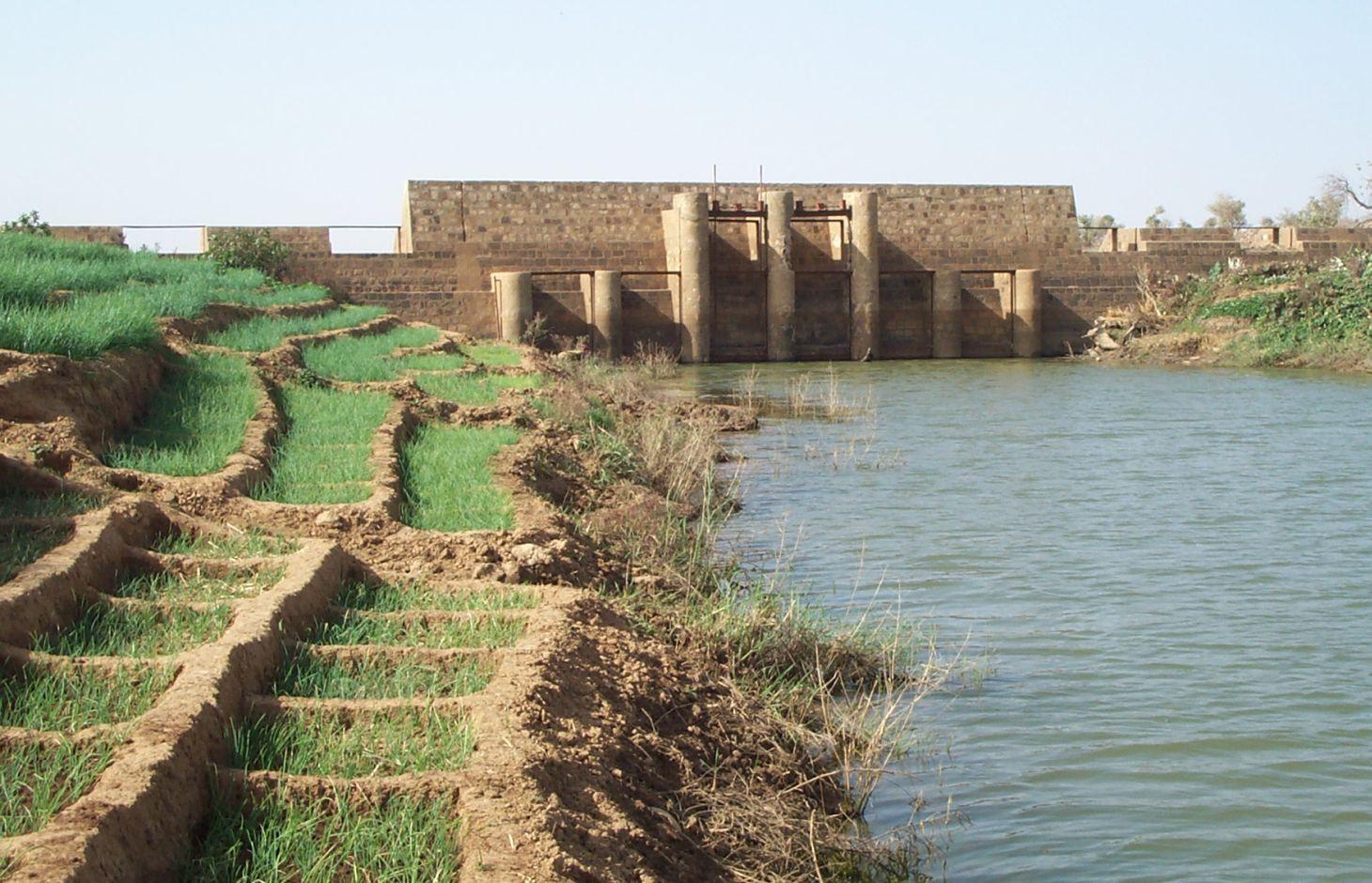
Small-scale dams are moderately-sized barriers built across valley bottoms to retain water from permanent watercourses or seasonal flows.
2.2 Descrição detalhada da tecnologia
Descrição:
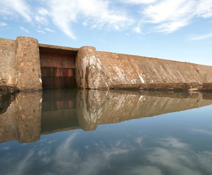
They can range in length from 100 to 200 m, and the dam wall is usually between 2 and 4 m high. Small-scale dams impound permanent or seasonal water behind them, covering areas from 5 to 15 hectares. They are built with buttresses and a stilling basin. Depending on local conditions, the dam wall can be made of quarry stone joined with mortar or concrete. The dikes are made of earth and can be reinforced with stones. Some such structures are built as bridge dams, providing a means of crossing the valley. The effect on the water table depends on the depth at which the dam is anchored. The deeper the foundation, the more groundwater is retained. Sometimes, they are fitted with geomembranes which extend down deeper to retain more groundwater.
In the rainy season, water gradually accumulates behind the dike, increasing the availability of surface water during the rainy season and groundwater in the dry season. The land is farmed upstream and downstream both in the rainy season and the dry season. During the rainy season, rice is grown, and the areas around the body of water are used for other crops (flood-recession cropping). Dams increase the area of farmable land, yields and production. The water is also used for livestock, for fish farming and sometimes for household needs. The recharged water table feeds market garden wells, enabling farmers to grow vegetables in the dry season and permitting two or three crop harvests a year which increases the availability of food, providing income for farmers and guaranteeing work all year round. This improves the stability of local communities, increases their income and raises their standard of living.
Sustainable operation and management depend directly on the participatory approach. At the planning stage, the condition of the valley upstream and downstream and all user groups must be taken into account. The question of land tenure, in particular, must be settled before construction begins. It must be determined who the owner of the bottomlands is, who will be entitled to use them once the dam has been constructed, what uses will be permitted and under what conditions. The question of project ownership and upkeep must also be clarified. Today, the role of project owner is normally assigned to the commune authorities, although management of the dam is often delegated to a management committee. In order to avoid conflicts, it is essential to take into account all the user groups, livestock keepers in particular. Watering corridors must be established to prevent animals from damaging the crops. In order to maximise the value of the investment, well-organised management committees must be set up to ensure efficient crop production and oversee maintenance work. A management committee controls the opening and closing of the gates. It organises the maintenance of the structure and the implementation of any additional measures necessary to protect the gabion structures and stone bunds. It also collects and manages funds for the maintenance of the dam and organises meetings of farmers. In dry periods, it is important to manage water resources in such a way that downstream areas have enough water. When a series of dams are built on the same watercourse, an inter-dam committee may be required to manage the distribution of water and avoid conflicts between the users of the different dams.
Well-constructed small-scale dams last at least 50 years with a certain amount of upkeep. A high standard of technical planning and construction is required for small-scale dams to avoid subsequent damage. Depending on the natural characteristics of the watershed, small-scale dams may require additional SWC/SPR measures upstream to protect them from siltation.
These small-scale dams are suitable for use in narrower valleys, as a considerable volume of water can be impounded with a relatively short structure. They are not as well suited to wide, gently sloping valleys, as very long dikes are required and this increases the cost.
2.3 Fotos da tecnologia
Galeria de Mídias
2.5 País/região/locais onde a tecnologia foi aplicada e que estão cobertos nesta avaliação
País:
Mali
Região/Estado/Província:
Mali
Especifique a difusão da tecnologia:
- Uniformemente difundida numa área
Se a área precisa não for conhecida, indicar a área aproximada coberta:
- 0,1-1 km2
Comentários:
Small-scale dams impound permanent or seasonal water behind them, covering areas from 5 to 15 hectares
2.6 Data da implementação
Caso o ano exato seja desconhecido, indique a data aproximada:
- 10-50 anos atrás
2.7 Introdução da tecnologia
Especifique como a tecnologia foi introduzida:
- através de projetos/intervenções externas
Comentários (tipos de projeto, etc.):
developed, implemented and disseminated as part of projects and programmes undertaken from the 1980s onwards to combat desertification and improve natural resource management. Implemented by GIZ (German Federal Enterprise for International Cooperation), and the project to rehabilitate dams and tracks (PRBP) and the Mali north programme (PMN)
3. Classificação da tecnologia de GST
3.1 Principal/principais finalidade(s) da tecnologia
- Melhora a produção
3.2 Tipo(s) atualizado(s) de uso da terra onde a tecnologia foi aplicada

Terra de cultivo
- Cultura anual
Número de estações de cultivo por ano:
- 1
Especifique:
Longest growing period in days: 120, Longest growing period from month to month: August to October

Vias navegáveis, corpo d'água, zonas úmidas
- Lagos, represas
Comentários:
Major land use problems (compiler’s opinion): lack of irrigation water, surface water, soil erosion by water and wind
Constraints of common grazing land
Constraints of forested government-owned land or commons
3.4 Abastecimento de água
Abastecimento de água para a terra na qual a tecnologia é aplicada:
- Misto de precipitação natural-irrigado
3.5 Grupo de GST ao qual pertence a tecnologia
- Gestão de irrigação (inclusive abastecimento de água, drenagem)
- Desvio e drenagem de água
- Gestão de água de superfície (nascente, rio, lagos, mar)
3.6 Medidas de GST contendo a tecnologia

Medidas estruturais
- S5: Represa, bacia, lago
3.7 Principais tipos de degradação da terra abordados pela tecnologia

Deteriorização química do solo
- Cn: declínio de fertilidade e teor reduzido de matéria orgânica (não causado pela erosão)

Degradação biológica
- Bc: redução da cobertura vegetal

Degradação da água
- Ha: aridificação
- Hg: mudança no lençol freático/aquífero
Comentários:
Main causes of degradation: crop management (annual, perennial, tree/shrub), floods, droughts, population pressure, land tenure
3.8 Redução, prevenção ou recuperação da degradação do solo
Especifique o objetivo da tecnologia em relação a degradação da terra:
- Prevenir degradação do solo
- Recuperar/reabilitar solo severamente degradado
4. Especificações técnicas, implementação de atividades, entradas e custos
4.1 Desenho técnico da tecnologia
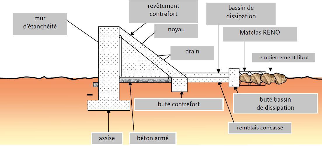
Especificações técnicas (relacionada ao desenho técnico):
They can range in length from 100 to 200 m, and the dam wall is usually between 2 and 4 m high.
Technical knowledge required for field staff / advisors: high
Technical knowledge required for land users: low
Main technical functions: control of dispersed runoff: retain / trap, control of concentrated runoff: retain / trap, increase of infiltration, increase / maintain water stored in soil, increase of groundwater level / recharge of groundwater, water harvesting / increase water supply
Secondary technical functions: increase in organic matter, increase in nutrient availability (supply, recycling,…), sediment retention / trapping, sediment harvesting, increase of biomass (quantity), promotion of vegetation species and varieties (quality, eg palatable fodder)
Dam/ pan/ pond
Depth of ditches/pits/dams (m): 2-4
Length of ditches/pits/dams (m): 100-200
Autor:
PIPRO-DB
4.3 Atividades de implantação
| Atividade | Periodicidade (estação do ano) | |
|---|---|---|
| 1. | At the planning stage, the condition of the valley upstream and downstream and all user groups must be taken into account. The question of land tenure must be settled before construction begins. The question of project ownership and upkeep must also be clarified. | |
| 2. | In order to avoid conflicts, it is essential to take into account all the user groups, livestock keepers in particular | |
| 3. | Construction of dam | |
| 4. | Watering corridors must be established to prevent animals from damaging the crops | |
| 5. | well-organised management committees must be set up to ensure efficient crop production and oversee maintenance work |
4.5 Atividades recorrentes/manutenção
| Atividade | Periodicidade/frequência | |
|---|---|---|
| 1. | A management committee controls the opening and closing of the gates. It organises the maintenance of the structure and the implementation of any additional measures necessary to protect the gabion structures and stone bunds. It also collects and manages funds for the maintenance of the dam and organises meetings of farmers | |
| 2. | Depending on the natural characteristics of the watershed, small-scale dams may require additional SWC/SPR measures upstream to protect them from siltation. |
4.7 Fatores mais importantes que afetam os custos
Descreva os fatores mais determinantes que afetam os custos:
The cost of small-scale dams varies greatly depending on the physical characteristics of the site, the size of the structure and the local availability of materials. In Dogon country, in Mali, the PDRT project constructed dams with cyclopean concrete costing an average of around 20 million CFA francs and between 3 and 5 million CFA francs per hectare. The internal rate of return of the dams built averaged 17% (Nill & Kobilke, 2002). Larger dams built in the Beledougou area cost 100-140 million CFA francs. Helvetas Swiss Intercooperation reports costs of around 20 million CFA francs for areas of 10-80 hectares (PASSIP, 2012).
5. Ambiente natural e humano
5.1 Clima
Precipitação pluviométrica anual
- <250 mm
- 251-500 mm
- 501-750 mm
- 751-1.000 mm
- 1.001-1.500 mm
- 1.501-2.000 mm
- 2.001-3.000 mm
- 3.001-4.000 mm
- > 4.000 mm
Zona agroclimática
- Semiárido
Thermal climate class: subtropics
5.2 Topografia
Declividade média:
- Plano (0-2%)
- Suave ondulado (3-5%)
- Ondulado (6-10%)
- Moderadamente ondulado (11-15%)
- Forte ondulado (16-30%)
- Montanhoso (31-60%)
- Escarpado (>60%)
Formas de relevo:
- Planalto/planície
- Cumes
- Encosta de serra
- Encosta de morro
- Sopés
- Fundos de vale
Zona de altitude:
- 0-100 m s.n.m.
- 101-500 m s.n.m.
- 501-1.000 m s.n.m.
- 1.001-1.500 m s.n.m.
- 1.501-2.000 m s.n.m.
- 2.001-2.500 m s.n.m.
- 2.501-3.000 m s.n.m.
- 3.001-4.000 m s.n.m.
- > 4.000 m s.n.m.
5.3 Solos
Profundidade do solo em média:
- Muito raso (0-20 cm)
- Raso (21-50 cm)
- Moderadamente profundo (51-80 cm)
- Profundo (81-120 cm)
- Muito profundo (>120 cm)
Textura do solo (solo superficial):
- Médio (limoso, siltoso)
- Fino/pesado (argila)
5.4 Disponibilidade e qualidade de água
Lençol freático:
5-50 m
Disponibilidade de água de superfície:
Médio
5.5 Biodiversidade
Diversidade de espécies:
- Baixo
5.6 Características dos usuários da terra que utilizam a tecnologia
Nível relativo de riqueza:
- Muito pobre
- Pobre
Nível de mecanização:
- Trabalho manual
- Tração animal
Gênero:
- Homens
Indique outras características relevantes dos usuários da terra:
Population density: 10-50 persons/km2
Annual population growth: 3% - 4% (mostly poor households below poverty line).
Off-farm income specification: men migrate temporarily or permanently to cities for off-farm income
5.7 Área média de terrenos utilizados pelos usuários de terrenos que aplicam a Tecnologia
- < 0,5 ha
- 0,5-1 ha
- 1-2 ha
- 2-5 ha
- 5-15 ha
- 15-50 ha
- 50-100 ha
- 100-500 ha
- 500-1.000 ha
- 1.000-10.000 ha
- > 10.000 ha
É considerado pequena, média ou grande escala (referente ao contexto local)?
- Pequena escala
5.8 Propriedade de terra, direitos de uso da terra e de uso da água
Propriedade da terra:
- Estado
Direitos do uso da terra:
- Comunitário (organizado)
Direitos do uso da água:
- Comunitário (organizado)
Comentários:
traditional land use rights on fields, communal land on pasture and forest land
5.9 Acesso a serviços e infraestrutura
Saúde:
- Pobre
- Moderado
- Bom
Educação:
- Pobre
- Moderado
- Bom
Assistência técnica:
- Pobre
- Moderado
- Bom
Emprego (p. ex. não agrícola):
- Pobre
- Moderado
- Bom
Mercados:
- Pobre
- Moderado
- Bom
Energia:
- Pobre
- Moderado
- Bom
Vias e transporte:
- Pobre
- Moderado
- Bom
Água potável e saneamento:
- Pobre
- Moderado
- Bom
Serviços financeiros:
- Pobre
- Moderado
- Bom
6. Impactos e declarações finais
6.1 Impactos no local mostrados pela tecnologia
Impactos socioeconômicos
Produção
Produção agrícola
Produção de forragens
Risco de falha de produção
Área de produção
Disponibilidade e qualidade de água
Demanda por água para irrigação
Impactos socioculturais
Segurança alimentar/auto-suficiência
contribution to human well-being
Comentários/especificar:
The water impounded by small-scale dams makes it possible to farm a much larger area in the valley bottoms and ensures better yields in the rainy season and also in the off-season. The production of food staples and market garden output increases significantly. More intense production ensures employment all year round, which improves the stability of local communities, increases their income and raises their standard of living.
Impactos ecológicos
Ciclo hídrico/escoamento
Quantidade de água
Colheita/recolhimento de água
Lençol freático/aquífero
Solo
Umidade do solo
Cobertura do solo
Perda de solo
Ciclo e recarga de nutrientes
Biodiversidade: vegetação, animais
Espécies benéficas
6.2 Impactos externos mostrados pela tecnologia
Caudal confiável e estável em período seco
Cheias de jusante
Sedimentação a jusante
6.3 Exposição e sensibilidade da tecnologia às mudanças climáticas graduais e extremos/desastres relacionados ao clima (conforme o ponto de vista dos usuários da terra)
Mudança climática gradual
Mudança climática gradual
| Estação do ano | aumento ou diminuição | Como a tecnologia lida com isso? | |
|---|---|---|---|
| Temperatura anual | aumento | bem |
Extremos (desastres) relacionados ao clima
Desastres meteorológicos
| Como a tecnologia lida com isso? | |
|---|---|
| Temporal local | bem |
| Tempestade de vento local | bem |
Desastres climatológicos
| Como a tecnologia lida com isso? | |
|---|---|
| Seca | bem |
Desastres hidrológicos
| Como a tecnologia lida com isso? | |
|---|---|
| Inundação geral (rio) | bem |
Outras consequências relacionadas ao clima
Outras consequências relacionadas ao clima
| Como a tecnologia lida com isso? | |
|---|---|
| Período de crescimento reduzido | bem |
6.4 Análise do custo-benefício
Como os benefícios se comparam aos custos de implantação (do ponto de vista dos usuários da terra)?
Retornos a curto prazo:
positivo
Retornos a longo prazo:
muito positivo
Como os benefícios se comparam aos custos recorrentes/de manutenção(do ponto de vista dos usuários da terra)?
Retornos a curto prazo:
muito positivo
Retornos a longo prazo:
muito positivo
6.7 Pontos fortes/vantagens/oportunidades da tecnologia
| Pontos fortes/vantagens/oportunidades na visão do compilador ou de outra pessoa capacitada |
|---|
| The small-scale dams create water reserves. When there is not enough rain or during dry spells in the rainy season, the dams retain enough water for crops throughout their growth cycle. If rain-fed crops fail, production in the valley bottoms can mitigate these losses. In wet years, the dams regulate the flow of water, preventing heavy floodwaters from causing damage to land downstream. |
| The water impounded by small-scale dams makes it possible to farm a much larger area in the valley bottoms and ensures better yields in the rainy season and also in the off-season. The production of food staples and market garden output increases significantly. More intense production ensures employment all year round, which improves the stability of local communities, increases their income and raises their standard of living. |
| In the dry season, the recharged water table makes a second and even third crop harvest possible, increasing the availability of food, providing income for farmers and guaranteeing work all year round. |
| Replenished water tables not only improve crop output, they also reduce the time and effort that women devote to fetching water and make it easier to water livestock. |
6.8 Pontos fracos, desvantagens/riscos da tecnologia e formas de superá-los
| Pontos fracos/vantagens/riscos na visão do compilador ou de outra pessoa capacitada | Como eles podem ser superados? |
|---|---|
| A high standard of technical planning and construction is required for small-scale dams to avoid subsequent damage. | In order to maximise the value of the investment, well-organised management committees must be set up to ensure efficient crop production and oversee maintenance work. |
7. Referências e links
7.1 Métodos/fontes de informação
- visitas de campo, pesquisas de campo
- entrevistas com usuários de terras
Quando os dados foram compilados (no campo)?
01/07/2012
7.2 Referências às publicações disponíveis
Título, autor, ano, ISBN:
Good Practices in Soil and Water Conservation. A contribution to adaptation and farmers´ resilience towards climate change in the Sahel. Published by GIZ in 2012.
Disponível de onde? Custos?
http://agriwaterpedia.info/wiki/Main_Page
Links e módulos
Expandir tudo Recolher tudoLinks
Não há links
Módulos
Não há módulos