Contour Trench Bund [Afeganistão]
- Criação:
- Atualização:
- Compilador/a: Aqila Haidery
- Editor: –
- Revisores: David Streiff, Joana Eichenberger
Chuquorak Band Khaki (Dari)
technologies_1724 - Afeganistão
Veja as seções
Expandir tudo Recolher tudo1. Informação geral
1.2 Detalhes do contato das pessoas capacitadas e instituições envolvidas na avaliação e documentação da tecnologia
Especialista em GST:
Especialista em GST:
Especialista em GST:
Ershad Mustafa
Catholic Relief Services
Nome da(s) instituição(ões) que facilitou(ram) a documentação/ avaliação da Tecnologia (se relevante)
HELVETAS (Swiss Intercooperation)Nome da(s) instituição(ões) que facilitou(ram) a documentação/ avaliação da Tecnologia (se relevante)
Catholic Relief Services/East Africa (Catholic Relief Services/East Africa) - Quênia1.3 Condições em relação ao uso da informação documentada através de WOCAT
O/a compilador/a e a(s) pessoa(s) capacitada(s) aceitam as condições relativas ao uso de dados documentados através da WOCAT:
Sim
1.5 Referência ao(s) questionário(s) sobre abordagens GST (documentado(s) usando WOCAT)
Community-Based Watershed Management [Afeganistão]
Sustainable implementation of watershed management through appropriate SLM technologies, formation of organizational structures and capacity building of stakeholders
- Compilador/a: Aqila Haidery
2. Descrição da tecnologia de GST
2.1 Descrição curta da tecnologia
Definição da tecnologia:
Contour trench bund applied on contour lines of moderate slope to trap run-off to improve infiltration and reduce flash floods.
2.2 Descrição detalhada da tecnologia
Descrição:
The Contour Trench Bund technology is documented by Sustainable Land Management
Project/HELVETAS Swiss Intercooperation with financial support of Swiss Agency for
Development and Cooperation(SDC) and close support and cooperation of the Catholic
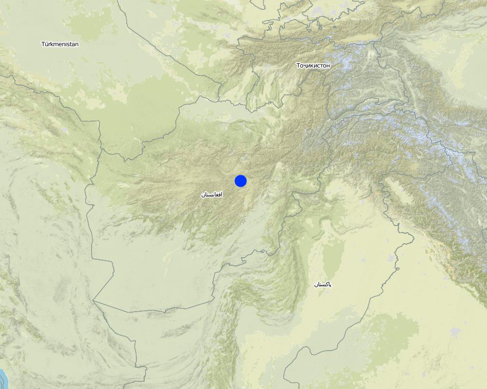
Relief Service (CRS). The technology was applied in Sar-e Ahengaran watershed of Bamyan centre, an area of 0.08 km2 as part of a watershed project by the Catholic Relief Services (CRS). The total watershed area is 67 ha. The project started in October 2009 involving the community with funding support from USAID and CRS. The project came to an end in March 2013.
Purpose of the Technology: The main purpose of the contour trench bund technology is to reduce excessive surface runoff and improve infiltration. It also contributes to increased vegetation cover.
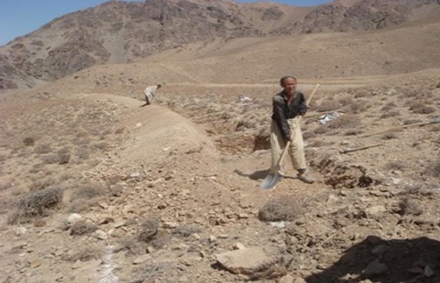
Establishment / maintenance activities and inputs: The main activities for this SLM technology include: site selection and technical planning in October 2009; demarcation of contour lines using A-frame and lime; and digging trenches and construction of soil bunds. The technology was established over 10 months. The project used a “Cash for Work” approach; local people were employed for construction works. Cost-wise, approximately 7,536 USD were spent on this technology (approximately 942 USD/ha) with 90% contribution from the project and 10% from the participating community. There have been no maintenance costs so far for this technology.
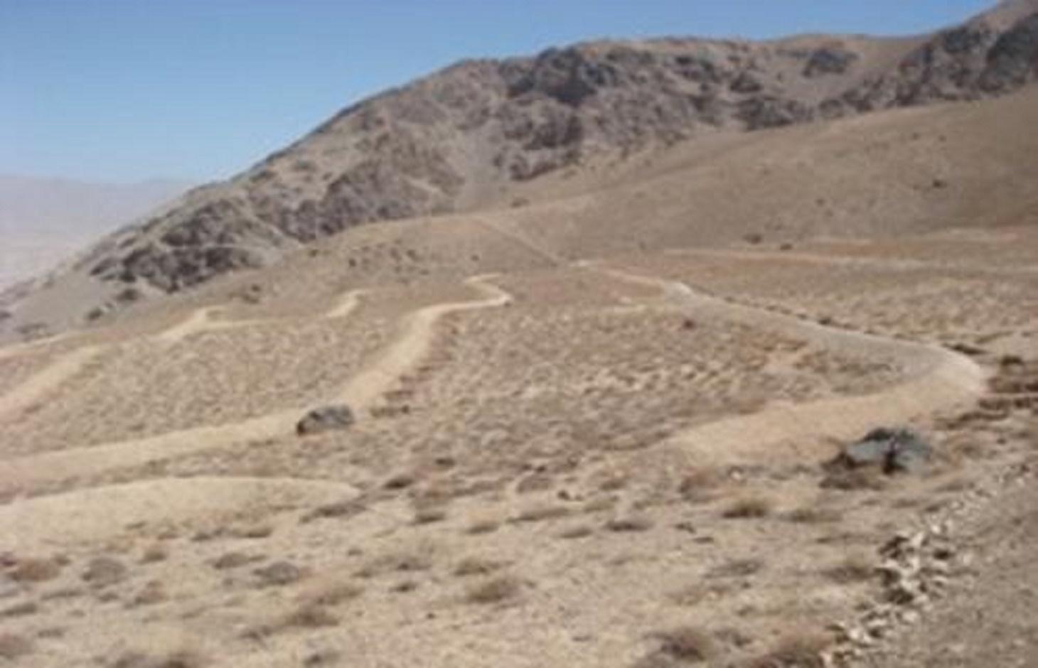
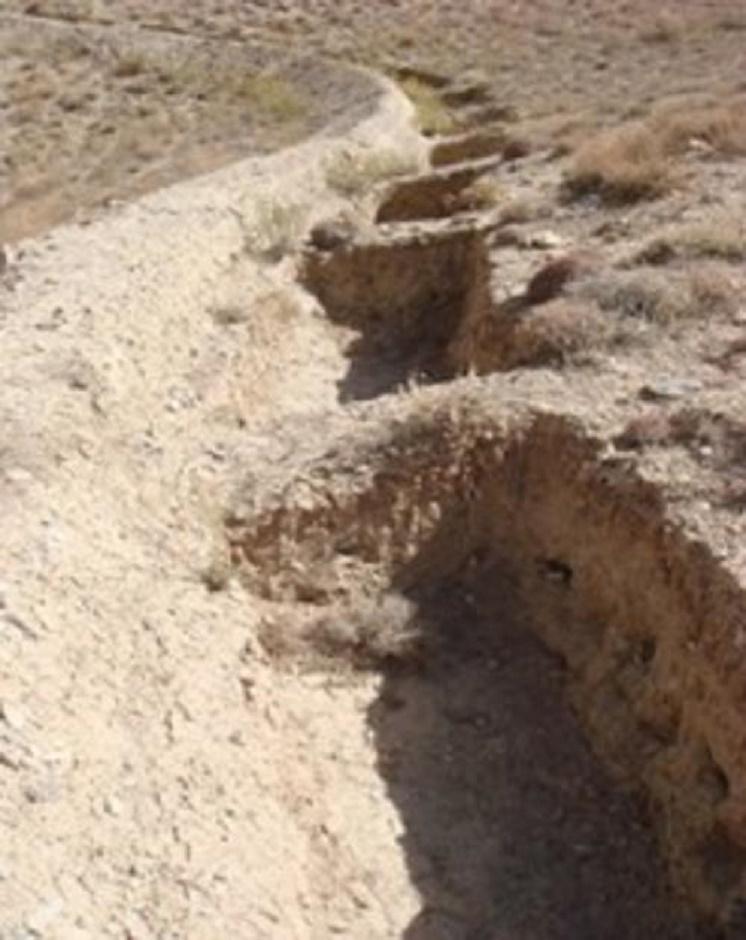
Dimensions of a trenches are: 0.7 m in depth, 1.2 m width, 3 m length and of the bunds: 0.45 m in height, 1.2 m in width, 100 m in length with 12 m spacing and 1.5 m vertical interval between two contour lines. Contour trenches were applied on hilly (16-30%) slopes at an altitude of 2500-3000 m. The technology is tolerant to temperature, seasonal rainfall, storms and droughts and sensitive to heavy rainfall events and floods. The soil in the watershed is sandy to loamy type, and infertile with a depth of 20-50 cm. The infiltration is medium.
The technology is part of the watershed management system. Other measures implemented included stone walls, cultivation of fodder grasses and ban on grazing and shrub cutting at the site. The land ownership (in the watershed) is communal with open access water rights. Medium scale land users, mainly men, applied the technology. Women and school children participated in meetings concerning awareness raising. There is also a watershed and pasture management committee for site management.
Natural / human environment: The annual rainfall in the area is 250-500 mm. The agro-climate is semi-arid and temperate type with the longest growing period of 180 days from April to October. The people in this area are mainly poor. 10-50 % of all income comes from off-farm activities. Access to health, market and financial services is low and education, roads, transport, drinking water and sanitation facilities are moderate. Agriculture is of mixed type, subsistence and commercial based.
2.3 Fotos da tecnologia
Galeria de Mídias
2.5 País/região/locais onde a tecnologia foi aplicada e que estão cobertos nesta avaliação
País:
Afeganistão
Região/Estado/Província:
Sar_e_Ahangaran, Bamyan center
Map
×2.6 Data da implementação
Caso o ano exato seja desconhecido, indique a data aproximada:
- menos de 10 anos atrás (recentemente)
2.7 Introdução da tecnologia
Especifique como a tecnologia foi introduzida:
- através de projetos/intervenções externas
3. Classificação da tecnologia de GST
3.1 Principal/principais finalidade(s) da tecnologia
- Protege uma bacia/zonas a jusante – em combinação com outra tecnologia
- Reduzir riscos de desastre
3.2 Tipo(s) atualizado(s) de uso da terra onde a tecnologia foi aplicada

Pastagem
Pastagem extensiva:
- Pastoralismo semi-nômade
Tipo de animal:
- gado - lácteo
- caprinos
- ovelhas
Comentários:
Major land use problems (compiler’s opinion): Reduction of the vegetation cover causes flash floods and accelerated erosion. The water level goes down and there is no moisture in the soil.
Major land use problems (land users’ perception): Downstream flash flood and shortage of spring water due to overgrazing of the range-land.
Future (final) land use (after implementation of SLM Technology): Grazing land: Gi: Intensive grazing/ fodder production
3.4 Abastecimento de água
Abastecimento de água para a terra na qual a tecnologia é aplicada:
- Misto de precipitação natural-irrigado
3.5 Grupo de GST ao qual pertence a tecnologia
- Solo/cobertura vegetal melhorada
- Medidas de curva de nível
3.6 Medidas de GST contendo a tecnologia

Medidas estruturais
- S2: Barragens, bancos
- S4: Valas de nível, fossos
Comentários:
Main measures: structural measures
3.7 Principais tipos de degradação da terra abordados pela tecnologia

Erosão do solo pela água
- Wt: Perda do solo superficial/erosão de superfície
Comentários:
Main causes of degradation: over-exploitation of vegetation for domestic use, overgrazing
3.8 Redução, prevenção ou recuperação da degradação do solo
Especifique o objetivo da tecnologia em relação a degradação da terra:
- Reduzir a degradação do solo
4. Especificações técnicas, implementação de atividades, entradas e custos
4.1 Desenho técnico da tecnologia
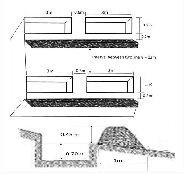
Autor:
Mustafa Ershad
4.2 Informação geral em relação ao cálculo de entradas e custos
Especifique a moeda utilizada para os cálculos de custo:
- USD
4.3 Atividades de implantação
| Atividade | Periodicidade (estação do ano) | |
|---|---|---|
| 1. | Demarcation of the contour lines using A frame and Lime | |
| 2. | Excavation of the trenches and construction of the soil bunds |
4.4 Custos e entradas necessárias para a implantação
| Especifique a entrada | Unidade | Quantidade | Custos por unidade | Custos totais por entrada | % dos custos arcados pelos usuários da terra | |
|---|---|---|---|---|---|---|
| Mão-de-obra | Demarcation of the contour lines | ha | 1,0 | 92,0 | 92,0 | |
| Mão-de-obra | Excavation of the trenches and construction of the soil bunds | persons/day/ha | 121,0 | 7,0 | 847,0 | 10,0 |
| Custos totais para a implantação da tecnologia | 939,0 | |||||
| Custos totais para o estabelecimento da Tecnologia em USD | 939,0 | |||||
Comentários:
Duration of establishment phase: 10 month(s)
4.5 Atividades recorrentes/manutenção
| Atividade | Periodicidade/frequência | |
|---|---|---|
| 1. | No maintenance costs so far for CRS. |
4.7 Fatores mais importantes que afetam os custos
Descreva os fatores mais determinantes que afetam os custos:
The establishment duration of the Contour Trench Bund was 10 months.
5. Ambiente natural e humano
5.1 Clima
Precipitação pluviométrica anual
- <250 mm
- 251-500 mm
- 501-750 mm
- 751-1.000 mm
- 1.001-1.500 mm
- 1.501-2.000 mm
- 2.001-3.000 mm
- 3.001-4.000 mm
- > 4.000 mm
Zona agroclimática
- Semiárido
Thermal climate class: Temperate
5.2 Topografia
Declividade média:
- Plano (0-2%)
- Suave ondulado (3-5%)
- Ondulado (6-10%)
- Moderadamente ondulado (11-15%)
- Forte ondulado (16-30%)
- Montanhoso (31-60%)
- Escarpado (>60%)
Formas de relevo:
- Planalto/planície
- Cumes
- Encosta de serra
- Encosta de morro
- Sopés
- Fundos de vale
Zona de altitude:
- 0-100 m s.n.m.
- 101-500 m s.n.m.
- 501-1.000 m s.n.m.
- 1.001-1.500 m s.n.m.
- 1.501-2.000 m s.n.m.
- 2.001-2.500 m s.n.m.
- 2.501-3.000 m s.n.m.
- 3.001-4.000 m s.n.m.
- > 4.000 m s.n.m.
5.3 Solos
Profundidade do solo em média:
- Muito raso (0-20 cm)
- Raso (21-50 cm)
- Moderadamente profundo (51-80 cm)
- Profundo (81-120 cm)
- Muito profundo (>120 cm)
Textura do solo (solo superficial):
- Grosso/fino (arenoso)
- Médio (limoso, siltoso)
Matéria orgânica do solo superficial:
- Baixo (<1%)
Caso disponível anexe a descrição completa do solo ou especifique as informações disponíveis, p. ex. tipo de solo, PH/acidez do solo, nitrogênio, capacidade de troca catiônica, salinidade, etc.
Soil fertility is low - medium
Soil drainage / infiltration is medium
Soil water storage capacity is medium
5.4 Disponibilidade e qualidade de água
Lençol freático:
5-50 m
Disponibilidade de água de superfície:
Precário/nenhum
Qualidade da água (não tratada):
Água potável boa
5.5 Biodiversidade
Diversidade de espécies:
- Médio
5.6 Características dos usuários da terra que utilizam a tecnologia
Orientação de mercado do sistema de produção:
- misto (subsistência/comercial)
Rendimento não agrícola:
- 10-50% de toda renda
Nível relativo de riqueza:
- Pobre
Indivíduos ou grupos:
- Grupos/comunidade
Gênero:
- Homens
Indique outras características relevantes dos usuários da terra:
Difference in the involvement of women and men: Workload does not give chance to women to work on the mountains.
Population density: < 10 persons/km2
Annual population growth: 2% - 3%
50% of the land users are poor.
Off-farm income specification: Busy with carpentry and migrate for work.
5.7 Área média de terrenos utilizados pelos usuários de terrenos que aplicam a Tecnologia
- < 0,5 ha
- 0,5-1 ha
- 1-2 ha
- 2-5 ha
- 5-15 ha
- 15-50 ha
- 50-100 ha
- 100-500 ha
- 500-1.000 ha
- 1.000-10.000 ha
- > 10.000 ha
É considerado pequena, média ou grande escala (referente ao contexto local)?
- Média escala
5.8 Propriedade de terra, direitos de uso da terra e de uso da água
Propriedade da terra:
- Comunitário/rural
Direitos do uso da terra:
- Comunitário (organizado)
Direitos do uso da água:
- Acesso livre (não organizado)
5.9 Acesso a serviços e infraestrutura
Saúde:
- Pobre
- Moderado
- Bom
Educação:
- Pobre
- Moderado
- Bom
Assistência técnica:
- Pobre
- Moderado
- Bom
Emprego (p. ex. não agrícola):
- Pobre
- Moderado
- Bom
Mercados:
- Pobre
- Moderado
- Bom
Energia:
- Pobre
- Moderado
- Bom
Vias e transporte:
- Pobre
- Moderado
- Bom
Água potável e saneamento:
- Pobre
- Moderado
- Bom
Serviços financeiros:
- Pobre
- Moderado
- Bom
6. Impactos e declarações finais
6.1 Impactos no local mostrados pela tecnologia
Impactos socioeconômicos
Produção
Produção de forragens
Comentários/especificar:
Due to better soil moisture
Renda e custos
Diversidade de fontes de rendimento
Impactos socioculturais
Conhecimento de GST/ degradação da terra
Situação de grupos social e economicamente desfavorecidos
livelihood and human well-being
Comentários/especificar:
Due to reduction in flash floods problem and increased access to drinking water, Seasonal job opportunities created through cash for work
Impactos ecológicos
Ciclo hídrico/escoamento
Colheita/recolhimento de água
Comentários/especificar:
of surface run off
Lençol freático/aquífero
Solo
Umidade do solo
Perda de solo
Biodiversidade: vegetação, animais
Biomassa/carbono acima do solo
Comentários/especificar:
Due to more moisture
Clima e redução de riscos de desastre
Impactos da inundação
Outros impactos ecológicos
disturbance of soil and vegetation during excavation works
6.2 Impactos externos mostrados pela tecnologia
Disponibilidade de água
Cheias de jusante
Sedimentação a jusante
Comentários/especificar:
And sedimentation
damage on agriculture fields
As the site is closed, grazing pressure shifts elsewhere
6.3 Exposição e sensibilidade da tecnologia às mudanças climáticas graduais e extremos/desastres relacionados ao clima (conforme o ponto de vista dos usuários da terra)
Mudança climática gradual
Mudança climática gradual
| Estação do ano | aumento ou diminuição | Como a tecnologia lida com isso? | |
|---|---|---|---|
| Temperatura anual | aumento | bem |
Extremos (desastres) relacionados ao clima
Desastres meteorológicos
| Como a tecnologia lida com isso? | |
|---|---|
| Tempestade de vento local | bem |
Desastres climatológicos
| Como a tecnologia lida com isso? | |
|---|---|
| Seca | bem |
Outras consequências relacionadas ao clima
Outras consequências relacionadas ao clima
| Como a tecnologia lida com isso? | |
|---|---|
| Extreme precipitation events especially if the technology is applied on steep slopes. | não bem |
Comentários:
Increase size, stable bunds stabilized with vegetation
6.4 Análise do custo-benefício
Como os benefícios se comparam aos custos de implantação (do ponto de vista dos usuários da terra)?
Retornos a curto prazo:
levemente negativo
Retornos a longo prazo:
positivo
Como os benefícios se comparam aos custos recorrentes/de manutenção(do ponto de vista dos usuários da terra)?
Retornos a curto prazo:
neutro/balanceado
Retornos a longo prazo:
muito positivo
Comentários:
The benefits will be more in the long term when trees, shrubs and fodder grasses are ready to harvest.
6.5 Adoção da tecnologia
Comentários:
Comments on acceptance with external material support: Appropriate information is not available.
Comments on spontaneous adoption: Only soil bunds have been applied by a few farmers on their private lands.
6.7 Pontos fortes/vantagens/oportunidades da tecnologia
| Pontos fortes/vantagens/oportunidades na visão do usuário da terra |
|---|
|
The technology helps to create SLM based job opportunities for many people. How can they be sustained / enhanced? Needs external support/projects. |
| Pontos fortes/vantagens/oportunidades na visão do/a compilador/a ou de outra pessoa capacitada |
|---|
|
Demonstration of link between SLM measures and water source. How can they be sustained / enhanced? Conducting training and showing drawing. |
|
Technical knowledge of community enhanced. How can they be sustained / enhanced? Share more aspects of the technology, where to apply and how. |
|
Flood reduction, greening of the area, increase the spring water. How can they be sustained / enhanced? Cultivate native plants, share experiences with more communities and SLM specialists. |
|
Good for land rehabilitation (extremely degraded lands). How can they be sustained / enhanced? Always combine with vegetative and management measures. |
6.8 Pontos fracos, desvantagens/riscos da tecnologia e formas de superá-los
| Pontos fracos/desvantagens/riscos na visão do usuário da terra | Como eles podem ser superados? |
|---|---|
| Farmers do not prefer to construct this technology because it requires soil excavation/disturbance. | One needs to show how such measures have been applied in other parts of the world for multiple benefits through action research. |
| Pontos fracos/vantagens/riscos na visão do/a compilador/a ou de outra pessoa capacitada | Como eles podem ser superados? |
|---|---|
| Site selection | Apply technology at suitable site that has proper slope and is really degraded. Avoid places where there is already good vegetation cover. |
| Higher cost of establishment of the technology. | Encourage the community for more contribution or apply where absolutely necessary. |
| Technical design | The designer should research more about the site and discuss with the skilled people of the community before designing. |
| Few vegetative measures | plant fodder grasses and adapted trees between trenches. |
7. Referências e links
7.1 Métodos/fontes de informação
Links e módulos
Expandir tudo Recolher tudoLinks
Community-Based Watershed Management [Afeganistão]
Sustainable implementation of watershed management through appropriate SLM technologies, formation of organizational structures and capacity building of stakeholders
- Compilador/a: Aqila Haidery
Módulos
Não há módulos