Contour Trench Bund [Afghanistan]
- Création :
- Mise à jour :
- Compilateur : Aqila Haidery
- Rédacteur : –
- Examinateurs : David Streiff, Joana Eichenberger
Chuquorak Band Khaki (Dari)
technologies_1724 - Afghanistan
Voir les sections
Développer tout Réduire tout1. Informations générales
1.2 Coordonnées des personnes-ressources et des institutions impliquées dans l'évaluation et la documentation de la Technologie
Spécialiste GDT:
Spécialiste GDT:
Spécialiste GDT:
Ershad Mustafa
Catholic Relief Services
Nom du ou des institutions qui ont facilité la documentation/ l'évaluation de la Technologie (si pertinent)
HELVETAS (Swiss Intercooperation)Nom du ou des institutions qui ont facilité la documentation/ l'évaluation de la Technologie (si pertinent)
Catholic Relief Services/East Africa (Catholic Relief Services/East Africa) - Kenya1.3 Conditions relatives à l'utilisation par WOCAT des données documentées
Le compilateur et la(les) personne(s) ressource(s) acceptent les conditions relatives à l'utilisation par WOCAT des données documentées:
Oui
1.5 Référence au(x) Questionnaires sur les Approches de GDT (documentées au moyen de WOCAT)
Community-Based Watershed Management [Afghanistan]
Sustainable implementation of watershed management through appropriate SLM technologies, formation of organizational structures and capacity building of stakeholders
- Compilateur : Aqila Haidery
2. Description de la Technologie de GDT
2.1 Courte description de la Technologie
Définition de la Technologie:
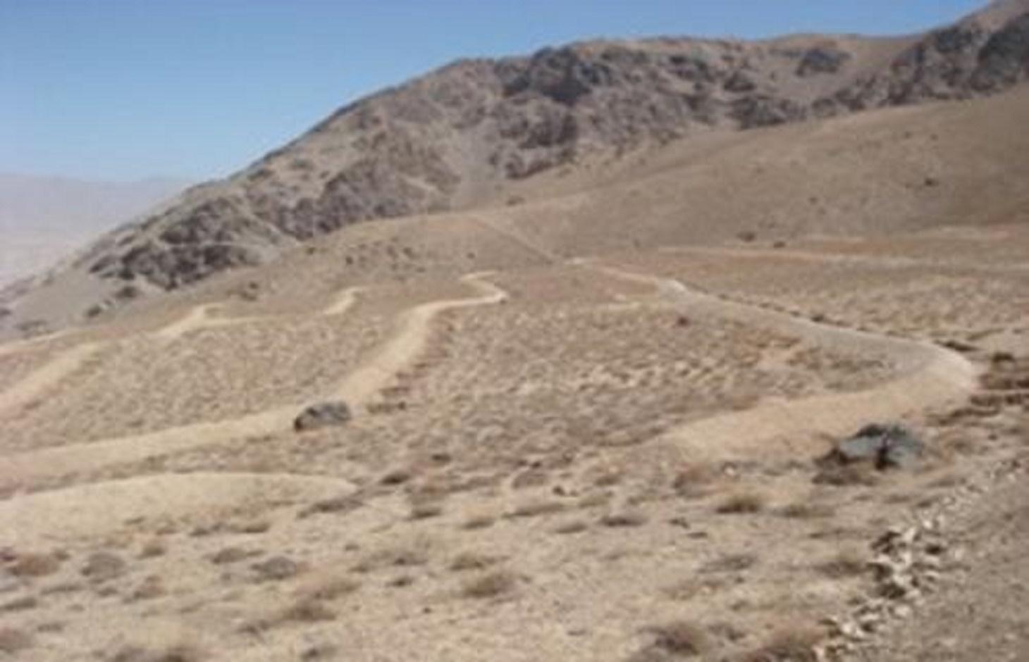
Contour trench bund applied on contour lines of moderate slope to trap run-off to improve infiltration and reduce flash floods.
2.2 Description détaillée de la Technologie
Description:
The Contour Trench Bund technology is documented by Sustainable Land Management
Project/HELVETAS Swiss Intercooperation with financial support of Swiss Agency for
Development and Cooperation(SDC) and close support and cooperation of the Catholic
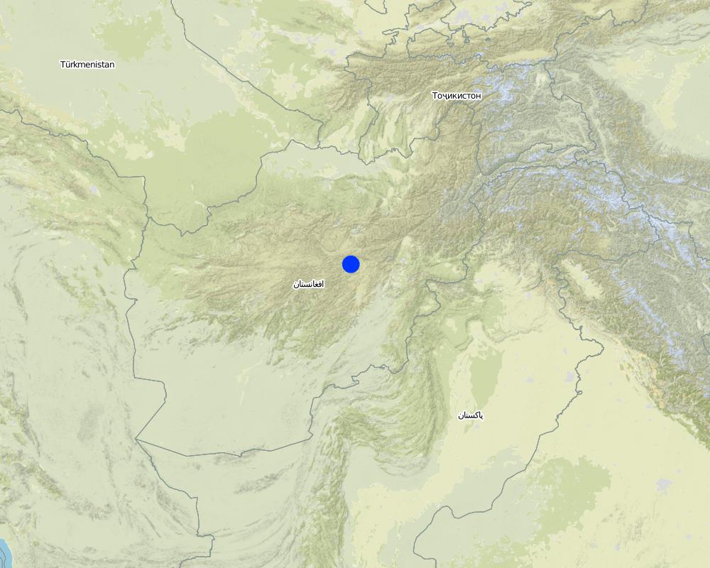
Relief Service (CRS). The technology was applied in Sar-e Ahengaran watershed of Bamyan centre, an area of 0.08 km2 as part of a watershed project by the Catholic Relief Services (CRS). The total watershed area is 67 ha. The project started in October 2009 involving the community with funding support from USAID and CRS. The project came to an end in March 2013.
Purpose of the Technology: The main purpose of the contour trench bund technology is to reduce excessive surface runoff and improve infiltration. It also contributes to increased vegetation cover.
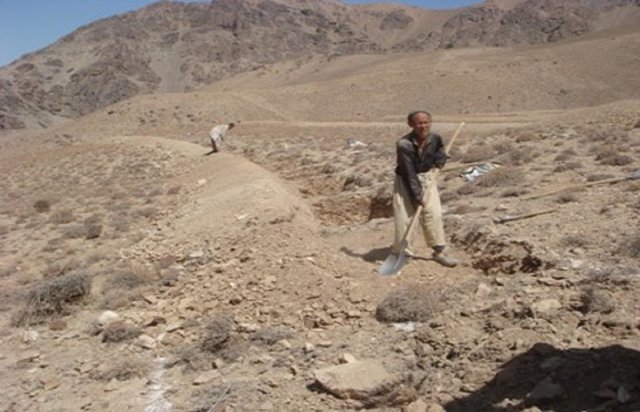
Establishment / maintenance activities and inputs: The main activities for this SLM technology include: site selection and technical planning in October 2009; demarcation of contour lines using A-frame and lime; and digging trenches and construction of soil bunds. The technology was established over 10 months. The project used a “Cash for Work” approach; local people were employed for construction works. Cost-wise, approximately 7,536 USD were spent on this technology (approximately 942 USD/ha) with 90% contribution from the project and 10% from the participating community. There have been no maintenance costs so far for this technology.
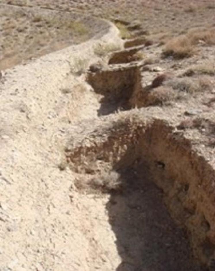
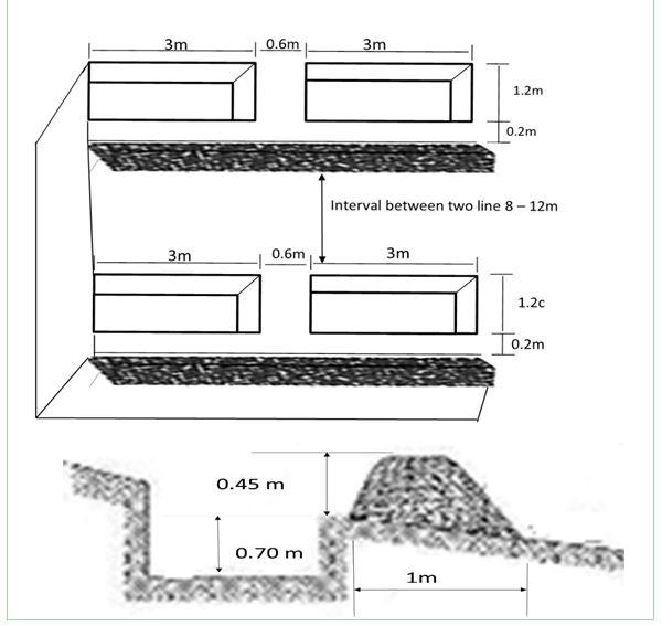
Dimensions of a trenches are: 0.7 m in depth, 1.2 m width, 3 m length and of the bunds: 0.45 m in height, 1.2 m in width, 100 m in length with 12 m spacing and 1.5 m vertical interval between two contour lines. Contour trenches were applied on hilly (16-30%) slopes at an altitude of 2500-3000 m. The technology is tolerant to temperature, seasonal rainfall, storms and droughts and sensitive to heavy rainfall events and floods. The soil in the watershed is sandy to loamy type, and infertile with a depth of 20-50 cm. The infiltration is medium.
The technology is part of the watershed management system. Other measures implemented included stone walls, cultivation of fodder grasses and ban on grazing and shrub cutting at the site. The land ownership (in the watershed) is communal with open access water rights. Medium scale land users, mainly men, applied the technology. Women and school children participated in meetings concerning awareness raising. There is also a watershed and pasture management committee for site management.
Natural / human environment: The annual rainfall in the area is 250-500 mm. The agro-climate is semi-arid and temperate type with the longest growing period of 180 days from April to October. The people in this area are mainly poor. 10-50 % of all income comes from off-farm activities. Access to health, market and financial services is low and education, roads, transport, drinking water and sanitation facilities are moderate. Agriculture is of mixed type, subsistence and commercial based.
2.3 Photos de la Technologie
Galerie Médias
2.5 Pays/ région/ lieux où la Technologie a été appliquée et qui sont couverts par cette évaluation
Pays:
Afghanistan
Région/ Etat/ Province:
Sar_e_Ahangaran, Bamyan center
Map
×2.6 Date de mise en œuvre de la Technologie
Si l'année précise est inconnue, indiquez la date approximative: :
- il y a moins de 10 ans (récemment)
2.7 Introduction de la Technologie
Spécifiez comment la Technologie a été introduite: :
- par le biais de projets/ d'interventions extérieures
3. Classification de la Technologie de GDT
3.1 Principal(aux) objectif(s) de la Technologie
- protéger un bassin versant/ des zones situées en aval - en combinaison avec d'autres technologies
- réduire les risques de catastrophes
3.2 Type(s) actuel(s) d'utilisation des terres, là où la Technologie est appliquée

Pâturages
Pâturage extensif:
- Pastoralisme de type semi-nomade
Type d'animal:
- bétail - laitier
- caprine
- ovins
Commentaires:
Major land use problems (compiler’s opinion): Reduction of the vegetation cover causes flash floods and accelerated erosion. The water level goes down and there is no moisture in the soil.
Major land use problems (land users’ perception): Downstream flash flood and shortage of spring water due to overgrazing of the range-land.
Future (final) land use (after implementation of SLM Technology): Grazing land: Gi: Intensive grazing/ fodder production
3.4 Approvisionnement en eau
Approvisionnement en eau des terres sur lesquelles est appliquée la Technologie:
- mixte: pluvial-irrigué
3.5 Groupe de GDT auquel appartient la Technologie
- Amélioration de la couverture végétale/ du sol
- mesures en travers de la pente
3.6 Mesures de GDT constituant la Technologie

structures physiques
- S2: Diguettes, digues
- S4: Fossés isohypses, trous
Commentaires:
Main measures: structural measures
3.7 Principaux types de dégradation des terres traités par la Technologie

érosion hydrique des sols
- Wt: perte de la couche superficielle des sols (couche arable)/ érosion de surface
Commentaires:
Main causes of degradation: over-exploitation of vegetation for domestic use, overgrazing
3.8 Prévention, réduction de la dégradation ou réhabilitation des terres dégradées
Spécifiez l'objectif de la Technologie au regard de la dégradation des terres:
- réduire la dégradation des terres
4. Spécifications techniques, activités, intrants et coûts de mise en œuvre
4.1 Dessin technique de la Technologie
Auteur:
Mustafa Ershad
4.2 Informations générales sur le calcul des intrants et des coûts
Indiquez la monnaie utilisée pour le calcul des coûts:
- dollars américains
4.3 Activités de mise en place/ d'établissement
| Activité | Calendrier des activités (saisonnier) | |
|---|---|---|
| 1. | Demarcation of the contour lines using A frame and Lime | |
| 2. | Excavation of the trenches and construction of the soil bunds |
4.4 Coûts et intrants nécessaires à la mise en place
| Spécifiez les intrants | Unité | Quantité | Coûts par unité | Coût total par intrant | % des coût supporté par les exploitants des terres | |
|---|---|---|---|---|---|---|
| Main d'œuvre | Demarcation of the contour lines | ha | 1,0 | 92,0 | 92,0 | |
| Main d'œuvre | Excavation of the trenches and construction of the soil bunds | persons/day/ha | 121,0 | 7,0 | 847,0 | 10,0 |
| Coût total de mise en place de la Technologie | 939,0 | |||||
| Coût total de mise en place de la Technologie en dollars américains (USD) | 939,0 | |||||
Commentaires:
Duration of establishment phase: 10 month(s)
4.5 Activités d'entretien/ récurrentes
| Activité | Calendrier/ fréquence | |
|---|---|---|
| 1. | No maintenance costs so far for CRS. |
4.7 Facteurs les plus importants affectant les coûts
Décrivez les facteurs les plus importants affectant les coûts :
The establishment duration of the Contour Trench Bund was 10 months.
5. Environnement naturel et humain
5.1 Climat
Précipitations annuelles
- < 250 mm
- 251-500 mm
- 501-750 mm
- 751-1000 mm
- 1001-1500 mm
- 1501-2000 mm
- 2001-3000 mm
- 3001-4000 mm
- > 4000 mm
Zone agro-climatique
- semi-aride
Thermal climate class: Temperate
5.2 Topographie
Pentes moyennes:
- plat (0-2 %)
- faible (3-5%)
- modéré (6-10%)
- onduleux (11-15%)
- vallonné (16-30%)
- raide (31-60%)
- très raide (>60%)
Reliefs:
- plateaux/ plaines
- crêtes
- flancs/ pentes de montagne
- flancs/ pentes de colline
- piémonts/ glacis (bas de pente)
- fonds de vallée/bas-fonds
Zones altitudinales:
- 0-100 m
- 101-500 m
- 501-1000 m
- 1001-1500 m
- 1501-2000 m
- 2001-2500 m
- 2501-3000 m
- 3001-4000 m
- > 4000 m
5.3 Sols
Profondeur moyenne du sol:
- très superficiel (0-20 cm)
- superficiel (21-50 cm)
- modérément profond (51-80 cm)
- profond (81-120 cm)
- très profond (>120 cm)
Texture du sol (de la couche arable):
- grossier/ léger (sablonneux)
- moyen (limoneux)
Matière organique de la couche arable:
- faible (<1%)
Si disponible, joignez une description complète du sol ou précisez les informations disponibles, par ex., type de sol, pH/ acidité du sol, capacité d'échange cationique, azote, salinité, etc.
Soil fertility is low - medium
Soil drainage / infiltration is medium
Soil water storage capacity is medium
5.4 Disponibilité et qualité de l'eau
Profondeur estimée de l’eau dans le sol:
5-50 m
Disponibilité de l’eau de surface:
faible/ absente
Qualité de l’eau (non traitée):
eau potable
5.5 Biodiversité
Diversité des espèces:
- moyenne
5.6 Caractéristiques des exploitants des terres appliquant la Technologie
Orientation du système de production:
- exploitation mixte (de subsistance/ commerciale)
Revenus hors exploitation:
- 10-50% de tous les revenus
Niveau relatif de richesse:
- pauvre
Individus ou groupes:
- groupe/ communauté
Genre:
- hommes
Indiquez toute autre caractéristique pertinente des exploitants des terres:
Difference in the involvement of women and men: Workload does not give chance to women to work on the mountains.
Population density: < 10 persons/km2
Annual population growth: 2% - 3%
50% of the land users are poor.
Off-farm income specification: Busy with carpentry and migrate for work.
5.7 Superficie moyenne des terres utilisées par les exploitants des terres appliquant la Technologie
- < 0,5 ha
- 0,5-1 ha
- 1-2 ha
- 2-5 ha
- 5-15 ha
- 15-50 ha
- 50-100 ha
- 100-500 ha
- 500-1 000 ha
- 1 000-10 000 ha
- > 10 000 ha
Cette superficie est-elle considérée comme de petite, moyenne ou grande dimension (en se référant au contexte local)?
- moyenne dimension
5.8 Propriété foncière, droits d’utilisation des terres et de l'eau
Propriété foncière:
- communauté/ village
Droits d’utilisation des terres:
- communautaire (organisé)
Droits d’utilisation de l’eau:
- accès libre (non organisé)
5.9 Accès aux services et aux infrastructures
santé:
- pauvre
- modéré
- bonne
éducation:
- pauvre
- modéré
- bonne
assistance technique:
- pauvre
- modéré
- bonne
emploi (par ex. hors exploitation):
- pauvre
- modéré
- bonne
marchés:
- pauvre
- modéré
- bonne
énergie:
- pauvre
- modéré
- bonne
routes et transports:
- pauvre
- modéré
- bonne
eau potable et assainissement:
- pauvre
- modéré
- bonne
services financiers:
- pauvre
- modéré
- bonne
6. Impacts et conclusions
6.1 Impacts sur site que la Technologie a montrés
Impacts socio-économiques
Production
production fourragère
Commentaires/ spécifiez:
Due to better soil moisture
Revenus et coûts
diversité des sources de revenus
Impacts socioculturels
connaissances sur la GDT/ dégradation des terres
situation des groupes socialement et économiquement désavantagés
livelihood and human well-being
Commentaires/ spécifiez:
Due to reduction in flash floods problem and increased access to drinking water, Seasonal job opportunities created through cash for work
Impacts écologiques
Cycle de l'eau/ ruissellement
récolte/ collecte de l'eau
Commentaires/ spécifiez:
of surface run off
nappes phréatiques/ aquifères
Sols
humidité du sol
perte en sol
Biodiversité: végétale, animale
biomasse/ au dessus du sol C
Commentaires/ spécifiez:
Due to more moisture
Réduction des risques de catastrophe et des risques climatiques
impacts des inondations
Autres impacts écologiques
disturbance of soil and vegetation during excavation works
6.2 Impacts hors site que la Technologie a montrés
disponibilité de l'eau
inondations en aval
envasement en aval
Commentaires/ spécifiez:
And sedimentation
damage on agriculture fields
As the site is closed, grazing pressure shifts elsewhere
6.3 Exposition et sensibilité de la Technologie aux changements progressifs et aux évènements extrêmes/catastrophes liés au climat (telles que perçues par les exploitants des terres)
Changements climatiques progressifs
Changements climatiques progressifs
| Saison | Augmentation ou diminution | Comment la Technologie fait-elle face à cela? | |
|---|---|---|---|
| températures annuelles | augmente | bien |
Extrêmes climatiques (catastrophes)
Catastrophes météorologiques
| Comment la Technologie fait-elle face à cela? | |
|---|---|
| tempête de vent locale | bien |
Catastrophes climatiques
| Comment la Technologie fait-elle face à cela? | |
|---|---|
| sécheresse | bien |
Autres conséquences liées au climat
Autres conséquences liées au climat
| Comment la Technologie fait-elle face à cela? | |
|---|---|
| Extreme precipitation events especially if the technology is applied on steep slopes. | pas bien |
Commentaires:
Increase size, stable bunds stabilized with vegetation
6.4 Analyse coûts-bénéfices
Quels sont les bénéfices comparativement aux coûts de mise en place (du point de vue des exploitants des terres)?
Rentabilité à court terme:
légèrement négative
Rentabilité à long terme:
positive
Quels sont les bénéfices comparativement aux coûts d'entretien récurrents (du point de vue des exploitants des terres)?
Rentabilité à court terme:
neutre / équilibrée
Rentabilité à long terme:
très positive
Commentaires:
The benefits will be more in the long term when trees, shrubs and fodder grasses are ready to harvest.
6.5 Adoption de la Technologie
Commentaires:
Comments on acceptance with external material support: Appropriate information is not available.
Comments on spontaneous adoption: Only soil bunds have been applied by a few farmers on their private lands.
6.7 Points forts/ avantages/ possibilités de la Technologie
| Points forts/ avantages/ possibilités du point de vue de l'exploitant des terres |
|---|
|
The technology helps to create SLM based job opportunities for many people. How can they be sustained / enhanced? Needs external support/projects. |
| Points forts/ avantages/ possibilités du point de vue du compilateur ou d'une autre personne ressource clé |
|---|
|
Demonstration of link between SLM measures and water source. How can they be sustained / enhanced? Conducting training and showing drawing. |
|
Technical knowledge of community enhanced. How can they be sustained / enhanced? Share more aspects of the technology, where to apply and how. |
|
Flood reduction, greening of the area, increase the spring water. How can they be sustained / enhanced? Cultivate native plants, share experiences with more communities and SLM specialists. |
|
Good for land rehabilitation (extremely degraded lands). How can they be sustained / enhanced? Always combine with vegetative and management measures. |
6.8 Faiblesses/ inconvénients/ risques de la Technologie et moyens de les surmonter
| Faiblesses/ inconvénients/ risques du point de vue de l’exploitant des terres | Comment peuvent-ils être surmontés? |
|---|---|
| Farmers do not prefer to construct this technology because it requires soil excavation/disturbance. | One needs to show how such measures have been applied in other parts of the world for multiple benefits through action research. |
| Faiblesses/ inconvénients/ risques du point de vue du compilateur ou d'une autre personne ressource clé | Comment peuvent-ils être surmontés? |
|---|---|
| Site selection | Apply technology at suitable site that has proper slope and is really degraded. Avoid places where there is already good vegetation cover. |
| Higher cost of establishment of the technology. | Encourage the community for more contribution or apply where absolutely necessary. |
| Technical design | The designer should research more about the site and discuss with the skilled people of the community before designing. |
| Few vegetative measures | plant fodder grasses and adapted trees between trenches. |
7. Références et liens
7.1 Méthodes/ sources d'information
Liens et modules
Développer tout Réduire toutLiens
Community-Based Watershed Management [Afghanistan]
Sustainable implementation of watershed management through appropriate SLM technologies, formation of organizational structures and capacity building of stakeholders
- Compilateur : Aqila Haidery
Modules
Aucun module trouvé