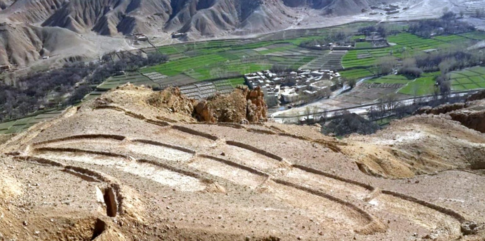
Overview of constructed terraces in the watershed, Saighan district, Bamyan (Shabir Shahem (HELVETAS Swiss Intercooperation, Afghanistan))

Terracing in Watershed (อัฟกานิสถาน)

Kordak dar Abriza

คำอธิบาย

Reshaping unproductive land into a series of levelled, gently-sloping platforms creates conditions suitable for cultivation and prevents accelerated erosion.

The terracing in watershed fact-sheet is documented by Sustainable Land Management Project/HELVETAS Swiss Intercooperation which is funded by Swiss Agency for Development and Cooperation (SDC).
Due to the enduring conflict and to the breakdown of common-pool resources management in upper catchments areas over the past decades, most pastures in Afghanistan are degraded.
Uncontrolled grazing of animals tilling grazing land to grow cereal crops are the main contributors to the loss of vegetation coverage in the upper catchments. One of the negative consequences is repeated flash floods each year causing loss and damage of agriculture lands, gardens, road, canal, infrastructure, houses and even lives. To decrease the severity of flash floods and extend vegetation in upper catchment areas, HELVETAS Swiss Intercooperation in Saighan district has established watershed activities.

Purpose of the Technology: Terrace construction was identified as an effective measure in degraded watershed areas to:
•control runoff and decrease flash flood;
•increase water infiltration;
•create the opportunity for income from cultivation of valuable crops in the terraces.

Establishment / maintenance activities and inputs: Having selected the watersheds and established watershed committees, watershed master plans were prepared and various structural and agronomical measures identified and estimated for each unit of land. Community laborers, trained by HELVETAS technical staff, constructed the terraces under supervision of watershed committee members. 600 terraces, each measuring 10 m x 3.6 m were constructed on seven hectares of land. To ensure maintenance, HELVETAS Swiss Intercooperation facilitated the creation of community saving systems and invested 10% of the project budget for maintenance of each watershed. It improved the capacity of watershed members, so after ending project support the community watershed committee would be able to manage maintenance of watershed measures.


Natural / human environment: Bamyan province is a remote province of Afghanistan with a high poverty rate. It has a semi-arid climate with cold winters and hot and dry summers. During winter, temperatures can drop below -22 degrees. Summer temperatures can reach 34 degrees in the month of July. The average annual rainfall in the area is about 230mm and some years can be very dry. 90% of the population relies on subsistence agriculture for their livelihoods and off-farm activities are marginal. The soil texture is clay, sandy loam and clay loam with moderate type of soil fertility, naked area of upper catchments causes that most of Saighan villages face to water scarcity during May to September and can’t grow valuable crops.The growing season in Saighan district is relatively short from April to October and farmers can produce only one crop per year. Farmers with access to irrigation water cultivate cash crops, for example potato and vegetables, in addition to staple crops (wheat) and fodder crops.Those without access to irrigation water cultivate wheat and fodder crops only. Water scarcity during May to September may result in a lack of high value crops.
The average annual income from one hectare in the area of having enough irrigation water is 250000 AFN (3676 USD) and in the area which has no enough irrigation water is 67500 AFN (992 USD).

สถานที่

สถานที่: Saighan, Bamyan, อัฟกานิสถาน

ตำนวนการวิเคราะห์เทคโนโลยี:

ตำแหน่งทางภูมิศาสตร์ของสถานที่ที่ถูกเลือ
  • n.a.

การเผยแพร่ของเทคโนโลยี: กระจายไปอย่างสม่ำเสมอในพื้นที่ (approx. 1-10 ตร.กม.)

In a permanently protected area?:

วันที่ในการดำเนินการ: น้อยกว่า 10 ปี (ไม่นานนี้)

ประเภทของการแนะนำ
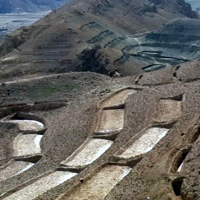
Close view of constructed terraces in the watershed (Shabir Shahem (HELVETAS Swiss Intercooperation, Afghanistan))

การจำแนกประเภทเทคโนโลยี

จุดประสงค์หลัก
  • ปรับปรุงการผลิตให้ดีขึ้น
  • ลด ป้องกัน ฟื้นฟู การเสื่อมโทรมของที่ดิน
  • อนุรักษ์ระบบนิเวศน์
  • ป้องกันพื้นที่ลุ่มน้ำ/บริเวณท้ายน้ำ โดยร่วมกับเทคโนโลยีอื่นๆ
  • รักษาสภาพหรือปรับปรุงความหลากหลายทางชีวภาพ
  • ลดความเสี่ยงของภัยพิบัติ
  • ปรับตัวเข้ากับการเปลี่ยนแปลงภูมิอากาศของโลก สภาพภูมิอากาศที่รุนแรงและผลกระทบ
  • ชะลอการเปลี่ยนแปลงภูมิอากาศของโลกและผลกระทบ
  • สร้างผลกระทบทางด้านเศรษฐกิจที่เป็นประโยชน์
  • สร้างผลกระทบทางด้านสังคมที่เป็นประโยชน์
การใช้ที่ดิน

  • พื้นที่ปลูกพืช
    • การปลูกพืชยืนต้นที่ไม่มีเนื้อไม้
    จำนวนของฤดูเพาะปลูกต่อปี: 1
  • ทุ่งหญ้าเลี้ยงสัตว์
    • การเลี้ยงสัตว์แบบเร่ร่อนไปตามที่ต่าง ๆ (Nomadism)
การใช้น้ำ
  • จากน้ำฝน
  • น้ำฝนร่วมกับการชลประทาน
  • การชลประทานแบบเต็มรูปแบบ

ความมุ่งหมายที่เกี่ยวข้องกับการเสื่อมโทรมของที่ดิน
  • ป้องกันความเสื่อมโทรมของที่ดิน
  • ลดความเสื่อมโทรมของดิน
  • ฟื้นฟูบำบัดที่ดินที่เสื่อมโทรมลงอย่างมาก
  • ปรับตัวกับสภาพความเสื่อมโทรมของที่ดิน
  • ไม่สามารถใช้ได้
ที่อยู่ของการเสื่อมโทรม
  • การกัดกร่อนของดินโดยน้ำ - Wt (Loss of topsoil): การสูญเสียดินชั้นบนหรือการกัดกร่อนที่ผิวดิน
กลุ่ม SLM
  • มาตรการปลูกพืชขวางความลาดชัน (cross-slope measure)
มาตรการ SLM
  • มาตรการอนุรักษ์ด้วยโครงสร้าง - S1: คันดิน

แบบแปลนทางเทคนิค

ข้อมูลจำเพาะด้านเทคนิค
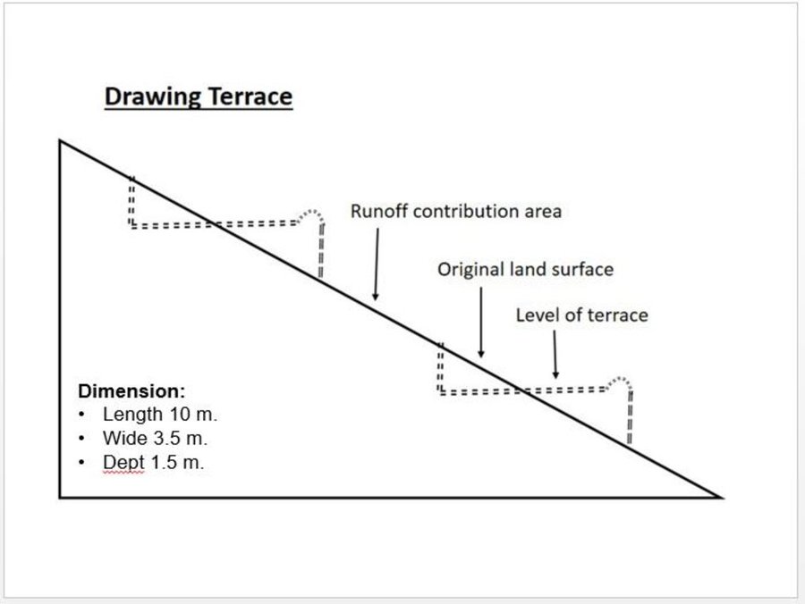
Technical drawing of a terrace built in the watershed for the mean of vegetation.
Almost all the terraces constructed on the hill sides has 10 m length, 3.5 m width and 1.5 m depth.

Location: Saighan. Bamyan

Date: 19/04/2016

Technical knowledge required for field staff / advisors: high (In order to design well)

Technical knowledge required for land users: low

Main technical functions: control of dispersed runoff: impede / retard, reduction of slope angle, reduction of slope length, improvement of topsoil structure (compaction), increase of infiltration, increase / maintain water stored in soil, promotion of vegetation species and varieties (quality, eg palatable fodder)

Terrace: forward sloping
Vertical interval between structures (m): 1.8
Spacing between structures (m): 0.5
Depth of ditches/pits/dams (m): 0.3
Width of ditches/pits/dams (m): 3.6
Length of ditches/pits/dams (m): 10

Construction material (earth): Excuvation of soil and leveling

Slope (which determines the spacing indicated above): 15-30%

If the original slope has changed as a result of the Technology, the slope today is: 0%

Lateral gradient along the structure: 0%

Specification of dams/ pans/ ponds: Capacity 36m3

Catchment area: 36m2
Author: Shabir Shahem, HELVETAS Swiss Intercooperation, Afghanistan

การจัดตั้งและการบำรุงรักษา: กิจกรรม ปัจจัยและค่าใช้จ่าย

การคำนวนต้นทุนและค่าใช้จ่าย
  • ค่าใช้จ่ายถูกคำนวน
  • สกุลเงินที่ใช้คำนวณค่าใช้จ่าย USD
  • อัตราแลกเปลี่ยน (ไปเป็นดอลลาร์สหรัฐ) คือ 1 ดอลลาร์สหรัฐ = ไม่มีคำตอบ
  • ค่าจ้างเฉลี่ยในการจ้างแรงงานต่อวันคือ 5.88
ปัจจัยที่สำคัญที่สุดที่มีผลต่อค่าใช้จ่าย
Labor cost is the determinate factors which was affecting the costs.
กิจกรรมเพื่อการจัดตั้ง
  1. Labor cost for the construction of the terraces (ช่วงระยะเวลา/ความถี่: 1 month)
ปัจจัยและค่าใช้จ่ายของการจัดตั้ง
ปัจจัยนำเข้า หน่วย ปริมาณ ค่าใช้จ่ายต่อหน่วย (USD) ค่าใช้จ่ายทั้งหมดต่อปัจจัยนำเข้า (USD) %ของค่าใช้จ่ายที่ก่อให้เกิดขึ้นโดยผู้ใช้ที่ดิน
แรงงาน
Labor cost for the construction of the terraces persons/day 1200.0 5.88 7056.0 10.0
ค่าใช้จ่ายทั้งหมดของการจัดตั้งเทคโนโลยี 7'056.0
Total costs for establishment of the Technology in USD 7'056.0
กิจกรรมสำหรับการบำรุงรักษา
  1. Repairing of few terraces after heavy rain falls (ช่วงระยะเวลา/ความถี่: 3 times a year)
ปัจจัยและค่าใช้จ่ายของการบำรุงรักษา
ปัจจัยนำเข้า หน่วย ปริมาณ ค่าใช้จ่ายต่อหน่วย (USD) ค่าใช้จ่ายทั้งหมดต่อปัจจัยนำเข้า (USD) %ของค่าใช้จ่ายที่ก่อให้เกิดขึ้นโดยผู้ใช้ที่ดิน
แรงงาน
Repairing of few terraces persons/day 6.0 5.833333 35.0 100.0
ค่าใช้จ่ายทั้งหมดของการบำรุงรักษาสภาพเทคโนโลยี 35.0
Total costs for maintenance of the Technology in USD 35.0

สิ่งแวดล้อมทางธรรมชาติ

ปริมาณน้ำฝนเฉลี่ยรายปี
  • < 250 ม.ม.
  • 251-500 ม.ม.
  • 501-750 ม.ม.
  • 751-1,000 ม.ม.
  • 1,001-1,500 ม.ม.
  • 1,501-2,000 ม.ม.
  • 2,001-3,000 ม.ม.
  • 3,001-4,000 ม.ม.
  • > 4,000 ม.ม.
เขตภูมิอากาศเกษตร
  • ชื้น
  • กึ่งชุ่มชื้น
  • กึ่งแห้งแล้ง
  • แห้งแล้ง
ข้อมูลจำเพาะเรื่องภูมิอากาศ
Thermal climate class: temperate
ความชัน
  • ราบเรียบ (0-2%)
  • ลาดที่ไม่ชัน (3-5%)
  • ปานกลาง (6-10%)
  • เป็นลูกคลื่น (11-15%)
  • เป็นเนิน (16-30%)
  • ชัน (31-60%)
  • ชันมาก (>60%)
ภูมิลักษณ์
  • ที่ราบสูง/ที่ราบ
  • สันเขา
  • ไหล่เขา
  • ไหล่เนินเขา
  • ตีนเนิน
  • หุบเขา
ความสูง
  • 0-100 เมตร
  • 101-500 เมตร
  • 501-1,000 เมตร
  • 1,001-1,500 เมตร
  • 1,501-2,000 เมตร
  • 2,001-2,500 เมตร
  • 2,501-3,000 เมตร
  • 3,001-4,000 เมตร
  • > 4,000 เมตร
เทคโนโลยีถูกประยุกต์ใช้ใน
  • บริเวณสันเขา (convex situations)
  • บริเวณแอ่งบนที่ราบ (concave situations)
  • ไม่เกี่ยวข้อง
ความลึกของดิน
  • ตื้นมาก (0-20 ซ.ม.)
  • ตื้น (21-50 ซ.ม.)
  • ลึกปานกลาง (51-80 ซ.ม.)
  • ลึก (81-120 ซ.ม.)
  • ลึกมาก (>120 ซ.ม.)
เนื้อดิน (ดินชั้นบน)
  • หยาบ/เบา (ดินทราย)
  • ปานกลาง (ดินร่วน ทรายแป้ง)
  • ละเอียด/หนัก (ดินเหนียว)
เนื้อดิน (> 20 ซม. ต่ำกว่าพื้นผิว)
  • หยาบ/เบา (ดินทราย)
  • ปานกลาง (ดินร่วน ทรายแป้ง)
  • ละเอียด/หนัก (ดินเหนียว)
สารอินทรียวัตถุในดิน
  • สูง (>3%)
  • ปานกลาง (1-3%)
  • ต่ำ (<1%)
น้ำบาดาล
  • ที่ผิวดิน
  • <5 เมตร
  • 5-50 เมตร
  • > 50 เมตร
ระดับน้ำบาดาลที่ผิวดิน
  • เกินพอ
  • ดี
  • ปานกลาง
  • ไม่ดีหรือไม่มีเลย
คุณภาพน้ำ (ยังไม่ได้รับการบำบัด)
  • เป็นน้ำเพื่อการดื่มที่ดี
  • เป็นน้ำเพื่อการดื่มที่ไม่ดี (จำเป็นต้องได้รับการบำบัด)
  • เป็นน้ำใช้เพื่อการเกษตรเท่านั้น (การชลประทาน)
  • ใช้ประโยชน์ไม่ได้
Water quality refers to:
ความเค็มของน้ำเป็นปัญหาหรือไม่?
  • ใช่
  • ไม่ใช่

การเกิดน้ำท่วม
  • ใช่
  • ไม่ใช่
ความหลากหลายทางชนิดพันธุ์
  • สูง
  • ปานกลาง
  • ต่ำ
ความหลากหลายของแหล่งที่อยู่
  • สูง
  • ปานกลาง
  • ต่ำ

ลักษณะเฉพาะของผู้ใช้ที่ดินที่ประยุกต์ใช้เทคโนโลยี

เป้าหมายทางการตลาด
  • เพื่อการยังชีพ (หาเลี้ยงตนเอง)
  • mixed (subsistence/ commercial)
  • ทำการค้า/การตลาด
รายได้จากภายนอกฟาร์ม
  • < 10% ของรายได้ทั้งหมด
  • 10-50% ของรายได้ทั้งหมด
  • > 50% ของรายได้ทั้งหมด
ระดับของความมั่งคั่งโดยเปรียบเทียบ
  • ยากจนมาก
  • จน
  • พอมีพอกิน
  • รวย
  • รวยมาก
ระดับของการใช้เครื่องจักรกล
  • งานที่ใช้แรงกาย
  • การใช้กำลังจากสัตว์
  • การใช้เครื่องจักรหรือเครื่องยนต์
อยู่กับที่หรือเร่ร่อน
  • อยู่กับที่
  • กึ่งเร่ร่อน
  • เร่ร่อน
เป็นรายบุคคลหรือกลุ่ม
  • เป็นรายบุคคล/ครัวเรือน
  • กลุ่ม/ชุมชน
  • สหกรณ์
  • ลูกจ้าง (บริษัท รัฐบาล)
เพศ
  • หญิง
  • ชาย
อายุ
  • เด็ก
  • ผู้เยาว์
  • วัยกลางคน
  • ผู้สูงอายุ
พื้นที่ที่ใช้ต่อครัวเรือน
  • < 0.5 เฮกตาร์
  • 0.5-1 เฮกตาร์
  • 1-2 เฮกตาร์
  • 2-5 เฮกตาร์
  • 5-15 เฮกตาร์
  • 15-50 เฮกตาร์
  • 50-100 เฮกตาร์
  • 100-500 เฮกตาร์
  • 500-1,000 เฮกตาร์
  • 1,000-10,000 เฮกตาร์
  • >10,000 เฮกตาร์
ขนาด
  • ขนาดเล็ก
  • ขนาดกลาง
  • ขนาดใหญ่
กรรมสิทธิ์ในที่ดิน
  • รัฐ
  • บริษัท
  • เป็นแบบชุมชนหรือหมู่บ้าน
  • กลุ่ม
  • รายบุคคล ไม่ได้รับสิทธิครอบครอง
  • รายบุคคล ได้รับสิทธิครอบครอง
สิทธิในการใช้ที่ดิน
  • เข้าถึงได้แบบเปิด (ไม่ได้จัดระเบียบ)
  • เกี่ยวกับชุมชน (ถูกจัดระเบียบ)
  • เช่า
  • รายบุคคล
สิทธิในการใช้น้ำ
  • เข้าถึงได้แบบเปิด (ไม่ได้จัดระเบียบ)
  • เกี่ยวกับชุมชน (ถูกจัดระเบียบ)
  • เช่า
  • รายบุคคล
เข้าถึงการบริการและโครงสร้างพื้นฐาน
สุขภาพ

จน
x
ดี
การศึกษา

จน
x
ดี
ความช่วยเหลือทางด้านเทคนิค

จน
x
ดี
การจ้างงาน (เช่น ภายนอกฟาร์ม)

จน
x
ดี
ตลาด

จน
x
ดี
พลังงาน

จน
x
ดี
ถนนและการขนส่ง

จน
x
ดี
น้ำดื่มและการสุขาภิบาล

จน
x
ดี
บริการด้านการเงิน

จน
x
ดี

ผลกระทบ

ผลกระทบทางด้านเศรษฐกิจและสังคม
การผลิตพืชผล
ลดลง
x
เพิ่มขึ้น

จำนวนก่อน SLM: 60
หลังจาก SLM: 80
Technology reduce flood and lower lands doesnt effect by floods

การมีน้ำไว้ให้สำหรับการชลประทาน
ลดลง
x
เพิ่มขึ้น

จำนวนก่อน SLM: 20
หลังจาก SLM: 25
Increasing under ground water by applying technology

รายได้จากฟาร์ม
ลดลง
x
เพิ่มขึ้น

จำนวนก่อน SLM: 0
หลังจาก SLM: 50
Cultivation of cash crop in the terraces (farm income from uplands)

ผลกระทบด้านสังคมและวัฒนธรรม
ความมั่นคงด้านอาหาร / พึ่งตนเองได้
ลดลง
x
ปรับปรุงดีขึ้น

SLM หรือความรู้เรื่องความเสื่อมโทรมของที่ดิน
ลดลง
x
ปรับปรุงดีขึ้น

การบรรเทาความขัดแย้ง
แย่ลง
x
ปรับปรุงดีขึ้น

สถานการณ์ของกลุ่มด้อยโอกาส ทางด้านสังคมและเศรษฐกิจ (เพศ อายุ สถานภาพ ความเป็นกลุ่มทางชาติพันธุ์)
แย่ลง
x
ปรับปรุงดีขึ้น

livelihood and human well-being
reduced
x
improved


The technology has effective role on reducing flash flood and as well through cultivation of valuable crops the community get more income from watershed area

ผลกระทบด้านนิเวศวิทยา
การเก็บเกี่ยวหรือการกักเก็บน้ำ (น้ำค้างหิมะ)
ลดลง
x
ปรับปรุงดีขึ้น

น้ำไหลบ่าที่ผิวดิน
เพิ่มขึ้น
x
ลดลง

จำนวนก่อน SLM: 0
หลังจาก SLM: 100
Leveled terraces infilter the water

น้ำบาดาลหรือระดับน้ำในแอ่งน้ำบาดาล
ต่ำลง
x
ซึมลงเติม

ความชื้นในดิน
ลดลง
x
เพิ่มขึ้น

จำนวนก่อน SLM: 0
หลังจาก SLM: 50
Technology let the water infilteration more

สิ่งปกคลุมดิน
ลดลง
x
ปรับปรุงดีขึ้น

การสูญเสียดิน
เพิ่มขึ้น
x
ลดลง

ผลกระทบนอกพื้นที่ดำเนินการ
น้ำที่ใช้ประโยชน์ได้ (น้ำบาดาล น้ำพุ)
ลดลง
x
เพิ่มขึ้น

น้ำท่วมพื้นที่ท้ายน้ำ (ที่ไม่เป็นที่ต้องการ)
เพิ่มขึ้น
x
ลดลง

จำนวนก่อน SLM: 0
หลังจาก SLM: 50
Control runoff

รายได้และค่าใช้จ่าย

ผลประโยชน์ที่ได้รับเปรียบเทียบกับค่าใช้จ่าย
ผลตอบแทนระยะสั้น
ด้านลบอย่างมาก
x
ด้านบวกอย่างมาก

ผลตอบแทนระยะยาว
ด้านลบอย่างมาก
x
ด้านบวกอย่างมาก

ผลประโยชน์ที่ได้รับเปรียบเทียบกับค่าใช้จ่ายในการบำรุงรักษา
ผลตอบแทนระยะสั้น
ด้านลบอย่างมาก
x
ด้านบวกอย่างมาก

ผลตอบแทนระยะยาว
ด้านลบอย่างมาก
x
ด้านบวกอย่างมาก

The establishment cost of this technology seems to be high but once they are built they need very less maintenance cost with lots of benefits in the other hand.

การเปลี่ยนแปลงของสภาพภูมิอากาศ

การเปลี่ยนแปลงสภาพภูมิอากาศที่ค่อยเป็นค่อยไป
อุณหภูมิประจำปี เพิ่มขึ้น

ไม่ดี
x
ดีมาก
สภาพรุนแรงของภูมิอากาศ (ภัยพิบัติ)
พายุฝนประจำท้องถิ่น

ไม่ดี
x
ดีมาก
ภัยจากฝนแล้ง

ไม่ดี
x
ดีมาก
น้ำท่วมตามปกติ (แม่น้ำ)

ไม่ดี
x
ดีมาก

การน้อมเอาความรู้และการปรับใช้

เปอร์เซ็นต์ของผู้ใช้ที่ดินในพื้นที่ที่นำเทคโนโลยีไปใช้
  • ครั้งเดียวหรือเป็นการทดลอง
  • 1-10%
  • 11-50%
  • > 50%
จากทั้งหมดที่ได้รับเทคโนโลยีเข้ามามีจำนวนเท่าใดที่ทำแบบทันที โดยไม่ได้รับการจูงใจด้านวัสดุหรือการเงินใดๆ?
  • 0-10%
  • 11-50%
  • 51-90%
  • 91-100%
จำนวนหลังคาเรือนหรือขนาดพื้นที่รวมทั้งหมด
444 households covering 100 percent of the stated area
เทคโนโลยีได้รับการปรับเปลี่ยนเร็วๆ นี้เพื่อให้ปรับตัวเข้ากับสภาพที่กำลังเปลี่ยนแปลงหรือไม่?
  • ใช่
  • ไม่ใช่
สภาพที่กำลังเปลี่ยนแปลงอันไหน?
  • การเปลี่ยนแปลงแบบค่อยเป็นค่อยไปและสภาพรุนแรงของภูมิอากาศ
  • การเปลี่ยนแปลงของตลาด
  • การมีแรงงานไว้ให้ใช้ (เนื่องจากการอพยพย้ายถิ่นฐาน)

บทสรุปหรือบทเรียนที่ได้รับ

จุดแข็ง: มุมมองของผู้ใช้ที่ดิน
  • Good measure that is easy to be applied by the people.

    How can they be sustained / enhanced? Conducting training and workshops for capacity building of the community members.
  • The application of this technology results to the control of runoff and reduction of the flash flood.

    How can they be sustained / enhanced? More vegetative measures should be considered.
จุดแข็ง: ทัศนคติของผู้รวบรวมหรือวิทยากรคนอื่นๆ
  • A good technology for the better control of runoff and keeping the moisture.

    How can they be sustained / enhanced? Cultivation and sustainable maintenance of the plants in the terraces.
  • Preparing and providing a good and proper place for cultivation and plantation.

    How can they be sustained / enhanced? Plantation of the local plants which has more resistance and are adaptable to the natural environment of Saighan district.
  • Getting more income through cultivation of valuable crops.

    How can they be sustained / enhanced? Protection of cultivated seed from grazing animals
จุดด้อย/ข้อเสีย/ความเสี่ยง: มุมมองของผู้ใช้ที่ดินแก้ไขปัญหาได้อย่างไร
จุดด้อย/ข้อเสีย/ความเสี่ยง: ทัศนคติของผู้รวบรวมหรือวิทยากรคนอื่นๆแก้ไขปัญหาได้อย่างไร
  • Requires high investment and financial cost. People should as well have contribution in the cost by providing the labor work.
  • In case the technical measures are not considered and applied properly it may increase infiltration and subsequently increases the soil moisture which may trigger landslide on slopes during rainfalls High level of the technical staff and knowledge to be considered and as well the area should be studied and observed deeply.

การอ้างอิง

ผู้รวบรวม
  • Aqila Haidery
Editors
ผู้ตรวจสอบ
  • David Streiff
  • Alexandra Gavilano
วันที่จัดทำเอกสาร: 19 เมษายน 2016
การอัพเดทล่าสุด: 11 มีนาคม 2019
วิทยากร
คำอธิบายฉบับเต็มในฐานข้อมูล WOCAT
ข้อมูล SLM ที่ถูกอ้างอิง
การจัดทำเอกสารถูกทำโดย
องค์กร โครงการ
This work is licensed under Creative Commons Attribution-NonCommercial-ShareaAlike 4.0 International