Participatory Understanding of Groundwater Dynamics: Threats and Responsive Management [อินเดีย]
- ผู้สร้างสรรค์:
- การอัพเดท:
- ผู้รวบรวม: Pratik Ramteke
- ผู้เรียบเรียง: –
- ผู้ตรวจสอบ: Rima Mekdaschi Studer, William Critchley
CDVI 3D Model
approaches_7555 - อินเดีย
ดูส่วนย่อย
ขยายทั้งหมด ย่อทั้งหมด1. ข้อมูลทั่วไป
1.2 รายละเอียดที่ติดต่อได้ของผู้รวบรวมและองค์กรที่เกี่ยวข้องในการประเมินและการจัดเตรียมทำเอกสารของแนวทาง
ผู้ใช้ที่ดิน:
Yadav Ankita
ankita.yadav@wotr.org.in
Watershed Organisation Trust (WOTR), Pune
อินเดีย
ผู้ใช้ที่ดิน:
Ghodake Navnath
navnath.ghodake@wotr.org.in
Watershed Organisation Trust (WOTR), Pune
อินเดีย
1.3 เงื่อนไขที่เกี่ยวข้องกับการใช้ข้อมูลที่ได้บันทึกไว้ผ่านทาง WOCAT
วันที่เก็บรวบรวมข้อมูล (ภาคสนาม):
30/04/2021
ผู้รวบรวมและวิทยากรหลักยอมรับเงื่อนไขเกี่ยวกับการใช้ข้อมูลที่ถูกบันทึกผ่านทาง WOCAT:
ใช่
2. คำอธิบายของแนวทาง SLM
2.1 การอธิบายแบบสั้น ๆ ของแนวทาง
CoDriVE-VI is a participatory approach that integrates local knowledge with scientific data through 3D visual modelling to assess groundwater vulnerability and support sustainable, community-based groundwater management. It overlays surface and subsurface features, enabling villagers to visualize aquifer systems and develop informed water use plans.
2.2 การอธิบายอย่างละเอียดของแนวทาง
การอธิบายอย่างละเอียดของแนวทาง:
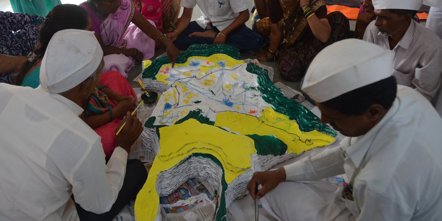
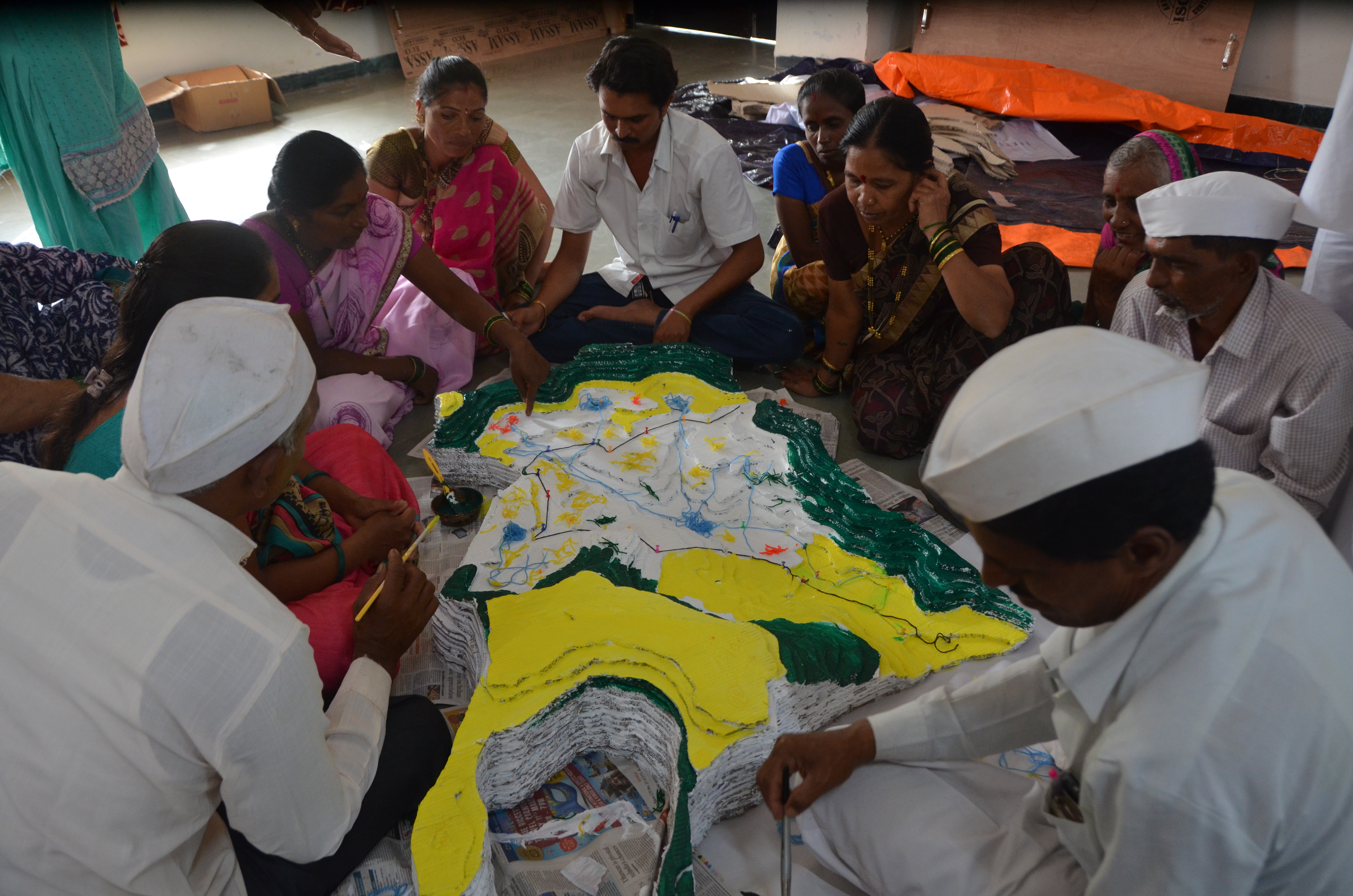
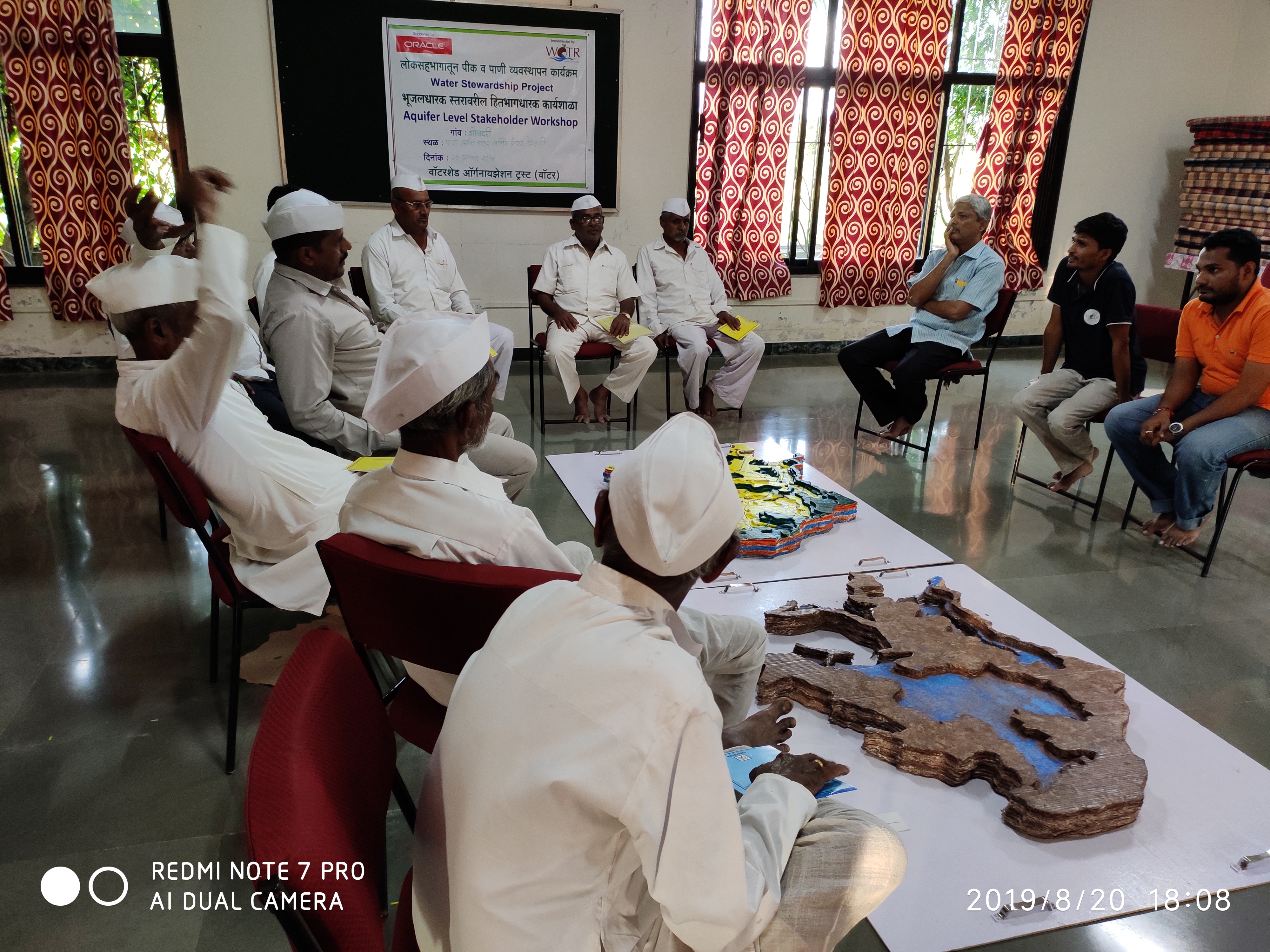
CoDriVE-VI (Community-driven Vulnerability Evaluation – Visual Integrator) is a participatory approach developed by the Watershed Organisation Trust (WOTR) to support sustainable groundwater management. It aims to demystify the invisible subsurface and make aquifer systems understandable to rural communities by combining scientific tools with local knowledge in a hands-on, visual format. While the process is facilitated by WOTR, communities are placed at the center of the process, contributing traditional insights, assisting with data collection, and actively participating in constructing and interpreting the 3D model. Thus, the approach is best described as participatory, with strong elements of community ownership and engagement.
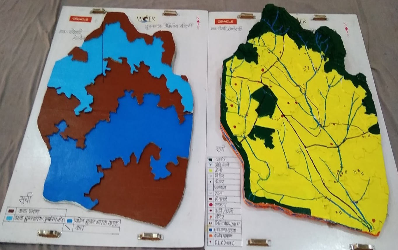
The “Visual Integrator” refers to the integration of both surface and subsurface data—such as topography, drainage, geology, well inventory details, and geophysical survey results—into a tangible, scaled three-dimensional model. This participatory 3D modelling (P3DM) process helps communities visualize how aquifers relate to the landscape, showing key features such as recharge zones, discharge points, and areas of intensive groundwater extraction.
“Vulnerability evaluation” is carried out through the community’s participatory analysis of the model. Using the integrated visual platform, villagers can identify zones that are more vulnerable to depletion—such as those with low recharge, high borewell density, or historically declining water tables. While a formal vulnerability matrix is not used, the 3D model serves as a practical vulnerability map. It guides discussions and decisions around water budgeting, aquifer recharge, crop-water planning, and the development of informal rules for responsible groundwater use.
The methodology combines participatory rural appraisal with hydrogeological and geospatial techniques. After an initial orientation and trust-building phase, communities help map surface features. Subsurface data is then collected through geological mapping, well inventory surveys, and geophysical methods like Vertical Electrical Sounding (VES). The data are analyzed using GIS tools and inverse slope modelling. The 3D model is then constructed using layered cardboard sheets, with communities contributing throughout the process—cutting, assembling, painting, and validating the layers.
The CoDriVE-VI process unfolds in several stages: community mobilization and planning; surface and subsurface data collection; model building in participatory workshops; and result interpretation and management planning. Key stakeholders include community members, WOTR facilitators, technical experts (geologists and GIS specialists), and local governance representatives.
Participants found the visual models highly effective in helping them grasp aquifer dynamics, leading to a shift in perception—from seeing groundwater as an individual entitlement to recognizing it as a shared resource. This in turn fostered collective decision-making. The approach has also contributed to improved groundwater literacy, informed water budgeting, and motivated some villages to initiate local groundwater governance practices.
While climate change is a key driver of groundwater stress, the approach also acknowledges other socio-economic and environmental pressures—such as population growth, land-use change, deforestation, and the uncontrolled proliferation of borewells—as critical factors influencing groundwater vulnerability. By visualizing these interconnections, CoDriVE-VI supports more holistic and sustainable groundwater management at the community level.
2.3 รูปภาพของแนวทาง
อัลบั้มสื่อบันทึก
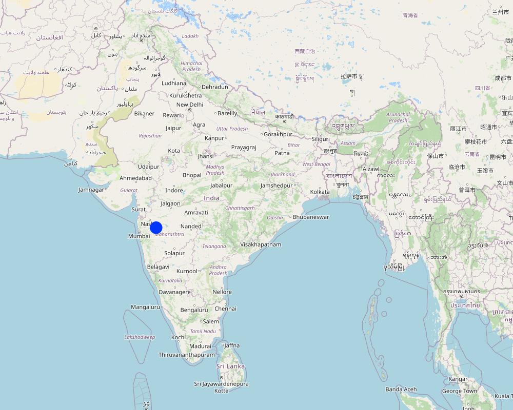
2.5 ประเทศ ภูมิภาค หรือสถานที่ตั้งที่ได้นำแนวทางไปใช้
ประเทศ:
อินเดีย
ภูมิภาค/รัฐ/จังหวัด: :
Maharashtra
ข้อมูลเฉพาะเพิ่มเติมของสถานที่ตั้ง:
Darewadi,Post. Kauthe Malkapur Tal. Sangamner, Dist. Ahilyanagar, Maharashtra
Map
×2.6 วันที่เริ่มต้นและสิ้นสุดของแนวทาง
ระบุปีที่เริ่ม:
2017
ความคิดเห็น:
The tool was developed based on experiences from multiple village-level implementations in Maharashtra. The approach is ongoing.
2.8 เป้าหมายหรือวัตถุประสงค์หลักของแนวทาง
1. To build the capacity of rural communities to understand groundwater systems, including aquifer behavior and climate and non-climate stressors affecting groundwater availability.
2. To make subsurface aquifer characteristics visible and comprehensible through participatory 3D modelling that integrates scientific and local knowledge.
3. To foster collective ownership and sustainable management of groundwater as a shared, finite resource.
4. To support community-led evaluation of groundwater vulnerability and guide responsive actions such as water budgeting and recharge planning.
5. To document, preserve, and apply indigenous spatial knowledge related to land use, topography, and local water systems.
6. To enable informed decision-making by facilitating the transfer of community-generated insights to local governance bodies and development agencies.
2.9 เงื่อนไขที่เอื้ออำนวยหรือเป็นอุปสรรคต่อการนำเทคโนโลยีภายใต้แนวทางนี้ไปปฏิบัติใช้
บรรทัดฐานและค่านิยมทางสังคม วัฒนธรรม ศาสนา
- เอื้ออำนวย
The participatory nature of CoDriVE aligns well with community-based traditions and values. Villagers appreciated visual models and collective dialogue.
การมีไว้ให้หรือการเข้าถึงแหล่งการเงินและบริการ
- เป็นอุปสรรค
Physical model preparation and technical surveys (like geophysical VES) require resources. Financial constraints can limit replication or scaling.
การจัดตั้งระดับองค์กร
- เอื้ออำนวย
Support from institutions like WOTR and local governance structures helped facilitate workshops and technical assessments.
การร่วมมือหรือการทำงานประสานกันของผู้ลงมือปฏิบัติ
- เอื้ออำนวย
Strong collaboration between communities, facilitators, technical experts, and local leaders enabled smooth implementation
กรอบแนวทางในการดำเนินการด้านกฎหมาย (การถือครองที่ดิน สิทธิในการใช้ที่ดินและน้ำ)
- เป็นอุปสรรค
Customary laws viewing groundwater as private property can hinder the recognition of aquifers as shared resources.
นโยบาย
- เอื้ออำนวย
National and state-level programs like Atal Bhujal Yojana and Maharashtra Groundwater Act 2009 support aquifer-based planning and groundwater literacy.
การกำกับดูแลที่ดิน (การตัดสินใจ การนำเอาไปปฏิบัติใช้ และการบังคับใช้)
- เอื้ออำนวย
Local institutions and village-level bodies were engaged in discussions and planning.
ความรู้เกี่ยวกับ SLM การเข้าถึงการสนับสนุนด้านเทคนิค
- เอื้ออำนวย
Technical support from WOTR and use of local knowledge supported learning and capacity building
ตลาด (จัดซื้อปัจจัยนำเข้า ขายผลิตภัณฑ์) และราคา
- เอื้ออำนวย
ปริมาณงานที่ทำได้ กำลังคนที่มีให้
- เอื้ออำนวย
Community enthusiasm and involvement were high during workshops and model building.
- เป็นอุปสรรค
Manual preparation of 3D models requires time and coordination, which may be demanding in some villages.
อื่นๆ
- เอื้ออำนวย
Visual and tactile tools helped bridge the knowledge gap between experts and villagers.
- เป็นอุปสรรค
Initial complexity of scientific terms (e.g., aquifer, resistivity) required careful facilitation and adaptation
3. การมีส่วนร่วมและบทบาทของผู้มีส่วนได้ส่วนเสียที่เกี่ยวข้อง
3.1 ผู้มีส่วนได้ส่วนเสียที่เกี่ยวข้องในแนวทางนี้และบทบาท
- ผู้ใช้ที่ดินระดับท้องถิ่นหรือชุมชนระดับท้องถิ่น
Villagers and farmers from Ahilyanagar and Jalna districts, Maharashtra
They participated actively in the mapping exercises, provided indigenous knowledge on topography and land use, contributed to well inventory and aquifer-related insights, and were directly involved in building the 3D models. Their engagement was central in interpreting subsurface information and applying it to groundwater planning.
- องค์กรที่ขึ้นอยู่กับชุมชน
Village Water Management Committees, Water Stewardship groups
Helped mobilize community members, facilitated communication between villagers and technical teams, and supported local-level planning and rule-setting for groundwater use.
- ผู้เชี่ยวชาญ SLM หรือที่ปรึกษาการเกษตร
WOTR technical staff and hydrogeology facilitators
Provided scientific inputs on geology and hydrogeology, conducted well and geophysical surveys, interpreted data, supported the construction of groundwater potential maps, and trained community members in groundwater management
- นักวิจัย
Researchers and field investigators from WOTR and contributing institutions
Developed the methodology, documented experiences, synthesised scientific and community knowledge, and analysed feedback for continuous improvement of the tool.
- องค์กรพัฒนาเอกชน
Watershed Organisation Trust (WOTR)
Lead agency responsible for conceptualizing, facilitating, implementing, and documenting the approach. Conducted workshops, managed technical assessments, trained field teams, and engaged communities.
- ภาคเอกชน
HSBC Software Development India (as supporter)
Provided financial support for printing and disseminating the CoDriVE-VI manual.
- รัฐบาลระดับท้องถิ่น
Gram Panchayat members, Sarpanches
Participated in workshops, helped validate maps and data, encouraged community participation, and supported local rule-making for sustainable groundwater use.
- รัฐบาลแห่งชาติ (ผู้วางแผน ผู้ทำการตัดสินใจ)
Indirectly linked via supportive policies (e.g., Atal Bhujal Yojana, National Aquifer Management Project (NAQUIM))
Although not directly involved in implementation, national policies provided support for the overall context and justification of aquifer-based participatory planning and water budgeting.
- องค์การระหว่างประเทศ
ProSoil project (GIZ)
Supported in publishing and promoting the CoDriVE-VI manual, including showcasing it at UNCCD COP14
ถ้ามีผู้มีส่วนได้ส่วนเสียหลายคนที่เกี่ยวข้องให้ระบุหน่วยงานตัวแทน:
Watershed Organisation Trust (WOTR)
3.2 การเกี่ยวข้องของผู้ใช้ที่ดินระดับท้องถิ่นหรือชุมชนระดับท้องถิ่นในช่วงต่างๆของแนวทาง
| ความเกี่ยวข้องของผู้ใช้ที่ดินระดับท้องถิ่นหรือชุมชนระดับท้องถิ่น | ระบุผู้ที่มีส่วนเกี่ยวข้องและอธิบายกิจกรรม | |
|---|---|---|
| การริเริ่มหรือการจูงใจ | ปฏิสัมพันธ์ | Local villagers in the project areas (e.g., Ahilyanagar and Jalna districts) were engaged early through orientation sessions. While the initiative was introduced by WOTR, community members showed interest and contributed knowledge from the beginning, especially around their water challenges and local hydrogeology. |
| การวางแผน | ปฏิสัมพันธ์ | Villagers participated in identifying key features for surface mapping, shared traditional knowledge of aquifers and land use, and were involved in selecting locations for surveys. Their inputs shaped both the design and scale of the models. |
| การดำเนินการ | ปฏิสัมพันธ์ | Community members took part in well inventory surveys, guided geological observations, and actively built the 3D physical models. They also helped colour-code aquifer zones under facilitators’ guidance, and validated the data presented. |
| การติดตามตรวจสอบหรือการประเมินผล | ปฏิสัมพันธ์ | During workshops and feedback sessions, villagers evaluated the accuracy of models, reflected on the implications of subsurface characteristics, and discussed how to use the insights for water budgeting and community planning |
| research | Community knowledge directly contributed to the research process by enriching scientific interpretations with local hydrogeological understanding. Their experiences and reflections were documented and used to improve the approach. |
3.3 แผนผังแสดงขั้นตอนการทำงาน (ถ้ามี)
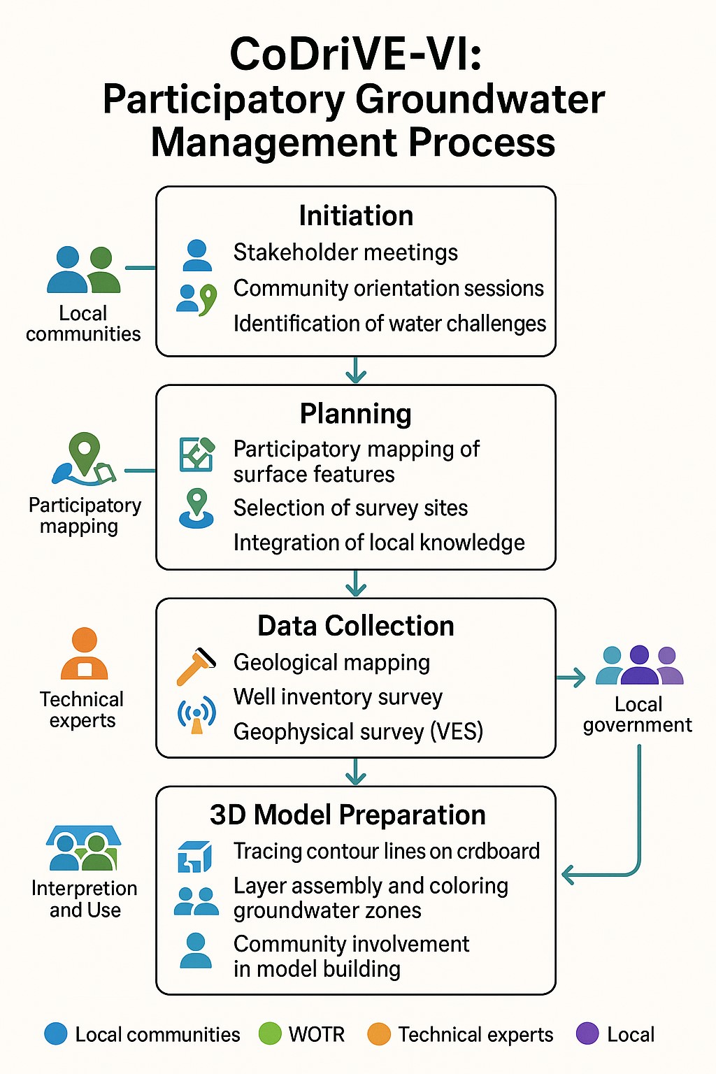
คำอธิบาย:
The visual summary illustrates the four key stages of the CoDriVE-VI approach
Initiation
-Stakeholder meetings and community orientation sessions are conducted.
-Local water-related challenges are identified.
-Builds a foundation for participatory engagement and problem recognition.
Planning
-Participatory mapping of surface features is carried out.
-Survey sites are selected based on local inputs and technical feasibility.
-Local knowledge is integrated with scientific planning.
Data Collection
-Technical experts conduct geological mapping and well inventory surveys.
- Geophysical surveys (e.g., Vertical Electrical Sounding - VES) are performed.
- Scientific data on groundwater systems is gathered for model development.
3D Model Preparation
-Contour lines are traced on cardboard to build physical models.
-Groundwater zones are assembled and color-coded.
-Communities are actively involved in model building and interpretation for better understanding and use.
ผู้เขียน:
Pratik Ramteke
3.4 การตัดสินใจเลือกใช้เทคโนโลยี SLM
ระบุผู้ที่ทำการตัดสินใจเลือกเทคโนโลยีมากกว่าหนึ่งวิธีไปปฏิบัติใช้:
- ผู้ลงมือปฏิบัติที่เกี่ยวข้องทั้งหมดในฐานะที่เป็นส่วนรวมของแนวทาง
การอธิบาย:
The selection and design of the CoDriVE tool was done through participatory processes involving local communities, WOTR facilitators, and technical experts. Villagers contributed local knowledge and needs, while experts provided scientific input, ensuring collective decision-making.
ระบุว่าการตัดสินใจตั้งอยู่บนพื้นฐานของ:
- การประเมินความรู้ SLM ที่ได้ทำการบันทึกไว้เป็นอย่างดี (การใช้ข้อมูลในการตัดสินใจ)
- สิ่งที่ค้นพบจากงานวิจัย
- ประสบการณ์และความคิดเห็นส่วนตัว (ไม่ได้ลงบันทึกไว้)
- Decisions were based on field experiences from over 25 villages, scientific methods (e.g., VES surveys, GIS analysis), and documented evidence on aquifer-based planning. Local knowledge and experiential insights also guided model design and validation.
4. การสนับสนุนด้านเทคนิค การสร้างขีดความสามารถ และการจัดการด้านความรู้
4.1 การสร้างขีดความสามารถ / การอบรม
ได้มีการจัดอบรมให้แก่ผู้ใช้ที่ดินหรือผู้มีส่วนได้ส่วนเสียคนอื่น ๆ หรือไม่:
ใช่
ให้ระบุว่าใครเป็นผู้ได้รับการอบรม:
- ผู้ใช้ที่ดิน
- เจ้าหน้าที่ภาคสนาม / ที่ปรึกษา
ถ้าเกี่ยวข้อง ให้ระบุ เพศ อายุ สถานภาพ ชาติพันธุ์ เป็นต้น:
Training involved both male and female community members, including farmers, youth, and local leaders from diverse socio-economic backgrounds in the villages. Inclusive participation was encouraged throughout
รูปแบบการอบรม:
- กำลังดำเนินการ
- เกษตรกรกับเกษตรกร
- ใช้พื้นที่ทำการสาธิต
- จัดการประชุมสู่สาธารณชน
หัวข้อที่พูด:
•Basic concepts of hydrogeology and aquifers
•Groundwater vulnerability and common pool resource concepts
•Surface and subsurface mapping
•Use of Participatory 3D Modelling (P3DM)
•Groundwater budgeting
•Climate change impacts on water resources
•Community-led planning and rule-setting for water use
4.2 การบริการให้คำแนะนำ
ผู้ใช้ที่ดินมีการเข้าถึงการรับบริการให้คำปรึกษาหรือไม่:
ใช่
ระบุว่ามีบริการให้คำปรึกษาหรือไม่:
- ไปเยี่ยมชมสถานที่
- ที่ศูนย์ถาวร
การอธิบาย/แสดงความคิดเห็น:
WOTR provided technical assistance through facilitators and hydrogeology experts. These acted as advisors, guiding communities in surveys, model interpretation, and decision-making.
4.3 การเสริมความแข็งแกร่งให้กับสถาบัน (การพัฒนาองค์กร)
สถาบันได้รับการจัดตั้งขึ้นมาหรือเสริมความแข็งแกร่งโดยแนวทางนี้หรือไม่:
- ใช่ ปานกลาง
ระบุระดับของสถาบันที่ได้รับการเสริมความแข็งแกร่งหรือจัดตั้งขึ้นมา:
- ท้องถิ่น
อธิบายถึงสถาบัน บทบาทและความรับผิดชอบ สมาชิก เป็นต้น:
Village Water User Groups (VWUGs) and local governance committees were strengthened to coordinate groundwater management activities. Their roles included planning water use, monitoring aquifer health, implementing community water rules, and facilitating knowledge sharing. Members typically included local farmers, community leaders, and field facilitators
ระบุประเภทของการให้ความช่วยเหลือสนับสนุน:
- การสร้างขีดความสามารถ / การอบรม
- อุปกรณ์
ให้รายละเอียดเพิ่มเติม :
The strengthening focused on enhancing institutional capacity to support community-driven water resource management. Training sessions improved leadership and technical skills, enabling institutions to take ownership of groundwater sustainability. Equipment such as GPS units and simple monitoring devices were provided to aid local data collection and verification.
4.4 การติดตามตรวจสอบและประเมินผล
การติดตามตรวจสอบและประเมินผลเป็นส่วนหนึ่งของแนวทางหรือไม่:
ใช่
ความคิดเห็น:
Monitoring was integrated through periodic community workshops, feedback sessions, and participatory verification of groundwater models. Evaluation focused on assessing the accuracy of aquifer mapping, effectiveness of capacity building, and impact on local water management practices.
ถ้าตอบว่าใช่ แสดงว่าการจัดเตรียมเอกสารนี้มุ่งหวังที่จะเอาไปใช้สำหรับการติดตามตรวจสอบและประเมินผลใช่หรือไม่:
ใช่
ความคิดเห็น:
This documentation serves as a reference for tracking the implementation process, assessing community engagement, and evaluating outcomes. It can be used to guide adaptive management and inform replication in other regions.
4.5 การวิจัย
การวิจัยเป็นส่วนหนึ่งของแนวทางหรือไม่:
ใช่
ระบุหัวข้อเรื่อง:
- สังคมวิทยา
- นิเวศวิทยา
- เทคโนโลยี
- Hydrogeology and participatory modelling
ให้ข้อมูลเพิ่มเติมและให้ระบุผู้ทำการวิจัย:
Research was integral to developing and refining the CoDriVE methodology. Hydrogeologists and social scientists collaborated with local communities to understand groundwater systems and social dynamics influencing water use. Technology research focused on participatory 3D modeling tools and groundwater budgeting techniques. WOTR staff, partnered with academic institutions and experts in hydrogeology, led the research activities. Community feedback was also systematically documented to improve approaches.
5. การสนับสนุนด้านการเงินและวัสดุอุปกรณ์
5.1 ระบุงบประมาณประจำปีสำหรับแนวทาง SLM นี้
ถ้าหากว่างบประมาณประจำปีไม่เป็นที่ทราบแน่นอน ให้ระบุช่วงลงไป:
- 10,000-100,000
แสดงความคิดเห็น (แหล่งของการระดมทุน ผู้บริจาคคนสำคัญ):
Funding mainly came from government development programs and international donor agencies supporting WOTR’s groundwater management initiatives. Major donors included state water departments and NGOs focused on sustainable water use.
5.2 การสนับสนุนด้านการเงิน / วัสดุอุปกรณ์ให้แก่ผู้ใช้ที่ดิน
ผู้ใช้ที่ดินได้รับการสนับสนุนด้านการเงิน / วัสดุอุปกรณ์ไปปฏิบัติใช้เทคโนโลยีหรือไม่:
ใช่
ถ้าใช่ ให้ระบุประเภทของการสนับสนุน เงื่อนไขและผู้จัดหามาให้:
Material support included provision of tools and equipment such as GPS devices and monitoring kits, provided free or at subsidized cost by project partners. Some minor financial incentives were given as stipends during training sessions. Support was conditional on active participation in capacity-building and water management activities. Providers included WOTR and partner NGOs.
5.3 เงินสนับสนุนสำหรับปัจจัยนำเข้า (รวมถึงแรงงาน)
- แรงงาน
| เห็นด้วยระดับไหน | ระบุเงินสนับสนุน |
|---|---|
| ได้รับการช่วยเหลือทางการเงินบางส่วน | Labour costs for technical support and community mobilization were partly supported by the implementing agency or development partners |
ถ้าแรงงานโดยผู้ใช้ที่ดินเป็นปัจจัยนำเข้าที่มีอยู่มากมาย ระบุด้วยว่าเนื่องจาก:
- สมัครใจ
ความคิดเห็น:
Most of the labour contributed by land users and local communities during planning, mapping, and 3D model building was voluntary. In some cases, key technical or facilitative roles were partly supported by the implementing agency. No direct subsidies were provided for equipment, tools, or construction inputs under this approach
5.4 เครดิต
มีการจัดหาเครดิตมาให้ภายใต้แนวทาง SLM หรือไม่:
ไม่ใช่
5.5 แรงจูงใจหรือเครื่องมืออื่น ๆ
แรงจูงใจหรือเครื่องมืออื่น ๆ ได้ถูกนำไปใช้ส่งเสริมการใช้เทคโนโลยี SLM หรือไม่:
ใช่
ถ้าใช่ ระบุ:
Supportive policies included local water governance regulations encouraging sustainable groundwater use and community rule enforcement. NGO advocacy helped secure government backing for participatory water management.
6. การวิเคราะห์ผลกระทบและการสรุป
6.1 ผลกระทบของแนวทาง
ทำให้ผู้ใช้ที่ดินระดับท้องถิ่นมีอำนาจขึ้น ปรับปรุงการเข้าร่วมของผู้มีส่วนได้ส่วนเสียให้ดีขึ้นหรือไม่:
- ไม่ใช่
- ใช่ เล็กน้อย
- ใช่ ปานกลาง
- ใช่ อย่างมาก
The participatory 3D modelling process directly involved villagers in mapping and decision-making. It created a sense of shared ownership over groundwater resources, enabling community-level rule-making and active participation in groundwater governance
ช่วยในการตัดสินใจโดยดูจากหลักฐาน ได้หรือไม่:
- ไม่ใช่
- ใช่ เล็กน้อย
- ใช่ ปานกลาง
- ใช่ อย่างมาก
Scientific tools such as geophysical surveys, geological mapping, and GIS-based groundwater potential maps enabled villagers to base water management decisions on accurate data integrated with traditional knowledge
ช่วยให้ผู้ใช้ที่ดินนำเอาเทคโนโลยี SLMไปใช้และบำรุงรักษาสภาพไว้ได้หรือไม่:
- ไม่ใช่
- ใช่ เล็กน้อย
- ใช่ ปานกลาง
- ใช่ อย่างมาก
By making aquifer dynamics visible, the approach supported sustainable agricultural planning and water budgeting, which are part of SLM practices, although it focused more on literacy and awareness than direct technology implementation
ปรับปรุงความร่วมมือกันและการดำเนิน งานของ SLM ได้อย่างมีประสิทธิผลหรือไม่:
- ไม่ใช่
- ใช่ เล็กน้อย
- ใช่ ปานกลาง
- ใช่ อย่างมาก
It fostered collaboration among community members, local institutions, and technical experts, creating alignment in groundwater-related decisions.
ระดมกำลังหรือปรับปรุงการเข้าถึงแหล่ง เงินทุนสำหรับการดำเนินการ SLM หรือไม่:
- ไม่ใช่
- ใช่ เล็กน้อย
- ใช่ ปานกลาง
- ใช่ อย่างมาก
The approach was low-cost and supported by NGOs and donor funding.
ปรับปรุงความรู้และความสามารถของผู้ใช้ที่ดินในการดำเนินการ SLM หรือไม่:
- ไม่ใช่
- ใช่ เล็กน้อย
- ใช่ ปานกลาง
- ใช่ อย่างมาก
The process enhanced groundwater literacy, built capacity for aquifer-based planning, and enabled villagers to understand recharge/discharge zones and water budgeting.
ปรับปรุงความรู้และความสามารถของผู้มีส่วนได้ส่วนเสียคนอื่น ๆ ให้ดีขึ้นหรือไม่:
- ไม่ใช่
- ใช่ เล็กน้อย
- ใช่ ปานกลาง
- ใช่ อย่างมาก
Local government representatives and NGO facilitators gained insights into how to communicate complex hydrogeological data using participatory tools, enhancing their capacity to support SLM.
ทำให้ผู้ใช้ที่ดินระดับท้องถิ่นมีอำนาจขึ้น ปรับปรุงการเข้าร่วมของผู้มีส่วนได้ส่วนเสียให้ดีขึ้นหรือไม่:
- ไม่ใช่
- ใช่ เล็กน้อย
- ใช่ ปานกลาง
- ใช่ อย่างมาก
Village Water Committees and informal community groups were strengthened through workshops, joint planning, and shared understanding of groundwater resources
ช่วยบรรเทาความขัดแย้งหรือไม่:
- ไม่ใช่
- ใช่ เล็กน้อย
- ใช่ ปานกลาง
- ใช่ อย่างมาก
By visualizing the shared nature of groundwater resources, it reduced the perception of groundwater as private property and encouraged collective action, which can mitigate user-level conflicts.
ทำให้กลุ่มด้อยโอกาสมีอำนาจทางสังคมและเศรษฐกิจหรือไม่:
- ไม่ใช่
- ใช่ เล็กน้อย
- ใช่ ปานกลาง
- ใช่ อย่างมาก
The approach was inclusive and community-wide. Women’s participation was specifically encouraged, though economic empowerment was not a primary focus.
ปรับปรุงความทัดเทียมกันด้านเพศและให้อำนาจแก่ผู้หญิงและเด็กผู้หญิงหรือไม่:
- ไม่ใช่
- ใช่ เล็กน้อย
- ใช่ ปานกลาง
- ใช่ อย่างมาก
Women were involved in workshops and discussions, recognizing their central role in water use.
ส่งเสริมให้เยาวชนหรือบุตรหลานของผู้ใช้ที่ดินให้เข้าร่วมใน SLM:
- ไม่ใช่
- ใช่ เล็กน้อย
- ใช่ ปานกลาง
- ใช่ อย่างมาก
The participatory and educational nature of the tool could be adapted for such use.
ปรับปรุงประเด็นของการถือครองที่ดินหรือสิทธิในการใช้ ซึ่งขัดขวางการนำเทคโนโลยีไปใช้ให้ดีขึ้น:
- ไม่ใช่
- ใช่ เล็กน้อย
- ใช่ ปานกลาง
- ใช่ อย่างมาก
The approach challenged the perception of groundwater as an individual property, promoting a common-pool perspective.
นำไปสู่ความมั่นคงด้านอาหารหรือปรับปรุงโภชนาการให้ดีขึ้น:
- ไม่ใช่
- ใช่ เล็กน้อย
- ใช่ ปานกลาง
- ใช่ อย่างมาก
While not directly linked, improved water planning and sustainable groundwater use could contribute indirectly to more reliable irrigation and reduced crop failure.
ปรับปรุงการเข้าถึงตลาดหรือไม่:
- ไม่ใช่
- ใช่ เล็กน้อย
- ใช่ ปานกลาง
- ใช่ อย่างมาก
นำไปสู่การเข้าถึงเรื่องน้ำและสุขาภิบาลได้ดีขึ้นหรือไม่:
- ไม่ใช่
- ใช่ เล็กน้อย
- ใช่ ปานกลาง
- ใช่ อย่างมาก
By improving groundwater management and awareness, the approach contributed to more sustainable access to water for drinking and agriculture.
นำไปสู่การใช้ที่ดินอย่างยั่งยืนหรือแหล่งพลังงานหรือไม่:
- ไม่ใช่
- ใช่ เล็กน้อย
- ใช่ ปานกลาง
- ใช่ อย่างมาก
ปรับปรุงความสามารถของผู้ใช้ที่ดินในการปรับตัวให้เข้ากับการเปลี่ยนแปลงของสภาพภูมิอากาศหรือสภาพที่รุนแรงและภัยพิบัติหรือไม่:
- ไม่ใช่
- ใช่ เล็กน้อย
- ใช่ ปานกลาง
- ใช่ อย่างมาก
The tool helped communities understand climate variability's impact on aquifers, supported water risk assessment, and promoted resilience through informed water use planning.
นำไปสู่โอกาสในการจ้างงาน รายได้หรือไม่:
- ไม่ใช่
- ใช่ เล็กน้อย
- ใช่ ปานกลาง
- ใช่ อย่างมาก
Indirect employment through training, facilitation, and workshops was possible.
6.2 แรงจูงใจหลักของผู้ใช้ที่ดินเพื่อที่จะนำ SLM ไปปฏิบัติใช้
- ความเสี่ยงของภัยพิบัติลดลง
By understanding groundwater vulnerability and recharge/discharge zones, communities became more aware of water-related risks (e.g., drought, borewell failure) and were motivated to manage aquifers collectively.
- เกียรติภูมิ แรงกดดันทางสังคม ความเชื่อมแน่นทางสังคม
As the model was collectively built and discussed in village workshops, peer learning and mutual accountability encouraged participation and collective rule-making.
- การเข้าร่วมสมทบในขบวนการ โครงการ กลุ่ม เครือข่าย
Community involvement in WOTR’s Water Stewardship Initiative and other participatory planning efforts created a sense of belonging and continuity with ongoing development processes.
- จิตสำนึกด้านสิ่งแวดล้อม
The process helped villagers visualize aquifers as finite, shared resources, leading to increased awareness of groundwater overuse and its ecological consequences.
- ประเพณีและความเชื่อ ศีลธรรม
The participatory nature respected local knowledge systems, and community values around fairness and shared responsibility played a motivating role
- ความรู้และทักษะ SLM ที่เพิ่มพูนขึ้น
Through participation in surveys and the creation of 3D models, communities gained knowledge about geology, aquifers, and sustainable groundwater use.
- การบรรเทาด้านความขัดแย้ง
A visual understanding of shared aquifers helped reduce tensions among farmers and shifted the perspective from private groundwater ownership to common-pool resource management.
6.3 ความยั่งยืนของกิจกรรมของแนวทาง
ผู้ใช้ที่ดินสามารถทำให้สิ่งต่างๆ ที่ได้ปฏิบัติใช้โดยแนวทางนี้ยั่งยืนได้หรือไม่ (โดยไม่มีการสนับสนุนจากภายนอก):
- ไม่แน่ใจ
ถ้าตอบว่าไม่หรือไม่แน่ใจ ให้ระบุและแสดงความคิดเห็น :
While the approach may be effective, its long-term viability or replication across other areas could be "uncertain" because:
It relies on external scientific expertise (e.g., geophysical surveys, 3D model building).
There are financial implications (e.g., cost of equipment, facilitation, training).
Communities might not be able to independently replicate or sustain it without ongoing support.
6.4 จุดแข็งและข้อได้เปรียบของแนวทาง
| จุดแข็ง / ข้อได้เปรียบของแนวทางในทัศนคติของผู้ใช้ที่ดิน |
|---|
| Enhanced groundwater understanding: The 3D model helped farmers visualize aquifer connectivity, which improved their awareness of water scarcity and led to better planning |
| Collective decision-making: The approach promoted social cohesion and encouraged joint management of groundwater as a common resource. |
| Practical application: Enabled decisions on water budgeting, cropping patterns, and site selection for recharge structures |
| Inclusiveness: Encouraged participation of all sections of the village including women and marginal landholders |
| Created a visual tool that villagers could present in Gram Sabha meetings and discussions with local authorities |
| จุดแข็ง / ข้อได้เปรียบของแนวทางในทัศนคติของผู้รวบรวมหรือวิทยากรหลัก |
|---|
| Bridges science and local knowledge: CoDriVE-VI effectively demystifies hydrogeology by integrating local understanding with technical surveys |
| Low-cost and replicable: Uses locally available materials (e.g., cardboard) and community manpower. |
| Supports policy alignment: The approach aligns with national programs like NAQUIM and Atal Bhujal Yojana, enabling scale-up |
| Encourages behaviour change through experiential learning—participants shift from individual to community-centered groundwater thinking |
6.5 จุดอ่อน / ข้อเสียเปรียบของแนวทางและวิธีในการแก้ไข
| จุดอ่อน / ข้อเสียเปรียบในทัศนคติของผู้ใช้ที่ดิน | สามารถแก้ไขปัญหาได้อย่างไร |
|---|---|
| Time-consuming model preparation: Building the physical 3D model takes effort and coordination. | Train local youth/facilitators to manage the model-building steps and streamline the process |
| Initial difficulty in understanding hydrogeological concepts: Terms like "resistivity" or "aquifer" were hard to grasp | Use simplified language, analogies, and step-by-step facilitation. |
| Models can be physically damaged over time | Store models in safe, community-designated spaces or digitize versions where feasible. |
| จุดอ่อน / ข้อเสียเปรียบในทัศนคติของผู้รวบรวมหรือวิทยากรหลัก | สามารถแก้ไขปัญหาได้อย่างไร |
|---|---|
| Limited scalability without facilitation support: While the model is low-cost, initiating the process requires trained facilitators | Create a cadre of local groundwater ambassadors trained in CoDriVE-VI. |
| Not linked directly to economic incentives: Without immediate financial benefits, long-term engagement may decline. | Integrate with livelihood programs (e.g., water-efficient cropping, irrigation advisories). |
| Not institutionalized within local governance systems | Advocate for formal integration into Gram Panchayat and watershed planning protocols. |
7. การอ้างอิงและการเชื่อมต่อ
7.1 วิธีการหรือแหล่งข้อมูล
- ไปเยี่ยมชมภาคสนาม การสำรวจพื้นที่ภาคสนาม
15
- การสัมภาษณ์กับผู้ใช้ที่ดิน
5
- การสัมภาษณ์ผู้เชี่ยวชาญด้าน SLM หรือผู้ชำนาญ
3
- การเก็บรวบรวมมาจากรายงานและเอกสารที่มีอยู่
7.2 การอ้างอิงถึงสิ่งตีพิมพ์
ชื่อเรื่อง ผู้เขียน ปี ISBN:
Chemburkar S., Kale E., 2021. Making the Invisible, Visible: Manual for preparing Co-DriVE - Visual Integrator to o
7.3 เชื่อมโยงกับข้อมูลที่มีอยู่บนออนไลน์
ชื่อเรื่องหรือคำอธิบาย:
Manual for preparing CoDriVE
URL:
https://wotr-website-publications.s3.ap-south-1.amazonaws.com/156_Making_the_Invisible_Visible_A_Manual_for_Preparing_the_CoDriVE_Visual_Integrator.pdf
ชื่อเรื่องหรือคำอธิบาย:
Report
URL:
Chemburkar S., Kale E., 2021. Making the Invisible, Visible: Manual for preparing Co-DriVE - Visual Integrator to overlay surface and sub-surface characteristics for sustainable groundwater management, WOTR
ลิงก์และโมดูล
ขยายทั้งหมด ย่อทั้งหมดลิงก์
ไม่มีลิงก์
โมดูล
ไม่มีโมดูล