Unexpected flood risk control in village [เนปาล]
- ผู้สร้างสรรค์:
- การอัพเดท:
- ผู้รวบรวม: Sabita Aryal
- ผู้เรียบเรียง: –
- ผู้ตรวจสอบ: David Streiff
Bhelbadi Niyantran
technologies_1590 - เนปาล
ดูส่วนย่อย
ขยายทั้งหมด ย่อทั้งหมด1. ข้อมูลทั่วไป
1.2 รายละเอียดที่ติดต่อได้ของผู้รวบรวมและองค์กรที่เกี่ยวข้องในการประเมินและการจัดเตรียมทำเอกสารของเทคโนโลยี
Koirala Pratiksha
เนปาล
Gautam Bibhu
เนปาล
Mulmi Anjuli
เนปาล
ชื่อขององค์กรซึ่งอำนวยความสะดวกในการทำเอกสารหรือการประเมินเทคโนโลยี (ถ้าเกี่ยวข้อง)
Kathmandu University (KU) - เนปาล1.3 เงื่อนไขการใช้ข้อมูลที่ได้บันทึกผ่านทาง WOCAT
ผู้รวบรวมและวิทยากรหลักยอมรับเงื่อนไขเกี่ยวกับการใช้ข้อมูลที่ถูกบันทึกผ่านทาง WOCAT:
ใช่
2. การอธิบายลักษณะของเทคโนโลยี SLM
2.1 การอธิบายแบบสั้น ๆ ของเทคโนโลยี
คำจำกัดความของเทคโนโลยี:
It is a technology used to control and reduce the effects of downstream flood by physical interventions like construction of spillway, ditch and stone dam on the wall of ditch.
2.2 การอธิบายแบบละเอียดของเทคโนโลยี
คำอธิบาย:
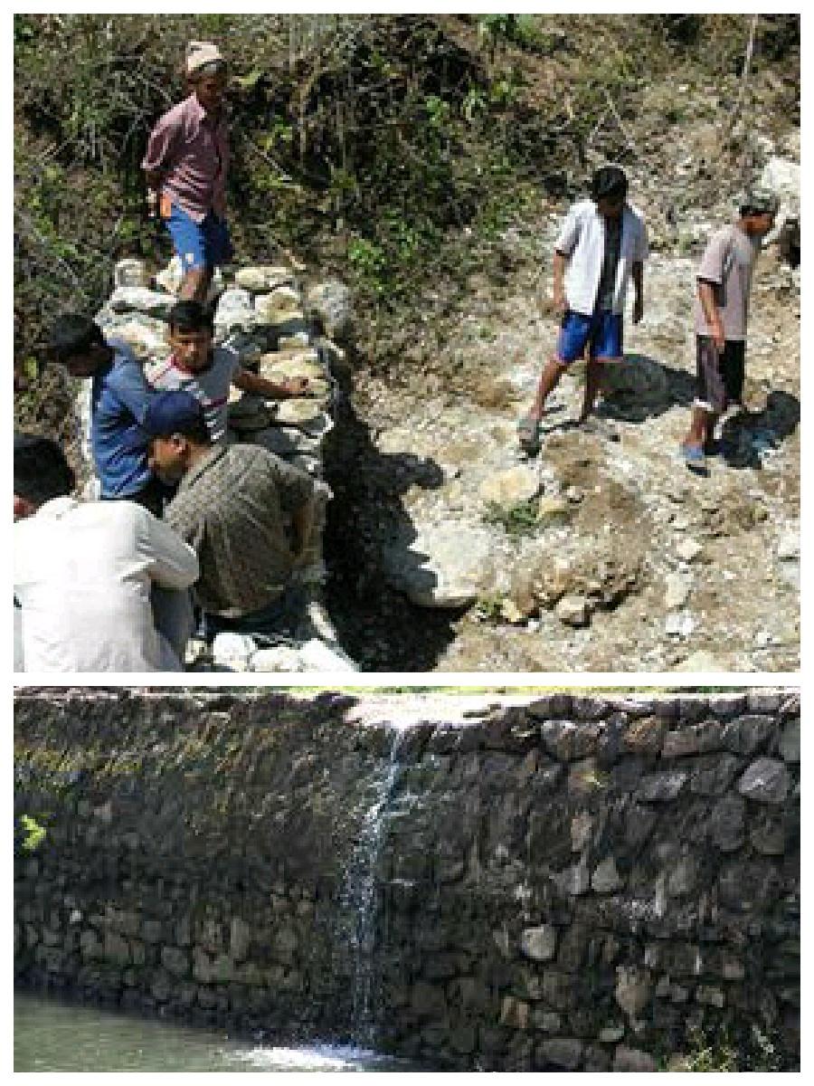
Hilly areas are prone to flash flood that occur with little warning. During rainy season, level of water rises in the stream due to which land mass field of around area was degraded. This technology is used to control the land mass and water flowing from upper region to the lower region of the hill. The natural stream was modified to deep and more sloppy. And surrounding walls were made by piling up stones dams and tighten them by metal wires. These dams decrease the slope gradient and reduce the velocity of water flow and promote the deposition of eroded materials.
Purpose of the Technology: There was no problem of landslide and downstream flood before. But after the road construction, soil became loose resulting in the occurrence of downstream flood. It caused massive destruction of agricultural fields and disturbed settlement areas. Also, stone and gravel during landslide and stream flood used to be deposited and block the flow of the water. So land user invented by this technology to control and reduce the effects of downstream flood.
Establishment / maintenance activities and inputs: Land users and other villagers took the initiative to carry out the technology. Stones were abundantly found in the stream that were utilized to make the dams on lining the stream. Dozer was used to deepen the stream and increase the slope of stream. Stones were piled up and tied by iron wires on the bank of stream by local farmers themselves with their own investment.
Natural / human environment: The area where this technology has been used is a hilly area. Soil fertility in that area is low or medium which differs according to the place. Due to landslide and downstream flood, sand and gravel get deposited in the cropland, so its fertility is very low. No crops can be grown in there. This technology helps to control further degradation of land but could't help to restore natural quality of land.
This area is semi arid area. Due to the proper supply of water the area is prevented from drying. People living in that area are mainly farmers and depend on agriculture for livelihood. Also the area is developing more after the road construction. People are now being more aware about health, education and development.
2.3 รูปภาพของเทคโนโลยี
2.5 ประเทศภูมิภาค หรือสถานที่ตั้งที่เทคโนโลยีได้นำไปใช้และได้รับการครอบคลุมโดยการประเมินนี้
ประเทศ:
เนปาล
ภูมิภาค/รัฐ/จังหวัด:
Nepal
ข้อมูลจำเพาะเพิ่มเติมของสถานที่ตั้ง :
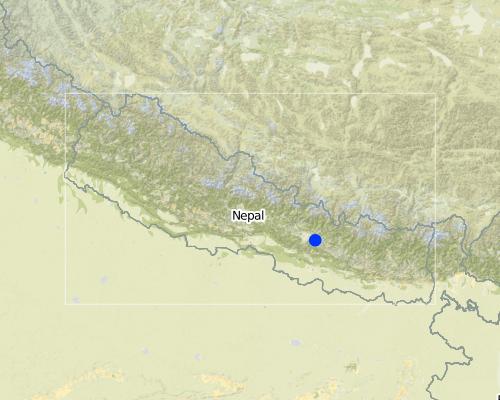
Kavre
Map
×2.6 วันที่การดำเนินการ
ถ้าไม่รู้ปีที่แน่นอน ให้ระบุวันที่โดยประมาณ:
- น้อยกว่า 10 ปี (ไม่นานนี้)
2.7 คำแนะนำของเทคโนโลยี
ให้ระบุว่าเทคโนโลยีถูกแนะนำเข้ามาอย่างไร:
- ด้วยการริเริ่มของผู้ใช้ที่ดินเอง
ความคิดเห็น (ประเภทของโครงการ เป็นต้น) :
The problem of downstream flood was caused before two years after the construction of road. so technology was also developed before 2 years.
3. การจัดประเภทของเทคโนโลยี SLM
3.1 วัตถุประสงค์หลักของเทคโนโลยี
- ลด ป้องกัน ฟื้นฟู การเสื่อมโทรมของที่ดิน
- ลดความเสี่ยงของภัยพิบัติ
3.2 ประเภทของการใช้ที่ดินในปัจจุบันที่ได้นำเทคโนโลยีไปใช้

ทางน้ำ แหล่งน้ำ พื้นที่ชุ่มน้ำ
- Waterway, ditch
แสดงความคิดเห็น:
Major land use problems (compiler’s opinion): Cropland destruction
Major land use problems (land users’ perception): Cropland destruction, vegetation destruction, decreased soil fertility.
Constraints of waterway/ditch (Ditch for the flow of water): Big stone which block the water ways.
3.3 ข้อมูลเพิ่มเติมเกี่ยวกับการใช้ที่ดิน
จำนวนของฤดูเพาะปลูกต่อปี:
- 3
ระบุ:
Longest growing period in days: 150; Longest growing period from month to month: june-november; Second longest growing period in days: 90; Second longest growing period from month to month: march-june
3.4 กลุ่ม SLM ที่ตรงกับเทคโนโลยีนี้
- การจัดการน้ำผิวดิน (น้ำพุ แม่น้ำทะเลสาบ ทะเล)
3.5 กระจายตัวของเทคโนโลยี
ระบุการกระจายตัวของเทคโนโลยี:
- ใช้ ณ จุดที่เฉพาะเจาะจงหรือเน้นไปยังบริเวณพื้นที่ขนาดเล็ก
แสดงความคิดเห็น:
The area occupied by SLM technology is approximately 28 km2. It includes area occupied by conversation measures and the additional area protected by them.
3.6 มาตรการ SLM ที่ประกอบกันเป็นเทคโนโลยี

มาตรการอนุรักษ์ด้วยโครงสร้าง
- S3: Graded ditches, channels, waterways
- S6: กำแพง สิ่งกีดขวาง รั้วไม้ รั้วต่างๆ
3.7 รูปแบบหลักของการเสื่อมโทรมของที่ดินที่ได้รับการแก้ไขโดยเทคโนโลยี

การกัดกร่อนของดินโดยน้ำ
- Wg (Gully erosion): การกัดกร่อนแบบร่องธารหรือการทำให้เกิดร่องน้ำเซาะ
- Wo (Offsite degradation): ผลกระทบนอกพื้นที่
แสดงความคิดเห็น:
Main causes of degradation: urbanisation and infrastructure development (Construction of road i.e infrastructure development), floods (Downstream flood during rainy season.), inputs and infrastructure: (roads, markets, distribution of water points, other, …) (Road construction)
Secondary causes of degradation: Heavy / extreme rainfall (intensity/amounts) (Heavy rainfall during rainy season cause downstream flooding.)
3.8 การป้องกัน การลดลง หรือการฟื้นฟูความเสื่อมโทรมของที่ดิน
ระบุเป้าหมายของเทคโนโลยีกับความเสื่อมโทรมของที่ดิน:
- ป้องกันความเสื่อมโทรมของที่ดิน
แสดงความคิดเห็น:
Secondary goals: mitigation / reduction of land degradation, rehabilitation / reclamation of denuded land
4. ข้อมูลจำเพาะด้านเทคนิค กิจกรรมการนำไปปฏิบัติใช้ ปัจจัยนำเข้า และค่าใช้จ่าย
4.1 แบบแปลนทางเทคนิคของเทคโนโลยี
ผู้เขียน:
Bibhu Gautam, KUGH,Kavre
4.2 ข้อมูลจำเพาะด้านเทคนิคและการอธิบายแบบแปลนทางเทคนิค
This technical drawing shows the constructed dam and gully which allow proper flow of downstream flood.
Location: Chyamrangbes. Kavre
Technical knowledge required for land users: high
Technical knowledge required for labour: high (Through their experience to construct in a useful way.)
Main technical functions: control of concentrated runoff: drain / divert, reduction of slope angle
Secondary technical functions: control of dispersed runoff: retain / trap, improvement of surface structure (crusting, sealing)
Diversion ditch/ drainage
Vertical interval between structures (m): n'a
Spacing between structures (m): n'a
Depth of ditches/pits/dams (m): 2.13
Width of ditches/pits/dams (m): 3.2
Length of ditches/pits/dams (m): 1000
Height of bunds/banks/others (m): 1.6
Width of bunds/banks/others (m): 0.8
Length of bunds/banks/others (m): 1000
Construction material (earth): Soil excavate from the ditches is used to build bank.
Construction material (stone): the cut off ditch is lined with stones, embankment with stones.
Construction material (other): iron wire was used to bind the stone together.
Slope (which determines the spacing indicated above): 12%
4.3 ข้อมูลทั่วไปเกี่ยวกับการคำนวณปัจจัยนำเข้าและค่าใช้จ่าย
ระบุสกุลเงินที่ใช้คำนวณค่าใช้จ่าย:
- ดอลลาร์สหรัฐ
4.4 กิจกรรมเพื่อการจัดตั้ง
| กิจกรรม | ประเภทของมาตรการ | ช่วงเวลาดำเนินการ | |
|---|---|---|---|
| 1. | Land user increased the width and slope of existing ditch for easy flow of water. | ด้วยโครงสร้าง | dry seasonm |
| 2. | Land user embanked the bank with stones on either side. | ด้วยโครงสร้าง | dry season |
| 3. | Stones are bind together by wires in some places. | ด้วยโครงสร้าง | dry season |
4.5 ค่าใช้จ่ายของปัจจัยนำเข้าที่จำเป็นสำหรับการจัดตั้ง
| ปัจจัยนำเข้า | หน่วย | ปริมาณ | ค่าใช้จ่ายต่อหน่วย | ค่าใช้จ่ายทั้งหมดต่อปัจจัยนำเข้า | %ของค่าใช้จ่ายที่ก่อให้เกิดขึ้นโดยผู้ใช้ที่ดิน | |
|---|---|---|---|---|---|---|
| แรงงาน | Increase the width and slope of ditch | ha | 1.0 | 941.17 | 941.17 | 100.0 |
| ค่าใช้จ่ายทั้งหมดของการจัดตั้งเทคโนโลยี | 941.17 | |||||
แสดงความคิดเห็น:
Duration of establishment phase: 2 month(s)
4.7 ค่าใช้จ่ายของปัจจัยนำเข้าและกิจกรรมที่เกิดขึ้นเป็นประจำที่ต้องการการบำรุงรักษา (ต่อปี)
แสดงความคิดเห็น:
Machinery/ tools: dozer, Dozer
The above mentioned cost is not given per unit/hectar. It is the total cost used for that technology.
4.8 ปัจจัยสำคัญที่สุดที่มีผลกระทบต่อค่าใช้จ่าย
ปัจจัยสำคัญที่สุดที่มีผลกระทบต่อค่าใช้จ่ายต่างๆ:
The most determinate factor affecting the cost is land structure. Land contains loamy soil which made it difficult for construction of ditch.
5. สิ่งแวดล้อมทางธรรมชาติและของมนุษย์
5.1 ภูมิอากาศ
ฝนประจำปี
- < 250 ม.ม.
- 251-500 ม.ม.
- 501-750 ม.ม.
- 751-1,000 ม.ม.
- 1,001-1,500 ม.ม.
- 1,501-2,000 ม.ม.
- 2,001-3,000 ม.ม.
- 3,001-4,000 ม.ม.
- > 4,000 ม.ม.
ข้อมูลจำเพาะ/ความคิดเห็นเรื่องปริมาณน้ำฝน:
monsoon rain, dry winter
เขตภูมิอากาศเกษตร
- กึ่งแห้งแล้ง
Thermal climate class: subtropics
5.2 สภาพภูมิประเทศ
ค่าเฉลี่ยความลาดชัน:
- ราบเรียบ (0-2%)
- ลาดที่ไม่ชัน (3-5%)
- ปานกลาง (6-10%)
- เป็นลูกคลื่น (11-15%)
- เป็นเนิน (16-30%)
- ชัน (31-60%)
- ชันมาก (>60%)
ธรณีสัณฐาน:
- ที่ราบสูง/ที่ราบ
- สันเขา
- ไหล่เขา
- ไหล่เนินเขา
- ตีนเนิน
- หุบเขา
ระดับความสูง:
- 0-100 เมตร
- 101-500 เมตร
- 501-1,000 เมตร
- 1,001-1,500 เมตร
- 1,501-2,000 เมตร
- 2,001-2,500 เมตร
- 2,501-3,000 เมตร
- 3,001-4,000 เมตร
- > 4,000 เมตร
ให้ระบุถ้าเทคโนโลยีได้ถูกนำไปใช้:
- บริเวณแอ่งบนที่ราบ (concave situations)
ความคิดเห็นและข้อมูลจำเพาะเพิ่มเติมเรื่องสภาพภูมิประเทศ:
Slopes on average: The average slope is about 15%.
5.3 ดิน
ค่าเฉลี่ยความลึกของดิน:
- ตื้นมาก (0-20 ซ.ม.)
- ตื้น (21-50 ซ.ม.)
- ลึกปานกลาง (51-80 ซ.ม.)
- ลึก (81-120 ซ.ม.)
- ลึกมาก (>120 ซ.ม.)
เนื้อดิน (ดินชั้นบน):
- หยาบ/เบา (ดินทราย)
อินทรียวัตถุในดิน:
- ต่ำ (<1%)
(ถ้ามี) ให้แนบคำอธิบายเรื่องดินแบบเต็มหรือระบุข้อมูลที่มีอยู่ เช่น ชนิดของดิน ค่า pH ของดินหรือความเป็นกรดของดิน ความสามารถในการแลกเปลี่ยนประจุบวก ไนโตรเจน ความเค็ม เป็นต้น:
Soil texture: Sandy and graveled land
Soil fertility is medium - low and varies according to soil texture
Soil drainage / infiltration is poor
Soil water storage capacity is low, soil is sandy and contains gravel. So it cannot store water
5.4 ความเป็นประโยชน์และคุณภาพของน้ำ
ระดับน้ำใต้ดิน:
ที่ผิวดิน
น้ำไหลบ่าที่ผิวดิน:
เกินพอ
คุณภาพน้ำ (ที่ยังไม่ได้บำบัด):
ใช้ประโยชน์ไม่ได้
ความคิดเห็นและข้อมูลจำเพาะเพิ่มเติมเรื่องคุณภาพและปริมาณน้ำ:
Ground water table: Infiltration is very low. Water only flow on surface.
Availability of surface water: During rainy season excess water flow through the steam.
Water quality (untreated): Some portion water is used in agriculture
5.5 ความหลากหลายทางชีวภาพ
ความหลากหลายทางชนิดพันธุ์:
- ต่ำ
ความคิดเห็นและข้อมูลจำเพาะเพิ่มเติมของความหลากหลายทางชีวภาพ:
Soil is very infertile. So it is poor in biodiversity.
5.6 ลักษณะของผู้ใช้ที่ดินที่นำเทคโนโลยีไปปฏิบัติใช้
รายได้ที่มาจากนอกฟาร์ม:
- < 10% ของรายได้ทั้งหมด
ระดับของความมั่งคั่งโดยเปรียบเทียบ:
- พอมีพอกิน
- รวย
เป็นรายบุคคล/ครัวเรือน:
- กลุ่ม/ชุมชน
เพศ:
- หญิง
- ชาย
ระบุลักษณะอื่นๆที่เกี่ยวข้องของผู้ใช้ที่ดิน:
Land users applying the Technology are mainly common / average land users
Difference in the involvement of women and men: More male because women cannot do such type of heavy labor work.
Population density: 50-100 persons/km2
Annual population growth: 2% - 3%
(living standard is more than average).
(average life standard).
Off-farm income specification: Their land is protected from further degradation
5.7 พื้นที่เฉลี่ยของที่ดินที่เป็นเจ้าของหรือเช่าโดยผู้ใช้ที่ดินที่นำเทคโนโลยีไปปฏิบัติใช้
- < 0.5 เฮกตาร์
- 0.5-1 เฮกตาร์
- 1-2 เฮกตาร์
- 2-5 เฮกตาร์
- 5-15 เฮกตาร์
- 15-50 เฮกตาร์
- 50-100 เฮกตาร์
- 100-500 เฮกตาร์
- 500-1,000 เฮกตาร์
- 1,000-10,000 เฮกตาร์
- >10,000 เฮกตาร์
พิจารณาว่าเป็นขนาดเล็ก กลาง หรือขนาดใหญ่ (ซึ่งอ้างอิงถึงบริบทระดับท้องถิ่น):
- ขนาดเล็ก
5.8 กรรมสิทธิ์ในที่ดิน สิทธิในการใช้ที่ดินและสิทธิในการใช้น้ำ
กรรมสิทธิ์ในที่ดิน:
- รายบุคคล ไม่ได้รับสิทธิครอบครอง
สิทธิในการใช้ที่ดิน:
- เกี่ยวกับชุมชน (ถูกจัดระเบียบ)
แสดงความคิดเห็น:
The land where SLM technology is applied belongs to individual, but it land use right belongs to community.
5.9 การเข้าถึงบริการและโครงสร้างพื้นฐาน
สุขภาพ:
- จน
- ปานกลาง
- ดี
การศึกษา:
- จน
- ปานกลาง
- ดี
ความช่วยเหลือทางด้านเทคนิค:
- จน
- ปานกลาง
- ดี
การจ้างงาน (เช่น ภายนอกฟาร์ม):
- จน
- ปานกลาง
- ดี
ตลาด:
- จน
- ปานกลาง
- ดี
พลังงาน:
- จน
- ปานกลาง
- ดี
ถนนและการขนส่ง:
- จน
- ปานกลาง
- ดี
น้ำดื่มและการสุขาภิบาล:
- จน
- ปานกลาง
- ดี
บริการด้านการเงิน:
- จน
- ปานกลาง
- ดี
6. ผลกระทบและสรุปคำบอกกล่าว
6.1 ผลกระทบในพื้นที่ดำเนินการ (On-site) จากการใช้เทคโนโลยี
ผลกระทบทางด้านเศรษฐกิจและสังคม
การผลิต
การเสี่ยงต่อความล้มเหลวในการผลิต
จำนวนก่อน SLM:
n/a
หลังจาก SLM:
n/a
แสดงความคิดเห็น/ระบุ:
protected the cropland from flood
ผลกระทบด้านสังคมวัฒนธรรมอื่น ๆ
SLM หรือความรู้เรื่องความเสื่อมโทรมของที่ดิน
จำนวนก่อน SLM:
n/a
หลังจาก SLM:
n/a
แสดงความคิดเห็น/ระบุ:
active participating people on land conservation.
ผลกระทบด้านนิเวศวิทยา
วัฐจักรน้ำหรือน้ำบ่า
น้ำไหลบ่าที่ผิวดิน
แสดงความคิดเห็น/ระบุ:
water travel in fixed path
การระบายน้ำส่วนเกิน
แสดงความคิดเห็น/ระบุ:
improved water way for passage of excess water
ดิน
การสูญเสียดิน
แสดงความคิดเห็น/ระบุ:
soil loss due to flooding is reduced
6.2 ผลกระทบนอกพื้นที่ดำเนินการ (Off-site) จากการใช้เทคโนโลยี
น้ำท่วมพื้นที่ท้ายน้ำ
แสดงความคิดเห็น/ระบุ:
the main benefits of this technology
6.3 การเผชิญและความตอบสนองของเทคโนโลยีต่อการเปลี่ยนแปลงสภาพภูมิอากาศที่ค่อยเป็นค่อยไป และสภาพรุนแรงของภูมิอากาศ / ภัยพิบัติ (ที่รับรู้ได้โดยผู้ใช้ที่ดิน)
การเปลี่ยนแปลงสภาพภูมิอากาศที่ค่อยเป็นค่อยไป
การเปลี่ยนแปลงสภาพภูมิอากาศที่ค่อยเป็นค่อยไป
| ฤดู | ประเภทของการเปลี่ยนแปลงสภาพภูมิอากาศที่ค่อยเป็นค่อยไป และสภาพรุนแรงของภูมิอากาศ | เทคโนโลยีมีวิธีการรับมืออย่างไร | |
|---|---|---|---|
| อุณหภูมิประจำปี | เพิ่มขึ้น | ดี |
สภาพรุนแรงของภูมิอากาศ (ภัยพิบัติ)
ภัยพิบัติทางอุตุนิยมวิทยา
| เทคโนโลยีมีวิธีการรับมืออย่างไร | |
|---|---|
| พายุฝนประจำท้องถิ่น | ไม่ค่อยดี |
| พายุลมประจำท้องถิ่น | ไม่ทราบ |
ภัยพิบัติจากสภาพภูมิอากาศ
| เทคโนโลยีมีวิธีการรับมืออย่างไร | |
|---|---|
| ภัยจากฝนแล้ง | ดี |
ภัยพิบัติจากน้ำ
| เทคโนโลยีมีวิธีการรับมืออย่างไร | |
|---|---|
| น้ำท่วมตามปกติ (แม่น้ำ) | ไม่ค่อยดี |
แสดงความคิดเห็น:
Dame can be made more tolerant again flash flood by using wire to tighten the stone walls or making the concrete wall.
6.4 การวิเคราะห์ค่าใช้จ่ายและผลประโยชน์ที่ได้รับ
ผลประโยชน์ที่ได้รับเปรียบเทียบกับค่าใช้จ่ายในการจัดตั้งเป็นอย่างไร (จากมุมมองของผู้ใช้ที่ดิน)
ผลตอบแทนระยะสั้น:
ด้านลบ
ผลตอบแทนระยะยาว:
ด้านลบเล็กน้อย
แสดงความคิดเห็น:
This technology is not a investment purpose. People used their own money to construct it.
6.5 การปรับตัวของเทคโนโลยี
- ครั้งเดียวหรือเป็นการทดลอง
ถ้ามีข้อมูลให้บอกปริมาณด้วย (จำนวนของครัวเรือนหรือครอบคลุมพื้นที่):
14 households in an area of 10 - 100 sq km (50 - 100 persons per sq km)
จากทั้งหมดที่ได้รับเทคโนโลยีเข้ามามีจำนวนเท่าใดที่ทำแบบทันที โดยไม่ได้รับการจูงใจด้านวัสดุหรือการเงินใด ๆ:
- 0-10%
แสดงความคิดเห็น:
100% of land user families have adopted the Technology with external material support
14 land user families have adopted the Technology with external material support
Comments on acceptance with external material support: Iron wire was provided by Bagmati watershed.
There is a strong trend towards spontaneous adoption of the Technology
Comments on adoption trend: People have well accepted this technology.
6.7 จุดแข็ง / ข้อได้เปรียบ / โอกาสของเทคโนโลยี
| จุดแข็ง / ข้อได้เปรียบ / โอกาสในทัศนคติของผู้ใช้ที่ดิน |
|---|
|
Risk of downstream flood and landslide is reduced. How can they be sustained / enhanced? If they had been more donation from government or any other projects, they would construct concrete or more flood resistance dams. As some parts are still unconstructed they would complete them with some more external support. |
| Agriculture land get protected so they can plant the crop without being at risk. |
| จุดแข็ง / ข้อได้เปรียบ / โอกาสในทัศนคติของผู้รวบรวมหรือวิทยากรหลัก |
|---|
|
Proper water drainage system and water can get collected in the river following the fix path. How can they be sustained / enhanced? Fodder plant could be grown on the stream banks which is now left and unused. This could be used to feed the animals and would also help to control flood and landslide. |
|
It reduced the risk of further land degradation by downstream flood. How can they be sustained / enhanced? Dams can be made more strong by making concrete walls |
6.8 จุดอ่อน / ข้อเสียเปรียบ / ความเสี่ยงของเทคโนโลยีและวิธีการแก้ไข
| จุดอ่อน / ข้อเสียเปรียบ / ความเสี่ยงในทัศนคติของผู้ใช้ที่ดิน | มีวิธีการแก้ไขได้อย่างไร |
|---|---|
| N/A |
| จุดอ่อน / ข้อเสียเปรียบ / ความเสี่ยงในทัศนคติของผู้รวบรวมหรือวิทยากรหลัก | มีวิธีการแก้ไขได้อย่างไร |
|---|---|
| N/A | N/A |
ลิงก์และโมดูล
ขยายทั้งหมด ย่อทั้งหมดลิงก์
ไม่มีลิงก์
โมดูล
ไม่มีโมดูล


