Water retention basin, a flood-control reservoir [สโลวาเกีย]
- ผู้สร้างสรรค์:
- การอัพเดท:
- ผู้รวบรวม: Zuzana Studvova
- ผู้เรียบเรียง: –
- ผู้ตรวจสอบ: Fabian Ottiger
Polder (Slovak language)
technologies_1675 - สโลวาเกีย
ดูส่วนย่อย
ขยายทั้งหมด ย่อทั้งหมด1. ข้อมูลทั่วไป
1.2 รายละเอียดที่ติดต่อได้ของผู้รวบรวมและองค์กรที่เกี่ยวข้องในการประเมินและการจัดเตรียมทำเอกสารของเทคโนโลยี
ชื่อของโครงการซึ่งอำนวยความสะดวกในการทำเอกสารหรือการประเมินเทคโนโลยี (ถ้าเกี่ยวข้อง)
Preventing and Remediating degradation of soils in Europe through Land Care (EU-RECARE )ชื่อขององค์กรซึ่งอำนวยความสะดวกในการทำเอกสารหรือการประเมินเทคโนโลยี (ถ้าเกี่ยวข้อง)
Slovak University of Technology (Slovak University of Technology) - สโลวาเกีย1.3 เงื่อนไขการใช้ข้อมูลที่ได้บันทึกผ่านทาง WOCAT
ผู้รวบรวมและวิทยากรหลักยอมรับเงื่อนไขเกี่ยวกับการใช้ข้อมูลที่ถูกบันทึกผ่านทาง WOCAT:
ใช่
2. การอธิบายลักษณะของเทคโนโลยี SLM
2.1 การอธิบายแบบสั้น ๆ ของเทคโนโลยี
คำจำกัดความของเทคโนโลยี:
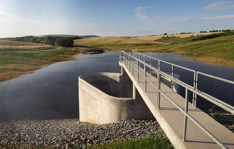
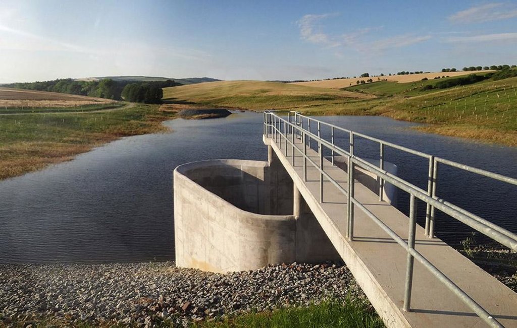
Flood-Control Reservoir - a complex hydraulic facility
2.2 การอธิบายแบบละเอียดของเทคโนโลยี
คำอธิบาย:
The construction is designed to prevent the flooding of the territory located behind the structure, to eliminate the threat of floods caused by storm rainfall and inappropriate farming, and to reduce flow fluctuation.
Purpose of the Technology: The Svacenický creek polder was built to transform Q100 flood waves.
Natural / human environment: The Svacenický creek polder is part of the flood protection of the area, which is located in the west of Slovakia in the cadastral area of the town of Myjava, in the locality of Tura Luka. The town of Myjava has been plagued by frequent floods in recent years, which have resulted in significant material damage, thereby severely hampering the quality of the local residents´ lives.
2.3 รูปภาพของเทคโนโลยี
2.5 ประเทศภูมิภาค หรือสถานที่ตั้งที่เทคโนโลยีได้นำไปใช้และได้รับการครอบคลุมโดยการประเมินนี้
ประเทศ:
สโลวาเกีย
ภูมิภาค/รัฐ/จังหวัด:
Slovakia / Trenčiansky region
ข้อมูลจำเพาะเพิ่มเติมของสถานที่ตั้ง :
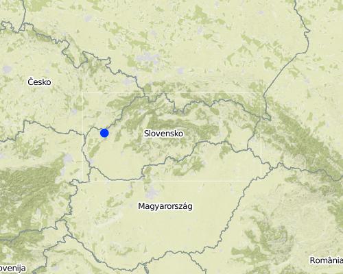
Myjava / Turá Lúka
Map
×2.6 วันที่การดำเนินการ
ถ้าไม่รู้ปีที่แน่นอน ให้ระบุวันที่โดยประมาณ:
- 10-50 ปี
2.7 คำแนะนำของเทคโนโลยี
ให้ระบุว่าเทคโนโลยีถูกแนะนำเข้ามาอย่างไร:
- ทางโครงการหรือจากภายนอก
3. การจัดประเภทของเทคโนโลยี SLM
3.2 ประเภทของการใช้ที่ดินในปัจจุบันที่ได้นำเทคโนโลยีไปใช้

พื้นที่ปลูกพืช
- การปลูกพืชล้มลุกอายุปีเดียว
แสดงความคิดเห็น:
Major land use problems (compiler’s opinion): Generation of gulllies.
Major land use problems (land users’ perception): Generation of gulllies and landslides.
Future (final) land use (after implementation of SLM Technology): Other: Ow: Waterways, drainage lines, ponds, dams
ถ้าการใช้ที่ดินมีการเปลี่ยนแปลงเนื่องมาจากการนำเทคโนโลยีไปปฏิบัติใช้ ให้ระบุการใช้ที่ดินก่อนนำเทคโนโลยีไปปฏิบัติใช้:
Cropland: Ca: Annual cropping
3.3 ข้อมูลเพิ่มเติมเกี่ยวกับการใช้ที่ดิน
การใช้น้ำของที่ดินที่มีการใช้เทคโนโลยีอยู่:
- น้ำฝนร่วมกับการชลประทาน
จำนวนของฤดูเพาะปลูกต่อปี:
- 1
ระบุ:
Longest growing period in days: 180Longest growing period from month to month: April to September
3.4 กลุ่ม SLM ที่ตรงกับเทคโนโลยีนี้
- การจัดการน้ำผิวดิน (น้ำพุ แม่น้ำทะเลสาบ ทะเล)
3.5 กระจายตัวของเทคโนโลยี
ระบุการกระจายตัวของเทคโนโลยี:
- กระจายไปอย่างสม่ำเสมอในพื้นที่
ถ้าหากว่าเทคโนโลยีได้มีการกระจายออกไปอย่างสม่ำเสมอในพื้นที่ ให้ระบุปริมาณพื้นที่ที่ได้รับการครอบคลุมถึง:
- < 0.1 ตร.กม.(10 เฮกตาร์)
แสดงความคิดเห็น:
The reservoir is situated at the Svacenický Creek.
3.6 มาตรการ SLM ที่ประกอบกันเป็นเทคโนโลยี

มาตรการอนุรักษ์ด้วยวิธีพืช
- V1: ต้นไม้และพุ่มไม้คลุมดิน
- V2: หญ้าและไม้ยืนต้น

มาตรการอนุรักษ์ด้วยโครงสร้าง
- S5: เขื่อน ชั้นดินที่แน่นแข็งบ่อน้ำ
แสดงความคิดเห็น:
Main measures: structural measures
Secondary measures: vegetative measures
Type of vegetative measures: scattered / dispersed
3.7 รูปแบบหลักของการเสื่อมโทรมของที่ดินที่ได้รับการแก้ไขโดยเทคโนโลยี

การกัดกร่อนของดินโดยน้ำ
- Wg (Gully erosion): การกัดกร่อนแบบร่องธารหรือการทำให้เกิดร่องน้ำเซาะ
- Wm (Mass movement): การเคลื่อนตัวของมวลดินหรือดินถล่ม
แสดงความคิดเห็น:
Main type of degradation addressed: Wm: mass movements / landslides
Secondary types of degradation addressed: Wg: gully erosion / gullying
Main causes of degradation: Heavy / extreme rainfall (intensity/amounts), floods
Secondary causes of degradation: soil management, crop management (annual, perennial, tree/shrub)
3.8 การป้องกัน การลดลง หรือการฟื้นฟูความเสื่อมโทรมของที่ดิน
ระบุเป้าหมายของเทคโนโลยีกับความเสื่อมโทรมของที่ดิน:
- ป้องกันความเสื่อมโทรมของที่ดิน
แสดงความคิดเห็น:
Main goals: prevention of land degradation
4. ข้อมูลจำเพาะด้านเทคนิค กิจกรรมการนำไปปฏิบัติใช้ ปัจจัยนำเข้า และค่าใช้จ่าย
4.1 แบบแปลนทางเทคนิคของเทคโนโลยี
4.2 ข้อมูลจำเพาะด้านเทคนิคและการอธิบายแบบแปลนทางเทคนิค
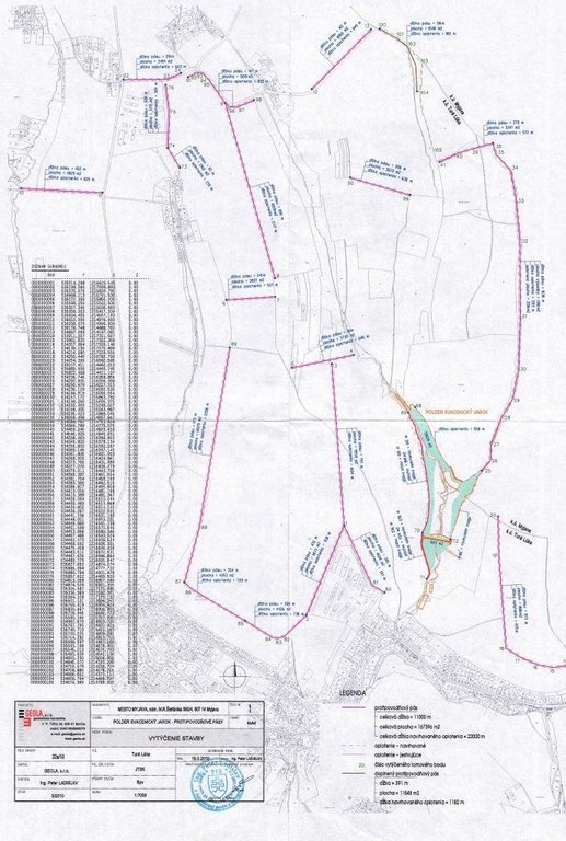
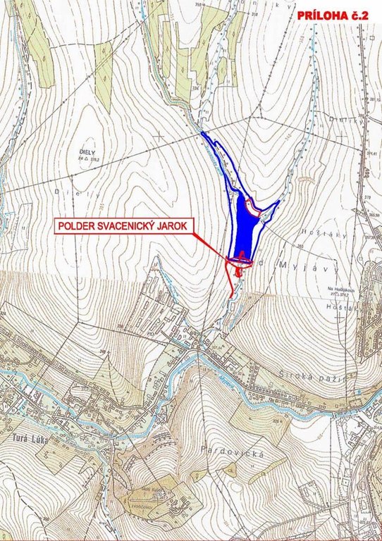
This technical drawing shows where the reservoir is localized. Blue colour presents the reservoir, red represents a complex hydraulic facility that is situated by the polder.
Location: The town of Myjava - the locality of Turá Lúka. Slovakia
Technical knowledge required for field staff / advisors: low
Technical knowledge required for land users: low
Technical knowledge required for Design and construction engineers: high (The preparatory and design documentation is needed.)
Main technical functions: control of concentrated runoff: retain / trap
Secondary technical functions: stabilisation of soil (eg by tree roots against land slides)
Aligned: -linear
Vegetative material: G : grass
Scattered / dispersed
Vegetative material: T : trees / shrubs, F : fruit trees / shrubs
Trees/ shrubs species: together 50 000 plants
Specification of dams/ pans/ ponds: Capacity 215,800m3
Catchment area: 6 km2m2
Beneficial area: 3 ham2
Slope of dam wall inside: -%;
Slope of dam wall outside: -%
Dimensions of spillways: -m
Other specifications: -
Vegetation is used for stabilisation of structures.
4.3 ข้อมูลทั่วไปเกี่ยวกับการคำนวณปัจจัยนำเข้าและค่าใช้จ่าย
อื่นๆ หรือสกุลเงินประจำชาติ (ระบุ):
euro
ระบุอัตราแลกเปลี่ยนจากดอลลาร์สหรัฐเป็นสกุลเงินท้องถิ่น (ถ้าเกี่ยวข้อง) คือ 1 เหรียญสหรัฐ =:
0.91
4.7 ค่าใช้จ่ายของปัจจัยนำเข้าและกิจกรรมที่เกิดขึ้นเป็นประจำที่ต้องการการบำรุงรักษา (ต่อปี)
แสดงความคิดเห็น:
The list of main activities:1/Land purchase (144849.574 USD),2/ Preparatory and design documentation (49305.338 USD), 3/Construction works (2345530.958 USD), 4/Constuction supervision (40135.48 USD), 5/Supporting activities (dissemination 494.55 USD, project management 40098.993 USD).
4.8 ปัจจัยสำคัญที่สุดที่มีผลกระทบต่อค่าใช้จ่าย
ปัจจัยสำคัญที่สุดที่มีผลกระทบต่อค่าใช้จ่ายต่างๆ:
The most determinate factors that affect the costs are realization works and material used, and repurchase of land.
5. สิ่งแวดล้อมทางธรรมชาติและของมนุษย์
5.1 ภูมิอากาศ
ฝนประจำปี
- < 250 ม.ม.
- 251-500 ม.ม.
- 501-750 ม.ม.
- 751-1,000 ม.ม.
- 1,001-1,500 ม.ม.
- 1,501-2,000 ม.ม.
- 2,001-3,000 ม.ม.
- 3,001-4,000 ม.ม.
- > 4,000 ม.ม.
เขตภูมิอากาศเกษตร
- กึ่งชุ่มชื้น
Thermal climate class: temperate
5.2 สภาพภูมิประเทศ
ค่าเฉลี่ยความลาดชัน:
- ราบเรียบ (0-2%)
- ลาดที่ไม่ชัน (3-5%)
- ปานกลาง (6-10%)
- เป็นลูกคลื่น (11-15%)
- เป็นเนิน (16-30%)
- ชัน (31-60%)
- ชันมาก (>60%)
ธรณีสัณฐาน:
- ที่ราบสูง/ที่ราบ
- สันเขา
- ไหล่เขา
- ไหล่เนินเขา
- ตีนเนิน
- หุบเขา
ระดับความสูง:
- 0-100 เมตร
- 101-500 เมตร
- 501-1,000 เมตร
- 1,001-1,500 เมตร
- 1,501-2,000 เมตร
- 2,001-2,500 เมตร
- 2,501-3,000 เมตร
- 3,001-4,000 เมตร
- > 4,000 เมตร
ความคิดเห็นและข้อมูลจำเพาะเพิ่มเติมเรื่องสภาพภูมิประเทศ:
Altitudinal zone: 101-500 m a.s.l. (370-400 m a.s.l.)
5.3 ดิน
ค่าเฉลี่ยความลึกของดิน:
- ตื้นมาก (0-20 ซ.ม.)
- ตื้น (21-50 ซ.ม.)
- ลึกปานกลาง (51-80 ซ.ม.)
- ลึก (81-120 ซ.ม.)
- ลึกมาก (>120 ซ.ม.)
เนื้อดิน (ดินชั้นบน):
- ปานกลาง (ดินร่วน ทรายแป้ง)
- ละเอียด/หนัก (ดินเหนียว)
5.4 ความเป็นประโยชน์และคุณภาพของน้ำ
คุณภาพน้ำ (ที่ยังไม่ได้บำบัด):
เป็นน้ำเพื่อการดื่มที่ดี
5.6 ลักษณะของผู้ใช้ที่ดินที่นำเทคโนโลยีไปปฏิบัติใช้
ระดับของความมั่งคั่งโดยเปรียบเทียบ:
- พอมีพอกิน
ระดับของการใช้เครื่องจักรกล:
- การใช้เครื่องจักรหรือเครื่องยนต์
ระบุลักษณะอื่นๆที่เกี่ยวข้องของผู้ใช้ที่ดิน:
Population density: 50-100 persons/km2
Market orientation of production system: subsistence (self-supply), mixed (subsistence/ commercial, commercial/ market
5.7 พื้นที่เฉลี่ยของที่ดินที่เป็นเจ้าของหรือเช่าโดยผู้ใช้ที่ดินที่นำเทคโนโลยีไปปฏิบัติใช้
- < 0.5 เฮกตาร์
- 0.5-1 เฮกตาร์
- 1-2 เฮกตาร์
- 2-5 เฮกตาร์
- 5-15 เฮกตาร์
- 15-50 เฮกตาร์
- 50-100 เฮกตาร์
- 100-500 เฮกตาร์
- 500-1,000 เฮกตาร์
- 1,000-10,000 เฮกตาร์
- >10,000 เฮกตาร์
แสดงความคิดเห็น:
Average area of land owned or leased by land users applying the Technology: Also 1-2 ha
5.8 กรรมสิทธิ์ในที่ดิน สิทธิในการใช้ที่ดินและสิทธิในการใช้น้ำ
สิทธิในการใช้ที่ดิน:
- เกี่ยวกับชุมชน (ถูกจัดระเบียบ)
แสดงความคิดเห็น:
Land ownership: state, communal / village, individual, not titled
5.9 การเข้าถึงบริการและโครงสร้างพื้นฐาน
สุขภาพ:
- จน
- ปานกลาง
- ดี
การศึกษา:
- จน
- ปานกลาง
- ดี
ความช่วยเหลือทางด้านเทคนิค:
- จน
- ปานกลาง
- ดี
การจ้างงาน (เช่น ภายนอกฟาร์ม):
- จน
- ปานกลาง
- ดี
ตลาด:
- จน
- ปานกลาง
- ดี
พลังงาน:
- จน
- ปานกลาง
- ดี
ถนนและการขนส่ง:
- จน
- ปานกลาง
- ดี
น้ำดื่มและการสุขาภิบาล:
- จน
- ปานกลาง
- ดี
บริการด้านการเงิน:
- จน
- ปานกลาง
- ดี
6. ผลกระทบและสรุปคำบอกกล่าว
6.1 ผลกระทบในพื้นที่ดำเนินการ (On-site) จากการใช้เทคโนโลยี
ผลกระทบด้านสังคมวัฒนธรรมอื่น ๆ
Improved livelihoods and human well-being
แสดงความคิดเห็น/ระบุ:
The technology had a positive impact on the natural monument river Myjava. These are: - Reduction of catastrophic floods in the Tura Luka profile approx. 10% - Minimum flows also increased water runoff approx. 10%
ผลกระทบด้านนิเวศวิทยา
ความหลากหลายทางชีวภาพของพืชและสัตว์
ความหลากหลายของสัตว์
แสดงความคิดเห็น/ระบุ:
Destruction of the use of certain habitats
ผลกระทบด้านนิเวศวิทยาอื่น ๆ
Risk towards adverse events
แสดงความคิดเห็น/ระบุ:
Reduced risk of flooding and thereby material damage.
Flood discharge in the Myjava river
แสดงความคิดเห็น/ระบุ:
10 % decrease of flood discharge
Flood discharge in the Svacenický creelk
New possibilities
แสดงความคิดเห็น/ระบุ:
New water reservoir
New habitats
Removal of riparian vegetation
แสดงความคิดเห็น/ระบุ:
Temporary
6.2 ผลกระทบนอกพื้นที่ดำเนินการ (Off-site) จากการใช้เทคโนโลยี
การไหลของน้ำคงที่และสม่ำเสมอในช่วงฤดูแล้ง
น้ำท่วมพื้นที่ท้ายน้ำ
ความเสียหายต่อโครงสร้างพื้นฐานของรัฐหรือของเอกชน
6.3 การเผชิญและความตอบสนองของเทคโนโลยีต่อการเปลี่ยนแปลงสภาพภูมิอากาศที่ค่อยเป็นค่อยไป และสภาพรุนแรงของภูมิอากาศ / ภัยพิบัติ (ที่รับรู้ได้โดยผู้ใช้ที่ดิน)
การเปลี่ยนแปลงสภาพภูมิอากาศที่ค่อยเป็นค่อยไป
การเปลี่ยนแปลงสภาพภูมิอากาศที่ค่อยเป็นค่อยไป
| ฤดู | ประเภทของการเปลี่ยนแปลงสภาพภูมิอากาศที่ค่อยเป็นค่อยไป และสภาพรุนแรงของภูมิอากาศ | เทคโนโลยีมีวิธีการรับมืออย่างไร | |
|---|---|---|---|
| อุณหภูมิประจำปี | เพิ่มขึ้น | ดี |
สภาพรุนแรงของภูมิอากาศ (ภัยพิบัติ)
ภัยพิบัติทางอุตุนิยมวิทยา
| เทคโนโลยีมีวิธีการรับมืออย่างไร | |
|---|---|
| พายุฝนประจำท้องถิ่น | ดี |
| พายุลมประจำท้องถิ่น | ไม่ทราบ |
ภัยพิบัติจากสภาพภูมิอากาศ
| เทคโนโลยีมีวิธีการรับมืออย่างไร | |
|---|---|
| ภัยจากฝนแล้ง | ดี |
ภัยพิบัติจากน้ำ
| เทคโนโลยีมีวิธีการรับมืออย่างไร | |
|---|---|
| น้ำท่วมตามปกติ (แม่น้ำ) | ดี |
ผลลัพธ์ตามมาที่เกี่ยวข้องกับภูมิอากาศอื่น ๆ
ผลลัพธ์ตามมาที่เกี่ยวข้องกับภูมิอากาศอื่น ๆ
| เทคโนโลยีมีวิธีการรับมืออย่างไร | |
|---|---|
| ช่วงการปลูกพืชที่ลดลงมา | ดี |
6.4 การวิเคราะห์ค่าใช้จ่ายและผลประโยชน์ที่ได้รับ
แสดงความคิดเห็น:
No information about maintenance costs was given.
6.7 จุดแข็ง / ข้อได้เปรียบ / โอกาสของเทคโนโลยี
| จุดแข็ง / ข้อได้เปรียบ / โอกาสในทัศนคติของผู้รวบรวมหรือวิทยากรหลัก |
|---|
| reduction of catastrophic floods in the Tura Luka profile by approx. 10% |
| change in the landscape´s structure, provides a new landscape element – a water area and newly constructed accompanying greenery |
| Minimum flows increased by approx. 10% |
| The construction of the polder will bring about new and improved conditions for other organisms, as it will create new habitats. |
6.8 จุดอ่อน / ข้อเสียเปรียบ / ความเสี่ยงของเทคโนโลยีและวิธีการแก้ไข
| จุดอ่อน / ข้อเสียเปรียบ / ความเสี่ยงในทัศนคติของผู้รวบรวมหรือวิทยากรหลัก | มีวิธีการแก้ไขได้อย่างไร |
|---|---|
| During the construction and operations arable land will not be usable. | |
| Construction of the polder will create a new water area, but in terms of the technical design, the construction will not affect the water table in the greater area. | |
| The effects on the air quality during the construction are normally associated with an increased risk of dust (construction, transport), but this will have a short-term impact. | |
| There will be a temporary cessation of the use of certain habitats as a result of the taking of the land. It is expected that during the construction, trees will be cut down or damaged or that those habitats that are located in the bank vegetation of the Svacenicky creek and its immediate vicinity will disappear. This activity will affect approx. 0.35% of the entire length of the original riverbed. The taking of the land may result in injury or death to small mammals. |
7. การอ้างอิงและการเชื่อมต่อ
7.2 การอ้างอิงถึงสิ่งตีพิมพ์
หัวข้อ, ผู้เขียน, ปี, หมายเลข ISBN:
http://www.enviroportal.sk/sk_SK/eia/detail/polder-svacenicky-jarok-myjava
http://vodotika.sk/projects/polder-svacenicky-jarok/
http://www.vahostav-sk.sk/galeria-vahostav/vodohospodarske-stavby/protipovodnove-ochrany/polder-svacenicky-jarok-myjava
ลิงก์และโมดูล
ขยายทั้งหมด ย่อทั้งหมดลิงก์
ไม่มีลิงก์
โมดูล
ไม่มีโมดูล


