Ked Forest Park: : a Prototype for Community Indigenous Plant Management [ไทย]
- ผู้สร้างสรรค์:
- การอัพเดท:
- ผู้รวบรวม: Areerat Wangkaew
- ผู้เรียบเรียง: –
- ผู้ตรวจสอบ: William Critchley, Rima Mekdaschi Studer
technologies_7254 - ไทย
ดูส่วนย่อย
ขยายทั้งหมด ย่อทั้งหมด1. ข้อมูลทั่วไป
1.2 รายละเอียดที่ติดต่อได้ของผู้รวบรวมและองค์กรที่เกี่ยวข้องในการประเมินและการจัดเตรียมทำเอกสารของเทคโนโลยี
วิทยากรหลัก
co-compiler:
Yamclee Pramote
Land Development Department
ไทย
ผู้ใช้ที่ดิน:
Trirat Prempree
-
ไทย
ผู้เชี่ยวชาญ SLM:
Jintaridth Bunjirtluk
Land Development Department
ไทย
ชื่อของโครงการซึ่งอำนวยความสะดวกในการทำเอกสารหรือการประเมินเทคโนโลยี (ถ้าเกี่ยวข้อง)
Decision Support for Mainstreaming and Scaling out Sustainable Land Management (GEF-FAO / DS-SLM)ชื่อขององค์กรซึ่งอำนวยความสะดวกในการทำเอกสารหรือการประเมินเทคโนโลยี (ถ้าเกี่ยวข้อง)
Land Development Department (Land Development Department) - ไทย1.3 เงื่อนไขการใช้ข้อมูลที่ได้บันทึกผ่านทาง WOCAT
ผู้รวบรวมและวิทยากรหลักยอมรับเงื่อนไขเกี่ยวกับการใช้ข้อมูลที่ถูกบันทึกผ่านทาง WOCAT:
ใช่
1.4 การเปิดเผยเรื่องความยั่งยืนของเทคโนโลยีที่ได้อธิบายไว้
เทคโนโลยีที่ได้อธิบายไว้นี้เป็นปัญหาของความเสื่อมโทรมโทรมของที่ดินหรือไม่ จึงไม่ได้รับการยอมรับว่าเป็นเทคโนโลยีเพื่อการจัดการที่ดินอย่างยั่งยืน:
ไม่ใช่
2. การอธิบายลักษณะของเทคโนโลยี SLM
2.1 การอธิบายแบบสั้น ๆ ของเทคโนโลยี
คำจำกัดความของเทคโนโลยี:
An urban community forestry park – the “Ked Forest Park” - has been established by a group of people who wanted to conserve and develop resources and the environment in Phra Pradaeng District. Planting and maintenance of indigenous, edible and medicinal plants are carried out.
2.2 การอธิบายแบบละเอียดของเทคโนโลยี
คำอธิบาย:
The story started with a small group of people in the area of Khung Bang Krachao. These people wanted to conserve the environment and develop resources in Phra Pradaeng District in Samut Prakan Province under an urban community forest park – the “Ked Forest Park”. It is state property land within the Metropolis. The community leader gathered people to conduct activities on the basis of natural resources and environment conservation. Many activities take place. For example, garden beds are cleaned and weeds removed. Planting and maintenance are conducted for indigenous edible and medicinal plants. This also includes collecting seeds of indigenous plants for propagation. Then, these seedlings are transferred to be planted in the forest park of urban communities.
The main purpose of this best practice is to conserve and propagate indigenous plant varieties, to have green areas available in the form of urban community forests for environmental restoration, to prevent and treat soil and water pollution and to make land use sustainable in a brackish water ecosystem. Products are cooked for tourists in the name of "indigenous vegetables, and local food". Apart from being responsible for taking care of conserving soil and water resources and increasing green areas, people in this community also transfer experiences and knowledge. Therefore, Ked Forest Park is considered to be a prototype of developing green-areas by communities. Currently, Suan Pa Ked (Ked Forest Park) is under the supervision of the Royal Initiative and Special Project Bureau, The Royal Forest Department in the form of a green area conservation network. This is promoting the public to participate in managing Khung Bang Krachao green areas in line with the concept of the Royal Initiatives of Her Royal Highness Princess Maha Chakri Sirindhorn. There is cooperation between government agencies, the private sector and educational institutes. The participation of communities is most important because ultimately, the trees which everyone plants, will benefit them.
This area has the capacity to absorb a huge amount of carbon dioxide as reported by the Royal Forest Department. Due to these exceptional ecological benefits, it was recognized as "The Best Urban Oasis of Asia" by the Time Asia magazine in 2006.
2.3 รูปภาพของเทคโนโลยี
อัลบั้มสื่อบันทึก
2.4 วีดีโอของเทคโนโลยี
ความคิดเห็น/อธิบายสั้นๆ:
KED FOREST PARK
สถานที่:
Samut Prakan Province
ชื่อผู้ถ่ายวีดีโอ:
Pramote Yamclee
2.5 ประเทศภูมิภาค หรือสถานที่ตั้งที่เทคโนโลยีได้นำไปใช้และได้รับการครอบคลุมโดยการประเมินนี้
ประเทศ:
ไทย
ภูมิภาค/รัฐ/จังหวัด:
Samut Prakan Province
ข้อมูลจำเพาะเพิ่มเติมของสถานที่ตั้ง :
Suan Pa Ked Nom Klao, Moo 2, Soi Petch Hueng 16, Song Kanong sub-district (Soi Wat Pa Ked), Phra Pradaeng District
ระบุการกระจายตัวของเทคโนโลยี:
- ใช้ ณ จุดที่เฉพาะเจาะจงหรือเน้นไปยังบริเวณพื้นที่ขนาดเล็ก
Is/are the technology site(s) located in a permanently protected area?
ใช่
ถ้าใช่ ระบุ:
natural resources and environment conservation area
Map
×2.6 วันที่การดำเนินการ
ระบุปีที่ใช้:
2007
ถ้าไม่รู้ปีที่แน่นอน ให้ระบุวันที่โดยประมาณ:
- 10-50 ปี
2.7 คำแนะนำของเทคโนโลยี
ให้ระบุว่าเทคโนโลยีถูกแนะนำเข้ามาอย่างไร:
- ด้วยการริเริ่มของผู้ใช้ที่ดินเอง
- ทางโครงการหรือจากภายนอก
ความคิดเห็น (ประเภทของโครงการ เป็นต้น) :
The technology arises from land users’ innovation and is supported by external interventions and government agencies that acknowledge the value of technology to the community by providing resources, funding and supporting research and development.
3. การจัดประเภทของเทคโนโลยี SLM
3.1 วัตถุประสงค์หลักของเทคโนโลยี
- ลด ป้องกัน ฟื้นฟู การเสื่อมโทรมของที่ดิน
- อนุรักษ์ระบบนิเวศน์
- รักษาสภาพหรือปรับปรุงความหลากหลายทางชีวภาพ
- ชะลอการเปลี่ยนแปลงภูมิอากาศของโลกและผลกระทบ
- สร้างผลกระทบทางด้านสังคมที่เป็นประโยชน์
3.2 ประเภทของการใช้ที่ดินในปัจจุบันที่ได้นำเทคโนโลยีไปใช้
Land use mixed within the same land unit:
ใช่
Specify mixed land use (crops/ grazing/ trees):
- วนเกษตร (Agroforestry)

ป่า/พื้นที่ทำไม้
- ป่า/พื้นที่ทำไม้

ทางน้ำ แหล่งน้ำ พื้นที่ชุ่มน้ำ
- หนองบึง พื้นที่ชุ่มน้ำ
3.3 Has land use changed due to the implementation of the Technology?
Has land use changed due to the implementation of the Technology?
- No (Continue with question 3.4)
ป่า/พื้นที่ทำไม้
- ป่ากึ่งธรรมชาติ / พื้นที่ทำไม้
ทางน้ำ แหล่งน้ำ พื้นที่ชุ่มน้ำ
3.4 การใช้น้ำ
การใช้น้ำของที่ดินที่มีการใช้เทคโนโลยีอยู่:
- น้ำฝนร่วมกับการชลประทาน
3.5 กลุ่ม SLM ที่ตรงกับเทคโนโลยีนี้
- การจัดการป่าธรรมชาติและกึ่งธรรมชาติ
- การปลูกป่าร่วมกับพืช
3.6 มาตรการ SLM ที่ประกอบกันเป็นเทคโนโลยี

มาตรการอนุรักษ์ด้วยการจัดการ
3.7 รูปแบบหลักของการเสื่อมโทรมของที่ดินที่ได้รับการแก้ไขโดยเทคโนโลยี

การกัดกร่อนของดินโดยน้ำ
- Wr (Riverbank erosion): การกัดกร่อนริมฝั่งแม่น้ำ

การเสื่อมโทรมของดินทางด้านชีวภาพ
- Bq (Quantity/biomass decline): การลดลงของปริมาณหรือมวลชีวภาพ
3.8 การป้องกัน การลดลง หรือการฟื้นฟูความเสื่อมโทรมของที่ดิน
ระบุเป้าหมายของเทคโนโลยีกับความเสื่อมโทรมของที่ดิน:
- ฟื้นฟูบำบัดที่ดินที่เสื่อมโทรมลงอย่างมาก
4. ข้อมูลจำเพาะด้านเทคนิค กิจกรรมการนำไปปฏิบัติใช้ ปัจจัยนำเข้า และค่าใช้จ่าย
4.1 แบบแปลนทางเทคนิคของเทคโนโลยี
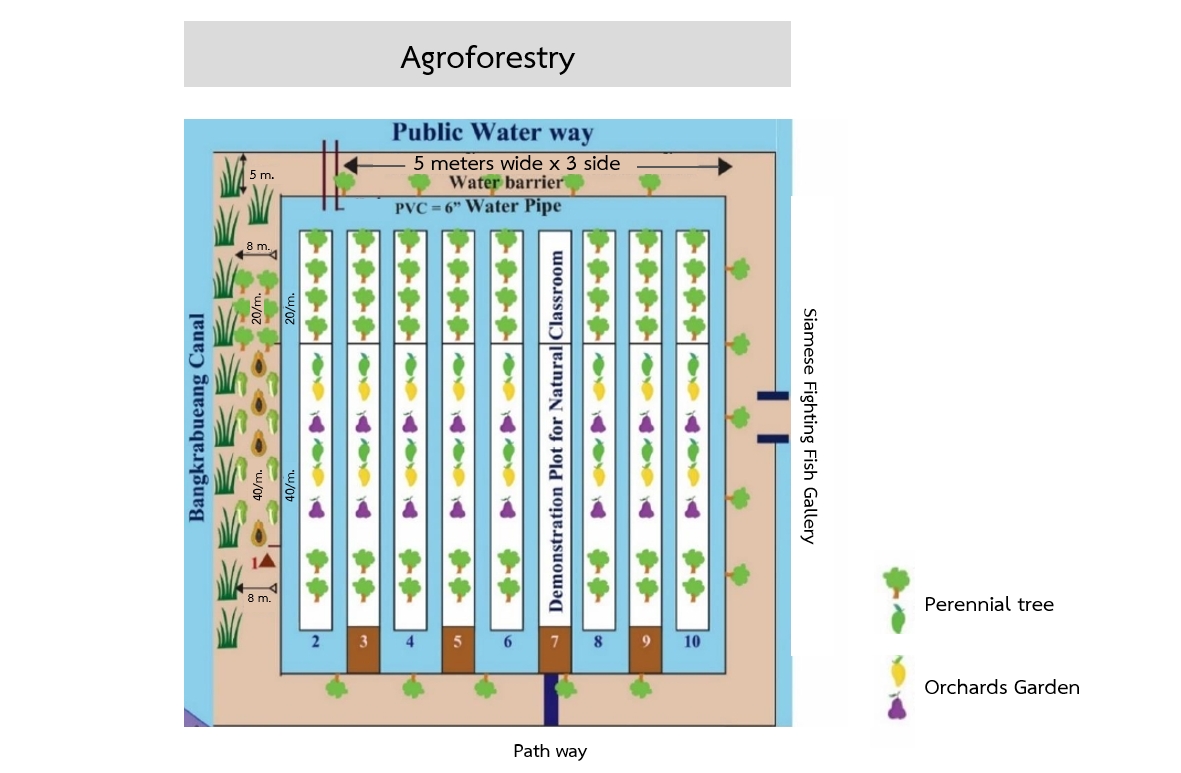
ข้อมูลจำเพาะด้านเทคนิค (แบบแปลนทางเทคนิคของเทคโนโลยี):
Tree planting in the brackish forest area is carried out in three levels:
Primary trees: These are native species in the area, primarily mangrove trees, which are highly tolerant to brackish and saline water conditions that persist for over six months of the year. Examples of planted species include Tin Pet Nam (Cerbera odollam Gaertn.) and Indian Tulip Tree (Thespesia populnea).
Secondary trees: These include edible trees, both fruit-bearing and leafy vegetables, which are resistant to brackish and saline conditions. Examples are Tamarind (Tamarindus indica) and Neem (Azadirachta indica).
Herbal plants: These are various herbs that grow well under the shade of larger trees. Examples include Betel Leaves (Piper sarmentosum), Nightshade (Solanum indicum) and Pandan Leaves (Pandanus amaryllifolius).
4.2 ข้อมูลทั่วไปเกี่ยวกับการคำนวณปัจจัยนำเข้าและค่าใช้จ่าย
ให้ระบุว่าค่าใช้จ่ายและปัจจัยนำเข้าได้รับการคำนวณอย่างไร:
- ต่อพื้นที่ที่ใช้เทคโนโลยี
ระบุขนาดและหน่วยพื้นที่:
2.56 ha
If using a local area unit, indicate conversion factor to one hectare (e.g. 1 ha = 2.47 acres): 1 ha =:
6.25 rai
ระบุสกุลเงินที่ใช้คำนวณค่าใช้จ่าย:
- USD
ระบุค่าเฉลี่ยของค่าจ้างในการจ้างแรงงานต่อวัน:
8.82 USD
4.3 กิจกรรมเพื่อการจัดตั้ง
| กิจกรรม | Timing (season) | |
|---|---|---|
| 1. | Main plants refer to local plants in the area, namely plants in mangrove forests which are tolerant to being brackish and salinity of natural water resources for more than 6 months per year. The plants grown are Cerbera odollam, Indian laurel, Bruguiera sexangul, Intsia bijuga, Thespesia populnea, cork tree and Copper pod. | |
| 2. | Secondary plants refer to edible plants for fruit trees and plants with edible leaves. These plants are tolerant to brackish conditions and salinity such as tamarind, neem, Cassod tree, Great morinda, Luna nut, Ardisia polycephala | |
| 3. | Medicinal plants thriving well under shade of big trees such as Piper Samentosum, Solanum incanum, Pandanus leaf, Cordyline fruticosa, Sea holly |
4.4 ค่าใช้จ่ายของปัจจัยนำเข้าที่จำเป็นสำหรับการจัดตั้ง
| ปัจจัยนำเข้า | หน่วย | ปริมาณ | ค่าใช้จ่ายต่อหน่วย | ค่าใช้จ่ายทั้งหมดต่อปัจจัยนำเข้า | %ของค่าใช้จ่ายที่ก่อให้เกิดขึ้นโดยผู้ใช้ที่ดิน | |
|---|---|---|---|---|---|---|
| แรงงาน | Deepen the garden ditch in the area of 2.56 ha | Bed | 50.0 | 17.6 | 880.0 | 100.0 |
| อุปกรณ์ | Water pump | Machine | 2.0 | 147.0 | 294.0 | 100.0 |
| อุปกรณ์ | Compost | Tonne | 30.0 | 29.4 | 882.0 | 100.0 |
| อุปกรณ์ | 15-15-15 chemical fertilizer | Sack | 20.0 | 29.4 | 588.0 | 100.0 |
| อุปกรณ์ | Lime | Tonne | 10.0 | 88.2 | 882.0 | 100.0 |
| อุปกรณ์ | 500 liter plastic bucked | BucKed | 5.0 | 58.8 | 294.0 | 100.0 |
| อุปกรณ์ | Water salinity meter | Machine | 2.0 | 29.4 | 58.8 | 100.0 |
| อุปกรณ์ | 8 inch PVC with the length of 3 meters | Piece | 3.0 | 29.4 | 88.2 | 100.0 |
| วัสดุด้านพืช | Plant varieties including planting labor costs in the area of 2.56 ha | Tree | 10000.0 | 0.15 | 1500.0 | 100.0 |
| อื่น ๆ | Materials used in building the nursery including labor costs | Square meters | 20.0 | 29.4 | 588.0 | 100.0 |
| ค่าใช้จ่ายทั้งหมดของการจัดตั้งเทคโนโลยี | 6055.0 | |||||
| Total costs for establishment of the Technology in USD | 6055.0 | |||||
แสดงความคิดเห็น:
External organizations and government agencies contribute by offering essential financial and technical support to local communities.
4.5 การบำรุงรักษาสภาพหรือกิจกรรมที่เกิดขึ้นเป็นประจำ
| กิจกรรม | ช่วงระยะเวลา/ความถี่ | |
|---|---|---|
| 1. | weed removal | |
| 2. | fertilizer application | |
| 3. | tillage | |
| 4. | planting for repairing and maintaining trees in the cultivation plot |
4.6 ค่าใช้จ่ายของปัจจัยนำเข้าและกิจกรรมที่เกิดขึ้นเป็นประจำที่ต้องการการบำรุงรักษา (ต่อปี)
| ปัจจัยนำเข้า | หน่วย | ปริมาณ | ค่าใช้จ่ายต่อหน่วย | ค่าใช้จ่ายทั้งหมดต่อปัจจัยนำเข้า | %ของค่าใช้จ่ายที่ก่อให้เกิดขึ้นโดยผู้ใช้ที่ดิน | |
|---|---|---|---|---|---|---|
| แรงงาน | Management during planting and maintenance (1 year) | Force | 1.0 | 352.8 | 352.8 | 100.0 |
| อื่น ๆ | Electricity costs | USD | 12.0 | 14.7 | 176.4 | 100.0 |
| ค่าใช้จ่ายทั้งหมดของการบำรุงรักษาสภาพเทคโนโลยี | 529.2 | |||||
| Total costs for maintenance of the Technology in USD | 529.2 | |||||
แสดงความคิดเห็น:
External organizations and government agencies contribute by offering essential financial and technical support to local communities.
4.7 ปัจจัยสำคัญที่สุดที่มีผลกระทบต่อค่าใช้จ่าย
ปัจจัยสำคัญที่สุดที่มีผลกระทบต่อค่าใช้จ่ายต่างๆ:
1. Labour cost
2. Agricultural materials costs
3. Construction materials costs
5. สิ่งแวดล้อมทางธรรมชาติและของมนุษย์
5.1 ภูมิอากาศ
ฝนประจำปี
- < 250 ม.ม.
- 251-500 ม.ม.
- 501-750 ม.ม.
- 751-1,000 ม.ม.
- 1,001-1,500 ม.ม.
- 1,501-2,000 ม.ม.
- 2,001-3,000 ม.ม.
- 3,001-4,000 ม.ม.
- > 4,000 ม.ม.
ระบุปริมาณน้ำฝนเฉลี่ยรายปี (ถ้ารู้) :หน่วย ม.ม.
1545.00
เขตภูมิอากาศเกษตร
- กึ่งชุ่มชื้น
5.2 สภาพภูมิประเทศ
ค่าเฉลี่ยความลาดชัน:
- ราบเรียบ (0-2%)
- ลาดที่ไม่ชัน (3-5%)
- ปานกลาง (6-10%)
- เป็นลูกคลื่น (11-15%)
- เป็นเนิน (16-30%)
- ชัน (31-60%)
- ชันมาก (>60%)
ธรณีสัณฐาน:
- ที่ราบสูง/ที่ราบ
- สันเขา
- ไหล่เขา
- ไหล่เนินเขา
- ตีนเนิน
- หุบเขา
ระดับความสูง:
- 0-100 เมตร
- 101-500 เมตร
- 501-1,000 เมตร
- 1,001-1,500 เมตร
- 1,501-2,000 เมตร
- 2,001-2,500 เมตร
- 2,501-3,000 เมตร
- 3,001-4,000 เมตร
- > 4,000 เมตร
ให้ระบุถ้าเทคโนโลยีได้ถูกนำไปใช้:
- ไม่เกี่ยวข้อง
5.3 ดิน
ค่าเฉลี่ยความลึกของดิน:
- ตื้นมาก (0-20 ซ.ม.)
- ตื้น (21-50 ซ.ม.)
- ลึกปานกลาง (51-80 ซ.ม.)
- ลึก (81-120 ซ.ม.)
- ลึกมาก (>120 ซ.ม.)
เนื้อดิน (ดินชั้นบน):
- ละเอียด/หนัก (ดินเหนียว)
เนื้อดินล่าง (> 20 ซ.ม.ต่ำจากผิวดิน):
- ละเอียด/หนัก (ดินเหนียว)
อินทรียวัตถุในดิน:
- ปานกลาง (1-3%)
(ถ้ามี) ให้แนบคำอธิบายเรื่องดินแบบเต็มหรือระบุข้อมูลที่มีอยู่ เช่น ชนิดของดิน ค่า pH ของดินหรือความเป็นกรดของดิน ความสามารถในการแลกเปลี่ยนประจุบวก ไนโตรเจน ความเค็ม เป็นต้น:
The soil is Samutprakarn soil series (Sm), soil series group 3. The parent material of soil is derived from marine sediments mixing with alluvial sediments. Soil reaction is moderately acidic to moderately alkaline (pH 6.6-8.0). The limitation factor of land-use is saline soil and be flooded by sea water.
5.4 ความเป็นประโยชน์และคุณภาพของน้ำ
น้ำไหลบ่าที่ผิวดิน:
ดี
คุณภาพน้ำ (ที่ยังไม่ได้บำบัด):
เป็นน้ำใช้เพื่อการเกษตรเท่านั้น (การชลประทาน)
Water quality refers to:
surface water
ความเค็มของน้ำเป็นปัญหาหรือไม่:
ใช่
ระบุ:
land-use is flooded by sea water
กำลังเกิดน้ำท่วมในพื้นที่หรือไม่:
ใช่
บ่อยครั้ง:
บ่อยครั้ง
5.5 ความหลากหลายทางชีวภาพ
ความหลากหลายทางชนิดพันธุ์:
- สูง
ความหลากหลายของแหล่งที่อยู่:
- สูง
ความคิดเห็นและข้อมูลจำเพาะเพิ่มเติมของความหลากหลายทางชีวภาพ:
The area features a unique geography and environment, located within a horseshoe-shaped bend of the Chao Phraya River, which forms a natural buffer between urban Bangkok and its surroundings. This distinctive setting fosters a diverse range of aquatic, riparian, and terrestrial ecosystems, supporting a rich array of plant and animal life. Additionally, the region encompasses various habitats, including mangroves and wetlands that serve as vital refuges for numerous bird species, fish, and amphibians. The forested areas, with their abundance of native tree species, provide essential shelter and food for many wildlife species.
5.6 ลักษณะของผู้ใช้ที่ดินที่นำเทคโนโลยีไปปฏิบัติใช้
อยู่กับที่หรือเร่ร่อน:
- อยู่กับที่
แนวทางการตลาดของระบบการผลิต:
- mixed (subsistence/ commercial)
ระดับของความมั่งคั่งโดยเปรียบเทียบ:
- พอมีพอกิน
เป็นรายบุคคล/ครัวเรือน:
- กลุ่ม/ชุมชน
ระดับของการใช้เครื่องจักรกล:
- งานที่ใช้แรงกาย
- การใช้เครื่องจักรหรือเครื่องยนต์
เพศ:
- ชาย
อายุของผู้ใช้ที่ดิน:
- วัยกลางคน
- ผู้สูงอายุ
5.7 Average area of land used by land users applying the Technology
- < 0.5 เฮกตาร์
- 0.5-1 เฮกตาร์
- 1-2 เฮกตาร์
- 2-5 เฮกตาร์
- 5-15 เฮกตาร์
- 15-50 เฮกตาร์
- 50-100 เฮกตาร์
- 100-500 เฮกตาร์
- 500-1,000 เฮกตาร์
- 1,000-10,000 เฮกตาร์
- >10,000 เฮกตาร์
พิจารณาว่าเป็นขนาดเล็ก กลาง หรือขนาดใหญ่ (ซึ่งอ้างอิงถึงบริบทระดับท้องถิ่น):
- ขนาดกลาง
5.8 กรรมสิทธิ์ในที่ดิน สิทธิในการใช้ที่ดินและสิทธิในการใช้น้ำ
กรรมสิทธิ์ในที่ดิน:
- รัฐ
สิทธิในการใช้ที่ดิน:
- เกี่ยวกับชุมชน (ถูกจัดระเบียบ)
สิทธิในการใช้น้ำ:
- เข้าถึงได้แบบเปิด (ไม่ได้จัดระเบียบ)
Are land use rights based on a traditional legal system?
ใช่
5.9 การเข้าถึงบริการและโครงสร้างพื้นฐาน
สุขภาพ:
- จน
- ปานกลาง
- ดี
การศึกษา:
- จน
- ปานกลาง
- ดี
ความช่วยเหลือทางด้านเทคนิค:
- จน
- ปานกลาง
- ดี
การจ้างงาน (เช่น ภายนอกฟาร์ม):
- จน
- ปานกลาง
- ดี
ตลาด:
- จน
- ปานกลาง
- ดี
พลังงาน:
- จน
- ปานกลาง
- ดี
ถนนและการขนส่ง:
- จน
- ปานกลาง
- ดี
น้ำดื่มและการสุขาภิบาล:
- จน
- ปานกลาง
- ดี
บริการด้านการเงิน:
- จน
- ปานกลาง
- ดี
6. ผลกระทบและสรุปคำบอกกล่าว
6.1 ผลกระทบในพื้นที่ดำเนินการ (On-site) จากการใช้เทคโนโลยี
ผลกระทบด้านนิเวศวิทยา
ความหลากหลายทางชีวภาพของพืชและสัตว์
ความหลากหลายทางชีวภาพของพืช
แสดงความคิดเห็น/ระบุ:
Planting trees in the ecosystem of brackish-water forests and aquatic animal culture have brought about a variety of plant varieties and animal species such as egret.
ความหลากหลายทางชีวภาพของสัตว์
ความหลากหลายของสัตว์
6.2 ผลกระทบนอกพื้นที่ดำเนินการ (Off-site) จากการใช้เทคโนโลยี
การเกิดมลพิษในน้ำบาดาลหรือแม่น้ำ
แสดงความคิดเห็น/ระบุ:
Plants can lower groundwater levels, reducing salinity and waste water problems.
6.3 การเผชิญและความตอบสนองของเทคโนโลยีต่อการเปลี่ยนแปลงสภาพภูมิอากาศที่ค่อยเป็นค่อยไป และสภาพรุนแรงของภูมิอากาศ / ภัยพิบัติ (ที่รับรู้ได้โดยผู้ใช้ที่ดิน)
การเปลี่ยนแปลงสภาพภูมิอากาศที่ค่อยเป็นค่อยไป
การเปลี่ยนแปลงสภาพภูมิอากาศที่ค่อยเป็นค่อยไป
| ฤดู | increase or decrease | เทคโนโลยีมีวิธีการรับมืออย่างไร | |
|---|---|---|---|
| อุณหภูมิตามฤดูกาล | ฤดูแล้ง | ลดลง | ปานกลาง |
6.4 การวิเคราะห์ค่าใช้จ่ายและผลประโยชน์ที่ได้รับ
ผลประโยชน์ที่ได้รับเปรียบเทียบกับค่าใช้จ่ายในการจัดตั้งเป็นอย่างไร (จากมุมมองของผู้ใช้ที่ดิน)
ผลตอบแทนระยะสั้น:
ด้านบวกเล็กน้อย
ผลตอบแทนระยะยาว:
ด้านบวก
ผลประโยชน์ที่ได้รับเปรียบเทียบกับค่าใช้จ่ายในการบำรุงรักษาหรือต้นทุนที่เกิดขึ้นซ้ำอีก เป็นอย่างไร (จากมุมมองของผู้ใช้ที่ดิน)
ผลตอบแทนระยะสั้น:
เป็นกลางหรือสมดุล
ผลตอบแทนระยะยาว:
เป็นกลางหรือสมดุล
6.5 การปรับตัวของเทคโนโลยี
- ครั้งเดียวหรือเป็นการทดลอง
6.6 การปรับตัว
เทคโนโลยีได้รับการปรับเปลี่ยนเมื่อเร็วๆนี้ เพื่อให้ปรับตัวเข้ากับสภาพที่กำลังเปลี่ยนแปลงหรือไม่:
ไม่ใช่
6.7 จุดแข็ง / ข้อได้เปรียบ / โอกาสของเทคโนโลยี
| จุดแข็ง / ข้อได้เปรียบ / โอกาสในทัศนคติของผู้ใช้ที่ดิน |
|---|
| This technology contributes to environmental preservation and mitigates the burden of annual land ownership taxes, thereby promoting sustainable land use. |
| จุดแข็ง / ข้อได้เปรียบ / โอกาสในทัศนคติของผู้รวบรวมหรือวิทยากรหลัก |
|---|
| The technology aids in preserving soil and water fertility, restoring the environment, and sustainably expanding forested areas within urban communities. |
| Incorporating native plants and maintaining natural habitats can enhance biodiversity. |
6.8 จุดอ่อน / ข้อเสียเปรียบ / ความเสี่ยงของเทคโนโลยีและวิธีการแก้ไข
| จุดอ่อน / ข้อเสียเปรียบ / ความเสี่ยงในทัศนคติของผู้ใช้ที่ดิน | มีวิธีการแก้ไขได้อย่างไร |
|---|---|
| The technology has a relatively low economic return. | Developing land use practices in agriculture, fisheries, livestock, and other sectors is crucial. |
| จุดอ่อน / ข้อเสียเปรียบ / ความเสี่ยงในทัศนคติของผู้รวบรวมหรือวิทยากรหลัก | มีวิธีการแก้ไขได้อย่างไร |
|---|---|
| The technology significantly impacts the environment, however, its importance is not fully recognized by the community. | It is essential to develop more diverse land use patterns in agriculture, environmental management, and the tourism industry to generate income and ensure sustainable land use. |
| Low adoption of people around the project plot. | Increase local engagement and interest by host workshops or information sessions to introduce the project, explain benefits, and address any concerns from locals. |
7. การอ้างอิงและการเชื่อมต่อ
7.1 วิธีการและแหล่งข้อมูล
- ไปเยี่ยมชมภาคสนาม การสำรวจพื้นที่ภาคสนาม
8
- การสัมภาษณ์กับผู้ใช้ที่ดิน
1
- การสัมภาษณ์ผู้เชี่ยวชาญด้าน SLM หรือผู้ชำนาญ
5
7.3 Links to relevant online information
ชื่อเรื่องหรือคำอธิบาย:
Sustainable soil management practices in Asia
URL:
https://e-library.ldd.go.th/library/Ebook/bib10906.pdf
ลิงก์และโมดูล
ขยายทั้งหมด ย่อทั้งหมดลิงก์
ไม่มีลิงก์
โมดูล
ไม่มีโมดูล