Tree Plantation Pits in Arid Zones [ซาอุดีอาระเบีย]
- ผู้สร้างสรรค์:
- การอัพเดท:
- ผู้รวบรวม: Eric Lacroix
- ผู้เรียบเรียง: –
- ผู้ตรวจสอบ: William Critchley, Rima Mekdaschi Studer
Plantation pits
technologies_7380 - ซาอุดีอาระเบีย
ดูส่วนย่อย
ขยายทั้งหมด ย่อทั้งหมด1. ข้อมูลทั่วไป
1.2 รายละเอียดที่ติดต่อได้ของผู้รวบรวมและองค์กรที่เกี่ยวข้องในการประเมินและการจัดเตรียมทำเอกสารของเทคโนโลยี
ผู้ใช้ที่ดิน:
Al Eissa Abdullah
NCVC
ซาอุดีอาระเบีย
co-compiler:
co-compiler:
ผู้เชี่ยวชาญ SLM:
Boudi Dr. Nabeel
FAO
ซาอุดีอาระเบีย
ชื่อของโครงการซึ่งอำนวยความสะดวกในการทำเอกสารหรือการประเมินเทคโนโลยี (ถ้าเกี่ยวข้อง)
Sustainable Rural Agricultural Development Programme (UTF/SAU/051/SAU) (SRAD Saudi Arabia)ชื่อขององค์กรซึ่งอำนวยความสะดวกในการทำเอกสารหรือการประเมินเทคโนโลยี (ถ้าเกี่ยวข้อง)
FAO Saudi Arabia (FAO KSA)1.3 เงื่อนไขการใช้ข้อมูลที่ได้บันทึกผ่านทาง WOCAT
ผู้รวบรวมและวิทยากรหลักยอมรับเงื่อนไขเกี่ยวกับการใช้ข้อมูลที่ถูกบันทึกผ่านทาง WOCAT:
ใช่
1.4 การเปิดเผยเรื่องความยั่งยืนของเทคโนโลยีที่ได้อธิบายไว้
เทคโนโลยีที่ได้อธิบายไว้นี้เป็นปัญหาของความเสื่อมโทรมโทรมของที่ดินหรือไม่ จึงไม่ได้รับการยอมรับว่าเป็นเทคโนโลยีเพื่อการจัดการที่ดินอย่างยั่งยืน:
ไม่ใช่
แสดงความคิดเห็น:
This method allows sustainable plantations with a satisfactory level of success in hyper-arid zones (under 100 mm rainfall per year).
2. การอธิบายลักษณะของเทคโนโลยี SLM
2.1 การอธิบายแบบสั้น ๆ ของเทคโนโลยี
คำจำกัดความของเทคโนโลยี:
Tree plantation pits are water harvesting structures which capture rainfall runoff for trees and shrubs. They receive supplementary water until seedlings are well established. Species planted are indigenous, and provide both shade and honey.
2.2 การอธิบายแบบละเอียดของเทคโนโลยี
คำอธิบาย:
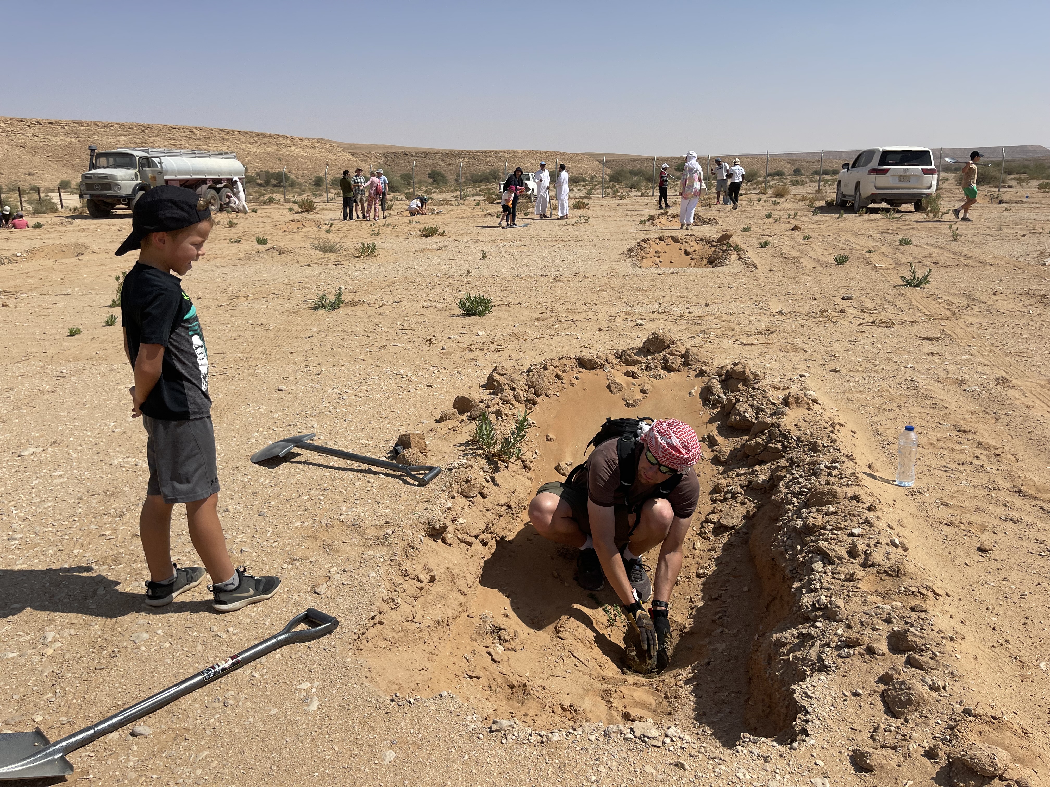
Plantation pits are water harvesting structures that capture rainfall runoff for planting trees and shrubs. They are given supplementary water until vegetation is established. The pits are dug within national parks managed by the National Centre for Vegetation Cover Development and Combating Desertification (NCVC), which is the leader in this technology.
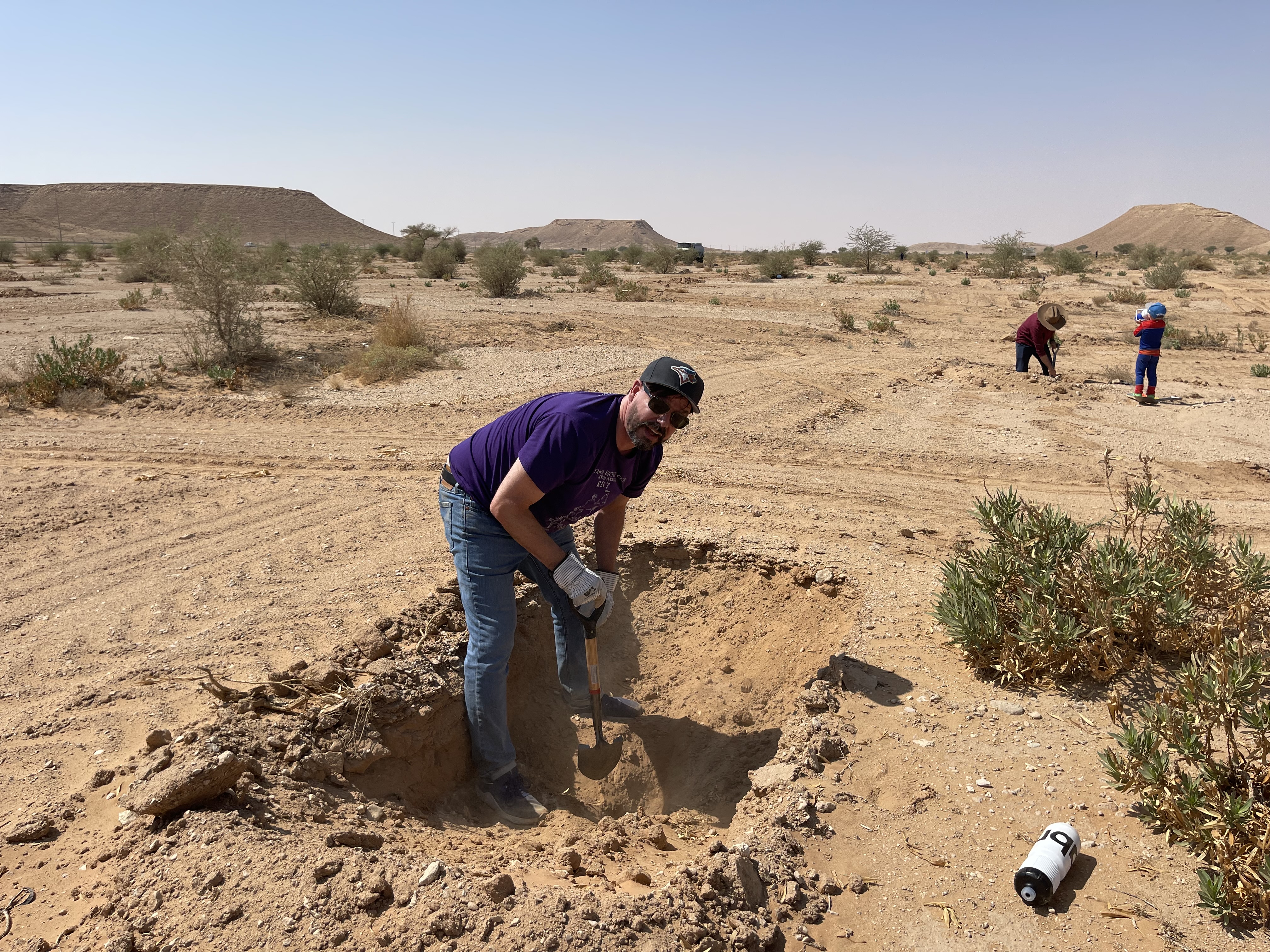
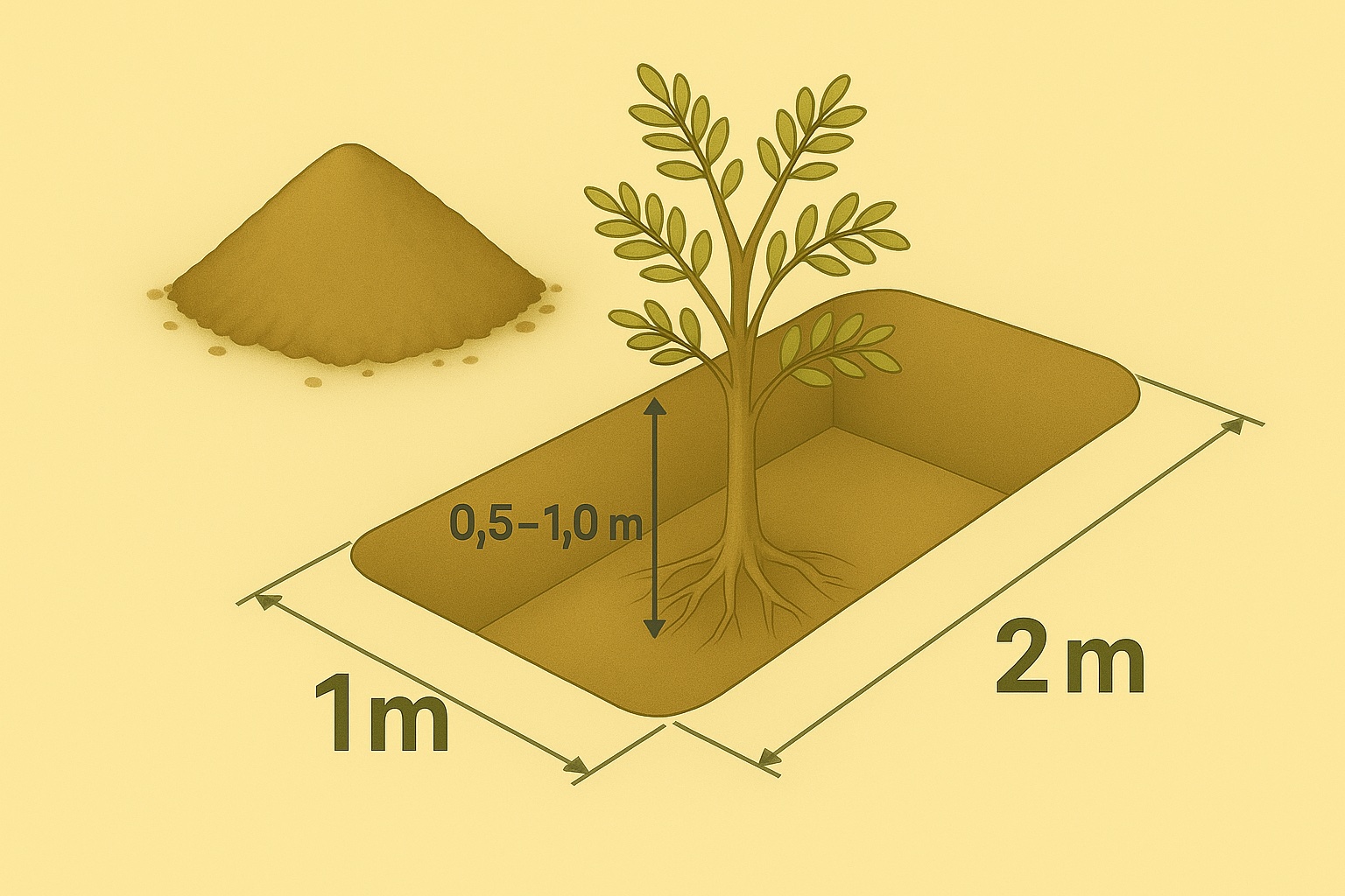
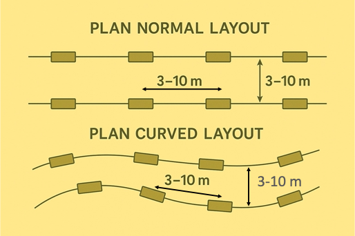
Pits may be located within wadis and sheyhib (small wadis), ranging in plots from ten to several hundred metres in length, and on high plateaux. The pits are often dug close to terraces and cross-wadi walls where runoff water is captured in the soil. Each plantation pit is rectangular, measuring (approx) 2m long, 1m wide, and up to 1m deep (depending on the depth of the soil). Spacing is from 3 to 10 metres between pits. The pits are excavated with mechanical diggers.
Pits are dug a year before planting, and they collect both runoff and the rich organic and mineral matter carried in the runoff. After one year, many annual and even perennial plants colonise the bottom of the pits. The trees and shrubs that are planted the most are Vachellia (Acacia) spp., Ziziphus spp. and Haxloylon spp. One (or two) seedlings are planted in the middle of each pit, without disturbing the existing vegetation as far as possible. These species attract bees, and beekeeping has been promoted alongside tree planting. Ziziphus honey is particularly high in value and Vachellia (acacia) honey is also good.
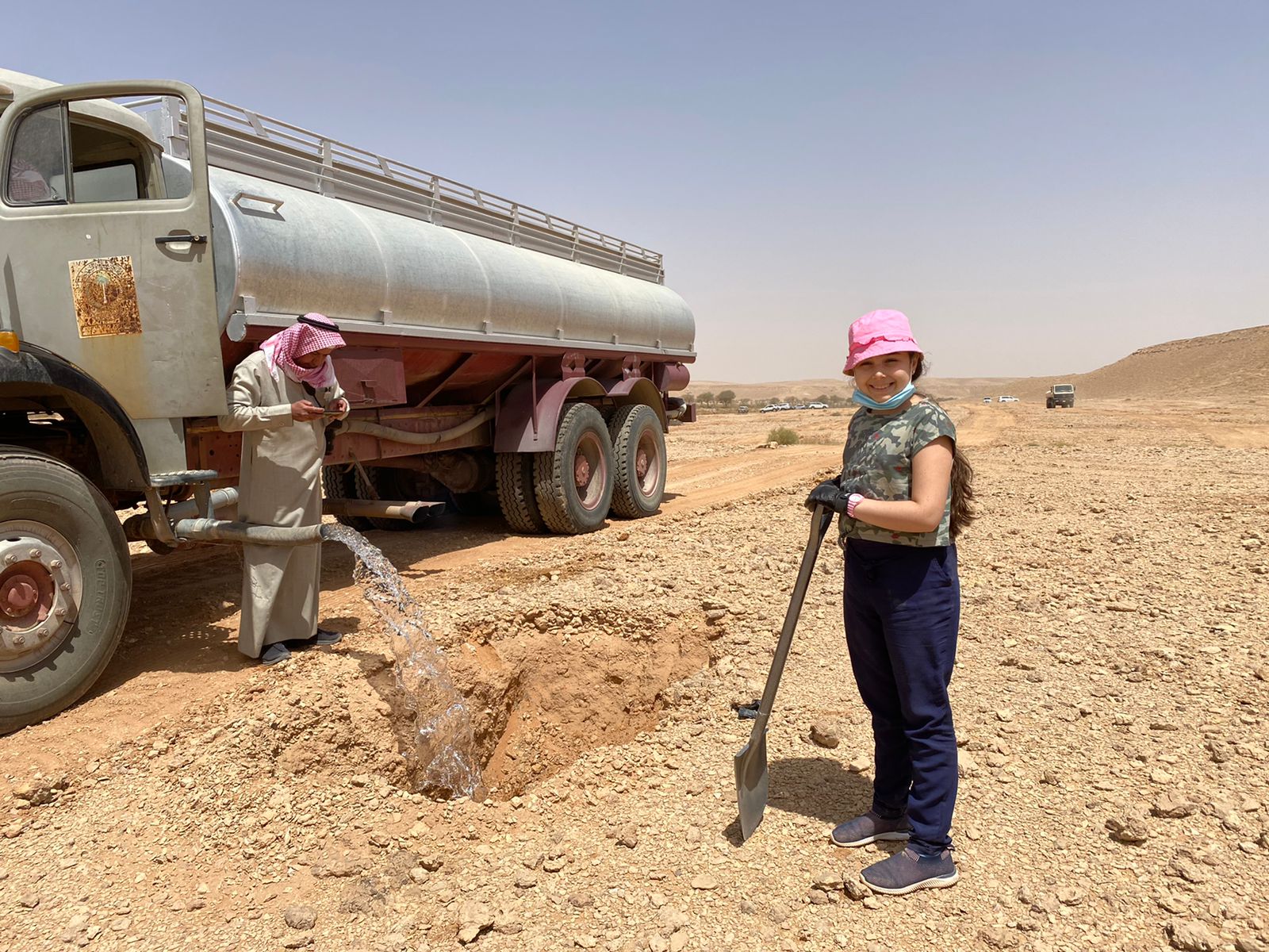
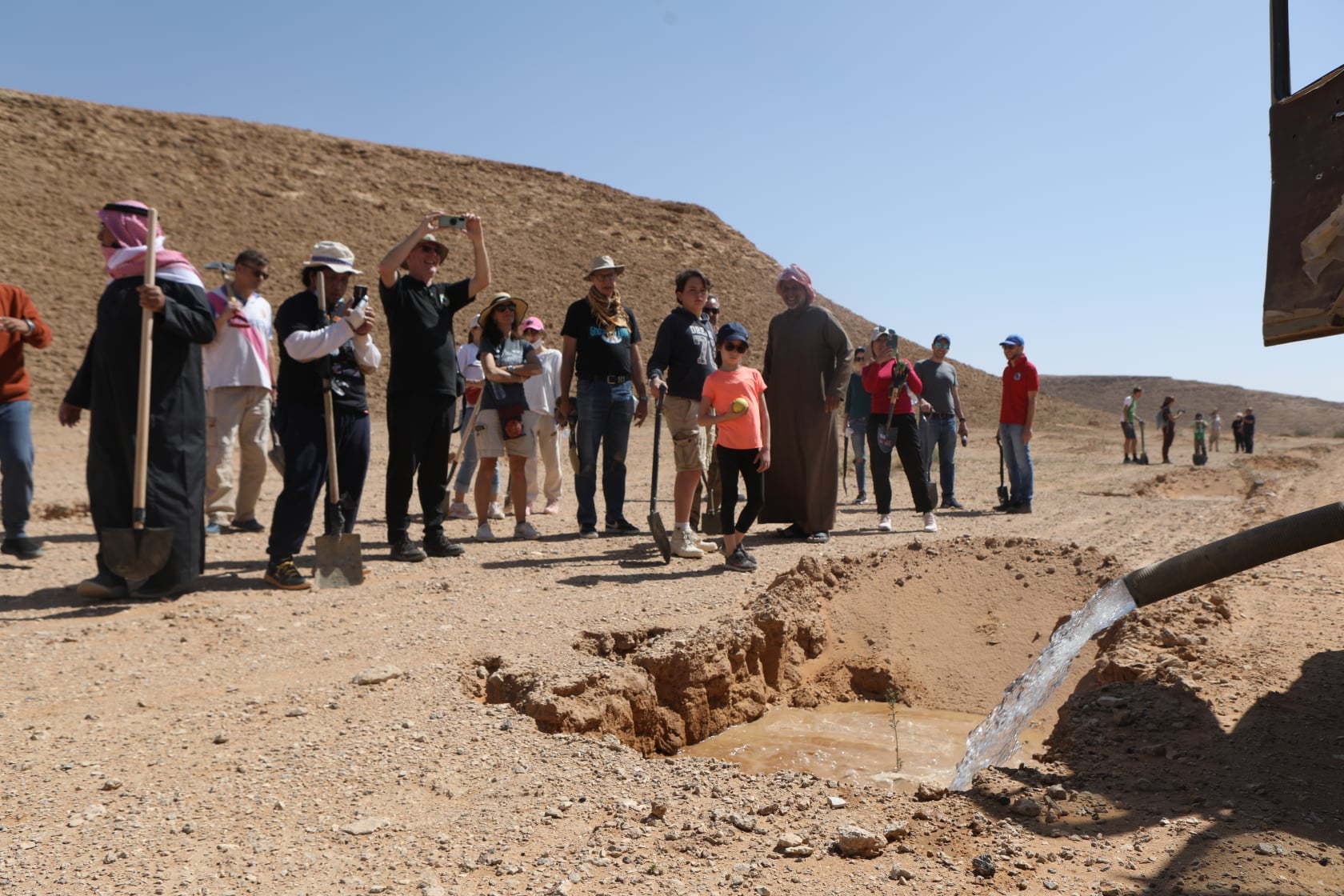
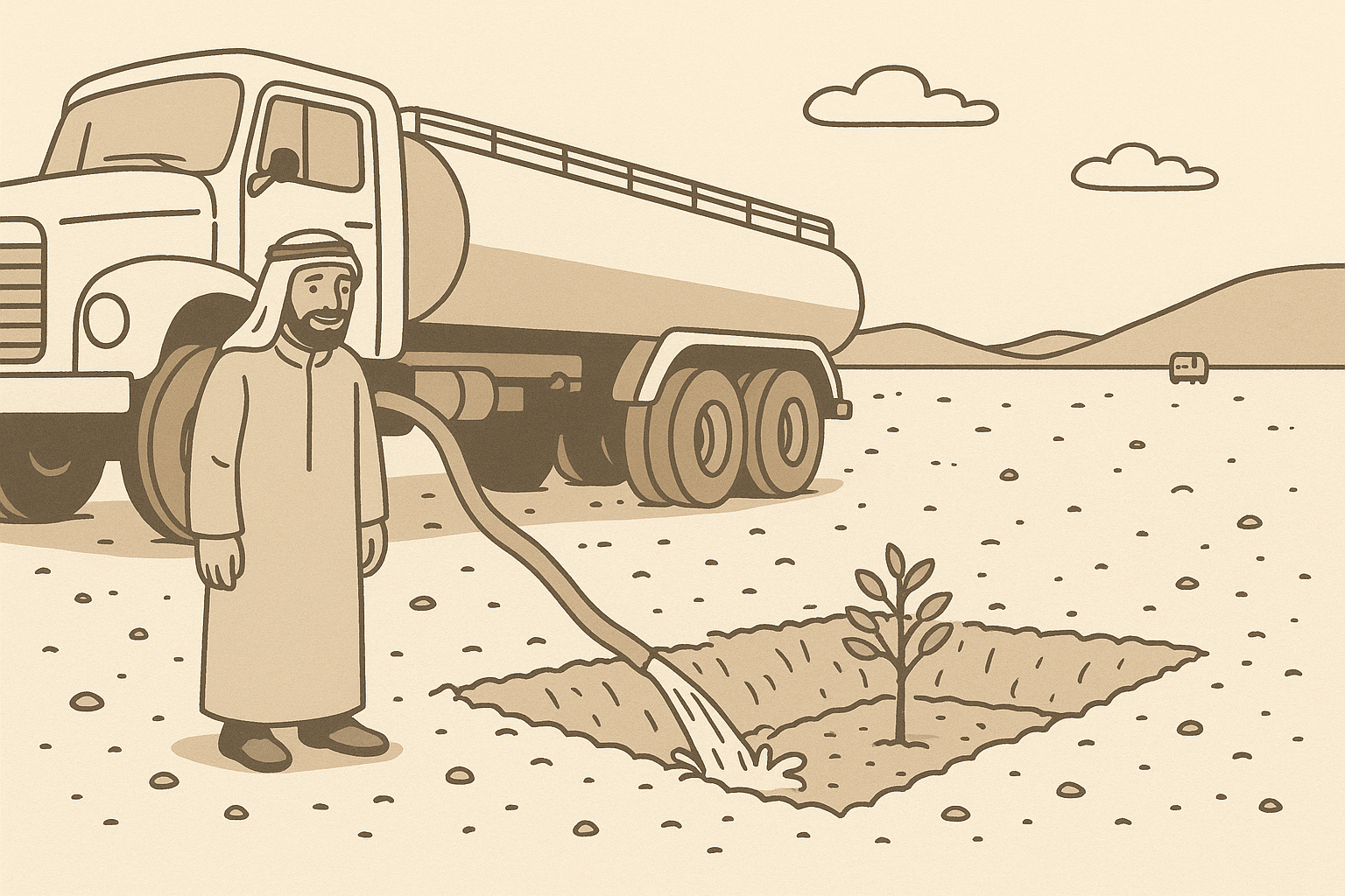
This water and nutrient harvesting technique is effective even in hyper-arid conditions, where rainfall may be less than 100 mm yearly. However, some supplemental irrigation is needed, and each pit is watered - every 4 months over 3 years - with a volume of water ranging from 20 to 100 litres each time per pit, depending on availability. Water is found in wadi beds and brought to the site in a bowser mounted on a lorry. Watering helps the plants to survive, and as it penetrates, it draws the roots down until they reach the water table. This is when watering can be stopped.
Although the costs are high, the results are generally very satisfactory regarding the survival rate. The local impact is significant when there are large blocks of pits and/ or greater numbers of pits per hectare (where this is possible). Over the last five years, a million pits have been dug.
Abdulla Al Eissa, the park manager, formulated the technical design of the pits, and FAO through the project "Strengthening MoEWA's Capacity to implement its Sustainable Rural Agricultural Development (SRAD) Programme (2019-2025) UTF/SAU/051/SAU" has been responsible for technical advice on locating pits, spacing and layout timing of operations, fertilization and planting operations. The activities are part-funded by the NCVC, while local donors and volunteers contribute the remainder.
2.3 รูปภาพของเทคโนโลยี
อัลบั้มสื่อบันทึก
2.4 วีดีโอของเทคโนโลยี
ความคิดเห็น/อธิบายสั้นๆ:
https://vimeo.com/1026092452?share=copy
วันที่:
04/11/2024
สถานที่:
Thadiq national park
ชื่อผู้ถ่ายวีดีโอ:
Abdullah Al Eissa
2.5 ประเทศภูมิภาค หรือสถานที่ตั้งที่เทคโนโลยีได้นำไปใช้และได้รับการครอบคลุมโดยการประเมินนี้
ประเทศ:
ซาอุดีอาระเบีย
ภูมิภาค/รัฐ/จังหวัด:
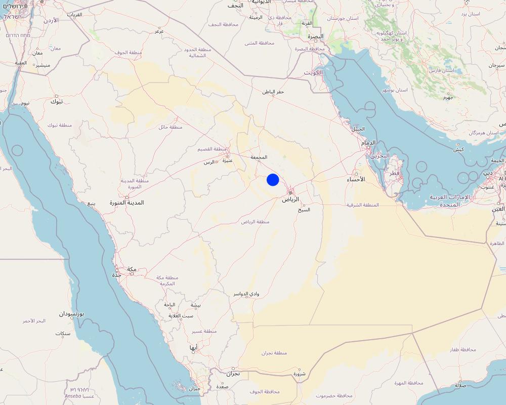
Riyadh Region (Province)
ข้อมูลจำเพาะเพิ่มเติมของสถานที่ตั้ง :
Thadiq National Park
ระบุการกระจายตัวของเทคโนโลยี:
- กระจายไปอย่างสม่ำเสมอในพื้นที่
If the Technology is evenly spread over an area, specify area covered (in km2):
148.0
If precise area is not known, indicate approximate area covered:
- 100-1,000 ตร.กม.
Is/are the technology site(s) located in a permanently protected area?
ใช่
ถ้าใช่ ระบุ:
Dispersed within Thadiq National Park
แสดงความคิดเห็น:
This is a protected area (category V), IUCN, not yet registered in WDPA, 145 SQKM. This protected area is within the North Riyadh Geopark UNESCO (3000 SQKM). In the future, the National Park may extend and become a IUCN Protected area Category II.
Map
×2.6 วันที่การดำเนินการ
ระบุปีที่ใช้:
2019
ถ้าไม่รู้ปีที่แน่นอน ให้ระบุวันที่โดยประมาณ:
- น้อยกว่า 10 ปี (ไม่นานนี้)
2.7 คำแนะนำของเทคโนโลยี
ให้ระบุว่าเทคโนโลยีถูกแนะนำเข้ามาอย่างไร:
- ทางโครงการหรือจากภายนอก
ความคิดเห็น (ประเภทของโครงการ เป็นต้น) :
Pits are established under a project which sets out to develop vegetation to protect the environment in the National Parks and to support tourism in the region, partly financed by the NCVC (paying for workmen's salaries, etc. ) and local donors (trucks, machines) and volunteers planting.
3. การจัดประเภทของเทคโนโลยี SLM
3.1 วัตถุประสงค์หลักของเทคโนโลยี
- ลด ป้องกัน ฟื้นฟู การเสื่อมโทรมของที่ดิน
- อนุรักษ์ระบบนิเวศน์
- รักษาสภาพหรือปรับปรุงความหลากหลายทางชีวภาพ
- สร้างผลกระทบทางด้านเศรษฐกิจที่เป็นประโยชน์
- สร้างผลกระทบทางด้านสังคมที่เป็นประโยชน์
3.2 ประเภทของการใช้ที่ดินในปัจจุบันที่ได้นำเทคโนโลยีไปใช้
Land use mixed within the same land unit:
ไม่ใช่

ป่า/พื้นที่ทำไม้
- ป่ากึ่งธรรมชาติ / พื้นที่ทำไม้
- ป่า/พื้นที่ทำไม้
(Semi-)natural forests/ woodlands: Specify management type:
- การใช้ประโยชน์จากป่า ยกเว้นไม้
Type of (semi-)natural forest:
- subtropical dry forest natural vegetation
Tree plantation, afforestation: Specify origin and composition of species:
- การปลูกหลายพันธุ์รวมกัน
Type of tree plantation, afforestation:
- subtropical dry forest plantation
- subtropical dry forest plantation - Broadleaf
Type of tree:
- Acacia species
- Acacia tortilis
- Ziziphus mauritiana
- Balanites aegyptiaca
Are the trees specified above deciduous or evergreen?
- deciduous
ผลิตภัณฑ์และบริการ:
- การอนุรักษ์ / ป้องกันธรรมชาติ
- นันทนาการ / การท่องเที่ยว
- การป้องกันภัยธรรมชาติ
แสดงความคิดเห็น:
The Royal Botanical Garden Kew's Plants of the World website now uses the name Vachellia for the genus formerly known as Acacia.
3.3 Has land use changed due to the implementation of the Technology?
Has land use changed due to the implementation of the Technology?
- Yes (Please fill out the questions below with regard to the land use before implementation of the Technology)

ที่ดินที่ไม่ให้ผลผลิต
3.4 การใช้น้ำ
การใช้น้ำของที่ดินที่มีการใช้เทคโนโลยีอยู่:
- น้ำฝนร่วมกับการชลประทาน
แสดงความคิดเห็น:
Supplementary water sourced from wadi beds (3 deep wells with electrical pumps).
3.5 กลุ่ม SLM ที่ตรงกับเทคโนโลยีนี้
- การจัดการป่าธรรมชาติและกึ่งธรรมชาติ
- การเก็บเกี่ยวน้ำ
- การเลี้ยงผึ้ง การเพาะเลี้ยงสัตว์น้ำ สัตว์ปีก ฟาร์มกระต่าย ฟาร์มหนอนไหม
3.6 มาตรการ SLM ที่ประกอบกันเป็นเทคโนโลยี

มาตรการอนุรักษ์ด้วยวิธีพืช
- V1: ต้นไม้และพุ่มไม้คลุมดิน

มาตรการอนุรักษ์ด้วยโครงสร้าง
- S4: คูน้ำแนวระดับ หลุม
- S7: การกักเก็บน้ำ/การส่งลำเลียง/อุปกรณ์การชลประทาน
3.7 รูปแบบหลักของการเสื่อมโทรมของที่ดินที่ได้รับการแก้ไขโดยเทคโนโลยี

การกัดกร่อนของดินโดยน้ำ
- Wt (Loss of topsoil): การสูญเสียดินชั้นบนหรือการกัดกร่อนที่ผิวดิน
- Wg (Gully erosion): การกัดกร่อนแบบร่องธารหรือการทำให้เกิดร่องน้ำเซาะ
- Wo (Offsite degradation): ผลกระทบนอกพื้นที่

การเสื่อมโทรมของดินทางด้านกายภาพ
- Pk (Slaking and crusting): การอุดตันของช่องว่างในดินหรือรูพรุน
- Pu (Loss of bio-productive function): การสูญเสียหน้าที่การผลิตทางชีวภาพอันเนื่องมาจากกิจกรรม อื่นๆ

การเสื่อมโทรมของดินทางด้านชีวภาพ
- Bc (Reduction of vegetation cover): การลดลงของจำนวนพืชที่ปกคลุมดิน
- Bh (Loss of habitat): การสูญเสียแหล่งที่อยู่
- Bq (Quantity/biomass decline): การลดลงของปริมาณหรือมวลชีวภาพ
- Bs (Quality and species composition): องค์ประกอบหรือความหลากหลายทางคุณภาพและชนิดพันธุ์ลดลง
- Bl (Loss of soil life): การสูญเสียสิ่งมีชีวิตในดิน

การเสื่อมโทรมของน้ำ
- Ha (Aridification): การเกิดความแห้งแล้ง
- Hs (Change in quantity of surface water): การเปลี่ยนแปลงปริมาณของน้ำที่ผิวดิน
- Hg (Change in groundwater): การเปลี่ยนแปลงของน้ำบาดาลหรือระดับน้ำในแอ่งน้ำบาดาล
- Hp (Decline of surface water quality): การลดลงของคุณภาพน้ำที่ผิวดิน
- Hq (Decline of groundwater quality): การลดลงของคุณภาพน้ำบาดาล
3.8 การป้องกัน การลดลง หรือการฟื้นฟูความเสื่อมโทรมของที่ดิน
ระบุเป้าหมายของเทคโนโลยีกับความเสื่อมโทรมของที่ดิน:
- ลดความเสื่อมโทรมของดิน
4. ข้อมูลจำเพาะด้านเทคนิค กิจกรรมการนำไปปฏิบัติใช้ ปัจจัยนำเข้า และค่าใช้จ่าย
4.1 แบบแปลนทางเทคนิคของเทคโนโลยี
ข้อมูลจำเพาะด้านเทคนิค (แบบแปลนทางเทคนิคของเทคโนโลยี):
Each pit is 2 m long, 1m wide, up to 1m deep, spacing from 3 to 10 meters between structures in curved lines, or 3 meters apart in clusters. Watering with 20 to 100 litres depending on the availability and price of water and cost of transportation and watering. 100 pits minimum per hectare (maximum 1100, which is rare in this environment). One to three seedlings (tree, shrub, plant) per pit.
ผู้เขียน:
Éric Lacroix,
วันที่:
04/11/2024
ข้อมูลจำเพาะด้านเทคนิค (แบบแปลนทางเทคนิคของเทคโนโลยี):
Watering system: truck with bowser (tank) and hose
ผู้เขียน:
ChatGPT based on an image and explanations.
วันที่:
04/05/2025
ข้อมูลจำเพาะด้านเทคนิค (แบบแปลนทางเทคนิคของเทคโนโลยี):
Between lines and between pits: 3-10 meters. In lines or in curves or at random.
ผู้เขียน:
ChatGPT based on an image and instructions.
วันที่:
06/05/2025
4.2 ข้อมูลทั่วไปเกี่ยวกับการคำนวณปัจจัยนำเข้าและค่าใช้จ่าย
ให้ระบุว่าค่าใช้จ่ายและปัจจัยนำเข้าได้รับการคำนวณอย่างไร:
- ต่อพื้นที่ที่ใช้เทคโนโลยี
ระบุขนาดและหน่วยพื้นที่:
hectare with 100 pits
ระบุสกุลเงินที่ใช้คำนวณค่าใช้จ่าย:
- USD
ระบุค่าเฉลี่ยของค่าจ้างในการจ้างแรงงานต่อวัน:
33-50 dollars
4.3 กิจกรรมเพื่อการจัดตั้ง
| กิจกรรม | Timing (season) | |
|---|---|---|
| 1. | Identify the site | Dry season: Year 1 |
| 2. | Layout and mark the pits with stakes | Dry season: Year 1 |
| 3. | Dig the pits | Dry season: Year 1 |
| 4. | Produce the seedlings in a nursery | Dry season: Year 1 |
| 5. | Plant the seedlings | Rainy season: Year 2 |
| 6. | Water the seedlings (and replace dead ones) | Dry season: Years 2-4 |
| 7. | Check the pits during the first rain. | Rainy season: Years 2-4 |
| 8. | Check the pits after flooding | After flooding: Years 2-4 |
แสดงความคิดเห็น:
Based on a 4 year period - with trees seedlings planted 1 year after the pits are dug.
4.4 ค่าใช้จ่ายของปัจจัยนำเข้าที่จำเป็นสำหรับการจัดตั้ง
| ปัจจัยนำเข้า | หน่วย | ปริมาณ | ค่าใช้จ่ายต่อหน่วย | ค่าใช้จ่ายทั้งหมดต่อปัจจัยนำเข้า | %ของค่าใช้จ่ายที่ก่อให้เกิดขึ้นโดยผู้ใช้ที่ดิน | |
|---|---|---|---|---|---|---|
| แรงงาน | Workers for planting | Worker/day | 5.0 | 50.0 | 250.0 | 90.0 |
| แรงงาน | Workers for watering | Worker/day | 18.0 | 33.0 | 594.0 | 90.0 |
| อุปกรณ์ | Excavator for digging pits (2 x 2 x 1 m) 100 pits /ha | Hour | 25.0 | 93.0 | 2325.0 | 90.0 |
| อุปกรณ์ | Truck with bowser/ tank for watering (100 litres /pit / 9 times over 3 years) | Truck/ 5000 litres | 18.0 | 47.0 | 846.0 | 90.0 |
| วัสดุด้านพืช | Tree Seedlings 200 /ha | Seedling | 200.0 | 4.0 | 800.0 | |
| ค่าใช้จ่ายทั้งหมดของการจัดตั้งเทคโนโลยี | 4815.0 | |||||
| Total costs for establishment of the Technology in USD | 4815.0 | |||||
ถ้าผู้ใช้ที่ดินรับภาระน้อยกว่า 100% ของค่าใช้จ่าย ให้ระบุว่าใครเป็นผู้รับผิดชอบส่วนที่เหลือ:
The costs are paid through the National Park: 90% from private donations/ volunteer work and 10% by the National Center for Vegetation Cover NCVC. Seedlings supplied by NCVC.
แสดงความคิดเห็น:
The costs are spread over 4 years, by hectare, for 100 pits, including digging, planting - and watering for 3 years.
4.5 การบำรุงรักษาสภาพหรือกิจกรรมที่เกิดขึ้นเป็นประจำ
| กิจกรรม | ช่วงระยะเวลา/ความถี่ | |
|---|---|---|
| 1. | Checking the pits after the first rain | Once, after the first rain. |
| 2. | Checking the pits after floodings | After flooding. |
| 3. | Replacing seedlings when needed (with extra watering if necessary). | During the wet season |
แสดงความคิดเห็น:
Depending on the climate
4.6 ค่าใช้จ่ายของปัจจัยนำเข้าและกิจกรรมที่เกิดขึ้นเป็นประจำที่ต้องการการบำรุงรักษา (ต่อปี)
| ปัจจัยนำเข้า | หน่วย | ปริมาณ | ค่าใช้จ่ายต่อหน่วย | ค่าใช้จ่ายทั้งหมดต่อปัจจัยนำเข้า | %ของค่าใช้จ่ายที่ก่อให้เกิดขึ้นโดยผู้ใช้ที่ดิน | |
|---|---|---|---|---|---|---|
| แรงงาน | Workers for maintenance including repairs, weeding and planting replacement seedlings | Worker/day | 10.0 | 50.0 | 500.0 | 100.0 |
| วัสดุด้านพืช | Tree seedlings | seedling | 30.0 | 4.0 | 120.0 | |
| ค่าใช้จ่ายทั้งหมดของการบำรุงรักษาสภาพเทคโนโลยี | 620.0 | |||||
| Total costs for maintenance of the Technology in USD | 620.0 | |||||
ถ้าผู้ใช้ที่ดินรับภาระน้อยกว่า 100% ของค่าใช้จ่าย ให้ระบุว่าใครเป็นผู้รับผิดชอบส่วนที่เหลือ:
Local donors 100 % of workers costs and NCVC 100 % of the seedlings.
แสดงความคิดเห็น:
Depending on the type of soil, drought and flooding. Figures are an average per year for first few years. Extra watering may be necessary at an extra cost for the truck/ bowser (not costed here).
4.7 ปัจจัยสำคัญที่สุดที่มีผลกระทบต่อค่าใช้จ่าย
ปัจจัยสำคัญที่สุดที่มีผลกระทบต่อค่าใช้จ่ายต่างๆ:
Type of soil, drought and flooding.
5. สิ่งแวดล้อมทางธรรมชาติและของมนุษย์
5.1 ภูมิอากาศ
ฝนประจำปี
- < 250 ม.ม.
- 251-500 ม.ม.
- 501-750 ม.ม.
- 751-1,000 ม.ม.
- 1,001-1,500 ม.ม.
- 1,501-2,000 ม.ม.
- 2,001-3,000 ม.ม.
- 3,001-4,000 ม.ม.
- > 4,000 ม.ม.
ระบุปริมาณน้ำฝนเฉลี่ยรายปี (ถ้ารู้) :หน่วย ม.ม.
70.00
ข้อมูลจำเพาะ/ความคิดเห็นเรื่องปริมาณน้ำฝน:
The distribution and seasonality of rainfall in Riyadh, Saudi Arabia, are characterized by low annual totals, high variability, and a distinct seasonal pattern associated with its arid desert climate.
ระบุชื่อของสถานีตรวดวัดอากาศที่ใช้อ้างอิงคือ:
Internet, available climate data
เขตภูมิอากาศเกษตร
- แห้งแล้ง
Arid or hyper-arid, to be exact. Riyadh region, in general, experiences a hot desert climate. Summers are extremely hot, with temperatures often exceeding 45°C (113°F), while winters are mild, with daytime temperatures averaging around 20°C (68°F). Rainfall is scarce and irregular, mostly occurring between November and April, with an annual average of less than 100 mm.
5.2 สภาพภูมิประเทศ
ค่าเฉลี่ยความลาดชัน:
- ราบเรียบ (0-2%)
- ลาดที่ไม่ชัน (3-5%)
- ปานกลาง (6-10%)
- เป็นลูกคลื่น (11-15%)
- เป็นเนิน (16-30%)
- ชัน (31-60%)
- ชันมาก (>60%)
ธรณีสัณฐาน:
- ที่ราบสูง/ที่ราบ
- สันเขา
- ไหล่เขา
- ไหล่เนินเขา
- ตีนเนิน
- หุบเขา
ระดับความสูง:
- 0-100 เมตร
- 101-500 เมตร
- 501-1,000 เมตร
- 1,001-1,500 เมตร
- 1,501-2,000 เมตร
- 2,001-2,500 เมตร
- 2,501-3,000 เมตร
- 3,001-4,000 เมตร
- > 4,000 เมตร
ให้ระบุถ้าเทคโนโลยีได้ถูกนำไปใช้:
- ไม่เกี่ยวข้อง
ความคิดเห็นและข้อมูลจำเพาะเพิ่มเติมเรื่องสภาพภูมิประเทศ:
This technology is specific to the Thuwayq wadis and plateaus
5.3 ดิน
ค่าเฉลี่ยความลึกของดิน:
- ตื้นมาก (0-20 ซ.ม.)
- ตื้น (21-50 ซ.ม.)
- ลึกปานกลาง (51-80 ซ.ม.)
- ลึก (81-120 ซ.ม.)
- ลึกมาก (>120 ซ.ม.)
เนื้อดิน (ดินชั้นบน):
- หยาบ/เบา (ดินทราย)
เนื้อดินล่าง (> 20 ซ.ม.ต่ำจากผิวดิน):
- หยาบ/เบา (ดินทราย)
อินทรียวัตถุในดิน:
- ต่ำ (<1%)
(ถ้ามี) ให้แนบคำอธิบายเรื่องดินแบบเต็มหรือระบุข้อมูลที่มีอยู่ เช่น ชนิดของดิน ค่า pH ของดินหรือความเป็นกรดของดิน ความสามารถในการแลกเปลี่ยนประจุบวก ไนโตรเจน ความเค็ม เป็นต้น:
Rocky limestone soils, sometimes sandy.
5.4 ความเป็นประโยชน์และคุณภาพของน้ำ
ระดับน้ำใต้ดิน:
5-50 เมตร
น้ำไหลบ่าที่ผิวดิน:
ไม่ดีหรือไม่มีเลย
คุณภาพน้ำ (ที่ยังไม่ได้บำบัด):
ใช้ประโยชน์ไม่ได้
Water quality refers to:
ground water
ความเค็มของน้ำเป็นปัญหาหรือไม่:
ไม่ใช่
กำลังเกิดน้ำท่วมในพื้นที่หรือไม่:
ใช่
บ่อยครั้ง:
เป็นครั้งเป็นคราว
ความคิดเห็นและข้อมูลจำเพาะเพิ่มเติมเรื่องคุณภาพและปริมาณน้ำ:
One to three floodings a year.
5.5 ความหลากหลายทางชีวภาพ
ความหลากหลายทางชนิดพันธุ์:
- ต่ำ
ความหลากหลายของแหล่งที่อยู่:
- ต่ำ
ความคิดเห็นและข้อมูลจำเพาะเพิ่มเติมของความหลากหลายทางชีวภาพ:
Arid ecosystems, low but relatively rich for the region.
5.6 ลักษณะของผู้ใช้ที่ดินที่นำเทคโนโลยีไปปฏิบัติใช้
อื่น ๆ (ระบุ):
Various
แนวทางการตลาดของระบบการผลิต:
- mixed (subsistence/ commercial)
รายได้ที่มาจากนอกฟาร์ม:
- 10-50% ของรายได้ทั้งหมด
ระดับของความมั่งคั่งโดยเปรียบเทียบ:
- พอมีพอกิน
เป็นรายบุคคล/ครัวเรือน:
- เป็นรายบุคคล/ครัวเรือน
- ลูกจ้าง (บริษัท รัฐบาล)
ระดับของการใช้เครื่องจักรกล:
- การใช้เครื่องจักรหรือเครื่องยนต์
เพศ:
- หญิง
- ชาย
อายุของผู้ใช้ที่ดิน:
- เด็ก
- ผู้เยาว์
- วัยกลางคน
- ผู้สูงอายุ
ระบุลักษณะอื่นๆที่เกี่ยวข้องของผู้ใช้ที่ดิน:
The land manager is the Government, National Centre for Vegetation Cover Development and Combating Desertification, which facilitates tourism/ picnicking in the park and protection of the environment (for all genders and ages of tourists). Land users can be considered to be local people who volunteer their labour and use the area for recreation.
5.7 Average area of land used by land users applying the Technology
- < 0.5 เฮกตาร์
- 0.5-1 เฮกตาร์
- 1-2 เฮกตาร์
- 2-5 เฮกตาร์
- 5-15 เฮกตาร์
- 15-50 เฮกตาร์
- 50-100 เฮกตาร์
- 100-500 เฮกตาร์
- 500-1,000 เฮกตาร์
- 1,000-10,000 เฮกตาร์
- >10,000 เฮกตาร์
แสดงความคิดเห็น:
Sizes of National Parks where such interventions are/ will be found
5.8 กรรมสิทธิ์ในที่ดิน สิทธิในการใช้ที่ดินและสิทธิในการใช้น้ำ
กรรมสิทธิ์ในที่ดิน:
- รัฐ
- under park management
- under park management
Are land use rights based on a traditional legal system?
ไม่ใช่
แสดงความคิดเห็น:
National Park, government property
5.9 การเข้าถึงบริการและโครงสร้างพื้นฐาน
การศึกษา:
- จน
- ปานกลาง
- ดี
การจ้างงาน (เช่น ภายนอกฟาร์ม):
- จน
- ปานกลาง
- ดี
Tourism:
- จน
- ปานกลาง
- ดี
แสดงความคิดเห็น:
Tourism is with guides and tour operators - facilities are being improved
6. ผลกระทบและสรุปคำบอกกล่าว
6.1 ผลกระทบในพื้นที่ดำเนินการ (On-site) จากการใช้เทคโนโลยี
ผลกระทบทางด้านเศรษฐกิจและสังคม
การผลิต
คุณภาพป่า /พื้นที่ทำไม้
แสดงความคิดเห็น/ระบุ:
Can double the vegetation cover in 10 years
ผลกระทบด้านสังคมวัฒนธรรมอื่น ๆ
โอกาสทางด้านสันทนาการ
แสดงความคิดเห็น/ระบุ:
Development of picnic and recreational areas once trees have grown
ผลกระทบด้านนิเวศวิทยา
วัฐจักรน้ำหรือน้ำบ่า
ปริมาณน้ำ
แสดงความคิดเห็น/ระบุ:
Recharges the water table
น้ำไหลบ่าที่ผิวดิน
น้ำบาดาลหรือระดับน้ำในแอ่งน้ำบาดาล
ดิน
ความชื้นในดิน
สิ่งปกคลุมดิน
การสูญเสียดิน
การสะสมของดิน
การหมุนเวียนและการเติมของธาตุอาหาร
ความหลากหลายทางชีวภาพของพืชและสัตว์
การปกคลุมด้วยพืช
มวลชีวภาพ/เหนือดินชั้น C
ความหลากหลายทางชีวภาพของพืช
ความหลากหลายทางชีวภาพของสัตว์
ความหลากหลายของสัตว์
ลดความเสี่ยงของภัยพิบัติ
ผลกระทบจากน้ำท่วม
ผลกระทบจากภัยแล้ง
การปล่อยคาร์บอนและก๊าซเรือนกระจก
ภูมิอากาศจุลภาค
Specify assessment of on-site impacts (measurements):
Expert estimates/expectations
6.2 ผลกระทบนอกพื้นที่ดำเนินการ (Off-site) จากการใช้เทคโนโลยี
น้ำที่ใช้ประโยชน์ได้
การไหลของน้ำคงที่และสม่ำเสมอในช่วงฤดูแล้ง
น้ำท่วมพื้นที่ท้ายน้ำ
การทับถมของดินตะกอนพื้นที่ท้ายน้ำ
Specify assessment of off-site impacts (measurements):
Expert estimates/ expectations
6.3 การเผชิญและความตอบสนองของเทคโนโลยีต่อการเปลี่ยนแปลงสภาพภูมิอากาศที่ค่อยเป็นค่อยไป และสภาพรุนแรงของภูมิอากาศ / ภัยพิบัติ (ที่รับรู้ได้โดยผู้ใช้ที่ดิน)
การเปลี่ยนแปลงสภาพภูมิอากาศที่ค่อยเป็นค่อยไป
การเปลี่ยนแปลงสภาพภูมิอากาศที่ค่อยเป็นค่อยไป
| ฤดู | increase or decrease | เทคโนโลยีมีวิธีการรับมืออย่างไร | |
|---|---|---|---|
| อุณหภูมิประจำปี | เพิ่มขึ้น | ดี |
สภาพรุนแรงของภูมิอากาศ (ภัยพิบัติ)
ภัยพิบัติทางอุตุนิยมวิทยา
| เทคโนโลยีมีวิธีการรับมืออย่างไร | |
|---|---|
| พายุฝนประจำท้องถิ่น | ดี |
ภัยพิบัติจากสภาพภูมิอากาศ
| เทคโนโลยีมีวิธีการรับมืออย่างไร | |
|---|---|
| ภัยจากฝนแล้ง | ดี |
ภัยพิบัติจากน้ำ
| เทคโนโลยีมีวิธีการรับมืออย่างไร | |
|---|---|
| น้ำท่วมฉับพลัน | ดี |
แสดงความคิดเห็น:
The impact will depend on the density of pits per hectare. Experimentation with different spacing as low as 3 metres apart could/ should be tested and evaluated for costs and results.
6.4 การวิเคราะห์ค่าใช้จ่ายและผลประโยชน์ที่ได้รับ
ผลประโยชน์ที่ได้รับเปรียบเทียบกับค่าใช้จ่ายในการจัดตั้งเป็นอย่างไร (จากมุมมองของผู้ใช้ที่ดิน)
ผลตอบแทนระยะสั้น:
ด้านลบ
ผลตอบแทนระยะยาว:
ด้านบวก
ผลประโยชน์ที่ได้รับเปรียบเทียบกับค่าใช้จ่ายในการบำรุงรักษาหรือต้นทุนที่เกิดขึ้นซ้ำอีก เป็นอย่างไร (จากมุมมองของผู้ใช้ที่ดิน)
ผลตอบแทนระยะสั้น:
ด้านลบ
ผลตอบแทนระยะยาว:
ด้านบวกเล็กน้อย
แสดงความคิดเห็น:
It depends on the case, but the success in terms of vegetation establishment and thus related benefits is generally very high.
6.5 การปรับตัวของเทคโนโลยี
- 1-10%
ถ้ามีข้อมูลให้บอกปริมาณด้วย (จำนวนของครัวเรือนหรือครอบคลุมพื้นที่):
The technology is no longer experimental. It is routine in Thadiq National Park up which is creating up to 300,000 new pits per year.
Of all those who have adopted the Technology, how many did so spontaneously, i.e. without receiving any material incentives/ payments?
- 0-10%
แสดงความคิดเห็น:
Joint ventures between NCVC, local donors and volunteers.
6.6 การปรับตัว
เทคโนโลยีได้รับการปรับเปลี่ยนเมื่อเร็วๆนี้ เพื่อให้ปรับตัวเข้ากับสภาพที่กำลังเปลี่ยนแปลงหรือไม่:
ไม่ใช่
6.7 จุดแข็ง / ข้อได้เปรียบ / โอกาสของเทคโนโลยี
| จุดแข็ง / ข้อได้เปรียบ / โอกาสในทัศนคติของผู้ใช้ที่ดิน |
|---|
| Radical change to the ecosystem and landscape to improve it environmentally. |
| Attractive to tourists after 5 years. |
| จุดแข็ง / ข้อได้เปรียบ / โอกาสในทัศนคติของผู้รวบรวมหรือวิทยากรหลัก |
|---|
| Adapting to climate change (rising temperatures, increased flash flooding). |
| Necessary if we want to turn desert into forests and steppes. |
| One of the best ways to revegetate the desert. |
6.8 จุดอ่อน / ข้อเสียเปรียบ / ความเสี่ยงของเทคโนโลยีและวิธีการแก้ไข
| จุดอ่อน / ข้อเสียเปรียบ / ความเสี่ยงในทัศนคติของผู้ใช้ที่ดิน | มีวิธีการแก้ไขได้อย่างไร |
|---|---|
| High costs. | Use climate change budgets or convince donors and the Government and Vegetation Centre to finance it. |
| จุดอ่อน / ข้อเสียเปรียบ / ความเสี่ยงในทัศนคติของผู้รวบรวมหรือวิทยากรหลัก | มีวิธีการแก้ไขได้อย่างไร |
|---|---|
| High costs. | Use climate change budgets or convince donors and the Government and Vegetation Centre to finance it. |
7. การอ้างอิงและการเชื่อมต่อ
7.1 วิธีการและแหล่งข้อมูล
- ไปเยี่ยมชมภาคสนาม การสำรวจพื้นที่ภาคสนาม
Many times during 3 years
- การสัมภาษณ์กับผู้ใช้ที่ดิน
In depth interviews with the National Park manager
- การสัมภาษณ์ผู้เชี่ยวชาญด้าน SLM หรือผู้ชำนาญ
In the FAO office, climate change and forest experts.
วันที่เก็บรวบรวมข้อมูล(ภาคสนาม) :
06/05/2023
แสดงความคิดเห็น:
2021-2024 many times
7.2 การอ้างอิงถึงสิ่งตีพิมพ์
หัวข้อ, ผู้เขียน, ปี, หมายเลข ISBN:
FAO 2024. State of land degradation, desertification and sand encroachment in Saudi Arabia.
ชื่อเรื่อง ผู้เขียน ปี ISBN:
FAO Project internal report, Saudi Arabia, 051. Fao-sa@fao.org
หัวข้อ, ผู้เขียน, ปี, หมายเลข ISBN:
FAO 2022. Forest Sector Review of The Kingdom of Saudi Arabia.
ชื่อเรื่อง ผู้เขียน ปี ISBN:
FAO Project internal report, Saudi Arabia, 051. Fao-sa@fao.org
หัวข้อ, ผู้เขียน, ปี, หมายเลข ISBN:
FAO, 2022. National Park Sector Review of The Kingdom of Saudi Arabia.
ชื่อเรื่อง ผู้เขียน ปี ISBN:
FAO Project internal report, Saudi Arabia, 051. Fao-sa@fao.org
หัวข้อ, ผู้เขียน, ปี, หมายเลข ISBN:
FAO, 2022. Rangeland Sector Review of The Kingdom of Saudi Arabia.
ชื่อเรื่อง ผู้เขียน ปี ISBN:
FAO Project internal report, Saudi Arabia, 051. Fao-sa@fao.org
7.3 Links to relevant online information
ชื่อเรื่องหรือคำอธิบาย:
National Center for Vegetation Cover NCVC
URL:
https://ncvc.gov.sa/
7.4 General comments
Add the FAO Project UTF/SAU/051/SAU, Strengthening the Ministry of Environment, Water and Agriculture’s Capacity to Implement the Sustainable Rural Agricultural Development Programme
ลิงก์และโมดูล
ขยายทั้งหมด ย่อทั้งหมดลิงก์
ไม่มีลิงก์
โมดูล
ไม่มีโมดูล