Conversion of conventional monoculture farmland into a food forest [อิสราเอล]
- ผู้สร้างสรรค์:
- การอัพเดท:
- ผู้รวบรวม: Tom Cohen
- ผู้เรียบเรียง: –
- ผู้ตรวจสอบ: William Critchley, Rima Mekdaschi Studer
Bethlehem of Galilee Food Forest
technologies_7674 - อิสราเอล
ดูส่วนย่อย
ขยายทั้งหมด ย่อทั้งหมด1. ข้อมูลทั่วไป
1.2 รายละเอียดที่ติดต่อได้ของผู้รวบรวมและองค์กรที่เกี่ยวข้องในการประเมินและการจัดเตรียมทำเอกสารของเทคโนโลยี
ผู้เชี่ยวชาญ SLM:
Brook Anna
University of Haifa
อิสราเอล
ผู้ใช้ที่ดิน:
Bethlehem of Galilee Food Forest
อิสราเอล
ชื่อขององค์กรซึ่งอำนวยความสะดวกในการทำเอกสารหรือการประเมินเทคโนโลยี (ถ้าเกี่ยวข้อง)
University of Haifa (uhaifa)1.3 เงื่อนไขการใช้ข้อมูลที่ได้บันทึกผ่านทาง WOCAT
ผู้รวบรวมและวิทยากรหลักยอมรับเงื่อนไขเกี่ยวกับการใช้ข้อมูลที่ถูกบันทึกผ่านทาง WOCAT:
ใช่
1.4 การเปิดเผยเรื่องความยั่งยืนของเทคโนโลยีที่ได้อธิบายไว้
เทคโนโลยีที่ได้อธิบายไว้นี้เป็นปัญหาของความเสื่อมโทรมโทรมของที่ดินหรือไม่ จึงไม่ได้รับการยอมรับว่าเป็นเทคโนโลยีเพื่อการจัดการที่ดินอย่างยั่งยืน:
ไม่ใช่
แสดงความคิดเห็น:
This intervention is explicitly designed to reverse and restore previously degraded soils (monoculture exhaustion, fertility decline, low biodiversity).
2. การอธิบายลักษณะของเทคโนโลยี SLM
2.1 การอธิบายแบบสั้น ๆ ของเทคโนโลยี
คำจำกัดความของเทคโนโลยี:
Converting conventional monoculture farmland into a food forest-based agroforestry system restores soil health, increases vegetation cover, enhances biodiversity while diversifying production. The intervention improves soil organic matter and ecological resilience through multi-storey planting, reduced soil disturbance, and nature-based land management.
2.2 การอธิบายแบบละเอียดของเทคโนโลยี
คำอธิบาย:
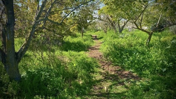
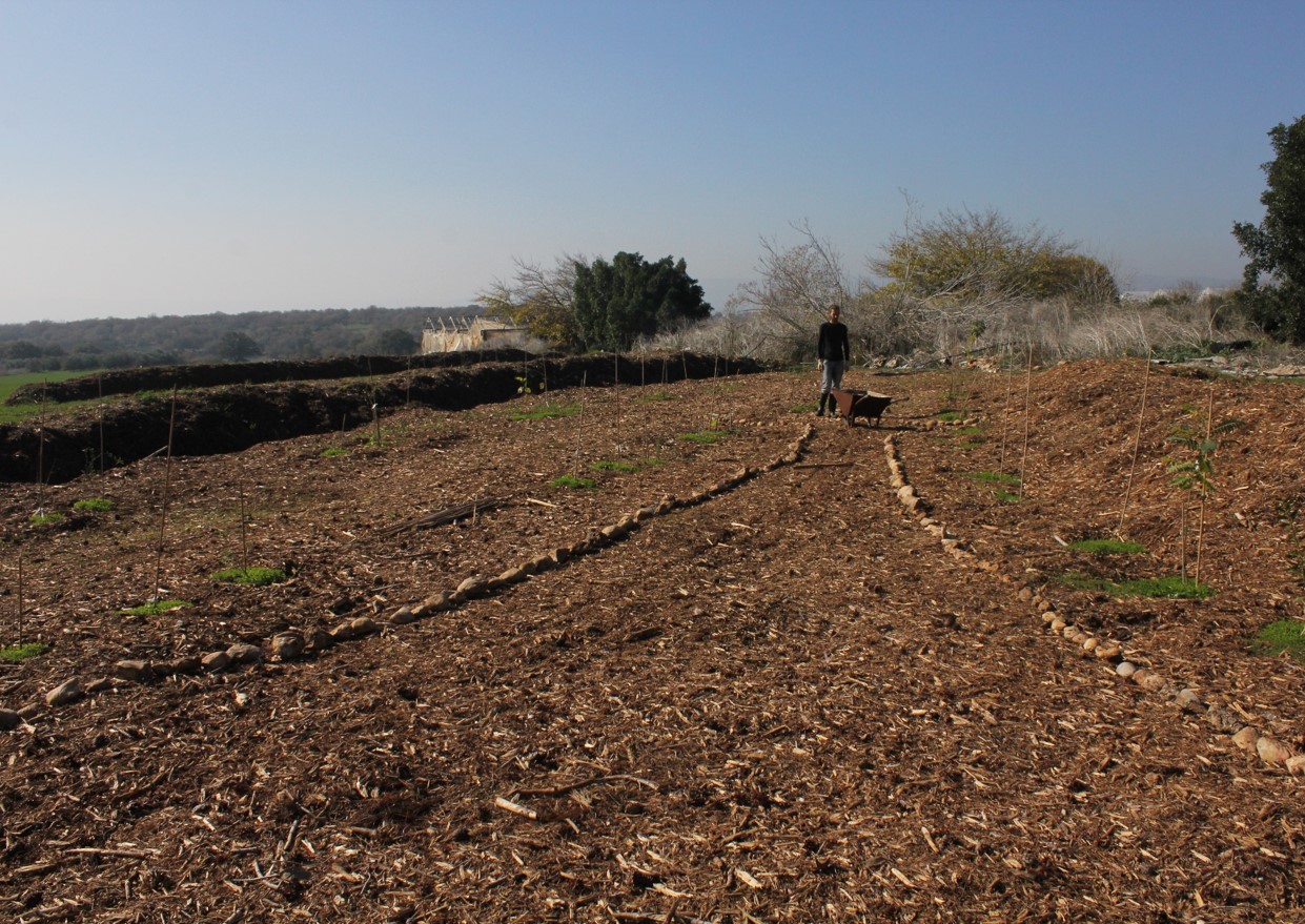
The development of a “food forest” was in response to visible soil degradation caused by years of wheat-based monoculture in Bethlehem of Galilee. The previous land use consisted of annual wheat production, tractor-powered deep ploughing, and routine use of herbicides and pesticides. Over time, these practices depleted soil organic matter, reduced microbial activity, and increased vulnerability to erosion, compaction, and moisture loss. The current food forest, covering approximately 1.5 acres (0.6 hectare), represents a transformative shift from this intensive, extractive system toward a sustainable, perennial, multi-strata agroforestry model.
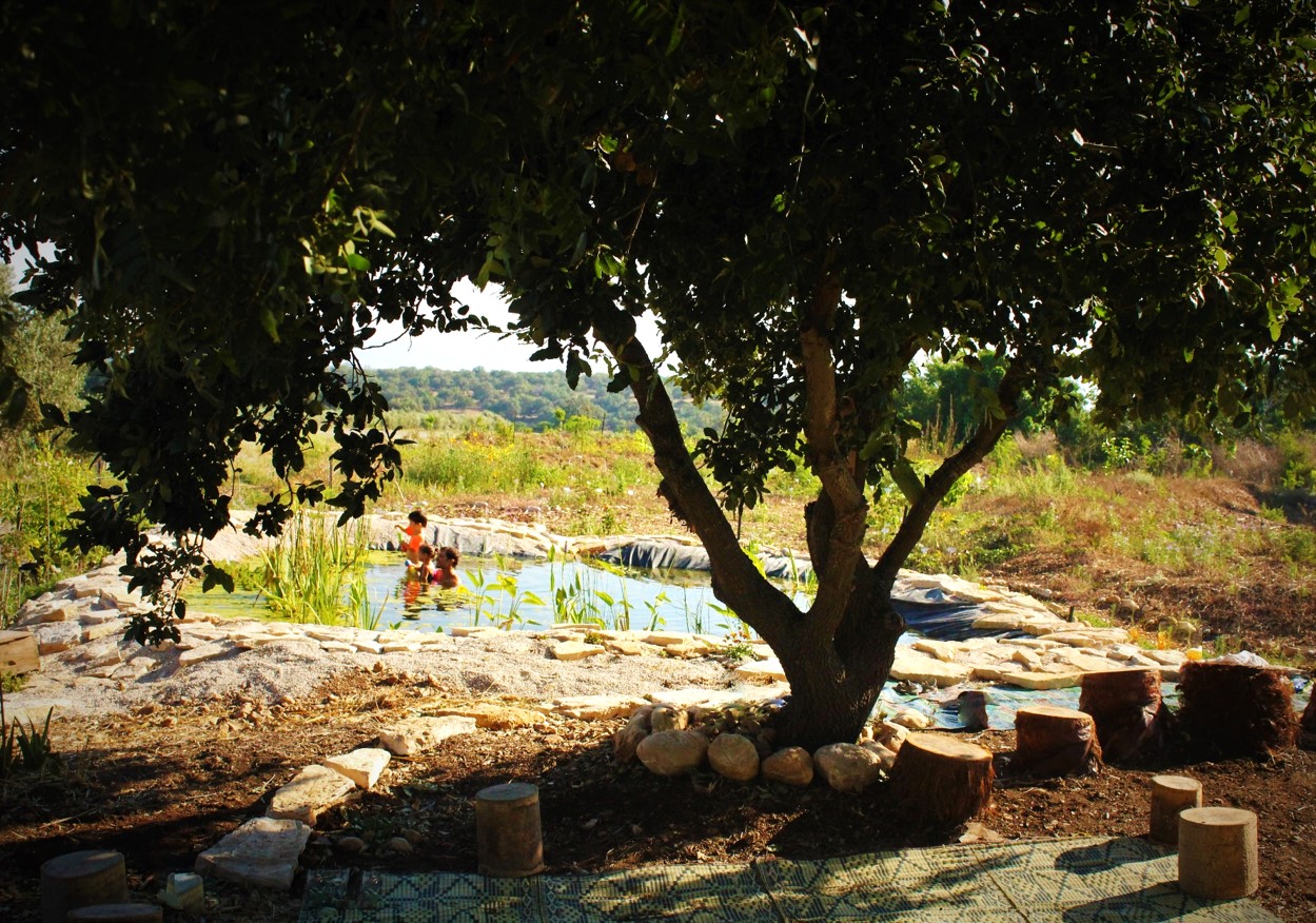
The primary purpose of this site is research and education. It is not intended to be a commercial enterprise, but to demonstrate principles and practices of sustainable land management. The income generated is not from crops but from research grants, workshops and community activities.
The site has been under continuous restoration for approximately eight years, during which it has gradually developed into a multi-layered food forest. The upper canopy includes species such as ficus, tipa, mulberry, pecan, plane trees, and nitrogen-fixing “ice-cream bean” (Inga edulis), which together generate shade, biomass, and structural diversity. The productive mid-storey contains fruit-bearing species including lemon, plum, pomegranate, avocado, and additional deciduous trees. Beneath these layers, aromatic shrubs such as lavender and rosemary provide perennial cover, habitat complexity, and year-round biomass production. A dedicated lower layer supports seasonal vegetables: carrots, radishes, turnips, lettuces and other greens, interplanted within tree alleys and cultivated using organic methods.
Production follows a diversified model typical of food forests. Tree crops currently yield modest but consistent quantities of lemons, plums, mulberries, pomegranates, and herbs, primarily for consumption by visitors, volunteers, and workers on site rather than large-scale commercial sale. The adjoining vegetable-growing area produces additional crops for small-scale marketing, providing a modest revenue stream while maintaining ecological integrity. As the system is still maturing, productive output is expected to increase over the coming years.
The project is privately managed by a couple in their thirties, who own and oversee all aspects of the site. Labour requirements were most intensive during the establishment phase of planting, mulching, earth-shaping, and infrastructure setup. As the food forest enters a more stable successional stage, labour demands have gradually decreased, with current activities centred on pruning, biomass recycling, vegetable cultivation, and occasional enrichment planting. No chemical inputs are applied at any stage.
Irrigation was originally supported by a drip system installed to establish young trees and early perennial layers. Today, irrigation needs have significantly decreased due to higher soil organic matter, increased shade, and improved microclimate regulation. Drip irrigation is now used only minimally and mainly within the annual vegetable plots, while most perennial components rely primarily on natural rainfall.
Overall, this food forest demonstrates a replicable nature-based solution for Mediterranean environments, showcasing how degraded wheat monoculture fields can be restored into resilient, biodiverse, and ecologically functional agroforestry systems. The long-term transition highlights substantial gains in soil health, water retention, and landscape diversity, while supporting small-scale production and community-oriented engagement.
2.3 รูปภาพของเทคโนโลยี
อัลบั้มสื่อบันทึก
2.5 ประเทศภูมิภาค หรือสถานที่ตั้งที่เทคโนโลยีได้นำไปใช้และได้รับการครอบคลุมโดยการประเมินนี้
ประเทศ:
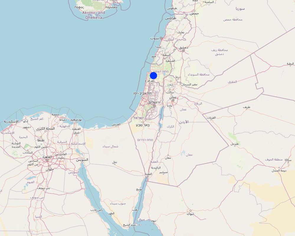
อิสราเอล
ภูมิภาค/รัฐ/จังหวัด:
Galilee
ข้อมูลจำเพาะเพิ่มเติมของสถานที่ตั้ง :
Bethlehem of Galilee
ระบุการกระจายตัวของเทคโนโลยี:
- กระจายไปอย่างสม่ำเสมอในพื้นที่
If the Technology is evenly spread over an area, specify area covered (in km2):
0.01
If precise area is not known, indicate approximate area covered:
- < 0.1 ตร.กม.(10 เฮกตาร์)
Is/are the technology site(s) located in a permanently protected area?
ไม่ใช่
Map
×2.6 วันที่การดำเนินการ
ระบุปีที่ใช้:
2017
ถ้าไม่รู้ปีที่แน่นอน ให้ระบุวันที่โดยประมาณ:
- น้อยกว่า 10 ปี (ไม่นานนี้)
2.7 คำแนะนำของเทคโนโลยี
ให้ระบุว่าเทคโนโลยีถูกแนะนำเข้ามาอย่างไร:
- ด้วยการริเริ่มของผู้ใช้ที่ดินเอง
- ในช่วงการทดลองหรือการทำวิจัย
- ทางโครงการหรือจากภายนอก
ความคิดเห็น (ประเภทของโครงการ เป็นต้น) :
The landowners developed the site as part of a holistic environmental vision and continue to refine it through ongoing learning, experimentation, and renewal. They actively initiate collaborations with research institutions in Israel and abroad to support long-term monitoring of the site and to advance the food-forest practice within a scientific and evidence-based framework.
3. การจัดประเภทของเทคโนโลยี SLM
3.1 วัตถุประสงค์หลักของเทคโนโลยี
- ลด ป้องกัน ฟื้นฟู การเสื่อมโทรมของที่ดิน
- อนุรักษ์ระบบนิเวศน์
- รักษาสภาพหรือปรับปรุงความหลากหลายทางชีวภาพ
- ปรับตัวเข้ากับการเปลี่ยนแปลงภูมิอากาศของโลก สภาพภูมิอากาศที่รุนแรงและผลกระทบ
- สร้างผลกระทบทางด้านสังคมที่เป็นประโยชน์
3.2 ประเภทของการใช้ที่ดินในปัจจุบันที่ได้นำเทคโนโลยีไปใช้
Land use mixed within the same land unit:
ใช่
Specify mixed land use (crops/ grazing/ trees):
- วนเกษตร (Agroforestry)

พื้นที่ปลูกพืช
- การปลูกพืชล้มลุกอายุปีเดียว
- การปลูกไม้ยืนต้น ไม้พุ่ม
Annual cropping - Specify crops:
- legumes and pulses - peas
- medicinal/ aromatic/ pesticidal plants and herbs
- vegetables - leafy vegetables (salads, cabbage, spinach, other)
- vegetables - root vegetables (carrots, onions, beet, other)
Tree and shrub cropping - Specify crops:
- avocado
- citrus
- figs
- pome fruits (apples, pears, quinces, etc.)
- stone fruits (peach, apricot, cherry, plum, etc)
- tree nuts (brazil nuts, pistachio, walnuts, almonds, etc.)
จำนวนของฤดูเพาะปลูกต่อปี:
- 3
ระบุ:
Up to three for the fastest growing crops
Is intercropping practiced?
ใช่
If yes, specify which crops are intercropped:
The whole farm forest embodies intercropping throughout its multi-strata structure
Is crop rotation practiced?
ใช่
ถ้าใช่ ระบุ:
Various annual crops as described above - and an adaptive succession strategy

ป่า/พื้นที่ทำไม้
- ป่า/พื้นที่ทำไม้
Tree plantation, afforestation: Specify origin and composition of species:
- การปลูกหลายพันธุ์รวมกัน
Type of tree plantation, afforestation:
- temperate continental forest plantation
- Ficus, Tipu (Tipuana tipu), Plane tree (Platanus spp.), Sissoo (Dalbergia sissoo), Ice-cream bean
Are the trees specified above deciduous or evergreen?
- mixed deciduous/ evergreen
ผลิตภัณฑ์และบริการ:
- ผลไม้และถั่ว
- ผลิตภัณฑ์อื่น ๆ จากป่า
- การอนุรักษ์ / ป้องกันธรรมชาติ
- นันทนาการ / การท่องเที่ยว
3.3 Has land use changed due to the implementation of the Technology?
Has land use changed due to the implementation of the Technology?
- Yes (Please fill out the questions below with regard to the land use before implementation of the Technology)
Land use mixed within the same land unit:
ไม่ใช่
พื้นที่ปลูกพืช
- การปลูกพืชล้มลุกอายุปีเดียว
Annual cropping - Specify crops:
- cereals - wheat (spring)
Annual cropping system:
Wheat or similar rotation with hay/pasture
Is intercropping practiced?
ไม่ใช่
Is crop rotation practiced?
ใช่
ถ้าใช่ ระบุ:
Occasionally (see above)
3.4 การใช้น้ำ
การใช้น้ำของที่ดินที่มีการใช้เทคโนโลยีอยู่:
- น้ำฝนร่วมกับการชลประทาน
แสดงความคิดเห็น:
Irrigation was originally supported by a drip system installed to establish young trees and early perennial layers. Today, irrigation needs have significantly decreased due to higher soil organic matter, increased shade, and improved microclimate regulation. Drip irrigation is now used only minimally and mainly within the annual vegetable plots, while most perennial components rely primarily on natural rainfall.
3.5 กลุ่ม SLM ที่ตรงกับเทคโนโลยีนี้
- การปลูกป่าร่วมกับพืช
- การปรับปรุงดิน / พืชคลุมดิน
- การรบกวนดินให้น้อยที่สุด
3.6 มาตรการ SLM ที่ประกอบกันเป็นเทคโนโลยี

มาตรการอนุรักษ์ด้วยวิธีพืช
- V1: ต้นไม้และพุ่มไม้คลุมดิน
- V2: หญ้าและไม้ยืนต้น

มาตรการอนุรักษ์ด้วยการจัดการ
- M1: การเปลี่ยนรูปแบบของการใช้ประโยชน์ที่ดิน
- M2: การเปลี่ยนแปลงของการจัดการหรือระดับความเข้มข้น
- M5: การควบคุมหรือการเปลี่ยนแปลงขององค์ประกอบของชนิดพันธุ์
3.7 รูปแบบหลักของการเสื่อมโทรมของที่ดินที่ได้รับการแก้ไขโดยเทคโนโลยี

การกัดกร่อนของดินโดยน้ำ
- Wt (Loss of topsoil): การสูญเสียดินชั้นบนหรือการกัดกร่อนที่ผิวดิน

การเสื่อมโทรมของดินทางด้านเคมี
- Cn (Fertility decline): ความอุดมสมบูรณ์และปริมาณอินทรียวัตถุในดินถูกทำให้ลดลงไป (ไม่ได้เกิดจากสาเหตุการกัดกร่อน)
- Cs (Salinization/alkalinization): การสะสมเกลือหรือการทำให้เป็นด่าง

การเสื่อมโทรมของดินทางด้านกายภาพ
- Pc (Compaction): การอัดแน่น
- Pi (Soil sealing)
- Ps (Subsidence of organic soils): การยุบตัวของดินอินทรีย์ การทรุดตัวของดิน

การเสื่อมโทรมของดินทางด้านชีวภาพ
- Bc (Reduction of vegetation cover): การลดลงของจำนวนพืชที่ปกคลุมดิน
- Bh (Loss of habitat): การสูญเสียแหล่งที่อยู่
- Bq (Quantity/biomass decline): การลดลงของปริมาณหรือมวลชีวภาพ
- Bs (Quality and species composition): องค์ประกอบหรือความหลากหลายทางคุณภาพและชนิดพันธุ์ลดลง
แสดงความคิดเห็น:
For this pilot, the technology primarily addresses soil degradation (chemical + physical + biological) that resulted from long-term monoculture and herbicide-based management.
3.8 การป้องกัน การลดลง หรือการฟื้นฟูความเสื่อมโทรมของที่ดิน
ระบุเป้าหมายของเทคโนโลยีกับความเสื่อมโทรมของที่ดิน:
- ลดความเสื่อมโทรมของดิน
- ฟื้นฟูบำบัดที่ดินที่เสื่อมโทรมลงอย่างมาก
4. ข้อมูลจำเพาะด้านเทคนิค กิจกรรมการนำไปปฏิบัติใช้ ปัจจัยนำเข้า และค่าใช้จ่าย
4.1 แบบแปลนทางเทคนิคของเทคโนโลยี
ข้อมูลจำเพาะด้านเทคนิค (แบบแปลนทางเทคนิคของเทคโนโลยี):
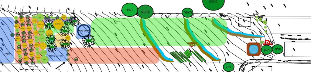
The general site plan (above) illustrates the full spatial organization of the food forest, structured into clearly defined functional zones that together create a balanced ecological and productive landscape (Note: original plan reproduced with captions in Hebrew). The outer perimeter consists of a protective tree belt designed to provide wind buffering, habitat continuity, and microclimate regulation. Inside this perimeter lies a series of densely planted clusters of mixed-species trees and support plants, forming the core forested zones of the design. These clusters contain a combination of canopy species, fruit trees, nitrogen-fixing support species, and understory elements arranged to promote ecological interactions and long-term resilience. Several open areas are intentionally integrated throughout the site, providing space for circulation, light penetration, future expansion, and community activities. The plan also includes a designated agricultural strip for annual vegetable production, strategically placed to benefit from the moderated microclimate created by the surrounding tree layers. Additional functional elements such as a compost area, shaded seating or gathering points, and access paths appear throughout the design, supporting both maintenance and educational use. Overall, the plan demonstrates a holistic integration of productive, ecological, and social spaces, emphasizing diversity, spatial layering, and regenerative land-use principles.
ผู้เขียน:
Nitzan Betzer
วันที่:
01/06/2017
ข้อมูลจำเพาะด้านเทคนิค (แบบแปลนทางเทคนิคของเทคโนโลยี):
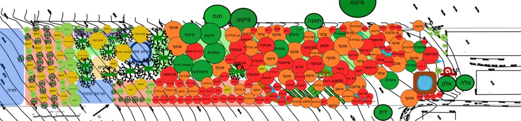
The planting plan (below) illustrates the full structural design of the food forest, showing a diverse mixture of perennial species arranged according to ecological function and spatial layout (Note: original plan reproduced with captions in Hebrew). Each color on the map represents a different botanical or functional category. The green circles indicate the major canopy and shade-providing trees that form the upper layer of the system. The red circles mark the fruit-bearing species distributed across the plot, including pomegranate, avocado, fig, loquat, mango, mulberry and others, representing the primary productive component of the mid-storey. The orange circles correspond to nitrogen-fixing trees and shrubs, strategically positioned to enrich soil fertility and support surrounding species through natural nutrient cycling. The yellow circles mark ornamental or habitat-supporting species that enhance biodiversity, microclimate regulation and ecological resilience. Together, these categories create a multi-layered mosaic in which canopy, fruit, support species and habitat elements interweave across the site. The design also includes designated open areas, compost space, perimeter rows and an agricultural strip for annual vegetables, demonstrating an intentional balance between ecological restoration, food production and functional zoning.
ผู้เขียน:
Nitzan Betzer
วันที่:
01/06/2017
4.2 ข้อมูลทั่วไปเกี่ยวกับการคำนวณปัจจัยนำเข้าและค่าใช้จ่าย
ให้ระบุว่าค่าใช้จ่ายและปัจจัยนำเข้าได้รับการคำนวณอย่างไร:
- ต่อพื้นที่ที่ใช้เทคโนโลยี
ระบุขนาดและหน่วยพื้นที่:
1.5 acres
If using a local area unit, indicate conversion factor to one hectare (e.g. 1 ha = 2.47 acres): 1 ha =:
1 acre = 0.4 hectares
ระบุสกุลเงินที่ใช้คำนวณค่าใช้จ่าย:
- USD
ระบุค่าเฉลี่ยของค่าจ้างในการจ้างแรงงานต่อวัน:
158.2
4.3 กิจกรรมเพื่อการจัดตั้ง
| กิจกรรม | Timing (season) | |
|---|---|---|
| 1. | Initial site assessment and mapping of soil condition and exposure | Late winter / early spring |
| 2. | Discontinuation of tillage and herbicide applications | Immediately prior to establishment |
| 3. | Soil preparation without deep tillage (light loosening, mulching base layer) | Early spring |
| 4. | Planting of trees in primary layout (skeleton layer) | Spring |
| 5. | Planting of shrubs and understory companion species | Late spring / early summer |
| 6. | Installation of organic mulch cover to protect soil and retain moisture | After planting (early summer) |
| 7. | Enrichment planting / filling gaps with additional groundcover species | Late summer / following spring |
| 8. | Protection of young trees/shrubs if needed (guards, shading, temporary watering) | First growing season |
| 9. | Establishment of biomass cycling (chop-and-drop, composting on-site) | After vegetation takes root |
| 10. | Transition into maintenance phase (reduced intervention, natural succession) | Once canopy begins forming |
4.4 ค่าใช้จ่ายของปัจจัยนำเข้าที่จำเป็นสำหรับการจัดตั้ง
| ปัจจัยนำเข้า | หน่วย | ปริมาณ | ค่าใช้จ่ายต่อหน่วย | ค่าใช้จ่ายทั้งหมดต่อปัจจัยนำเข้า | %ของค่าใช้จ่ายที่ก่อให้เกิดขึ้นโดยผู้ใช้ที่ดิน | |
|---|---|---|---|---|---|---|
| แรงงาน | Manual labour | Person-days | 139.0 | 158.2 | 21989.8 | 100.0 |
| อุปกรณ์ | Tools and maintenance equipment | 1.0 | 5000.0 | 5000.0 | 100.0 | |
| อุปกรณ์ | Tractor (for construction) | 1.0 | 7200.0 | 7200.0 | 100.0 | |
| วัสดุด้านพืช | Seedlings, cuttings, and seeds | 1.0 | 14000.0 | 14000.0 | 100.0 | |
| ปุ๋ยและสารฆ่า/ยับยั้งการเจริญเติบโตของสิ่งมีชีวิต (ไบโอไซด์) | Compost | 1.0 | 10500.0 | 10500.0 | 100.0 | |
| วัสดุสำหรับก่อสร้าง | Irrigation system | 1.0 | 14500.0 | 14500.0 | 100.0 | |
| วัสดุสำหรับก่อสร้าง | Pruned biomass mulch | 1.0 | 6500.0 | 6500.0 | 100.0 | |
| ค่าใช้จ่ายทั้งหมดของการจัดตั้งเทคโนโลยี | 79689.8 | |||||
| Total costs for establishment of the Technology in USD | 79689.8 | |||||
ถ้าผู้ใช้ที่ดินรับภาระน้อยกว่า 100% ของค่าใช้จ่าย ให้ระบุว่าใครเป็นผู้รับผิดชอบส่วนที่เหลือ:
Land user bore all costs: but note the primary purpose of this site is research and education. It is not intended to be a commercial enterprise, but to demonstrate principles and practices of sustainable land management. The income generated is not from crops but from research grants, workshops and community activities.
แสดงความคิดเห็น:
No chemical fertilizers or pesticides are used; fertilization is based solely on compost
4.5 การบำรุงรักษาสภาพหรือกิจกรรมที่เกิดขึ้นเป็นประจำ
| กิจกรรม | ช่วงระยะเวลา/ความถี่ | |
|---|---|---|
| 1. | Mulching with organic biomass (leaf litter, pruning residues, woodchips, etc.) | 2–3 times per year, mainly after rainy season and mid-summer |
| 2. | Selective pruning of trees and shrubs to maintain structure and light balance | Annually / as needed (late winter or autumn) |
| 3. | Enrichment planting and succession planting of understorey species | Seasonally, as ecosystem matures or gaps appear |
| 4. | Weeding by ecological suppression (groundcover strengthening) rather than removal | Continuous, low-intensity maintenance |
| 5. | Soil moisture conservation (biomass renewal / occasional supportive watering in drought years) | Seasonally during dry periods (as needed) |
| 6. | Monitoring soil condition and vegetation health | Ongoing, at least once per season |
| 7. | Replacement of failed or weak young plants | Annually during early growth seasons |
| 8. | Maintenance of biodiversity guilds / companion planting structure | Continuous, adaptive to natural succession |
4.6 ค่าใช้จ่ายของปัจจัยนำเข้าและกิจกรรมที่เกิดขึ้นเป็นประจำที่ต้องการการบำรุงรักษา (ต่อปี)
| ปัจจัยนำเข้า | หน่วย | ปริมาณ | ค่าใช้จ่ายต่อหน่วย | ค่าใช้จ่ายทั้งหมดต่อปัจจัยนำเข้า | %ของค่าใช้จ่ายที่ก่อให้เกิดขึ้นโดยผู้ใช้ที่ดิน | |
|---|---|---|---|---|---|---|
| แรงงาน | Manual labour | Person-days | 110.0 | 158.2 | 17402.0 | 100.0 |
| อุปกรณ์ | Equipment renewal and maintenance | 1.0 | 5000.0 | 5000.0 | 100.0 | |
| วัสดุด้านพืช | Cuttings and seeds | 1.0 | 4000.0 | 4000.0 | 100.0 | |
| อื่น ๆ | Water bills | 1.0 | 5500.0 | 5500.0 | 100.0 | |
| อื่น ๆ | Products selling kits | 1.0 | 2000.0 | 2000.0 | 100.0 | |
| ค่าใช้จ่ายทั้งหมดของการบำรุงรักษาสภาพเทคโนโลยี | 33902.0 | |||||
| Total costs for maintenance of the Technology in USD | 33902.0 | |||||
แสดงความคิดเห็น:
The establishment costs refer to the initial food forest area of approximately 1.5 acres, while the annual maintenance costs refer to the forest in its current state, covering about 3 acres. Land user bore all costs: but note that the primary purpose of this site is research and education. It is not intended to be a commercial enterprise, but to demonstrate principles and practices of sustainable land management. The income generated is not from crops but from research grants, workshops and community activities.
4.7 ปัจจัยสำคัญที่สุดที่มีผลกระทบต่อค่าใช้จ่าย
ปัจจัยสำคัญที่สุดที่มีผลกระทบต่อค่าใช้จ่ายต่างๆ:
The most significant cost factor, both during establishment and ongoing maintenance, is labour. All work is carried out manually using hand tools, and apart from the initial establishment phase, no heavy machinery is used
5. สิ่งแวดล้อมทางธรรมชาติและของมนุษย์
5.1 ภูมิอากาศ
ฝนประจำปี
- < 250 ม.ม.
- 251-500 ม.ม.
- 501-750 ม.ม.
- 751-1,000 ม.ม.
- 1,001-1,500 ม.ม.
- 1,501-2,000 ม.ม.
- 2,001-3,000 ม.ม.
- 3,001-4,000 ม.ม.
- > 4,000 ม.ม.
ระบุชื่อของสถานีตรวดวัดอากาศที่ใช้อ้างอิงคือ:
The climatic information for the food forest site was obtained from two sources: official data provided by the Israel Meteorological Service (IMS) and on-site measurements collected through a dedicated rain gauge installed as part of the research infrastructure. Together, these sources provide accurate local rainfall and climate monitoring for the plot.
เขตภูมิอากาศเกษตร
- กึ่งชุ่มชื้น
5.2 สภาพภูมิประเทศ
ค่าเฉลี่ยความลาดชัน:
- ราบเรียบ (0-2%)
- ลาดที่ไม่ชัน (3-5%)
- ปานกลาง (6-10%)
- เป็นลูกคลื่น (11-15%)
- เป็นเนิน (16-30%)
- ชัน (31-60%)
- ชันมาก (>60%)
ธรณีสัณฐาน:
- ที่ราบสูง/ที่ราบ
- สันเขา
- ไหล่เขา
- ไหล่เนินเขา
- ตีนเนิน
- หุบเขา
ระดับความสูง:
- 0-100 เมตร
- 101-500 เมตร
- 501-1,000 เมตร
- 1,001-1,500 เมตร
- 1,501-2,000 เมตร
- 2,001-2,500 เมตร
- 2,501-3,000 เมตร
- 3,001-4,000 เมตร
- > 4,000 เมตร
ให้ระบุถ้าเทคโนโลยีได้ถูกนำไปใช้:
- ไม่เกี่ยวข้อง
5.3 ดิน
ค่าเฉลี่ยความลึกของดิน:
- ตื้นมาก (0-20 ซ.ม.)
- ตื้น (21-50 ซ.ม.)
- ลึกปานกลาง (51-80 ซ.ม.)
- ลึก (81-120 ซ.ม.)
- ลึกมาก (>120 ซ.ม.)
เนื้อดิน (ดินชั้นบน):
- ปานกลาง (ดินร่วน ทรายแป้ง)
เนื้อดินล่าง (> 20 ซ.ม.ต่ำจากผิวดิน):
- ปานกลาง (ดินร่วน ทรายแป้ง)
อินทรียวัตถุในดิน:
- ต่ำ (<1%)
5.4 ความเป็นประโยชน์และคุณภาพของน้ำ
ระดับน้ำใต้ดิน:
5-50 เมตร
น้ำไหลบ่าที่ผิวดิน:
ไม่ดีหรือไม่มีเลย
คุณภาพน้ำ (ที่ยังไม่ได้บำบัด):
เป็นน้ำใช้เพื่อการเกษตรเท่านั้น (การชลประทาน)
Water quality refers to:
both ground and surface water
ความเค็มของน้ำเป็นปัญหาหรือไม่:
ไม่ใช่
กำลังเกิดน้ำท่วมในพื้นที่หรือไม่:
ไม่ใช่
5.5 ความหลากหลายทางชีวภาพ
ความหลากหลายทางชนิดพันธุ์:
- ต่ำ
ความหลากหลายของแหล่งที่อยู่:
- ต่ำ
ความคิดเห็นและข้อมูลจำเพาะเพิ่มเติมของความหลากหลายทางชีวภาพ:
Both species diversity and habitat diversity have transformed due to the establishment of the food forest, and are now both high. This is a very agrobiodiverse system.
5.6 ลักษณะของผู้ใช้ที่ดินที่นำเทคโนโลยีไปปฏิบัติใช้
อยู่กับที่หรือเร่ร่อน:
- อยู่กับที่
แนวทางการตลาดของระบบการผลิต:
- เพื่อการยังชีพ (หาเลี้ยงตนเอง)
รายได้ที่มาจากนอกฟาร์ม:
- > 50% ของรายได้ทั้งหมด
ระดับของความมั่งคั่งโดยเปรียบเทียบ:
- พอมีพอกิน
เป็นรายบุคคล/ครัวเรือน:
- เป็นรายบุคคล/ครัวเรือน
ระดับของการใช้เครื่องจักรกล:
- งานที่ใช้แรงกาย
เพศ:
- หญิง
- ชาย
อายุของผู้ใช้ที่ดิน:
- วัยกลางคน
5.7 Average area of land used by land users applying the Technology
- < 0.5 เฮกตาร์
- 0.5-1 เฮกตาร์
- 1-2 เฮกตาร์
- 2-5 เฮกตาร์
- 5-15 เฮกตาร์
- 15-50 เฮกตาร์
- 50-100 เฮกตาร์
- 100-500 เฮกตาร์
- 500-1,000 เฮกตาร์
- 1,000-10,000 เฮกตาร์
- >10,000 เฮกตาร์
พิจารณาว่าเป็นขนาดเล็ก กลาง หรือขนาดใหญ่ (ซึ่งอ้างอิงถึงบริบทระดับท้องถิ่น):
- ขนาดเล็ก
แสดงความคิดเห็น:
The land user manages approximately 2–5 hectares in total, of which a portion is undergoing transition into a food forest system; this is considered small-scale in the local agricultural context
5.8 กรรมสิทธิ์ในที่ดิน สิทธิในการใช้ที่ดินและสิทธิในการใช้น้ำ
กรรมสิทธิ์ในที่ดิน:
- รายบุคคล ได้รับสิทธิครอบครอง
สิทธิในการใช้ที่ดิน:
- รายบุคคล
สิทธิในการใช้น้ำ:
- รายบุคคล
Are land use rights based on a traditional legal system?
ไม่ใช่
5.9 การเข้าถึงบริการและโครงสร้างพื้นฐาน
สุขภาพ:
- จน
- ปานกลาง
- ดี
การศึกษา:
- จน
- ปานกลาง
- ดี
ความช่วยเหลือทางด้านเทคนิค:
- จน
- ปานกลาง
- ดี
การจ้างงาน (เช่น ภายนอกฟาร์ม):
- จน
- ปานกลาง
- ดี
ตลาด:
- จน
- ปานกลาง
- ดี
พลังงาน:
- จน
- ปานกลาง
- ดี
ถนนและการขนส่ง:
- จน
- ปานกลาง
- ดี
น้ำดื่มและการสุขาภิบาล:
- จน
- ปานกลาง
- ดี
บริการด้านการเงิน:
- จน
- ปานกลาง
- ดี
6. ผลกระทบและสรุปคำบอกกล่าว
6.1 ผลกระทบในพื้นที่ดำเนินการ (On-site) จากการใช้เทคโนโลยี
ผลกระทบทางด้านเศรษฐกิจและสังคม
รายได้และค่าใช้จ่าย
ค่าใช่จ่ายของปัจจัยการผลิตทางการเกษตร
แสดงความคิดเห็น/ระบุ:
Agricultural input expenses are very limited in this system. Since the site operates as a food forest rather than a conventional agricultural plot, nearly no external inputs are purchased. The management relies on ecological processes, on-site biomass, mulching, and manual care. Inputs are therefore minimal and do not reflect commercial-scale agricultural expenditure.
ความหลากหลายของแหล่งผลิตรายได้
แสดงความคิดเห็น/ระบุ:
The plot was originally managed as a monoculture field that depended economically on agricultural production. Today, the food forest operates on a completely different model: its income is derived primarily from research activities, educational programs, workshops, and community engagement. Economic sustainability is no longer based on agricultural yield, as crop production is not the financial foundation of the site anymore.
ผลกระทบด้านสังคมวัฒนธรรมอื่น ๆ
โอกาสทางวัฒนธรรม
แสดงความคิดเห็น/ระบุ:
The food forest contributes significantly to cultural opportunities in the area. It serves as a community-oriented space that hosts educational events, workshops, volunteer activities, and gatherings focused on sustainability and ecological awareness. The site fosters cultural exchange, strengthens community cohesion, and provides a shared environment for learning, creativity, and connection to nature.
สถาบันของชุมชน
แสดงความคิดเห็น/ระบุ:
Note: The food forest strengthens community institutions by collaborating with local educational programs, volunteer groups, and research initiatives. It provides a stable platform for schools, community organizations, and environmental groups to conduct activities, thereby reinforcing their role in community life and expanding their capacity for outreach and engagement.
SLM หรือความรู้เรื่องความเสื่อมโทรมของที่ดิน
แสดงความคิดเห็น/ระบุ:
The food forest contributes to improved SLM and land-degradation knowledge by serving as a living demonstration site where restoration practices can be observed, tested, and monitored over time. It provides real-world evidence on soil recovery, biodiversity enhancement, and regenerative management, supporting both scientific research and practical learning for land users, students, and professionals.
ผลกระทบด้านนิเวศวิทยา
วัฐจักรน้ำหรือน้ำบ่า
น้ำไหลบ่าที่ผิวดิน
แสดงความคิดเห็น/ระบุ:
The food forest reduces surface runoff through continuous vegetative cover, increased soil organic matter, and improved infiltration. The multi-layered perennial structure slows water movement, stabilizes the soil, and enhances water absorption, thereby decreasing erosion risk and minimizing overland flow during rainfall events.
การระเหย
แสดงความคิดเห็น/ระบุ:
The food forest reduces soil surface evaporation through dense vegetative cover, shading from the multi-layered canopy, and increased soil organic matter. Mulching and groundcover plants further protect the soil surface, lowering temperatures at ground level and limiting direct exposure to sun and wind, which significantly decreases soil surface evaporative water loss.
ดิน
ความชื้นในดิน
แสดงความคิดเห็น/ระบุ:
The food forest increases soil moisture by improving infiltration, enhancing organic matter content, and maintaining continuous groundcover. The multi-layered canopy moderates temperature and reduces evaporation, while mulch and living groundcovers retain water in the upper soil layers. Together, these features create a cooler, moister soil environment that supports long-term ecological function.
สิ่งปกคลุมดิน
แสดงความคิดเห็น/ระบุ:
The food forest improves ground cover through the establishment of multi-layered perennial vegetation, including trees, shrubs, and living groundcovers. Mulch application and natural leaf litter further protect the soil surface, ensuring year-round coverage that reduces erosion, enhances soil health, and supports ecological stability.
การเกิดแผ่นแข็งที่ผิวดิน /การเกิดชั้นดาน
แสดงความคิดเห็น/ระบุ:
The food forest reduces soil crusting and surface sealing by increasing organic matter, maintaining continuous vegetative cover, and enhancing biological activity in the upper soil layers. Leaf litter, mulch, and root penetration prevent the formation of hard surface layers, while improved soil structure allows better infiltration and aeration, minimizing the risk of crust development.
การหมุนเวียนและการเติมของธาตุอาหาร
แสดงความคิดเห็น/ระบุ:
The food forest enhances nutrient cycling and soil nutrient recharge through continuous biomass production, leaf litter accumulation, and root turnover. Nitrogen-fixing species, mulch, and on-site organic matter decomposition replenish soil nutrients naturally, while diverse plant strata promote active microbial communities that accelerate nutrient transformation and availability.
อินทรียวัตถุในดิน/ต่ำกว่าดินชั้น C
แสดงความคิดเห็น/ระบุ:
The food forest increases soil organic matter and below-ground carbon through continuous inputs of leaf litter, root biomass, and decomposing mulch. The perennial, multi-layered vegetation system supports sustained carbon incorporation into the soil, while reduced disturbance and enhanced microbial activity further promote long-term carbon storage and soil organic matter accumulation.
ความหลากหลายทางชีวภาพของพืชและสัตว์
การปกคลุมด้วยพืช
แสดงความคิดเห็น/ระบุ:
The food forest substantially increases vegetation cover by establishing multiple perennial layers - canopy trees, mid-storey species, shrubs, and groundcovers - that provide continuous, year-round biomass. This expanded plant cover protects the soil, supports ecological processes, and creates a more resilient and biodiverse landscape compared to the former monoculture field.
มวลชีวภาพ/เหนือดินชั้น C
แสดงความคิดเห็น/ระบุ:
The food forest increases above-ground biomass and carbon storage through the establishment of diverse perennial vegetation, including canopy trees, fruit species, shrubs, and herbaceous layers. As these plants grow, they accumulate significant living biomass, sequester carbon, and contribute to long-term ecological stability through continuous organic matter production and structural complexity.
ความหลากหลายทางชีวภาพของพืช
แสดงความคิดเห็น/ระบุ:
The food forest greatly increases plant diversity by integrating a wide range of tree species, fruit trees, nitrogen-fixing plants, shrubs, herbs, and groundcovers. This multi-strata design replaces the former single-crop system with a complex, species-rich community that enhances ecological resilience, supports wildlife, and promotes functional biodiversity across the site.
ความหลากหลายของสัตว์
แสดงความคิดเห็น/ระบุ:
The food forest increases habitat diversity by creating a multi-layered structure that supports varied ecological niches. The combination of canopy trees, understory species, shrubs, groundcovers, open areas, and water features provides habitats for a wide range of insects, birds, and small wildlife. This structural and functional diversity replaces the uniform habitat of the former monoculture and greatly enhances overall ecosystem complexity.
ลดความเสี่ยงของภัยพิบัติ
การปล่อยคาร์บอนและก๊าซเรือนกระจก
แสดงความคิดเห็น/ระบุ:
The food forest helps reduce carbon and greenhouse gas emissions by minimizing external inputs, eliminating chemical fertilizers, and avoiding soil disturbance that would otherwise release stored carbon. The perennial vegetation continuously sequesters carbon in both biomass and soil, while the system’s low-energy, regenerative management reduces emissions associated with conventional agricultural practices.
Specify assessment of on-site impacts (measurements):
The assessment of on-site impacts combines both social-cultural learning processes and quantitative biophysical measurements. On the social, cultural, and economic side, the site hosts workshops, guided learning sessions, and community activities designed to understand the meaning, role, and value of the food forest for local stakeholders. These engagements provide qualitative insights into cultural benefits, community strengthening, and the educational function of the place. For the more tangible biophysical parameters – soil health, vegetation condition, biodiversity, and ecological recovery – the monitoring relies on analytical laboratory tests and systematic long-term sampling. Soil samples collected at different stages of the establishment process were analyzed for organic matter, nutrients, structure, and biological activity, providing a clear picture of soil improvement over time. In addition, the site is monitored through remote-sensing-based indicators developed in collaboration with the University of Haifa, which track temporal changes in vegetation cover, biomass, soil moisture proxies, and overall ecological function. Together, these qualitative and quantitative assessments offer a comprehensive understanding of the site’s development, documenting both the ecological restoration underway and the parallel social and educational impacts generated by the food forest.
6.2 ผลกระทบนอกพื้นที่ดำเนินการ (Off-site) จากการใช้เทคโนโลยี
ผลกระทบของก๊าซเรือนกระจก
แสดงความคิดเห็น/ระบุ:
Using IPCC Tier-1 methods (2006 Guidelines with the 2019 Refinement), we estimate annual removals from (i) mineral soil organic carbon (SOC) gains after conversion from tilled wheat to multistrata agroforestry, and (ii) incremental woody biomass growth. Mediterranean evidence suggests SOC increases on managed woody systems of ~0.2–1.0 t C ha⁻¹ yr⁻¹, while biomass increments in multistrata/silvo-arable agroforestry typically add ~0.8–2.5 t C ha⁻¹ yr⁻¹ in the establishment decades; together this yields ~1.0–3.5 t C ha⁻¹ yr⁻¹, i.e., ≈ 3.7–13 tCO₂e ha⁻¹ yr⁻¹ (3.67 conversion). For reporting we adopt the conservative lower bound until our paired soil cores (baseline vs. years 2/5/8) and tree allometry—supported by Sentinel-2 time-series—finish quantifying site-specific change. Sources: IPCC 2006/2019 AFOLU guidance; AR6 WGIII (AFOLU); Mediterranean meta-analyses of SOC/biomass in woody systems and agroforestry.
Specify assessment of off-site impacts (measurements):
Off-site impacts were assessed through a combination of qualitative and quantitative indicators that capture how the food-forest system influences the surrounding landscape and community beyond the plot boundaries. Hydrological effects were inferred from reduced surface runoff and improved infiltration within the site, which collectively lower downstream sedimentation and erosion risks; these implications were evaluated using rainfall records, soil-moisture trends, and comparison of runoff behavior between the restored area and adjacent conventionally managed fields. Vegetation development and canopy expansion – monitored through Sentinel-2 time-series and UAV imagery – provide additional evidence of landscape-scale improvements such as enhanced microclimatic buffering and habitat connectivity. Social and cultural off-site impacts were evaluated through participation in workshops, educational programs, and community events, which extend ecological knowledge and stewardship beyond the site itself. Together, these measurements and observations offer a coherent picture of how the food forest contributes to broader environmental and community benefits outside its physical boundaries.
6.3 การเผชิญและความตอบสนองของเทคโนโลยีต่อการเปลี่ยนแปลงสภาพภูมิอากาศที่ค่อยเป็นค่อยไป และสภาพรุนแรงของภูมิอากาศ / ภัยพิบัติ (ที่รับรู้ได้โดยผู้ใช้ที่ดิน)
การเปลี่ยนแปลงสภาพภูมิอากาศที่ค่อยเป็นค่อยไป
การเปลี่ยนแปลงสภาพภูมิอากาศที่ค่อยเป็นค่อยไป
| ฤดู | increase or decrease | เทคโนโลยีมีวิธีการรับมืออย่างไร | |
|---|---|---|---|
| อุณหภูมิประจำปี | เพิ่มขึ้น | ปานกลาง | |
| ฝนประจำปี | ลดลง | ดี |
สภาพรุนแรงของภูมิอากาศ (ภัยพิบัติ)
ภัยพิบัติทางอุตุนิยมวิทยา
| เทคโนโลยีมีวิธีการรับมืออย่างไร | |
|---|---|
| พายุฝนประจำท้องถิ่น | ปานกลาง |
ภัยพิบัติจากสภาพภูมิอากาศ
| เทคโนโลยีมีวิธีการรับมืออย่างไร | |
|---|---|
| คลื่นความร้อน | ดี |
| ภัยจากฝนแล้ง | ดี |
6.4 การวิเคราะห์ค่าใช้จ่ายและผลประโยชน์ที่ได้รับ
ผลประโยชน์ที่ได้รับเปรียบเทียบกับค่าใช้จ่ายในการจัดตั้งเป็นอย่างไร (จากมุมมองของผู้ใช้ที่ดิน)
ผลตอบแทนระยะสั้น:
ด้านลบเล็กน้อย
ผลตอบแทนระยะยาว:
ด้านบวก
ผลประโยชน์ที่ได้รับเปรียบเทียบกับค่าใช้จ่ายในการบำรุงรักษาหรือต้นทุนที่เกิดขึ้นซ้ำอีก เป็นอย่างไร (จากมุมมองของผู้ใช้ที่ดิน)
ผลตอบแทนระยะสั้น:
เป็นกลางหรือสมดุล
ผลตอบแทนระยะยาว:
ด้านบวก
แสดงความคิดเห็น:
The slightly negative short-term balance does not reflect external subsidies but rather the intentional design and purpose of the site. The food forest is not a commercial enterprise and was never intended to generate profit from agricultural production. Its primary function is research, education, and community engagement, and therefore its revenues come from workshops, collaborations, and research grants rather than crop sales. The short-term financial deficit simply reflects the fact that the landowners invest in a long-term ecological and educational project whose value is measured in environmental and social outcomes rather than immediate economic returns. It should not be interpreted as dependence on agricultural subsidies or market-based support.
6.5 การปรับตัวของเทคโนโลยี
- ครั้งเดียวหรือเป็นการทดลอง
ถ้ามีข้อมูลให้บอกปริมาณด้วย (จำนวนของครัวเรือนหรือครอบคลุมพื้นที่):
One household: 1.5 acres
Of all those who have adopted the Technology, how many did so spontaneously, i.e. without receiving any material incentives/ payments?
- 0-10%
6.6 การปรับตัว
เทคโนโลยีได้รับการปรับเปลี่ยนเมื่อเร็วๆนี้ เพื่อให้ปรับตัวเข้ากับสภาพที่กำลังเปลี่ยนแปลงหรือไม่:
ใช่
ถ้าตอบว่าใช่ ให้ระบุว่าเงื่อนไขการเปลี่ยนแปลงใดที่ถูกปรับตัว:
- การเปลี่ยนแปลงแบบค่อยเป็นค่อยไปและสภาพรุนแรงของภูมิอากาศ
ให้ระบุการปรับตัวของเทคโนโลยี (การออกแบบ วัสดุหรือชนิดพันธุ์ เป็นต้น):
The design and composition of the food forest are continuously adapted as the system matures and as new insights emerge from ongoing learning by the landowners and collaborating researchers. Species selection, spatial arrangement, and management practices have been refined over time in response to observed ecological dynamics - such as canopy development, soil improvement, microclimatic changes, and species performance. Additional trees, shrubs, and groundcovers have been introduced to enhance diversity, strengthen ecological functions, and address emerging needs such as shade regulation, soil enrichment, or habitat creation. This adaptive approach reflects the core principle of the technology: the food forest is a living system that evolves through observation, experimentation, and evidence-based adjustments informed by both practical experience and scientific collaboration.
6.7 จุดแข็ง / ข้อได้เปรียบ / โอกาสของเทคโนโลยี
| จุดแข็ง / ข้อได้เปรียบ / โอกาสในทัศนคติของผู้ใช้ที่ดิน |
|---|
| Restores soil fertility and structure without relying on chemicals and reduces weed pressure naturally through permanent groundcover |
| Improves moisture retention and reduces drought stress over time and supports biodiversity and creates a healthier farm ecosystem |
| Transformational: turns degraded land into a productive long-term asset |
| จุดแข็ง / ข้อได้เปรียบ / โอกาสในทัศนคติของผู้รวบรวมหรือวิทยากรหลัก |
|---|
| Demonstrates a replicable nature-based solution for restoring degraded agricultural soils in Mediterranean climates |
| Increases soil organic matter and biological activity, improving long-term soil function and carbon sequestration |
| Serves as a living demonstration site with high educational and upscaling potential for regenerative farming in the region |
6.8 จุดอ่อน / ข้อเสียเปรียบ / ความเสี่ยงของเทคโนโลยีและวิธีการแก้ไข
| จุดอ่อน / ข้อเสียเปรียบ / ความเสี่ยงในทัศนคติของผู้ใช้ที่ดิน | มีวิธีการแก้ไขได้อย่างไร |
|---|---|
| Slow establishment phase before benefits become visible | Patience + phased planting; choose fast-growing pioneer species to accelerate canopy formation |
| Requires knowledge and ecological management skills | Ongoing guidance from experts / capacity building / training |
| Young plants vulnerable to drought during first summers | Supplemental irrigation in the first years and thicker mulching to reduce evaporation |
| จุดอ่อน / ข้อเสียเปรียบ / ความเสี่ยงในทัศนคติของผู้รวบรวมหรือวิทยากรหลัก | มีวิธีการแก้ไขได้อย่างไร |
|---|---|
| Long ecological recovery timeline before system reaches full functionality | Use succession planning and pioneer/perennial nurse species to accelerate canopy closure and soil regeneration |
| Success depends on appropriate species selection for local microclimate and soil | Improve site-specific design using adaptive planting trials, monitoring, and locally adapted cultivars |
| Knowledge-intensive management compared to conventional systems | Provide technical training, extension support, and farmer-to-farmer learning |
| Restoration outcomes may vary with drought years and extreme heat events | Increase biomass cover, soil shading, and water retention strategies in early establishment years |
7. การอ้างอิงและการเชื่อมต่อ
7.1 วิธีการและแหล่งข้อมูล
- ไปเยี่ยมชมภาคสนาม การสำรวจพื้นที่ภาคสนาม
Field visits and surveys were conducted once every season on-site with the primary land user (one key informant), supplemented by technical assessments from the research team
- การสัมภาษณ์กับผู้ใช้ที่ดิน
One-on-one interviews were conducted with the primary land user (one key informant) at least once a year, focusing on management decisions, perceived benefits and challenges, and changes observed since the start of the transition
- การสัมภาษณ์ผู้เชี่ยวชาญด้าน SLM หรือผู้ชำนาญ
The expert input was provided by specialists involved in the University of Haifa restoration pilot
- การเก็บรวบรวมมาจากรายงานและเอกสารที่มีอยู่
7.2 การอ้างอิงถึงสิ่งตีพิมพ์
หัวข้อ, ผู้เขียน, ปี, หมายเลข ISBN:
Zbedat, G., & Brook, A. (2025). Land Restoration Effectiveness Assessed by Satellite-Based Remote Sensing Technologies as A New Monitoring Approach. The International Archives of the Photogrammetry, Remote Sensing and Spatial Information Sciences, 48, 149-155.
ชื่อเรื่อง ผู้เขียน ปี ISBN:
Google Scholar
หัวข้อ, ผู้เขียน, ปี, หมายเลข ISBN:
T. A. Cohen, A. Brook and G. Zbedat, "Long-Term Land Restoration Assessment Using Remote Sensing in Mediterranean Ecosystems," 2024 IEEE International Workshop on Metrology for Agriculture and Forestry (MetroAgriFor), Padua, Italy, 2024, pp. 179-183, doi: 10.1109/MetroAgriFor63043.2024.10948855.
ชื่อเรื่อง ผู้เขียน ปี ISBN:
Google Scholar
7.3 Links to relevant online information
ชื่อเรื่องหรือคำอธิบาย:
React4Med site
URL:
https://react4med.eu
ชื่อเรื่องหรือคำอธิบาย:
Bethlehem of Galilee Food Forest Collection
URL:
https://haifa.primo.exlibrisgroup.com/discovery/collectionDiscovery?vid=972HAI_MAIN:HAU&inst=972HAI_MAIN&collectionId=81263109080002791
ลิงก์และโมดูล
ขยายทั้งหมด ย่อทั้งหมดลิงก์
ไม่มีลิงก์
โมดูล
ไม่มีโมดูล