Riparian buffer strips [สโลวีเนีย]
- ผู้สร้างสรรค์:
- การอัพเดท:
- ผู้รวบรวม: Gregor Kramberger
- ผู้เรียบเรียง: Tamara Korošec
- ผู้ตรวจสอบ: William Critchley, Rima Mekdaschi Studer
Varovalni pasovi ob vodotokih
technologies_6246 - สโลวีเนีย
ดูส่วนย่อย
ขยายทั้งหมด ย่อทั้งหมด1. ข้อมูลทั่วไป
1.2 รายละเอียดที่ติดต่อได้ของผู้รวบรวมและองค์กรที่เกี่ยวข้องในการประเมินและการจัดเตรียมทำเอกสารของเทคโนโลยี
ผู้เชี่ยวชาญ SLM:
ผู้เชี่ยวชาญ SLM:
Horvat Timotej
Chamber of Agriculture and Forestry of Slovenia (KGZS) – Institute of Agriculture and Forestry Maribor Slovenia
สโลวีเนีย
co-compiler:
Ropič Andrej
Farmer
สโลวีเนีย
ผู้เชี่ยวชาญ SLM:
Kep Tina
Chamber of Agriculture and Forestry of Slovenia (KGZS) – Institute of Agriculture and Forestry Maribor Slovenia
สโลวีเนีย
ชื่อของโครงการซึ่งอำนวยความสะดวกในการทำเอกสารหรือการประเมินเทคโนโลยี (ถ้าเกี่ยวข้อง)
OPtimal strategies to retAIN and re-use water and nutrients in small agricultural catchments across different soil-climatic regions in Europe (OPTAIN)ชื่อขององค์กรซึ่งอำนวยความสะดวกในการทำเอกสารหรือการประเมินเทคโนโลยี (ถ้าเกี่ยวข้อง)
Chamber of Agriculture and Forestry of Slovenia – Institute of Agriculture and Forestry Maribor (KGZS) - สโลวีเนีย1.3 เงื่อนไขการใช้ข้อมูลที่ได้บันทึกผ่านทาง WOCAT
ผู้รวบรวมและวิทยากรหลักยอมรับเงื่อนไขเกี่ยวกับการใช้ข้อมูลที่ถูกบันทึกผ่านทาง WOCAT:
ใช่
1.4 การเปิดเผยเรื่องความยั่งยืนของเทคโนโลยีที่ได้อธิบายไว้
เทคโนโลยีที่ได้อธิบายไว้นี้เป็นปัญหาของความเสื่อมโทรมโทรมของที่ดินหรือไม่ จึงไม่ได้รับการยอมรับว่าเป็นเทคโนโลยีเพื่อการจัดการที่ดินอย่างยั่งยืน:
ไม่ใช่
2. การอธิบายลักษณะของเทคโนโลยี SLM
2.1 การอธิบายแบบสั้น ๆ ของเทคโนโลยี
คำจำกัดความของเทคโนโลยี:
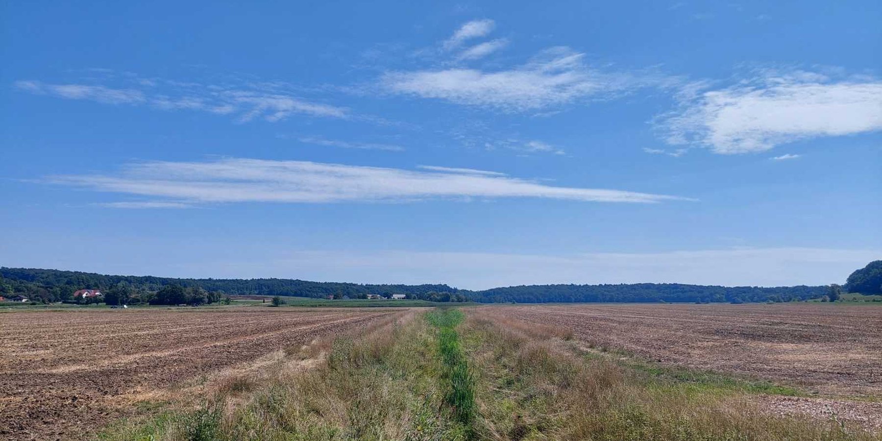
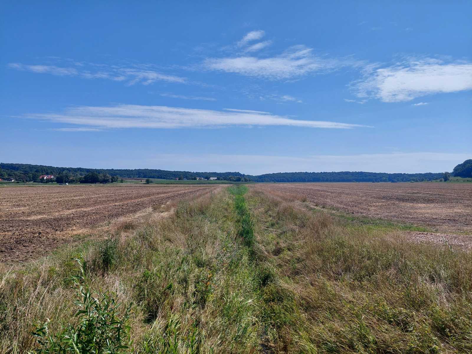
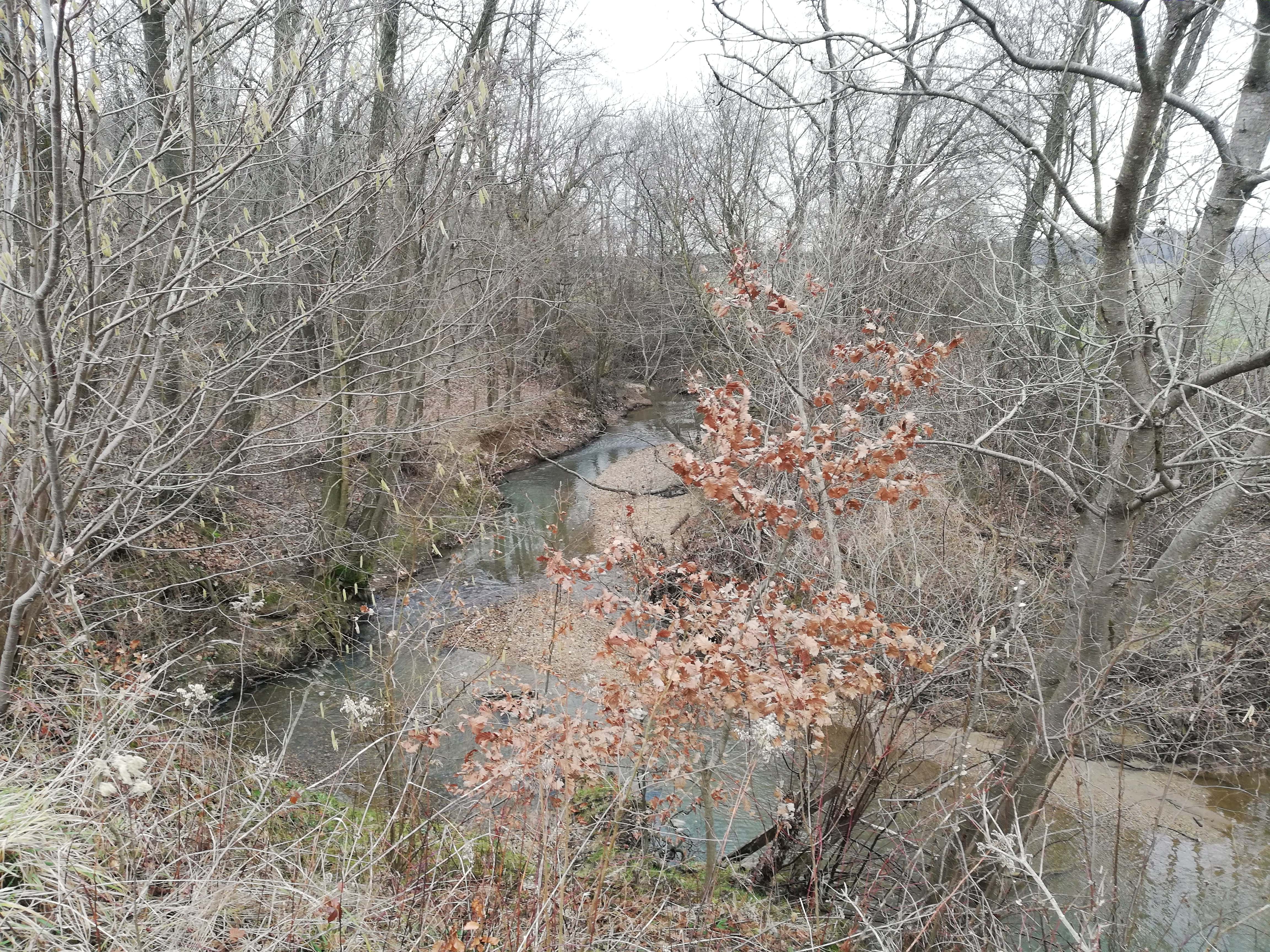
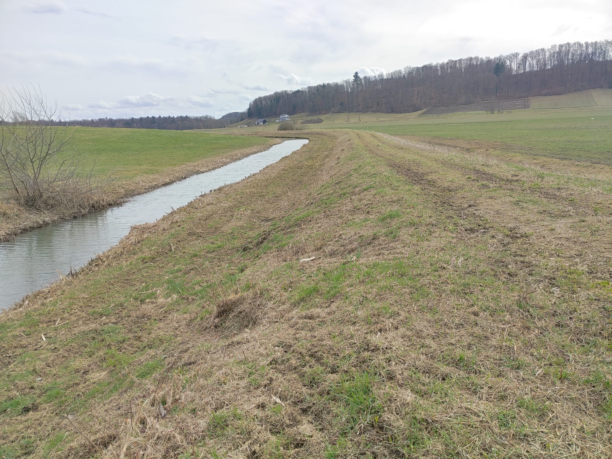
Riparian buffer strips are vegetative zones alongside watercourses. In compliance with EU and Slovenia’s Acts, these protective strips reduce soil erosion, filter pollutants, improve water quality, enhance biodiversity and support climate resilience.
2.2 การอธิบายแบบละเอียดของเทคโนโลยี
คำอธิบาย:
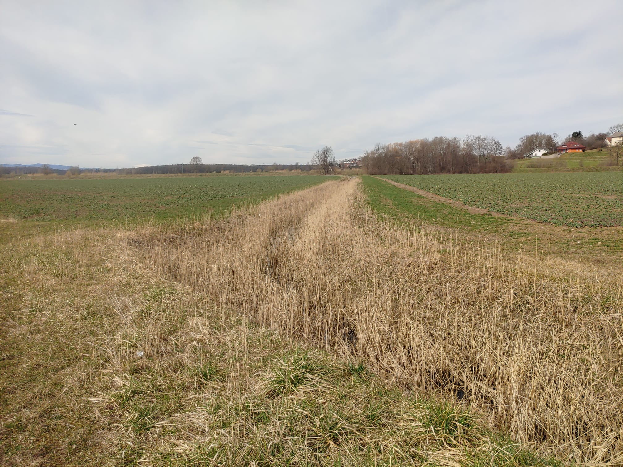
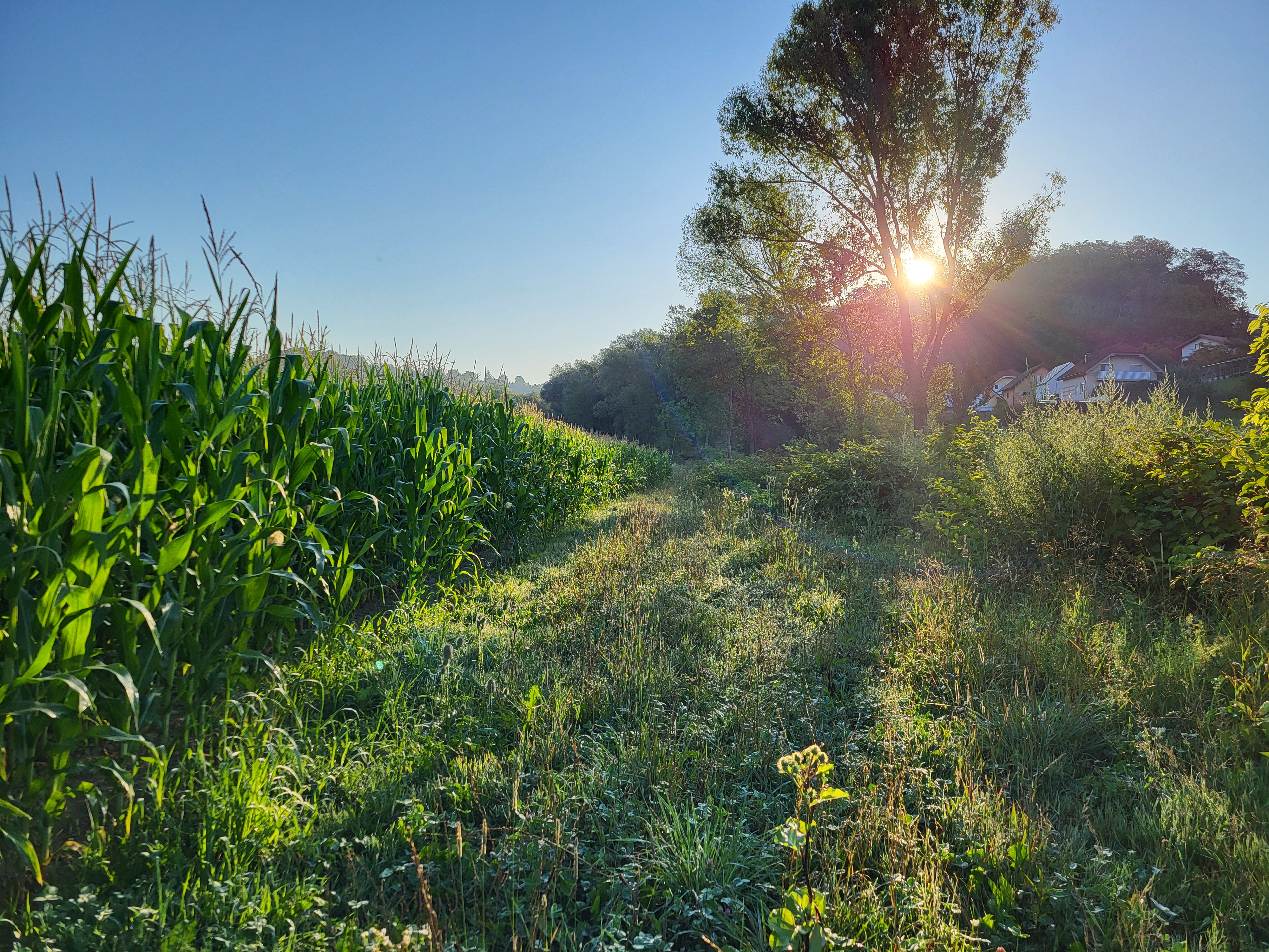
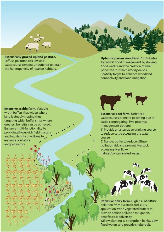
Riparian buffer strips are applied alongside all watercourses and drainage ditches in Slovenia. These buffer zones are legally mandated under the Water Act and GAEC 4 conditionality standards within the EU CAP 2023-2027 framework. Strips, of 3-15 m wide depending on size of the watercourse, serve as transition zones between cultivated fields and waterways, mitigating the impact of agriculture on aquatic ecosystems and surrounding environments.
Strips must comprise grasses, clover, alfalfa, native shrubs, and/or trees. The use of mineral and organic fertilizers is banned, as are pesticides and herbicides. Deep ploughing is prohibited, but surface tillage is allowed for maintenance and sowing (especially if the buffer strip is classified as agricultural land). Grazing is permitted, but with specific restrictions. If the farmer does not maintain the buffer strip, the area is excluded from the system of agricultural land in use and becomes ineligible for any subsidies.
The main purpose of riparian buffer strips is to protect and improve water quality, prevent soil erosion, and support biodiversity. By intercepting surface runoff, they reduce nitrogen, phosphorus, and pesticide contamination from agricultural land. The dense vegetation stabilizes riverbanks. The strips also enhance habitat connectivity for wildlife, providing nesting sites and food sources. Additionally, they play a role in flood mitigation by reducing the speed of stormwater runoff and thus improving water infiltration and retention.
To establish and maintain riparian buffer strips, an initial assessment of existing vegetation and soil determines whether additional planting is needed. If the area lacks sufficient vegetation, direct seeding with suitable species is carried out. Maintenance usually involves mowing, mulching, and occasional pruning. Pruning refers to the removal of overgrown trees and shrubs along the riverbank to prevent spreading onto agricultural land. This work typically requires tools such as a chainsaw and a tractor with a trailer for removing the cut woody material. Farmers must also comply with monitoring and reporting requirements under CAP regulations.
The benefits of riparian buffer strips are primarily environmental. By filtering pollutants before they enter watercourses, they contribute to cleaner water, reduced eutrophication, and improved aquatic ecosystems. They help maintain land productivity in the long term, reducing the need for costly interventions such as dredging or erosion control measures. The vegetation within the strips absorbs carbon, contributing to climate mitigation efforts. Additionally, by complying with regulations, farmers gain access to CAP subsidies and other environmental incentives, making implementation more financially viable.
Despite these advantages, land users have mixed opinions about such strips. Some farmers appreciate the additional forage production, and others find that the buffer zones serve as useful access paths around their fields, making machinery operation easier. However, many landowners dislike the loss of productive farmland, particularly those near first-order watercourses, where wider buffer strips are required. The loss of cultivated land can result in lower crop yields and income reductions, with farms experiencing up to a 6.2% decrease in arable land and financial losses estimated at 7,448 € per farm annually (Lešnik et al. 2024). Some farmers express concerns about the complexity of legal requirements and the costs associated with compliance and maintenance.
While riparian buffer strips are essential for environmental sustainability, their impact on farm economics must be carefully considered. Future strategies may involve flexible width requirements or integration with agroforestry systems to maximize their benefits while minimizing financial burdens.
2.3 รูปภาพของเทคโนโลยี
อัลบั้มสื่อบันทึก
2.5 ประเทศภูมิภาค หรือสถานที่ตั้งที่เทคโนโลยีได้นำไปใช้และได้รับการครอบคลุมโดยการประเมินนี้
ประเทศ:
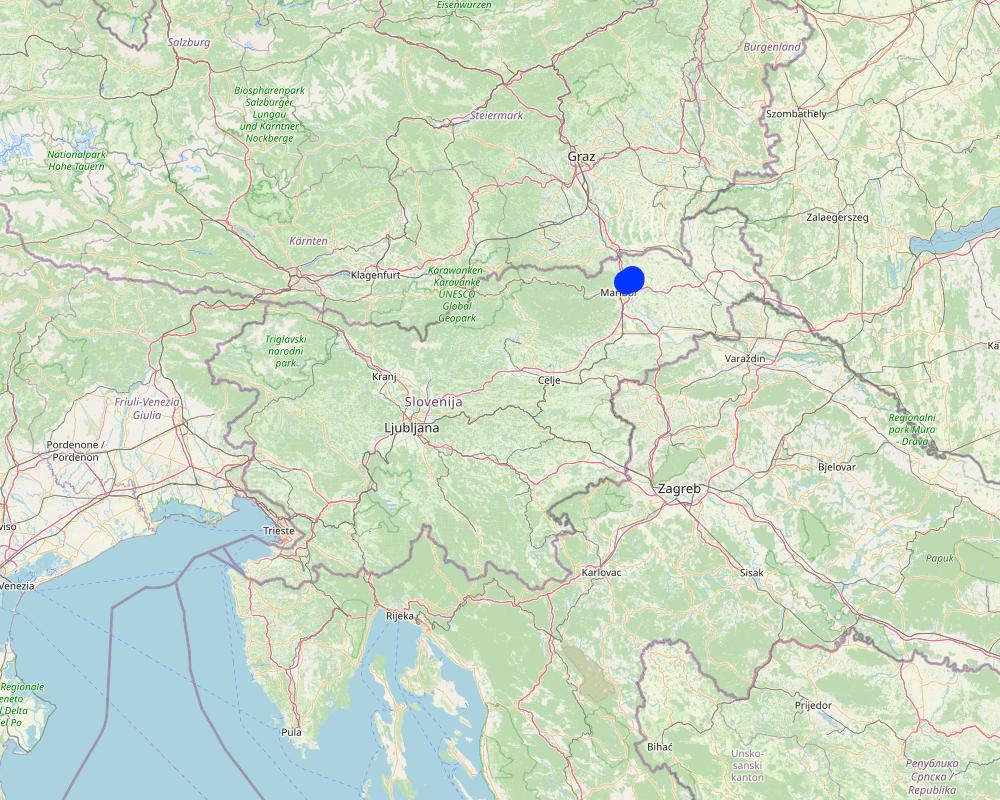
สโลวีเนีย
ภูมิภาค/รัฐ/จังหวัด:
Jareninski dol, Pernica
ข้อมูลจำเพาะเพิ่มเติมของสถานที่ตั้ง :
Vosek
ระบุการกระจายตัวของเทคโนโลยี:
- กระจายไปอย่างสม่ำเสมอในพื้นที่
If the Technology is evenly spread over an area, specify area covered (in km2):
137.0
If precise area is not known, indicate approximate area covered:
- < 0.1 ตร.กม.(10 เฮกตาร์)
Is/are the technology site(s) located in a permanently protected area?
ไม่ใช่
Map
×2.6 วันที่การดำเนินการ
ถ้าไม่รู้ปีที่แน่นอน ให้ระบุวันที่โดยประมาณ:
- น้อยกว่า 10 ปี (ไม่นานนี้)
2.7 คำแนะนำของเทคโนโลยี
- due to the legislative requirements of agricultural and water policy.
3. การจัดประเภทของเทคโนโลยี SLM
3.1 วัตถุประสงค์หลักของเทคโนโลยี
- ลด ป้องกัน ฟื้นฟู การเสื่อมโทรมของที่ดิน
- อนุรักษ์ระบบนิเวศน์
- ป้องกันพื้นที่ลุ่มน้ำ/บริเวณท้ายน้ำ โดยร่วมกับเทคโนโลยีอื่นๆ
- รักษาสภาพหรือปรับปรุงความหลากหลายทางชีวภาพ
3.2 ประเภทของการใช้ที่ดินในปัจจุบันที่ได้นำเทคโนโลยีไปใช้
Land use mixed within the same land unit:
ไม่ใช่

พื้นที่ปลูกพืช
- การปลูกพืชล้มลุกอายุปีเดียว
- การปลูกพืชยืนต้นที่ไม่มีเนื้อไม้
Annual cropping - Specify crops:
- fodder crops - alfalfa
- fodder crops - clover
- fodder crops - grasses
Perennial (non-woody) cropping - Specify crops:
- fodder crops - grasses
- fodder crops - legumes, clover
จำนวนของฤดูเพาะปลูกต่อปี:
- 1
Is intercropping practiced?
ใช่
If yes, specify which crops are intercropped:
A mix of grasses, clovers, and alfalfa.
Is crop rotation practiced?
ไม่ใช่
แสดงความคิดเห็น:
The area is generally classified as agricultural land but functions as a buffer zone along water bodies. Fodder crops are typically grown and either harvested for feed or mulched. In some cases, the area may be used for grazing livestock, although this is relatively rare.
3.3 Has land use changed due to the implementation of the Technology?
Has land use changed due to the implementation of the Technology?
- Yes (Please fill out the questions below with regard to the land use before implementation of the Technology)
Land use mixed within the same land unit:
ไม่ใช่
พื้นที่ปลูกพืช
- การปลูกพืชล้มลุกอายุปีเดียว
Annual cropping - Specify crops:
- cereals - barley
- cereals - maize
- cereals - wheat (winter)
Is intercropping practiced?
ไม่ใช่
Is crop rotation practiced?
ใช่
ถ้าใช่ ระบุ:
General crop rotation is practiced, typically alternating between cereals and maize.
3.4 การใช้น้ำ
การใช้น้ำของที่ดินที่มีการใช้เทคโนโลยีอยู่:
- จากน้ำฝน
3.5 กลุ่ม SLM ที่ตรงกับเทคโนโลยีนี้
- การปรับปรุงดิน / พืชคลุมดิน
- การจัดการน้ำผิวดิน (น้ำพุ แม่น้ำทะเลสาบ ทะเล)
- การป้องกัน / การจัดการพื้นที่ชุ่มน้ำ
3.6 มาตรการ SLM ที่ประกอบกันเป็นเทคโนโลยี

มาตรการอนุรักษ์ด้วยวิธีพืช
- V1: ต้นไม้และพุ่มไม้คลุมดิน
- V2: หญ้าและไม้ยืนต้น
- V5: อื่นๆ
แสดงความคิดเห็น:
It is considered a vegetative measure because it relies primarily on the establishment and management of permanent vegetation such as grasses, legumes (e.g., clover, alfalfa), shrubs, and trees.
3.7 รูปแบบหลักของการเสื่อมโทรมของที่ดินที่ได้รับการแก้ไขโดยเทคโนโลยี

การกัดกร่อนของดินโดยน้ำ
- Wt (Loss of topsoil): การสูญเสียดินชั้นบนหรือการกัดกร่อนที่ผิวดิน
- Wr (Riverbank erosion): การกัดกร่อนริมฝั่งแม่น้ำ
- Wo (Offsite degradation): ผลกระทบนอกพื้นที่

การเสื่อมโทรมของดินทางด้านเคมี
- Cn (Fertility decline): ความอุดมสมบูรณ์และปริมาณอินทรียวัตถุในดินถูกทำให้ลดลงไป (ไม่ได้เกิดจากสาเหตุการกัดกร่อน)

การเสื่อมโทรมของดินทางด้านชีวภาพ
- Bc (Reduction of vegetation cover): การลดลงของจำนวนพืชที่ปกคลุมดิน
- Bh (Loss of habitat): การสูญเสียแหล่งที่อยู่
- Bs (Quality and species composition): องค์ประกอบหรือความหลากหลายทางคุณภาพและชนิดพันธุ์ลดลง

การเสื่อมโทรมของน้ำ
- Hw (Reduction of the buffering capacity of wetland): การลดลงของความทนทานต่อการเปลี่ยนแปลง ของพื้นที่ชุ่มน้ำ
3.8 การป้องกัน การลดลง หรือการฟื้นฟูความเสื่อมโทรมของที่ดิน
ระบุเป้าหมายของเทคโนโลยีกับความเสื่อมโทรมของที่ดิน:
- ป้องกันความเสื่อมโทรมของที่ดิน
- ลดความเสื่อมโทรมของดิน
4. ข้อมูลจำเพาะด้านเทคนิค กิจกรรมการนำไปปฏิบัติใช้ ปัจจัยนำเข้า และค่าใช้จ่าย
4.1 แบบแปลนทางเทคนิคของเทคโนโลยี
ข้อมูลจำเพาะด้านเทคนิค (แบบแปลนทางเทคนิคของเทคโนโลยี):
Riparian buffer strips are protected zones established along watercourses to reduce agricultural impacts on soil and water quality. These strips remain part of the agricultural land base and may be managed as grassland, limited arable land, or grazing areas. However, to maintain their protective function, specific agricultural inputs and activities are restricted within these areas. If the buffer strips are not properly maintained, they are excluded from the system of agricultural land in use and become ineligible for any subsidies.
Management and Activity Restrictions (applicable to buffer strips only):
Soil tillage: Deep ploughing is prohibited; only shallow (low) tillage is permitted for maintenance and sowing.
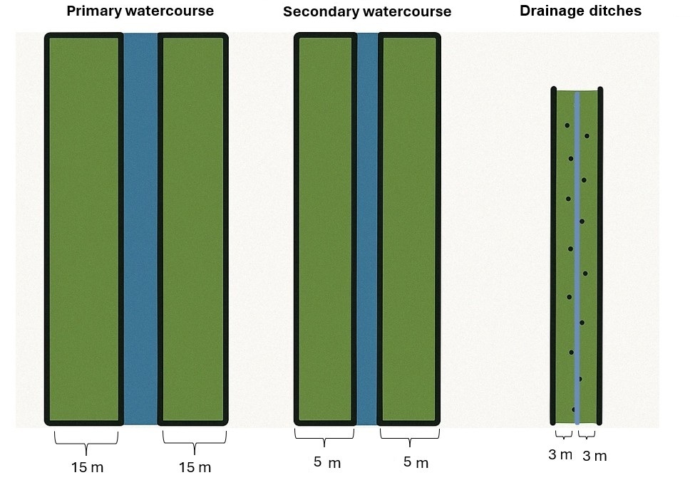
Buffer widths (according to the Water Act):
- 15 m along primary watercourses
- 5 m along secondary watercourses
- 3 m along drainage ditches
Vegetation allowed: Grass, grass-clover mixtures, clover-grass mixtures, alfalfa, clover, native shrubs, and trees.
Fertilization: Application of mineral and organic fertilizers is prohibited. Storage or disposal of manure is not allowed. Natural manure from grazing animals is tolerated.
Plant protection products: The use of pesticides has been prohibited in buffer strips since 2002.
Livestock grazing: Grazing is allowed but must not damage the structure of the water body. Animals may drink from the watercourse at designated points, but supplementary feeding is not permitted within the strip.
ผู้เขียน:
Gregor Kramberger
วันที่:
18/04/2025
ผู้เขียน:
Lorna J. Cole, Jenni Stockan, Rachel Helliwell
วันที่:
01/07/2020
4.2 ข้อมูลทั่วไปเกี่ยวกับการคำนวณปัจจัยนำเข้าและค่าใช้จ่าย
ให้ระบุว่าค่าใช้จ่ายและปัจจัยนำเข้าได้รับการคำนวณอย่างไร:
- ต่อพื้นที่ที่ใช้เทคโนโลยี
ระบุขนาดและหน่วยพื้นที่:
31,2 hectares
อื่นๆ หรือสกุลเงินประจำชาติ (ระบุ):
EUR
If relevant, indicate exchange rate from USD to local currency (e.g. 1 USD = 79.9 Brazilian Real): 1 USD =:
0.87
ระบุค่าเฉลี่ยของค่าจ้างในการจ้างแรงงานต่อวัน:
114
4.3 กิจกรรมเพื่อการจัดตั้ง
| กิจกรรม | Timing (season) | |
|---|---|---|
| 1. | Purchase grass seed mixture | 1st year |
| 2. | Pre-sowing preparation and sowing | 1st year |
แสดงความคิดเห็น:
Select grass species or mixtures adapted to local soil and climatic conditions. Minimal soil disturbance recommended; shallow cultivation to ensure proper seed-soil contact.
4.4 ค่าใช้จ่ายของปัจจัยนำเข้าที่จำเป็นสำหรับการจัดตั้ง
| ปัจจัยนำเข้า | หน่วย | ปริมาณ | ค่าใช้จ่ายต่อหน่วย | ค่าใช้จ่ายทั้งหมดต่อปัจจัยนำเข้า | %ของค่าใช้จ่ายที่ก่อให้เกิดขึ้นโดยผู้ใช้ที่ดิน | |
|---|---|---|---|---|---|---|
| แรงงาน | Own labor | hour | 3.0 | 9.0 | 27.0 | 100.0 |
| แรงงาน | Pre-sowing preparation and sowing | hour | 3.0 | 35.0 | 105.0 | 100.0 |
| วัสดุด้านพืช | Grass seed mixture | kg/ha | 16.412 | 5.6 | 91.91 | 100.0 |
| ค่าใช้จ่ายทั้งหมดของการจัดตั้งเทคโนโลยี | 223.91 | |||||
| Total costs for establishment of the Technology in USD | 257.37 | |||||
แสดงความคิดเห็น:
Labor and pre-sowing preparation and sowing also include travel time between sites. The total size of the farm is 31,2 hectares. An area of 4103 m² falls under the restricted buffer strip zone at his farm.
4.5 การบำรุงรักษาสภาพหรือกิจกรรมที่เกิดขึ้นเป็นประจำ
| กิจกรรม | ช่วงระยะเวลา/ความถี่ | |
|---|---|---|
| 1. | Mulching/mowing | 2 times per year |
| 2. | Pruning and clearing of overgrowth | 1 time, winter time |
แสดงความคิดเห็น:
4103 m² of agricultural land represents the buffer strips that the farmer actively manages and maintains. Pruning or cutting of woody vegetation, such as trees or shrubs, when they begin to encroach on agricultural land near the riverbank. Farmers typically carry out this work in winter, but it is difficult to estimate the cost, as it can vary significantly depending on the extent of overgrowth.
4.6 ค่าใช้จ่ายของปัจจัยนำเข้าและกิจกรรมที่เกิดขึ้นเป็นประจำที่ต้องการการบำรุงรักษา (ต่อปี)
| ปัจจัยนำเข้า | หน่วย | ปริมาณ | ค่าใช้จ่ายต่อหน่วย | ค่าใช้จ่ายทั้งหมดต่อปัจจัยนำเข้า | %ของค่าใช้จ่ายที่ก่อให้เกิดขึ้นโดยผู้ใช้ที่ดิน | |
|---|---|---|---|---|---|---|
| แรงงาน | Mulching/mowing | hours | 6.0 | 32.0 | 192.0 | 100.0 |
| แรงงาน | Pruning and clearing of overgrowth | hours | 4.0 | 4.5 | 18.0 | 100.0 |
| แรงงาน | Own labor | hours | 10.0 | 9.0 | 90.0 | 100.0 |
| ค่าใช้จ่ายทั้งหมดของการบำรุงรักษาสภาพเทคโนโลยี | 300.0 | |||||
| Total costs for maintenance of the Technology in USD | 344.83 | |||||
แสดงความคิดเห็น:
Opportunity costs were calculated based on the loss of arable land due to the establishment of buffer zones in 2024 on Farm Ropic (total farm size: 32,2 ha, of which 28,6 ha is arable land). The planned crop rotation for that year included wheat, oil pumpkins, barley, and maize. The income foregone represents the estimated revenue that could have been generated from these crops on the area now designated as buffer strips (a total of 4103 m² of arable land).
The estimated income losses by crop type are:
Winter wheat: 113.52 €
Oil pumpkin: 396.80 €
Winter barley: 120.60 €
Grain maize: 68.04 €.
4.7 ปัจจัยสำคัญที่สุดที่มีผลกระทบต่อค่าใช้จ่าย
ปัจจัยสำคัญที่สุดที่มีผลกระทบต่อค่าใช้จ่ายต่างๆ:
Exact costs are difficult to estimate as they depend heavily on the specific location. If regular maintenance, such as mulching/mowing, is carried out, annual costs remain low, and pruning and clearing of overgrowth work is likely unnecessary. Costs are calculated for farm Ropič.
5. สิ่งแวดล้อมทางธรรมชาติและของมนุษย์
5.1 ภูมิอากาศ
ฝนประจำปี
- < 250 ม.ม.
- 251-500 ม.ม.
- 501-750 ม.ม.
- 751-1,000 ม.ม.
- 1,001-1,500 ม.ม.
- 1,501-2,000 ม.ม.
- 2,001-3,000 ม.ม.
- 3,001-4,000 ม.ม.
- > 4,000 ม.ม.
ระบุปริมาณน้ำฝนเฉลี่ยรายปี (ถ้ารู้) :หน่วย ม.ม.
1032.00
ข้อมูลจำเพาะ/ความคิดเห็นเรื่องปริมาณน้ำฝน:
The most precipitation falls in summer, the months with the highest average precipitation are August and September, the least precipitation falls in winter, in January and February at least, and in principle more precipitation falls in autumn than in spring.
ระบุชื่อของสถานีตรวดวัดอากาศที่ใช้อ้างอิงคือ:
Jareninski Vrh (1991-2020)
เขตภูมิอากาศเกษตร
- กึ่งชุ่มชื้น
The average annual air temperature at Jareninski Vrh during the reference period 1991–2020 was 10.1 °C.
5.2 สภาพภูมิประเทศ
ค่าเฉลี่ยความลาดชัน:
- ราบเรียบ (0-2%)
- ลาดที่ไม่ชัน (3-5%)
- ปานกลาง (6-10%)
- เป็นลูกคลื่น (11-15%)
- เป็นเนิน (16-30%)
- ชัน (31-60%)
- ชันมาก (>60%)
ธรณีสัณฐาน:
- ที่ราบสูง/ที่ราบ
- สันเขา
- ไหล่เขา
- ไหล่เนินเขา
- ตีนเนิน
- หุบเขา
ระดับความสูง:
- 0-100 เมตร
- 101-500 เมตร
- 501-1,000 เมตร
- 1,001-1,500 เมตร
- 1,501-2,000 เมตร
- 2,001-2,500 เมตร
- 2,501-3,000 เมตร
- 3,001-4,000 เมตร
- > 4,000 เมตร
ให้ระบุถ้าเทคโนโลยีได้ถูกนำไปใช้:
- บริเวณแอ่งบนที่ราบ (concave situations)
ความคิดเห็นและข้อมูลจำเพาะเพิ่มเติมเรื่องสภาพภูมิประเทศ:
There are depressions, settlements are in the valley, concave type.
5.3 ดิน
ค่าเฉลี่ยความลึกของดิน:
- ตื้นมาก (0-20 ซ.ม.)
- ตื้น (21-50 ซ.ม.)
- ลึกปานกลาง (51-80 ซ.ม.)
- ลึก (81-120 ซ.ม.)
- ลึกมาก (>120 ซ.ม.)
เนื้อดิน (ดินชั้นบน):
- ปานกลาง (ดินร่วน ทรายแป้ง)
เนื้อดินล่าง (> 20 ซ.ม.ต่ำจากผิวดิน):
- ปานกลาง (ดินร่วน ทรายแป้ง)
อินทรียวัตถุในดิน:
- สูง (>3%)
5.4 ความเป็นประโยชน์และคุณภาพของน้ำ
ระดับน้ำใต้ดิน:
5-50 เมตร
น้ำไหลบ่าที่ผิวดิน:
ดี
คุณภาพน้ำ (ที่ยังไม่ได้บำบัด):
เป็นน้ำใช้เพื่อการเกษตรเท่านั้น (การชลประทาน)
Water quality refers to:
surface water
ความเค็มของน้ำเป็นปัญหาหรือไม่:
ไม่ใช่
กำลังเกิดน้ำท่วมในพื้นที่หรือไม่:
ใช่
บ่อยครั้ง:
เป็นครั้งเป็นคราว
ความคิดเห็นและข้อมูลจำเพาะเพิ่มเติมเรื่องคุณภาพและปริมาณน้ำ:
Hydromelioration was carried out in the area, a drainage system and water retention systems (e.g. ponds and basins) were arranged.
5.5 ความหลากหลายทางชีวภาพ
ความหลากหลายทางชนิดพันธุ์:
- ปานกลาง
ความหลากหลายของแหล่งที่อยู่:
- ปานกลาง
5.6 ลักษณะของผู้ใช้ที่ดินที่นำเทคโนโลยีไปปฏิบัติใช้
อยู่กับที่หรือเร่ร่อน:
- อยู่กับที่
แนวทางการตลาดของระบบการผลิต:
- ทำการค้า/การตลาด
รายได้ที่มาจากนอกฟาร์ม:
- 10-50% ของรายได้ทั้งหมด
ระดับของความมั่งคั่งโดยเปรียบเทียบ:
- พอมีพอกิน
เป็นรายบุคคล/ครัวเรือน:
- เป็นรายบุคคล/ครัวเรือน
ระดับของการใช้เครื่องจักรกล:
- การใช้เครื่องจักรหรือเครื่องยนต์
เพศ:
- ชาย
อายุของผู้ใช้ที่ดิน:
- วัยกลางคน
5.7 Average area of land used by land users applying the Technology
- < 0.5 เฮกตาร์
- 0.5-1 เฮกตาร์
- 1-2 เฮกตาร์
- 2-5 เฮกตาร์
- 5-15 เฮกตาร์
- 15-50 เฮกตาร์
- 50-100 เฮกตาร์
- 100-500 เฮกตาร์
- 500-1,000 เฮกตาร์
- 1,000-10,000 เฮกตาร์
- >10,000 เฮกตาร์
พิจารณาว่าเป็นขนาดเล็ก กลาง หรือขนาดใหญ่ (ซึ่งอ้างอิงถึงบริบทระดับท้องถิ่น):
- ขนาดกลาง
5.8 กรรมสิทธิ์ในที่ดิน สิทธิในการใช้ที่ดินและสิทธิในการใช้น้ำ
กรรมสิทธิ์ในที่ดิน:
- รายบุคคล ได้รับสิทธิครอบครอง
สิทธิในการใช้ที่ดิน:
- เช่า
- รายบุคคล
สิทธิในการใช้น้ำ:
- เกี่ยวกับชุมชน (ถูกจัดระเบียบ)
ระบุ:
Based on national legal system.
5.9 การเข้าถึงบริการและโครงสร้างพื้นฐาน
สุขภาพ:
- จน
- ปานกลาง
- ดี
การศึกษา:
- จน
- ปานกลาง
- ดี
ความช่วยเหลือทางด้านเทคนิค:
- จน
- ปานกลาง
- ดี
การจ้างงาน (เช่น ภายนอกฟาร์ม):
- จน
- ปานกลาง
- ดี
ตลาด:
- จน
- ปานกลาง
- ดี
พลังงาน:
- จน
- ปานกลาง
- ดี
ถนนและการขนส่ง:
- จน
- ปานกลาง
- ดี
น้ำดื่มและการสุขาภิบาล:
- จน
- ปานกลาง
- ดี
บริการด้านการเงิน:
- จน
- ปานกลาง
- ดี
6. ผลกระทบและสรุปคำบอกกล่าว
6.1 ผลกระทบในพื้นที่ดำเนินการ (On-site) จากการใช้เทคโนโลยี
ผลกระทบทางด้านเศรษฐกิจและสังคม
การผลิต
การผลิตพืชผล
แสดงความคิดเห็น/ระบุ:
The loss of productive farmland depends on the width of buffer strips and the total farm size. Impact on yield varies depending on the previous land use (e.g., maize, wheat, barley were replaced by permanent vegetation).
การผลิตพืชที่ใช้เลี้ยงปศุสัตว์
แสดงความคิดเห็น/ระบุ:
Some farmers report that grasses grown in riparian buffer strips can be harvested for hay or grazed by livestock, partially compensating for lost crop land. Dairy or mixed farms benefit more from fodder production.
พื้นที่สำหรับการผลิต
แสดงความคิดเห็น/ระบุ:
The implementation of riparian buffer strips directly reduces the production area, as these zones must be permanently maintained with grass, shrubs, or trees instead of crops.
การจัดการที่ดิน
แสดงความคิดเห็น/ระบุ:
Less flexibility in field layout and crop management (without plowing, fertilization, or pesticides). Additional maintenance like mulching and active cultivation area is reduced. Buffer strips create machinery access/driving zones and reduce erosion.
ความเป็นประโยชน์และคุณภาพของน้ำ
คุณภาพน้ำดื่ม
แสดงความคิดเห็น/ระบุ:
They filter agricultural runoff and prevent fertilizers, pesticides and sediments from entering waterways. They reduce nitrate leaching and chemical pollution, improving the quality of groundwater and surface water.
คุณภาพน้ำสำหรับปศุสัตว์
แสดงความคิดเห็น/ระบุ:
They filter pollutants before they reach streams and water sources, improving water quality for grazing animals.
รายได้และค่าใช้จ่าย
รายได้จากฟาร์ม
แสดงความคิดเห็น/ระบุ:
The loss of productive land due to buffer strips reduces crop output, affecting farm revenue.
ภาระงาน
แสดงความคิดเห็น/ระบุ:
Farmers need to mow or mulch buffer strips regularly to prevent overgrowth. Sometimes tree maintenance is necessary.
ผลกระทบด้านสังคมวัฒนธรรมอื่น ๆ
โอกาสทางด้านสันทนาการ
แสดงความคิดเห็น/ระบุ:
Access to water bodies for recreational purposes.
ผลกระทบด้านนิเวศวิทยา
วัฐจักรน้ำหรือน้ำบ่า
คุณภาพน้ำ
แสดงความคิดเห็น/ระบุ:
They filter out nitrates, phosphorus, pesticides, and sediments before they reach water bodies.
น้ำไหลบ่าที่ผิวดิน
แสดงความคิดเห็น/ระบุ:
They slow surface runoff, increase water infiltration, and reduce the transport of sediments, fertilizers, and pesticides into water bodies.
ดิน
สิ่งปกคลุมดิน
แสดงความคิดเห็น/ระบุ:
They maintaiThey maintain continuous vegetation cover in the zone around the water body.n continuous vegetation cover and reduce soil exposure to erosion.
การสูญเสียดิน
แสดงความคิดเห็น/ระบุ:
They significantly reduce soil erosion, they stabilize the soil and trap sediment, especially during floods.
ความหลากหลายทางชีวภาพของพืชและสัตว์
การปกคลุมด้วยพืช
แสดงความคิดเห็น/ระบุ:
Permanent vegetation cover in buffer strips, improving soil stability and biodiversity.
ความหลากหลายทางชีวภาพของพืช
แสดงความคิดเห็น/ระบุ:
Increased diversity of grasses, legumes, shrubs, and trees, creating a more resilient ecosystem.
ความหลากหลายทางชีวภาพของสัตว์
แสดงความคิดเห็น/ระบุ:
Riparian buffer strips provide habitat for birds, insects, amphibians, and small mammals, increasing biodiversity and ecological stability.
ชนิดพันธุ์ที่ให้ประโยชน์
แสดงความคิดเห็น/ระบุ:
Increased presence of pollinators, predatory insects, and other beneficial organisms.
ความหลากหลายของสัตว์
แสดงความคิดเห็น/ระบุ:
With riparian buffer strips we create diverse habitats by introducing a mix of grasses, shrubs, and trees, supporting a wider range of species.
ลดความเสี่ยงของภัยพิบัติ
ผลกระทบจากน้ำท่วม
แสดงความคิดเห็น/ระบุ:
Deep-rooted vegetation stabilizes riverbanks, preventing erosion and minimizing damage during high water events.
Specify assessment of on-site impacts (measurements):
The data provided are not based on direct measurements but are derived from statements by the land user (farmer) and expert judgement from an agricultural adviser. They reflect practical experience and informed estimates rather than measured field data.
6.2 ผลกระทบนอกพื้นที่ดำเนินการ (Off-site) จากการใช้เทคโนโลยี
การเกิดมลพิษในน้ำบาดาลหรือแม่น้ำ
แสดงความคิดเห็น/ระบุ:
Due to a significant reduction in the leaching of pollutants, leading to cleaner water sources.
ความสามารถต้านทานการเปลี่ยนแปลง / ความสามารถในการคัดกรอง
แสดงความคิดเห็น/ระบุ:
Significant reduction in pollutants as buffer strips trap sediments and filter nutrients and chemicals before reaching watercourses.
Specify assessment of off-site impacts (measurements):
The data provided are not based on direct measurements but are derived from statements by the land user (farmer) and expert judgement from an agricultural adviser. They reflect practical experience and informed estimates rather than measured field data.
6.3 การเผชิญและความตอบสนองของเทคโนโลยีต่อการเปลี่ยนแปลงสภาพภูมิอากาศที่ค่อยเป็นค่อยไป และสภาพรุนแรงของภูมิอากาศ / ภัยพิบัติ (ที่รับรู้ได้โดยผู้ใช้ที่ดิน)
การเปลี่ยนแปลงสภาพภูมิอากาศที่ค่อยเป็นค่อยไป
การเปลี่ยนแปลงสภาพภูมิอากาศที่ค่อยเป็นค่อยไป
| ฤดู | increase or decrease | เทคโนโลยีมีวิธีการรับมืออย่างไร | |
|---|---|---|---|
| อุณหภูมิประจำปี | เพิ่มขึ้น | ปานกลาง | |
| อุณหภูมิตามฤดูกาล | ฤดูร้อน | เพิ่มขึ้น | ปานกลาง |
| อุณหภูมิตามฤดูกาล | ฤดูใบไม้ผลิ | เพิ่มขึ้น | ปานกลาง |
| อุณหภูมิตามฤดูกาล | ฤดูใบไม้ร่วง | เพิ่มขึ้น | ปานกลาง |
| อุณหภูมิตามฤดูกาล | ฤดูหนาว | เพิ่มขึ้น | ปานกลาง |
| ฝนตามฤดู | ฤดูร้อน | เพิ่มขึ้น | ดีมาก |
| ฝนตามฤดู | ฤดูใบไม้ผลิ | เพิ่มขึ้น | ดีมาก |
| ฝนตามฤดู | ฤดูใบไม้ร่วง | ลดลง | ปานกลาง |
สภาพรุนแรงของภูมิอากาศ (ภัยพิบัติ)
ภัยพิบัติทางอุตุนิยมวิทยา
| เทคโนโลยีมีวิธีการรับมืออย่างไร | |
|---|---|
| พายุฝนประจำท้องถิ่น | ดีมาก |
ภัยพิบัติจากสภาพภูมิอากาศ
| เทคโนโลยีมีวิธีการรับมืออย่างไร | |
|---|---|
| คลื่นความร้อน | ดี |
ภัยพิบัติจากน้ำ
| เทคโนโลยีมีวิธีการรับมืออย่างไร | |
|---|---|
| น้ำท่วมตามปกติ (แม่น้ำ) | ดีมาก |
| น้ำท่วมฉับพลัน | ดีมาก |
6.4 การวิเคราะห์ค่าใช้จ่ายและผลประโยชน์ที่ได้รับ
ผลประโยชน์ที่ได้รับเปรียบเทียบกับค่าใช้จ่ายในการจัดตั้งเป็นอย่างไร (จากมุมมองของผู้ใช้ที่ดิน)
ผลตอบแทนระยะสั้น:
ด้านลบเล็กน้อย
ผลตอบแทนระยะยาว:
ด้านบวกเล็กน้อย
ผลประโยชน์ที่ได้รับเปรียบเทียบกับค่าใช้จ่ายในการบำรุงรักษาหรือต้นทุนที่เกิดขึ้นซ้ำอีก เป็นอย่างไร (จากมุมมองของผู้ใช้ที่ดิน)
ผลตอบแทนระยะสั้น:
เป็นกลางหรือสมดุล
ผลตอบแทนระยะยาว:
ด้านบวก
แสดงความคิดเห็น:
Establishment costs are high, including soil preparation, seeding, and potential fencing, while the loss of productive land immediately reduces farm income. Subsidies may offset some costs, but they do not fully compensate for the initial financial impact. In a long-term benefits such as improved soil stability, water quality, and flood protection reduce future expenses. Over time, subsidies, reduced erosion, and potential fodder production help balance the initial investment.
Maintenance costs, such as mowing or mulching and tree maintenance, add labor and equipment expenses, but the absence of fertilizer and pesticide costs helps balance them. Subsidies for maintaining buffer strips further offset these recurrent costs, keeping short-term financial impact neutral. Once vegetation is established, maintenance costs decrease, requiring only occasional mowing or grazing. Over time, benefits like erosion control, improved soil health, and reduced flood damage outweigh the minimal upkeep expenses, making the practice economically sustainable.
6.5 การปรับตัวของเทคโนโลยี
- > 50%
ถ้ามีข้อมูลให้บอกปริมาณด้วย (จำนวนของครัวเรือนหรือครอบคลุมพื้นที่):
All farmers in the area must comply with the implementation of riparian buffer strips as part of the GAEC 4 standard under CAP conditionality. This means that all agricultural land users with fields adjacent to watercourses are required to establish and maintain these protective strips, ensuring compliance with national and EU environmental regulations.
Of all those who have adopted the Technology, how many did so spontaneously, i.e. without receiving any material incentives/ payments?
- 0-10%
6.6 การปรับตัว
เทคโนโลยีได้รับการปรับเปลี่ยนเมื่อเร็วๆนี้ เพื่อให้ปรับตัวเข้ากับสภาพที่กำลังเปลี่ยนแปลงหรือไม่:
ใช่
อื่น ๆ (ระบุ):
CAP
ให้ระบุการปรับตัวของเทคโนโลยี (การออกแบบ วัสดุหรือชนิดพันธุ์ เป็นต้น):
The requirements for riparian buffer strips have been updated to align with GAEC 4 conditionality and the EU Strategic Plan Regulation. The establishment of buffer strips is now mandatory along first-order watercourses (15 m wide), second-order watercourses (5 m wide), and drainage ditches (3 m wide).
Within these buffer zones, the use of organic and mineral fertilizers, as well as plant protection products (PPPs), is strictly prohibited. Ploughing is not allowed, but shallow tillage is permitted for maintenance (mowing, mulching, or grazing) and for preparing soil for sowing approved crops.
The buffer strips can be covered with grass, grass-legume mixtures, clover, alfalfa, naturally occurring vegetation, shrubs, or trees. Livestock grazing is permitted but must not alter the structure of the riverbank. Animals cannot be supplementary fed within the buffer zones and must be provided drinking water only at designated, controlled locations in small groups to minimize environmental impact.
6.7 จุดแข็ง / ข้อได้เปรียบ / โอกาสของเทคโนโลยี
| จุดแข็ง / ข้อได้เปรียบ / โอกาสในทัศนคติของผู้ใช้ที่ดิน |
|---|
| Buffer strips stabilize soil and prevent erosion. |
| They reduce the impact of flooding on agricultural land. |
| Less leaching of nutrients and plant protection products into water. |
| Additional turning point and driving path for machines. |
| Establishing and maintaining buffer strips can qualify farmers for financial incentives and support programs. |
| Additional shelters for wildlife. |
| จุดแข็ง / ข้อได้เปรียบ / โอกาสในทัศนคติของผู้รวบรวมหรือวิทยากรหลัก |
|---|
| These buffers effectively filter out nutrients, pesticides, and sediments from agricultural runoff, thereby enhancing the quality of nearby water bodies. |
| By stabilizing stream banks, riparian buffers reduce soil erosion, preserving valuable topsoil and maintaining land productivity. |
| They provide critical habitats for various wildlife species, promoting biodiversity and creating wildlife corridors in agricultural landscapes. |
| Riparian buffer strips contribute to ecosystem services like carbon sequestration and pollination, supporting broader environmental goals. |
6.8 จุดอ่อน / ข้อเสียเปรียบ / ความเสี่ยงของเทคโนโลยีและวิธีการแก้ไข
| จุดอ่อน / ข้อเสียเปรียบ / ความเสี่ยงในทัศนคติของผู้ใช้ที่ดิน | มีวิธีการแก้ไขได้อย่างไร |
|---|---|
| The buffer zones are too wide, significantly reducing cultivated land area, which negatively impacts crop yields and farm income. | Increase subsidies and financial incentives for farmers to compensate for the loss of productive land within riparian buffer strips. |
| Maintenance tasks such as mowing, mulching, or controlled grazing require extra labor and resources and establishing buffer strips involves expenses for seeds, machinery, soil preparation, and potential fencing. | Provide additional payments for ongoing maintenance activities or investment support to offset initial establishment costs. |
| The legislation and administrative requirements are complex, involving numerous regulations that farmers find difficult to understand and follow. | Provide more accessible, user-friendly information, along with targeted advisory services and educational programs to help farmers better navigate these rules. |
| จุดอ่อน / ข้อเสียเปรียบ / ความเสี่ยงในทัศนคติของผู้รวบรวมหรือวิทยากรหลัก | มีวิธีการแก้ไขได้อย่างไร |
|---|---|
| In certain conditions, the redirected flow of water due to buffer strips may weaken streambanks, leading to erosion and land loss. | Designing buffer zones with appropriate vegetation, width and adapted to local conditions, and regularly monitoring the situation. |
| Over time, buffer strips can become saturated with nutrients, reducing their effectiveness and possibly turning them into sources of pollution. | Regular vegetation management, harvesting or removal of biomass to prevent nutrient accumulation. Crop rotation or periodic rejuvenation of buffer zone vegetation to maintain its filtering capacity. |
| Proper upkeep involves tasks like weed control, pruning, replanting, and protection against wildlife, increasing the workload for farmers. | Provide farmers with targeted financial support or subsidies for maintenance tasks, promote low-maintenance vegetation species, and offer technical assistance or training in efficient management practices. |
| Initial setup requires investment in planting, while ongoing maintenance demands additional labor and resources. | Offer financial incentives, subsidies, or cost-sharing programs to cover initial establishment expenses, and provide ongoing support or training to minimize labor and maintenance costs. |
7. การอ้างอิงและการเชื่อมต่อ
7.1 วิธีการและแหล่งข้อมูล
- การสัมภาษณ์กับผู้ใช้ที่ดิน
1 (Andrej Ropič, farmer)
- การสัมภาษณ์ผู้เชี่ยวชาญด้าน SLM หรือผู้ชำนาญ
2 (Chamber of Agriculture and Forestry of Slovenia (KGZS) – Institute of Agriculture and Forestry Maribor; Tamara Korošec and Timotej Horvat)
- การเก็บรวบรวมมาจากรายงานและเอกสารที่มีอยู่
CAP and Slovenian Strategic Plan 2023-2027.
วันที่เก็บรวบรวมข้อมูล(ภาคสนาม) :
17/01/2023
แสดงความคิดเห็น:
Visit to the farm and farmer interview.
7.2 การอ้างอิงถึงสิ่งตีพิมพ์
หัวข้อ, ผู้เขียน, ปี, หมายเลข ISBN:
Cole, L. J., Stockan, J., & Helliwell, R. (2020). Managing riparian buffer strips to optimise ecosystem services: A review. Agriculture, Ecosystems & Environment, 296, 106891.
ชื่อเรื่อง ผู้เขียน ปี ISBN:
https://doi.org/10.1016/j.agee.2020.106891
หัวข้อ, ผู้เขียน, ปี, หมายเลข ISBN:
Macleod, C. J. A., Haygarth, P. M., et al. (2022). Impacts of different vegetation in riparian buffer strips on runoff and suspended sediment loss. Environmental Research Communications, 4(1), 015001.
ชื่อเรื่อง ผู้เขียน ปี ISBN:
https://doi.org/10.1088/2515-7620/ac3c2b
หัวข้อ, ผู้เขียน, ปี, หมายเลข ISBN:
Dlamini, J. C., Cardenas, L. M., Tesfamariam, E. H., Dunn, R. M., Loick, N., Charteris, A. F., Cocciaglia, L., Vangeli, S., Blackwell, M. S. A., Upadhayay, H. R., et al. (2022). Riparian buffer strips influence nitrogen losses as nitrous oxide and leached N from upslope permanent pasture. Agriculture, Ecosystems &
ชื่อเรื่อง ผู้เขียน ปี ISBN:
https://doi.org/10.1016/j.agee.2022.108031
หัวข้อ, ผู้เขียน, ปี, หมายเลข ISBN:
Lešnik, T., Bogovič, D., Pokupec, D., & Borec, A. (2024). The impact of riparian zones along rivers under the new CAP in Slovenia. Journal of Central European Agriculture, 25(4), 1185–1192.
ชื่อเรื่อง ผู้เขียน ปี ISBN:
https://doi.org/10.5513/JCEA01/25.4.4348
7.3 Links to relevant online information
ชื่อเรื่องหรือคำอธิบาย:
Ministry of Agriculture, Forestry and Food. (2024). Unified Application 2024: Guidelines for the implementation of interventions under the Strategic Plan of the Common Agricultural Policy 2023–2027. Ljubljana, Slovenia.
URL:
https://www.kgzs.si/uploads/eiv24/NAVODILA%201/00_VELIKA_NAVODILA_2024_-_CELOTA_-_28_5_24.pdf
ลิงก์และโมดูล
ขยายทั้งหมด ย่อทั้งหมดลิงก์
ไม่มีลิงก์
โมดูล
ไม่มีโมดูล