Detention ponds [เยอรมนี]
- ผู้สร้างสรรค์:
- การอัพเดท:
- ผู้รวบรวม: Felix Witing
- ผู้เรียบเรียง: Michael Strauch, Mona Pauer
- ผู้ตรวจสอบ: William Critchley, Rima Mekdaschi Studer
Rückhaltebecken
technologies_6265 - เยอรมนี
ดูส่วนย่อย
ขยายทั้งหมด ย่อทั้งหมด1. ข้อมูลทั่วไป
1.2 รายละเอียดที่ติดต่อได้ของผู้รวบรวมและองค์กรที่เกี่ยวข้องในการประเมินและการจัดเตรียมทำเอกสารของเทคโนโลยี
ผู้เชี่ยวชาญ SLM:
ผู้เชี่ยวชาญ SLM:
ผู้เชี่ยวชาญ SLM:
Schürz Christoph
Helmholtz Centre for Environmental Research (UFZ)
เยอรมนี
ชื่อของโครงการซึ่งอำนวยความสะดวกในการทำเอกสารหรือการประเมินเทคโนโลยี (ถ้าเกี่ยวข้อง)
OPtimal strategies to retAIN and re-use water and nutrients in small agricultural catchments across different soil-climatic regions in Europe (OPTAIN)ชื่อขององค์กรซึ่งอำนวยความสะดวกในการทำเอกสารหรือการประเมินเทคโนโลยี (ถ้าเกี่ยวข้อง)
Helmholtz Centre for Environmental Research (UFZ) - เยอรมนี1.3 เงื่อนไขการใช้ข้อมูลที่ได้บันทึกผ่านทาง WOCAT
ผู้รวบรวมและวิทยากรหลักยอมรับเงื่อนไขเกี่ยวกับการใช้ข้อมูลที่ถูกบันทึกผ่านทาง WOCAT:
ใช่
1.4 การเปิดเผยเรื่องความยั่งยืนของเทคโนโลยีที่ได้อธิบายไว้
เทคโนโลยีที่ได้อธิบายไว้นี้เป็นปัญหาของความเสื่อมโทรมโทรมของที่ดินหรือไม่ จึงไม่ได้รับการยอมรับว่าเป็นเทคโนโลยีเพื่อการจัดการที่ดินอย่างยั่งยืน:
ไม่ใช่
2. การอธิบายลักษณะของเทคโนโลยี SLM
2.1 การอธิบายแบบสั้น ๆ ของเทคโนโลยี
คำจำกัดความของเทคโนโลยี:
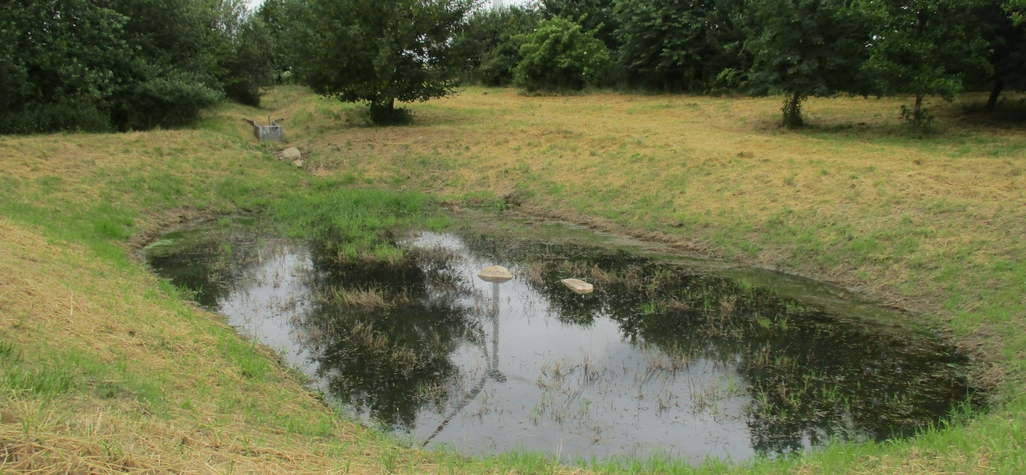
Detention ponds are artificially excavated basins that collect stormwater runoff and eroded sediment from the upstream catchment. The water stored in these ponds is slowly released into a water body or it infiltrates into the groundwater – or both. Their primary functions are flood control, erosion control and water quality improvement.
2.2 การอธิบายแบบละเอียดของเทคโนโลยี
คำอธิบาย:
This documentation focuses on a detention basin constructed to hold surface runoff at the lowest point of an agricultural catchment. A well-designed detention pond is an effective flood control and landscape management measure. It stores surface runoff and releases it through controlled flow, infiltration, or evaporation (or a combination), and reduces nutrient inputs to the adjacent water body by filtering out sediment and nutrients through particle deposition, or nutrient uptake by plants. On average, water treatment in a detention pond can remove about 50-60% of suspended solids, 30-35% of total phosphorus and total nitrogen, and 25-65% of metals. Ponds also provide habitat for terrestrial, riparian and aquatic species. In addition to their ecological impact, they have an aesthetic and cultural value to society, for example, as a demonstration of effective sustainable water management.
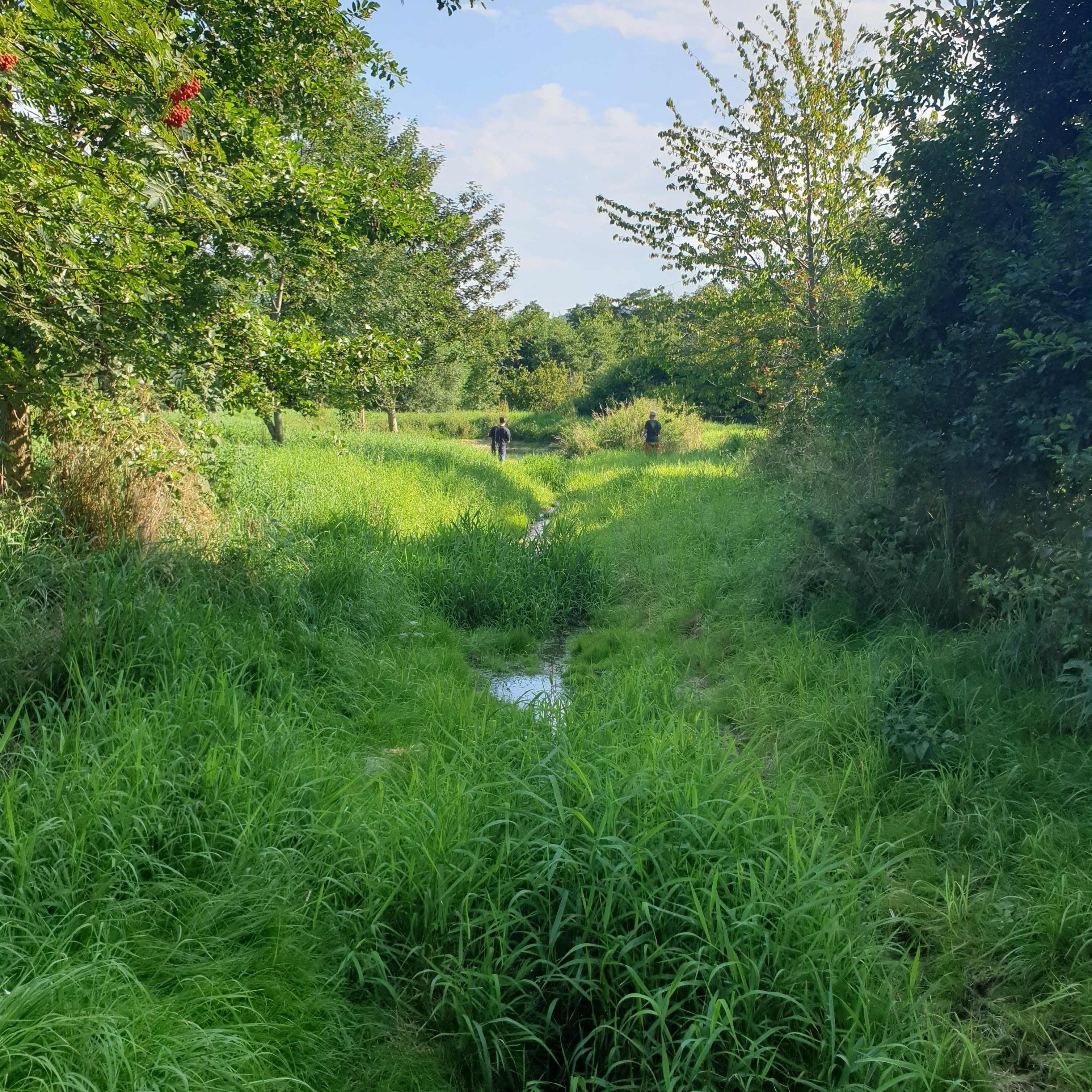
The detention basin described here was constructed by excavating a new depression and ditch system. It consists of a 450 m long inlet channel, a 250 m² pond, and an overflow channel that diverts excess water downstream to the nearest river (Schwarzer Schöps). However, there are no outlet structures for draining water that is captured in the pond (apart from the overflow). All the collected water seeps into the ground and soil particles settle. As a general rule, the size of such a pond should be 3-7% of the upstream catchment and should be able to hold at least the precipitation of a 1 in 30 year rainfall event. However, as the infiltration of the collected water is rather slow, the efficiency is reduced for successive events and overflowing is common. The depth should be between 1.2 m and 2.0 m. A deeper pond can lead to stratification and anoxic conditions, while a shallower pond may cause algal blooms and high biological activity in the summer. Water stored in the pond should remain for at least 20 days to ensure biological treatment.
The construction of the detention pond in this documentation was initiated as a compensation and replacement measure for the construction of a new road in 2016. Accordingly, the road construction authority, the landscape conservation association and a farmer were involved in the implementation.
As usual with such measures there are drawbacks as well as positive impact for landowners. The measure consumes a lot of land, which automatically results in yield losses. It is expensive to build and not easy to construct - and requires the help of an engineering firm while also being time-consuming to maintain. Maintenance is required to sustain the benefits of the technology. For a pond such as that documented here, the following maintenance activities are necessary: during the first three years, maintenance includes mowing the surrounding green area and the dried out pond and channel three times per year. After the fourth year, maintenance includes (a) an annual function check, (b) a check for pest infestation every two years, and (c) suppression of excess woody growth every eight to ten years. Twice a year (mid-June and late August), the grass around the pond and in the intake channel is mowed and the clippings are removed. Shrubs and woody plants are maintained, especially by pruning woody plants (every 8 to 10 years) and coppicing sections of shrubs (every 10 to 15 years). In the long term, it may be necessary to remove the deposited sediments in order to maintain the retention capacity.
2.3 รูปภาพของเทคโนโลยี
อัลบั้มสื่อบันทึก
2.5 ประเทศภูมิภาค หรือสถานที่ตั้งที่เทคโนโลยีได้นำไปใช้และได้รับการครอบคลุมโดยการประเมินนี้
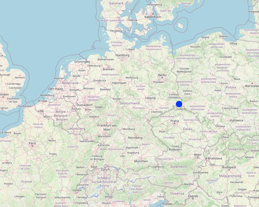
ประเทศ:
เยอรมนี
ภูมิภาค/รัฐ/จังหวัด:
Saxony
ข้อมูลจำเพาะเพิ่มเติมของสถานที่ตั้ง :
Reichenbach
ระบุการกระจายตัวของเทคโนโลยี:
- ใช้ ณ จุดที่เฉพาะเจาะจงหรือเน้นไปยังบริเวณพื้นที่ขนาดเล็ก
Is/are the technology site(s) located in a permanently protected area?
ไม่ใช่
Map
×2.6 วันที่การดำเนินการ
ถ้าไม่รู้ปีที่แน่นอน ให้ระบุวันที่โดยประมาณ:
- 10-50 ปี
2.7 คำแนะนำของเทคโนโลยี
- Compensation measure
ความคิดเห็น (ประเภทของโครงการ เป็นต้น) :
The construction of the detention pond was initiated as a compensation measure for the construction for the road construction project "S70 OU Reichenbach 2. BA".
3. การจัดประเภทของเทคโนโลยี SLM
3.1 วัตถุประสงค์หลักของเทคโนโลยี
- ลด ป้องกัน ฟื้นฟู การเสื่อมโทรมของที่ดิน
- อนุรักษ์ระบบนิเวศน์
- ป้องกันพื้นที่ลุ่มน้ำ/บริเวณท้ายน้ำ โดยร่วมกับเทคโนโลยีอื่นๆ
- ลดความเสี่ยงของภัยพิบัติ
- สร้างผลกระทบทางด้านสังคมที่เป็นประโยชน์
3.2 ประเภทของการใช้ที่ดินในปัจจุบันที่ได้นำเทคโนโลยีไปใช้
Land use mixed within the same land unit:
ไม่ใช่

อื่น ๆ
ระบุ:
extensively farmed grassland
3.3 Has land use changed due to the implementation of the Technology?
Has land use changed due to the implementation of the Technology?
- No (Continue with question 3.4)
3.4 การใช้น้ำ
การใช้น้ำของที่ดินที่มีการใช้เทคโนโลยีอยู่:
- จากน้ำฝน
3.5 กลุ่ม SLM ที่ตรงกับเทคโนโลยีนี้
- การเก็บเกี่ยวน้ำ
- การลดความเสี่ยงจากภัยพิบัติบนพื้นฐานของระบบนิเวศ
3.6 มาตรการ SLM ที่ประกอบกันเป็นเทคโนโลยี

มาตรการอนุรักษ์ด้วยโครงสร้าง
- S5: เขื่อน ชั้นดินที่แน่นแข็งบ่อน้ำ
3.7 รูปแบบหลักของการเสื่อมโทรมของที่ดินที่ได้รับการแก้ไขโดยเทคโนโลยี

การกัดกร่อนของดินโดยน้ำ
- Wt (Loss of topsoil): การสูญเสียดินชั้นบนหรือการกัดกร่อนที่ผิวดิน
- Wg (Gully erosion): การกัดกร่อนแบบร่องธารหรือการทำให้เกิดร่องน้ำเซาะ

การเสื่อมโทรมของน้ำ
- Hs (Change in quantity of surface water): การเปลี่ยนแปลงปริมาณของน้ำที่ผิวดิน
- Hg (Change in groundwater): การเปลี่ยนแปลงของน้ำบาดาลหรือระดับน้ำในแอ่งน้ำบาดาล
3.8 การป้องกัน การลดลง หรือการฟื้นฟูความเสื่อมโทรมของที่ดิน
ระบุเป้าหมายของเทคโนโลยีกับความเสื่อมโทรมของที่ดิน:
- ลดความเสื่อมโทรมของดิน
- ฟื้นฟูบำบัดที่ดินที่เสื่อมโทรมลงอย่างมาก
4. ข้อมูลจำเพาะด้านเทคนิค กิจกรรมการนำไปปฏิบัติใช้ ปัจจัยนำเข้า และค่าใช้จ่าย
4.1 แบบแปลนทางเทคนิคของเทคโนโลยี

ข้อมูลจำเพาะด้านเทคนิค (แบบแปลนทางเทคนิคของเทคโนโลยี):
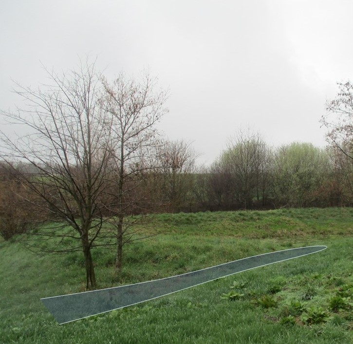
Securing dam stability by willow sticks.
ผู้เขียน:
LISt Gesellschaft für Verkehrswesen und ingenieurtechnische Dienstleistungen mbH, Bereich Kompensationsmaßnahmenmanagement
วันที่:
29/02/2016

ข้อมูลจำเพาะด้านเทคนิค (แบบแปลนทางเทคนิคของเทคโนโลยี):
A detention pond (in genreral) consists of a sediment forebay (pretreatment system), a permanent pool that is intended to remain wet throughout the year (but may dry out), a temporary storage pond for flood attenuation, and a shallow zone or aquatic bench along the edge of the permanent pool to support wetland planting that provides ecological and safety benefits. It should be wedge-shaped with a length to width ratio of between 3:1 and 5:1. The side slope shouldn’t be steeper than 1:3 for public safety and maintenance access.
ผู้เขียน:
Hunt et al. (2020)
วันที่:
20/02/2020
4.2 ข้อมูลทั่วไปเกี่ยวกับการคำนวณปัจจัยนำเข้าและค่าใช้จ่าย
ให้ระบุว่าค่าใช้จ่ายและปัจจัยนำเข้าได้รับการคำนวณอย่างไร:
- ต่อหน่วยเทคโนโลยี
โปรดระบุหน่วย:
Detention pond (as documented here)
Specify dimensions of unit (if relevant):
225 m², ca. 337,5 m³ (water depth of 1,5m)
อื่นๆ หรือสกุลเงินประจำชาติ (ระบุ):
€
If relevant, indicate exchange rate from USD to local currency (e.g. 1 USD = 79.9 Brazilian Real): 1 USD =:
0.91
ระบุค่าเฉลี่ยของค่าจ้างในการจ้างแรงงานต่อวัน:
18.70 € per hour
4.3 กิจกรรมเพื่อการจัดตั้ง
| กิจกรรม | Timing (season) | |
|---|---|---|
| 1. | remove topsoil | |
| 2. | profile water body according to site plan (Standing water 1.5 m deep, ditch 0.5-1.5m deep) | |
| 3. | installing of inlet channel | |
| 4. | installing erosion protection on embankments | |
| 5. | cover the topsoil / terrain profiling | |
| 6. | planting of shrubs & aquatic plants along the shoreline | |
| 7. | ditch connection to Schwarzer-Schöps | |
| 8. | reprofiling ditches (90m) | |
| 9. | desilting of drainage ditch to Schwarzer-Schöps | |
| 10. | subsequent installation of a spillway (beak structure: 'Schnabelbauwerk') and willow sticks as an erosion control measure for the ditch connection to Schwarzer-Schöps. |
4.4 ค่าใช้จ่ายของปัจจัยนำเข้าที่จำเป็นสำหรับการจัดตั้ง
If you are unable to break down the costs in the table above, give an estimation of the total costs of establishing the Technology:
25250.0
ถ้าผู้ใช้ที่ดินรับภาระน้อยกว่า 100% ของค่าใช้จ่าย ให้ระบุว่าใครเป็นผู้รับผิดชอบส่วนที่เหลือ:
The costs were covered by the road construction authority (compensation measure for the construction of a new road)
แสดงความคิดเห็น:
based on estimated average costs (nwrm.eu)
4.5 การบำรุงรักษาสภาพหรือกิจกรรมที่เกิดขึ้นเป็นประจำ
| กิจกรรม | ช่วงระยะเวลา/ความถี่ | |
|---|---|---|
| 1. | completion and development maintenance (mowing of the green area and the water-free water body) | first three years: three times per year |
| 2. | functional check | after the fourth year: every year |
| 3. | check for pest infestation | after the fourth year : every other year |
| 4. | check to suppress unwanted woody growth | after the fourth year: every 8 to 10 years |
| 5. | grass around the pond and in the intake channel is mowed and the clippings are removed | after the fourth year: twice a year (mid-June and late August) |
| 6. | pruning woody plants | every 8 to 10 years |
| 7. | putting sections of shrubs on stock | every 10 to 15 years |
4.6 ค่าใช้จ่ายของปัจจัยนำเข้าและกิจกรรมที่เกิดขึ้นเป็นประจำที่ต้องการการบำรุงรักษา (ต่อปี)
If you are unable to break down the costs in the table above, give an estimation of the total costs of maintaining the Technology:
618.0
ถ้าผู้ใช้ที่ดินรับภาระน้อยกว่า 100% ของค่าใช้จ่าย ให้ระบุว่าใครเป็นผู้รับผิดชอบส่วนที่เหลือ:
The costs are covered by the road construction authority (compensation measure for the construction of a new road)
แสดงความคิดเห็น:
estimated average costs (nwrm.eu)
4.7 ปัจจัยสำคัญที่สุดที่มีผลกระทบต่อค่าใช้จ่าย
ปัจจัยสำคัญที่สุดที่มีผลกระทบต่อค่าใช้จ่ายต่างๆ:
From the government perspective: A budget must be set aside annually for necessary maintenance to ensure functional efficiency.
5. สิ่งแวดล้อมทางธรรมชาติและของมนุษย์
5.1 ภูมิอากาศ
ฝนประจำปี
- < 250 ม.ม.
- 251-500 ม.ม.
- 501-750 ม.ม.
- 751-1,000 ม.ม.
- 1,001-1,500 ม.ม.
- 1,501-2,000 ม.ม.
- 2,001-3,000 ม.ม.
- 3,001-4,000 ม.ม.
- > 4,000 ม.ม.
ข้อมูลจำเพาะ/ความคิดเห็นเรื่องปริมาณน้ำฝน:
Average annual rainfall in mm: 750.82 mm/a
Name of the meteorological station: https://whh-kliwes.de/mapview
เขตภูมิอากาศเกษตร
- กึ่งชุ่มชื้น
Length of growing period (LGP): 209 days
(https://www.umwelt.sachsen.de/dauer-der-vegetationsperiode-30631.html)
5.2 สภาพภูมิประเทศ
ค่าเฉลี่ยความลาดชัน:
- ราบเรียบ (0-2%)
- ลาดที่ไม่ชัน (3-5%)
- ปานกลาง (6-10%)
- เป็นลูกคลื่น (11-15%)
- เป็นเนิน (16-30%)
- ชัน (31-60%)
- ชันมาก (>60%)
ธรณีสัณฐาน:
- ที่ราบสูง/ที่ราบ
- สันเขา
- ไหล่เขา
- ไหล่เนินเขา
- ตีนเนิน
- หุบเขา
ระดับความสูง:
- 0-100 เมตร
- 101-500 เมตร
- 501-1,000 เมตร
- 1,001-1,500 เมตร
- 1,501-2,000 เมตร
- 2,001-2,500 เมตร
- 2,501-3,000 เมตร
- 3,001-4,000 เมตร
- > 4,000 เมตร
ให้ระบุถ้าเทคโนโลยีได้ถูกนำไปใช้:
- บริเวณแอ่งบนที่ราบ (concave situations)
5.3 ดิน
ค่าเฉลี่ยความลึกของดิน:
- ตื้นมาก (0-20 ซ.ม.)
- ตื้น (21-50 ซ.ม.)
- ลึกปานกลาง (51-80 ซ.ม.)
- ลึก (81-120 ซ.ม.)
- ลึกมาก (>120 ซ.ม.)
เนื้อดิน (ดินชั้นบน):
- หยาบ/เบา (ดินทราย)
- ปานกลาง (ดินร่วน ทรายแป้ง)
เนื้อดินล่าง (> 20 ซ.ม.ต่ำจากผิวดิน):
- ปานกลาง (ดินร่วน ทรายแป้ง)
อินทรียวัตถุในดิน:
- สูง (>3%)
(ถ้ามี) ให้แนบคำอธิบายเรื่องดินแบบเต็มหรือระบุข้อมูลที่มีอยู่ เช่น ชนิดของดิน ค่า pH ของดินหรือความเป็นกรดของดิน ความสามารถในการแลกเปลี่ยนประจุบวก ไนโตรเจน ความเค็ม เป็นต้น:
Luvisol (German soil classification system: Parabraunerde)
5.4 ความเป็นประโยชน์และคุณภาพของน้ำ
ระดับน้ำใต้ดิน:
<5 เมตร
น้ำไหลบ่าที่ผิวดิน:
ไม่ดีหรือไม่มีเลย
คุณภาพน้ำ (ที่ยังไม่ได้บำบัด):
เป็นน้ำเพื่อการดื่มที่ไม่ดี (จำเป็นต้องได้รับการบำบัด)
Water quality refers to:
surface water
ความเค็มของน้ำเป็นปัญหาหรือไม่:
ไม่ใช่
กำลังเกิดน้ำท่วมในพื้นที่หรือไม่:
ไม่ใช่
5.5 ความหลากหลายทางชีวภาพ
ความหลากหลายทางชนิดพันธุ์:
- ปานกลาง
ความหลากหลายของแหล่งที่อยู่:
- สูง
5.6 ลักษณะของผู้ใช้ที่ดินที่นำเทคโนโลยีไปปฏิบัติใช้
อยู่กับที่หรือเร่ร่อน:
- อยู่กับที่
รายได้ที่มาจากนอกฟาร์ม:
- < 10% ของรายได้ทั้งหมด
ระดับของความมั่งคั่งโดยเปรียบเทียบ:
- รวย
เป็นรายบุคคล/ครัวเรือน:
- กลุ่ม/ชุมชน
- ลูกจ้าง (บริษัท รัฐบาล)
ระดับของการใช้เครื่องจักรกล:
- การใช้เครื่องจักรหรือเครื่องยนต์
เพศ:
- หญิง
- ชาย
อายุของผู้ใช้ที่ดิน:
- วัยกลางคน
5.7 Average area of land used by land users applying the Technology
- < 0.5 เฮกตาร์
- 0.5-1 เฮกตาร์
- 1-2 เฮกตาร์
- 2-5 เฮกตาร์
- 5-15 เฮกตาร์
- 15-50 เฮกตาร์
- 50-100 เฮกตาร์
- 100-500 เฮกตาร์
- 500-1,000 เฮกตาร์
- 1,000-10,000 เฮกตาร์
- >10,000 เฮกตาร์
แสดงความคิดเห็น:
The technology was not built and is not maintained by a land user, but by a public authority (road construction authority).
5.8 กรรมสิทธิ์ในที่ดิน สิทธิในการใช้ที่ดินและสิทธิในการใช้น้ำ
กรรมสิทธิ์ในที่ดิน:
- รัฐ
สิทธิในการใช้ที่ดิน:
- รายบุคคล
สิทธิในการใช้น้ำ:
- เกี่ยวกับชุมชน (ถูกจัดระเบียบ)
Are land use rights based on a traditional legal system?
ไม่ใช่
5.9 การเข้าถึงบริการและโครงสร้างพื้นฐาน
สุขภาพ:
- จน
- ปานกลาง
- ดี
การศึกษา:
- จน
- ปานกลาง
- ดี
ความช่วยเหลือทางด้านเทคนิค:
- จน
- ปานกลาง
- ดี
การจ้างงาน (เช่น ภายนอกฟาร์ม):
- จน
- ปานกลาง
- ดี
ตลาด:
- จน
- ปานกลาง
- ดี
พลังงาน:
- จน
- ปานกลาง
- ดี
ถนนและการขนส่ง:
- จน
- ปานกลาง
- ดี
น้ำดื่มและการสุขาภิบาล:
- จน
- ปานกลาง
- ดี
บริการด้านการเงิน:
- จน
- ปานกลาง
- ดี
6. ผลกระทบและสรุปคำบอกกล่าว
6.1 ผลกระทบในพื้นที่ดำเนินการ (On-site) จากการใช้เทคโนโลยี
ผลกระทบทางด้านเศรษฐกิจและสังคม
ความเป็นประโยชน์และคุณภาพของน้ำ
การมีน้ำไว้ให้สำหรับการชลประทาน
รายได้และค่าใช้จ่าย
ค่าใช่จ่ายของปัจจัยการผลิตทางการเกษตร
แสดงความคิดเห็น/ระบุ:
not on agricultural inputs, but establishment and maintenance consume a lot of money.
ภาระงาน
ผลกระทบด้านนิเวศวิทยา
วัฐจักรน้ำหรือน้ำบ่า
คุณภาพน้ำ
แสดงความคิดเห็น/ระบุ:
Improved water quality of subsequent river Schwarzer-Schöps.
การระบายน้ำส่วนเกิน
ดิน
ความชื้นในดิน
แสดงความคิดเห็น/ระบุ:
Soil moisture next to the retention pond increased due to infiltration.
ความหลากหลายทางชีวภาพของพืชและสัตว์
ความหลากหลายทางชีวภาพของพืช
แสดงความคิดเห็น/ระบุ:
More plant diversity compared to normal farmed grassland.
ความหลากหลายทางชีวภาพของสัตว์
ความหลากหลายของสัตว์
ลดความเสี่ยงของภัยพิบัติ
ผลกระทบจากน้ำท่วม
Specify assessment of on-site impacts (measurements):
The assessment is based on expert judgements. It is not based on on-site measurements.
6.2 ผลกระทบนอกพื้นที่ดำเนินการ (Off-site) จากการใช้เทคโนโลยี
น้ำที่ใช้ประโยชน์ได้
การเกิดมลพิษในน้ำบาดาลหรือแม่น้ำ
Specify assessment of off-site impacts (measurements):
The assessment is based on the expertise of the compilers and not on measurements in the case study.
6.3 การเผชิญและความตอบสนองของเทคโนโลยีต่อการเปลี่ยนแปลงสภาพภูมิอากาศที่ค่อยเป็นค่อยไป และสภาพรุนแรงของภูมิอากาศ / ภัยพิบัติ (ที่รับรู้ได้โดยผู้ใช้ที่ดิน)
การเปลี่ยนแปลงสภาพภูมิอากาศที่ค่อยเป็นค่อยไป
การเปลี่ยนแปลงสภาพภูมิอากาศที่ค่อยเป็นค่อยไป
| ฤดู | increase or decrease | เทคโนโลยีมีวิธีการรับมืออย่างไร | |
|---|---|---|---|
| ฝนประจำปี | ลดลง | ดี |
สภาพรุนแรงของภูมิอากาศ (ภัยพิบัติ)
ภัยพิบัติทางอุตุนิยมวิทยา
| เทคโนโลยีมีวิธีการรับมืออย่างไร | |
|---|---|
| พายุฝนประจำท้องถิ่น | ดีมาก |
ภัยพิบัติจากสภาพภูมิอากาศ
| เทคโนโลยีมีวิธีการรับมืออย่างไร | |
|---|---|
| คลื่นความร้อน | ดี |
แสดงความคิดเห็น:
In past summers there was little or no water left in the pond.
6.4 การวิเคราะห์ค่าใช้จ่ายและผลประโยชน์ที่ได้รับ
ผลประโยชน์ที่ได้รับเปรียบเทียบกับค่าใช้จ่ายในการจัดตั้งเป็นอย่างไร (จากมุมมองของผู้ใช้ที่ดิน)
ผลตอบแทนระยะสั้น:
ด้านลบอย่างมาก
ผลตอบแทนระยะยาว:
ด้านลบ
ผลประโยชน์ที่ได้รับเปรียบเทียบกับค่าใช้จ่ายในการบำรุงรักษาหรือต้นทุนที่เกิดขึ้นซ้ำอีก เป็นอย่างไร (จากมุมมองของผู้ใช้ที่ดิน)
ผลตอบแทนระยะสั้น:
ด้านลบเล็กน้อย
ผลตอบแทนระยะยาว:
เป็นกลางหรือสมดุล
6.5 การปรับตัวของเทคโนโลยี
- ครั้งเดียวหรือเป็นการทดลอง
6.6 การปรับตัว
เทคโนโลยีได้รับการปรับเปลี่ยนเมื่อเร็วๆนี้ เพื่อให้ปรับตัวเข้ากับสภาพที่กำลังเปลี่ยนแปลงหรือไม่:
ไม่ใช่
6.7 จุดแข็ง / ข้อได้เปรียบ / โอกาสของเทคโนโลยี
| จุดแข็ง / ข้อได้เปรียบ / โอกาสในทัศนคติของผู้ใช้ที่ดิน |
|---|
| temporary water-bearing habitat |
| biotopic network |
| buffer effect |
| จุดแข็ง / ข้อได้เปรียบ / โอกาสในทัศนคติของผู้รวบรวมหรือวิทยากรหลัก |
|---|
| effective flood control and landscape management measure |
| Stores surface runoff, slows it down, and releases it incrementally through controlled runoff, infiltration, or evaporation. Reduces nutrient inputs to adjacent water bodies. |
| aesthetic and cultural value for the society |
6.8 จุดอ่อน / ข้อเสียเปรียบ / ความเสี่ยงของเทคโนโลยีและวิธีการแก้ไข
| จุดอ่อน / ข้อเสียเปรียบ / ความเสี่ยงในทัศนคติของผู้ใช้ที่ดิน | มีวิธีการแก้ไขได้อย่างไร |
|---|---|
| Danger of siltation and succession if not maintained regularly and professionally. | |
| Difficult maintenance due to inaccessible terrain. |
| จุดอ่อน / ข้อเสียเปรียบ / ความเสี่ยงในทัศนคติของผู้รวบรวมหรือวิทยากรหลัก | มีวิธีการแก้ไขได้อย่างไร |
|---|---|
| Consumes a lot of land, which means a loss of yield. | |
| expensive to build and not easy to construct | |
| requires the help of an engineering firm | |
| time-consuming to maintain |
7. การอ้างอิงและการเชื่อมต่อ
7.1 วิธีการและแหล่งข้อมูล
- ไปเยี่ยมชมภาคสนาม การสำรวจพื้นที่ภาคสนาม
1
- การสัมภาษณ์กับผู้ใช้ที่ดิน
1
วันที่เก็บรวบรวมข้อมูล(ภาคสนาม) :
14/09/2021
7.3 Links to relevant online information
ชื่อเรื่องหรือคำอธิบาย:
Hunt et al. (2020): Plant Selection for Infiltrating Wet Ponds in North Carolina
URL:
https://content.ces.ncsu.edu/plant-selection-for-infiltrating-wet-ponds-in-north-carolina
ชื่อเรื่องหรือคำอธิบาย:
nwrm.eu: Individual NWRM, retention pond
URL:
http://nwrm.eu/index.php/measure/retention-ponds
ลิงก์และโมดูล
ขยายทั้งหมด ย่อทั้งหมดลิงก์
ไม่มีลิงก์
โมดูล
ไม่มีโมดูล