Technology of fastening Aral sea's drained bottom' s soil [Kazakhstan]
- Creation:
- Update:
- Compiler: Vladimir Kaverin
- Editor: –
- Reviewers: David Streiff, Alexandra Gavilano
no
technologies_1089 - Kazakhstan
View sections
Expand all Collapse all1. General information
1.2 Contact details of resource persons and institutions involved in the assessment and documentation of the Technology
SLM specialist:
Salimov Abdul
RGP, SPC of forest facility
Kazakhstan
Name of the institution(s) which facilitated the documentation/ evaluation of the Technology (if relevant)
SPC of Forest Facility (SPC of Forest Facility) - Kazakhstan1.3 Conditions regarding the use of data documented through WOCAT
The compiler and key resource person(s) accept the conditions regarding the use of data documented through WOCAT:
Yes
1.5 Reference to Questionnaire(s) on SLM Approaches (documented using WOCAT)
The approach of groove fastening sandy loam and … [Kazakhstan]
The approach of groove fastening sandy-loam and sandy soils of the Aral sea's drained bottom
- Compiler: Vladimir Kaverin
2. Description of the SLM Technology
2.1 Short description of the Technology
Definition of the Technology:
Technology of fastening Aral Sea's drained bottom's soil
2.2 Detailed description of the Technology
Description:
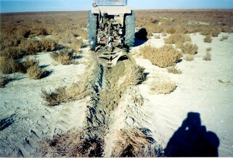
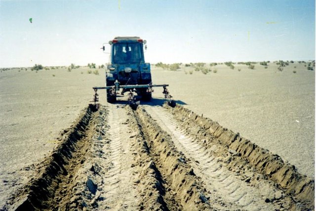
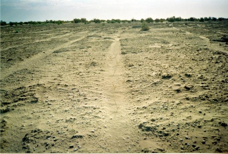
Planting of the saplings on the lots of the dried seabed of the Aral Sea was done in holes and uninterrupted furrows, which were formed by hands or cultivated KON – 2.8 PM . Depth of holes and furrows is 20-25 cm. Distance between holes was 1.5-2 m. Furrows were perpendicular to the prevailing winds (west-east) and placing mould in several options: 1 – moulds on both sides; 2 – the same from the southern side of a furrow; 3 – the same from the northern side. Furrows alternated with holes rows. Length of rows variants in repetition was 100 m. Saplings were filled up by hands or in rows in 1-2 meters, distance between rows was 2-2.5 meters. For the last 30 years Aral Sea level is falling and in 2001 it fell by 20 meters. More over 35 thousands sq. km of sea bottom came to the surface. Pace of falling during the last ten years is 0.9-0.8 meters per year according to the instrumental observations, that’s why area of dry land increases by 3-4 thousand sq. km annually.
Formation of moving sand dunes with the height of 2-5 meters, which move at the speed 20-30 meters per year in the southern and south-eastern direction, occurs on the area of more over 10 thousand sq. km. Width of dune ridges and ranges achieves 10-15 km and length up to 40-60 km. Ecosystems of brackish waste grounds lacking flora, difficult to traverse and dangerous were formed non the area 20 thousand sq. km of the former sea bottom. They are the source of dust-salt material to the major oasis agriculture in the delta of Syrdaria River.
2.3 Photos of the Technology
Media Gallery
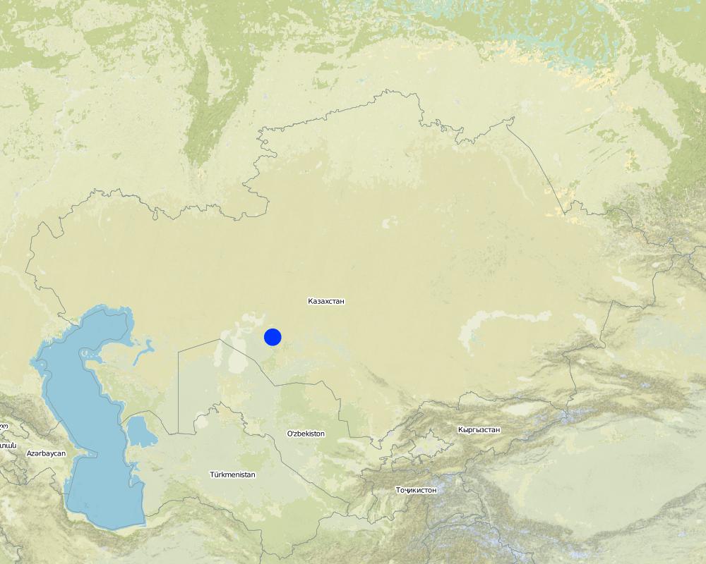
2.5 Country/ region/ locations where the Technology has been applied and which are covered by this assessment
Country:
Kazakhstan
Region/ State/ Province:
Kyzylorda
Further specification of location:
Kazalinsk state
Specify the spread of the Technology:
- evenly spread over an area
If the Technology is evenly spread over an area, specify area covered (in km2):
4.0
If precise area is not known, indicate approximate area covered:
- 1-10 km2
Comments:
Total area covered by the SLM Technology is 4 km2.
only 2% from 35000 sq.km of Aral sea's drained bottom
Map
×2.6 Date of implementation
If precise year is not known, indicate approximate date:
- less than 10 years ago (recently)
2.7 Introduction of the Technology
Specify how the Technology was introduced:
- during experiments/ research
Comments (type of project, etc.):
Was developed by kazakh - investigation institute of forest facility (1996-2001)
3. Classification of the SLM Technology
3.1 Main purpose(s) of the Technology
- reduce, prevent, restore land degradation
- conserve ecosystem
3.2 Current land use type(s) where the Technology is applied
Land use mixed within the same land unit:
Yes
Specify mixed land use (crops/ grazing/ trees):
- Silvo-pastoralism

Cropland
- Tree and shrub cropping
Number of growing seasons per year:
- 1
Specify:
Longest growing period in days: 208; Longest growing period from month to month: Apr - Oct

Grazing land
Extensive grazing:
- Nomadism

Forest/ woodlands
- (Semi-)natural forests/ woodlands
(Semi-)natural forests/ woodlands: Specify management type:
- Clear felling
- tugay forests and combseller
- Saxaul (cf. Haloxylon ammodendron)
Products and services:
- Fuelwood
- Grazing/ browsing
- Nature conservation/ protection
Comments:
Trees/ shrubs species: saxsaul, combseller
Major land use problems (compiler’s opinion): exudative salinization, forming of the salty ring on the surface, lov percent of natural overgroving.
Major land use problems (land users’ perception): rarely distribution of the bush-trees and presence of bared heathlands, which makes territory useful for land-use.
Grazingland comments: private sector of peasanting and farming predominate
Clear felling of (semi-)natural forests: stocking up for fuel, every year
Problems / comments regarding forest use: Degradation of saxaul and tugay forests in result of desertification processes: subsoil waters level reduction, deflation, poverty of population. Constant reorganization of forest facilities.
Forest products and services: fuelwood, grazing / browsing, nature conservation / protection
Type of grazing system comments: private sector of peasanting and farming predominate
Constraints of infrastructure network (roads, railways, pipe lines, power lines)
Constraints of wastelands / deserts / glaciers / swamps
3.4 Water supply
Water supply for the land on which the Technology is applied:
- rainfed
3.5 SLM group to which the Technology belongs
- improved ground/ vegetation cover
- ecosystem-based disaster risk reduction
3.6 SLM measures comprising the Technology

agronomic measures
- A1: Vegetation/ soil cover
- A4: Subsurface treatment

structural measures
Comments:
Secondary measures: structural measures
Type of agronomic measures: cover cropping, breaking compacted topsoil
Type of vegetative measures: aligned: -against wind
3.7 Main types of land degradation addressed by the Technology

soil erosion by wind
- Et: loss of topsoil
Comments:
Main type of degradation addressed: Et: loss of topsoil
Main causes of degradation: other human induced causes (specify) (agricultural causes - Excessive water-fence on an irrigation from the rivers Syrdarya and Amurdarya.)
Secondary causes of degradation: deforestation / removal of natural vegetation (incl. forest fires), other natural causes (avalanches, volcanic eruptions, mud flows, highly susceptible natural resources, extreme topography, etc.) specify (High wind activity in region (prevalence of winds with a speed up to 5 min/sec).)
3.8 Prevention, reduction, or restoration of land degradation
Specify the goal of the Technology with regard to land degradation:
- reduce land degradation
4. Technical specifications, implementation activities, inputs, and costs
4.1 Technical drawing of the Technology
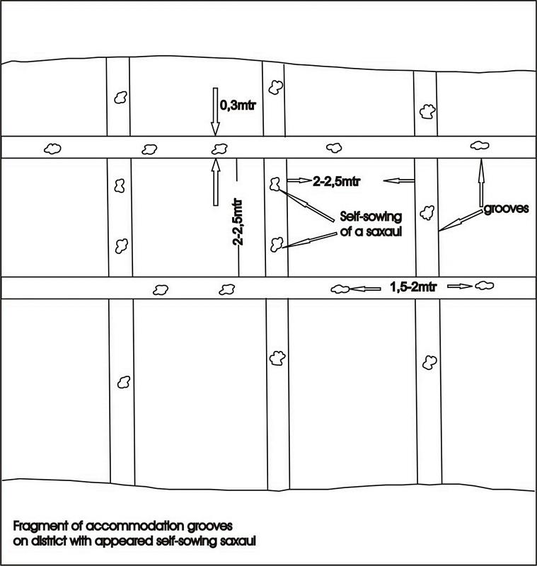
Technical specifications (related to technical drawing):
Fragment of accommodation grooves on district with appeared self-sowing saxaul
Technical knowledge required for field staff / advisors: low
Technical knowledge required for land users: low
Main technical functions: improvement of ground cover, increase of surface roughness, increase in organic matter, increase / maintain water stored in soil, sediment retention / trapping, sediment harvesting, improvement of soil structure
Cover cropping
Material/ species: saxsaul
Quantity/ density: 150
Remarks: protective planting
Breaking compacted topsoil
Remarks: breaking salturing up before planting by layout
Aligned: -against wind
Vegetative material: T : trees / shrubs
Number of plants per (ha): 150
Vertical interval between rows / strips / blocks (m): 1
Vertical interval within rows / strips / blocks (m): 1,5-2,0
Width within rows / strips / blocks (m): 30-35
Trees/ shrubs species: saxsaul, combseller
Structural measure: sediment sand / trap
Vertical interval between structures (m): 3
Spacing between structures (m): 2
Depth of ditches/pits/dams (m): 0,5
Width of ditches/pits/dams (m): 0,7
Length of ditches/pits/dams (m): 0,7
Height of bunds/banks/others (m): 0,5
Width of bunds/banks/others (m): 0,7
Length of bunds/banks/others (m): 100
Construction material (earth): fine-grained sand
Construction material (wood): saxsaul
4.2 General information regarding the calculation of inputs and costs
Specify currency used for cost calculations:
- USD
Indicate average wage cost of hired labour per day:
15.00
4.3 Establishment activities
| Activity | Timing (season) | |
|---|---|---|
| 1. | groove cutting | summer |
| 2. | slips planting | spring, autumn |
| 3. | groove cutting | summer |
| 4. | creating traps for sand | after planting |
4.4 Costs and inputs needed for establishment
| Specify input | Unit | Quantity | Costs per Unit | Total costs per input | % of costs borne by land users | |
|---|---|---|---|---|---|---|
| Labour | Traps for sand, cutting and planting | persons/day | 3.0 | 15.0 | 45.0 | 66.0 |
| Equipment | Others | ha | 1.0 | 20.0 | 20.0 | 29.0 |
| Plant material | Others | ha | 1.0 | 125.0 | 125.0 | 83.0 |
| Total costs for establishment of the Technology | 190.0 | |||||
| Total costs for establishment of the Technology in USD | 190.0 | |||||
Comments:
Duration of establishment phase: 12 month(s)
4.5 Maintenance/ recurrent activities
| Activity | Timing/ frequency | |
|---|---|---|
| 1. | groove cutting | spring, autumn / every year |
| 2. | slips planting | spring, autumn / every year |
4.6 Costs and inputs needed for maintenance/ recurrent activities (per year)
Comments:
saxsaul planting in the 100m * 100m. Sized beared heathlands due to enclosed SWC circuit
4.7 Most important factors affecting the costs
Describe the most determinate factors affecting the costs:
transportation of technique to the work place and gooves cutting
5. Natural and human environment
5.1 Climate
Annual rainfall
- < 250 mm
- 251-500 mm
- 501-750 mm
- 751-1,000 mm
- 1,001-1,500 mm
- 1,501-2,000 mm
- 2,001-3,000 mm
- 3,001-4,000 mm
- > 4,000 mm
Specifications/ comments on rainfall:
Average long-termed rainfall quantity makes 124 mm per year
Agro-climatic zone
- arid
Arid deserted
5.2 Topography
Slopes on average:
- flat (0-2%)
- gentle (3-5%)
- moderate (6-10%)
- rolling (11-15%)
- hilly (16-30%)
- steep (31-60%)
- very steep (>60%)
Landforms:
- plateau/plains
- ridges
- mountain slopes
- hill slopes
- footslopes
- valley floors
Altitudinal zone:
- 0-100 m a.s.l.
- 101-500 m a.s.l.
- 501-1,000 m a.s.l.
- 1,001-1,500 m a.s.l.
- 1,501-2,000 m a.s.l.
- 2,001-2,500 m a.s.l.
- 2,501-3,000 m a.s.l.
- 3,001-4,000 m a.s.l.
- > 4,000 m a.s.l.
Comments and further specifications on topography:
Landforms: Weak inclined primary -sea plain
Landforms: It is complicated with accumulative forms of colian relief
Altitudinal zone: 36 - 51 m a.s.l.
5.3 Soils
Soil depth on average:
- very shallow (0-20 cm)
- shallow (21-50 cm)
- moderately deep (51-80 cm)
- deep (81-120 cm)
- very deep (> 120 cm)
Soil texture (topsoil):
- coarse/ light (sandy)
- medium (loamy, silty)
Topsoil organic matter:
- low (<1%)
If available, attach full soil description or specify the available information, e.g. soil type, soil PH/ acidity, Cation Exchange Capacity, nitrogen, salinity etc.
Soil depth on average: Soils were not formed yet, horizons are absent
Topsoil organic matter: 0,19%-0,24%
Soil fertility is low with 0,24% of humus
Soil drainage / infiltration is poor in suclay, medium for clay and good loam-sandy and sandy soils
Soil water storage capacity is low - very low
5.6 Characteristics of land users applying the Technology
Market orientation of production system:
- mixed (subsistence/ commercial)
Off-farm income:
- less than 10% of all income
Relative level of wealth:
- very poor
- poor
Level of mechanization:
- manual work
- mechanized/ motorized
Indicate other relevant characteristics of the land users:
Population density: < 10 persons/km2
Annual population growth: negative
10% of the land users are average wealthy and own 60% of the land.
30% of the land users are poor and own 20% of the land.
60% of the land users are poor and own 20% of the land.
Off-farm income specification: catche fish grow vegetable - melon cultures and realizate them
Market orientation of production system: Firewood stocking and raise of forage capasity.
Level of mechanization: Using shovel for manual labour and tractor MTZ-30 for mechanised labour.
5.7 Average area of land used by land users applying the Technology
- < 0.5 ha
- 0.5-1 ha
- 1-2 ha
- 2-5 ha
- 5-15 ha
- 15-50 ha
- 50-100 ha
- 100-500 ha
- 500-1,000 ha
- 1,000-10,000 ha
- > 10,000 ha
Comments:
Also 2-5 ha
5.8 Land ownership, land use rights, and water use rights
Land ownership:
- state
Land use rights:
- communal (organized)
- individual
6. Impacts and concluding statements
6.1 On-site impacts the Technology has shown
Socio-economic impacts
Production
fodder production
Comments/ specify:
In adverse years
fodder quality
Comments/ specify:
In adverse years
Income and costs
farm income
Comments/ specify:
Exspenses for fuel decrease
Other socio-economic impacts
employment at farm
Comments/ specify:
Production increase
groove cuting tools
Comments/ specify:
High rent payment for technique
Socio-cultural impacts
community institutions
Comments/ specify:
Population's employment
SLM/ land degradation knowledge
Comments/ specify:
Ecological education
educational and cultural level of former members
Comments/ specify:
Native population's not understanding benefits of using SWC
Ecological impacts
Water cycle/ runoff
excess water drainage
Comments/ specify:
Humus accumulation
Soil
soil cover
Comments/ specify:
Salt removal of top horizons
soil loss
Quantity before SLM:
30
Quantity after SLM:
10
Comments/ specify:
Increase of kinds structure
Other ecological impacts
biodiversity
Comments/ specify:
Activity of wind stream decrease
soil fertility
Comments/ specify:
Avoidance of blowing
fuel supply
Comments/ specify:
4-5 hectare per year
6.2 Off-site impacts the Technology has shown
wind transported sediments
Comments/ specify:
Soil surface's erosion stop's
6.4 Cost-benefit analysis
How do the benefits compare with the establishment costs (from land users’ perspective)?
Long-term returns:
slightly positive
How do the benefits compare with the maintenance/ recurrent costs (from land users' perspective)?
Long-term returns:
slightly positive
6.5 Adoption of the Technology
- 1-10%
If available, quantify (no. of households and/ or area covered):
13 households covering 1 percent of stated area
Of all those who have adopted the Technology, how many did so spontaneously, i.e. without receiving any material incentives/ payments?
- 11-50%
Comments:
10 land user families have adopted the Technology with external material support
Comments on acceptance with external material support: survey results
3 land user families have adopted the Technology without any external material support
Comments on spontaneous adoption: survey results
There is a little trend towards spontaneous adoption of the Technology
Comments on adoption trend: small farmer's economical vell-being improves
6.7 Strengths/ advantages/ opportunities of the Technology
| Strengths/ advantages/ opportunities in the land user’s view |
|---|
|
forest territory are restoring How can they be sustained / enhanced? during saxaul communities life |
|
soil deflation's speed and temps decrease How can they be sustained / enhanced? during saxaul communities life |
|
microclimate conditions increase How can they be sustained / enhanced? during saxaul communities life |
| Strengths/ advantages/ opportunities in the compiler’s or other key resource person’s view |
|---|
|
forests area and output of fuel increase How can they be sustained / enhanced? during saxauls plantings life (40-50) years |
|
field-dust carrying out is prevented How can they be sustained / enhanced? during communities vitual activity |
|
environmental and sanitary-epidemiological contitions improves How can they be sustained / enhanced? during technology SWC existence |
|
Additional work places are created How can they be sustained / enhanced? in period technology SWC application |
6.8 Weaknesses/ disadvantages/ risks of the Technology and ways of overcoming them
| Weaknesses/ disadvantages/ risks in the land user’s view | How can they be overcome? |
|---|---|
| absence of enough qvantity of enough quantity of technique | by means of cooperative association of facilities |
| Weaknesses/ disadvantages/ risks in the compiler’s or other key resource person’s view | How can they be overcome? |
|---|---|
| high rent payment for technique | additional purchase of the mechanised means |
| Low interest of local social institutions | to pay big attention for ecological education |
7. References and links
7.1 Methods/ sources of information
7.2 References to available publications
Title, author, year, ISBN:
"to study process of overgroving and to develop offers on assistance to natural reneval of saxaul black on the grounds of Aral Sea's naked bottom"
Available from where? Costs?
RGP,SPC of forest facility. Kirov str.,58 city Schuchinsk, Akmola region
Links and modules
Expand all Collapse allLinks
The approach of groove fastening sandy loam and … [Kazakhstan]
The approach of groove fastening sandy-loam and sandy soils of the Aral sea's drained bottom
- Compiler: Vladimir Kaverin
Modules
No modules