Irrigation using shortened furrows and regulated use of mineral fertilizers [Uzbekistan]
- Creation:
- Update:
- Compiler: Oyture Anarbekov
- Editor: Hayot Ibrakhimov
- Reviewers: Alexandra Gavilano, Rima Mekdaschi Studer
Qisqa Oqariqli sugorish (in Uzbek)
technologies_1189 - Uzbekistan
- Full summary as PDF
- Full summary as PDF for print
- Full summary in the browser
- Full summary (unformatted)
- Полив по укороченным бороздам и регламентированное использование минеральных удобрений: Aug. 2, 2017 (inactive)
- Полив по укороченным бороздам и регламентированное использование минеральных удобрений: Aug. 22, 2019 (inactive)
- Irrigation using shortened furrows and regulated use of mineral fertilizers: Aug. 12, 2025 (public)
View sections
Expand all Collapse all1. General information
1.3 Conditions regarding the use of data documented through WOCAT
The compiler and key resource person(s) accept the conditions regarding the use of data documented through WOCAT:
Yes
2. Description of the SLM Technology
2.1 Short description of the Technology
Definition of the Technology:
A resource-saving irrigation technology for row crops using shortened furrows, which enables significant savings of irrigation water and improves the efficiency of mineral fertilizer use on irrigated land.
2.2 Detailed description of the Technology
Description:
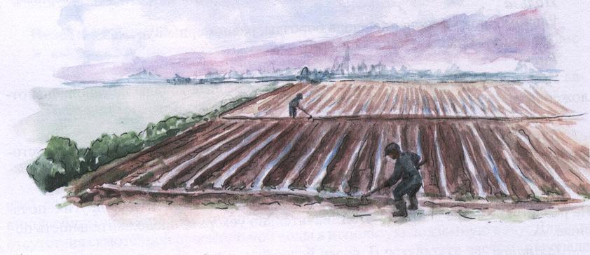
This technology is a simplest and low-cost method of irrigating row crops with regulated use of mineral fertilizers. It improves water and land use efficiency and is recommended for almost all row crops. Its distinctive features include:
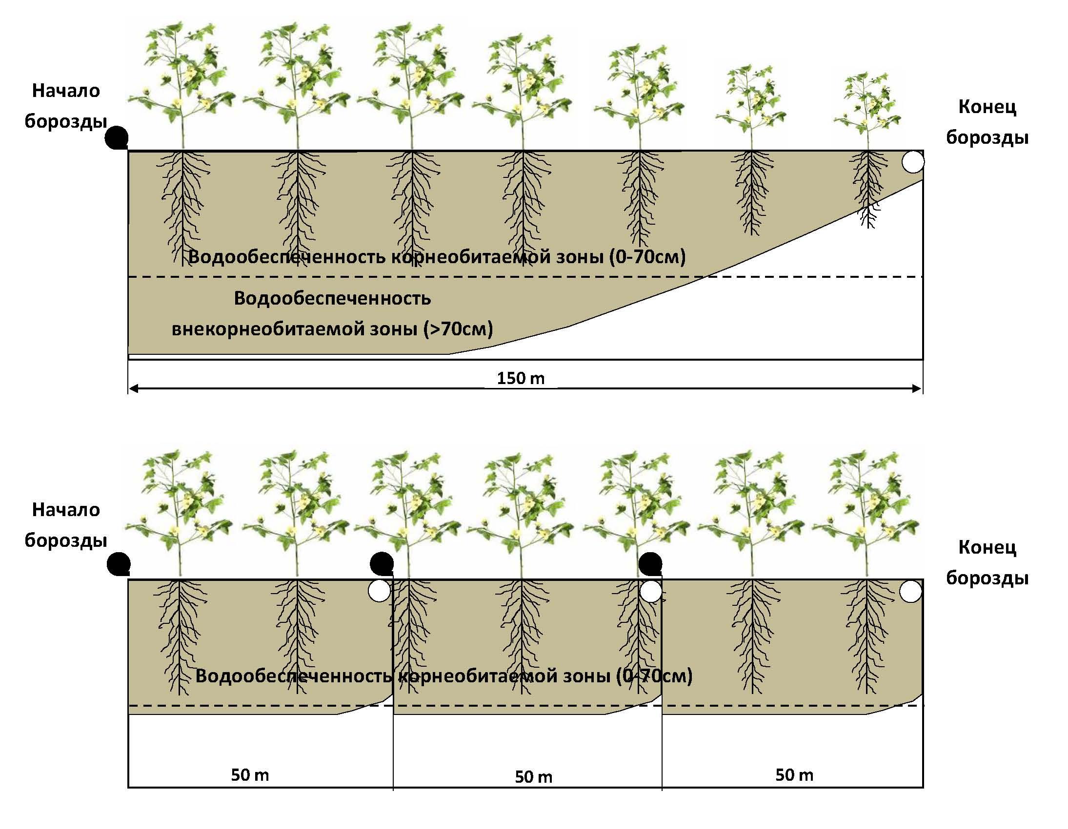
a) Shortened irrigation furrows – the length of furrows in this method depends on the leveling of the irrigated plot and the soil’s infiltration properties. On sandy loam soils (high infiltration), furrow length should not exceed 50 m; on light loamy soils – no more than 60 m; on medium loamy and heavier soils – no more than 70–80 m.
b) Timely and regulated water supply in line with the needs of the cultivated crop.
c) Uniform infiltration of irrigation water along the entire length of the shortened furrow.
d) Even soil moisture distribution across the irrigated plot, targeting only the root zone.
e) Efficient use of mineral fertilizers, preventing their leaching beyond the main root zone.
f) Uniform plant growth and development across the entire field within a shorter time frame.
g) Contribution to environmental protection and improvement of ecological conditions in irrigated agriculture.
This method is especially suitable for light, medium, and heavy loams, but can also be applied to other soil types. For gently sloping fields, the recommended technology shortens irrigation time without requiring adjustment of the supplied water volume. It is strongly recommended for row crops throughout areas where furrow irrigation is practiced in the arid and semi-arid regions of Central Asia.
Purpose of the technology: to ensure efficient use of irrigation water for conserving water resources, increasing the productivity of irrigated land, and improving the livelihoods of rural populations in arid zones.
Main activities and investments:
The proposed method is low-cost. Any additional costs such as the construction of auxiliary (interception) canals (“ok-aryks”) as in this case the irrigated furrow length does not exceed 50–70 m do not exceed 2,000–7,000 UZS (USD 1–3) per ha. Full application of mineral fertilizers to meet the planned yield level costs farmers USD 100–300 per ha. Optimization of crop nutrition is achieved through strict compliance with recommendations on the timing and rates of fertilizer application for the specific crop (the necessary fertilizers are purchased by the farmer).
Natural and social context:
The technology is intended for arable land located in semi-arid or arid zones. Recommended agronomic practices include cultivating gently sloping, well-leveled fields (without abrupt changes in relief) with moderate slopes, typically on light or medium loam soils where row crops with a shallow (30–70 cm) root zone are grown.
The technology is recommended for wide-scale adoption in agricultural production as a cost-effective and efficient approach under long-term irrigated land leases. While recommended for broad implementation, it is currently practiced mainly by experienced specialists.
2.3 Photos of the Technology
Media Gallery
2.5 Country/ region/ locations where the Technology has been applied and which are covered by this assessment
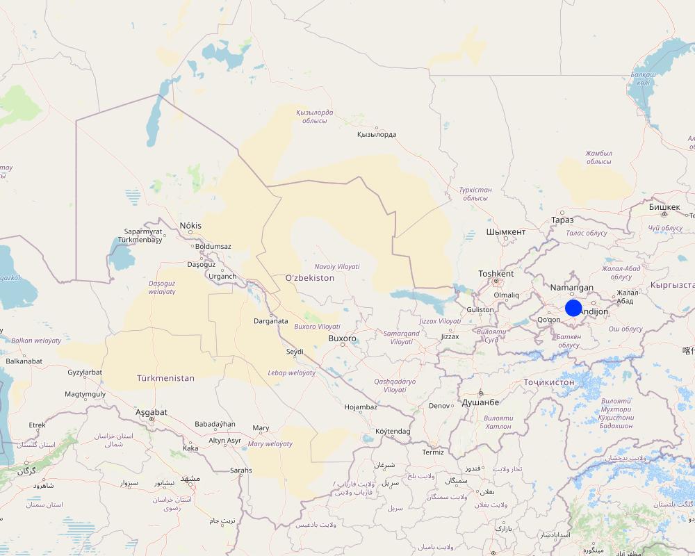
Country:
Uzbekistan
Region/ State/ Province:
Uzbekistan
Further specification of location:
Andijan and Fergana Region
Comments:
The total area where the technology is used is 1800 km2.
This technology is also relevant for other Central Asian countries. The technology was tested 1) In the Osh Region, Kyrgyzstan: within 50,000 hectares, 2) In the Sughd Region, Tajikistan: within 60,000 hectares.
The total area of technology distribution is given in hectares of cultivated area of row crops.
Map
×2.6 Date of implementation
If precise year is not known, indicate approximate date:
- less than 10 years ago (recently)
2.7 Introduction of the Technology
Specify how the Technology was introduced:
- during experiments/ research
3. Classification of the SLM Technology
3.2 Current land use type(s) where the Technology is applied

Cropland
- Annual cropping
Number of growing seasons per year:
- 1
Specify:
Vegetative period: 210 days. Vegetative period by months: April-October
Comments:
Main land use problems (according to the compiler):
An assessment of the actual efficiency of vegetative irrigation at the field level, carried out in five Central Asian countries, shows a low weighted average field efficiency of 21–40%. This means that a significant share of the irrigation water delivered to the field is used inefficiently. Gross irrigation norms substantially exceed the actual crop water requirements, with widespread losses due to surface runoff beyond the irrigated field, deep percolation losses beyond the root zone, and poor synchronization between crop water demand and actual irrigation schedules. Rational water use and water-saving measures could conserve a significant amount of water. The level of utilization of mineral fertilizers applied during the growing season is also low, with particularly high losses of nitrogen fertilizers in areas where furrow lengths are 150–200–250 meters or more, as their soluble forms are irreversibly leached from the root zone into groundwater.
Main land use problems (according to the land user):
The main land users are farmers, who in Uzbekistan currently lease irrigated land from the state for up to 49 years, with farm sizes typically ranging from 70 to 150 hectares. The main problem for farmers is insufficient supply of irrigation water to the tail-end sections of their farms. In this regard, the proposed technology helps save water, improve water use efficiency, and ensure that problematic areas receive sufficient irrigation water. All applied fertilizers (especially nitrogen) are fully utilized by the cultivated crops.
Land use after the introduction of the shortened furrow irrigation technology:
Agricultural field: Ca: cultivation of annual crops.
3.3 Has land use changed due to the implementation of the Technology?
Comments:
Land use after the introduction of the shortened furrow irrigation technology:
Agricultural field: Ca: cultivation of annual crops.
3.4 Water supply
Comments:
Water consumption: fully irrigated
3.6 SLM measures comprising the Technology

agronomic measures
- A3: Soil surface treatment
Comments:
Secondary activities: agronomic
Type of agronomic activities: shifting cropping, mineral (inorganic) fertilizers, furrows (drainage, irrigation)
3.7 Main types of land degradation addressed by the Technology

physical soil deterioration
- Pc: compaction
Comments:
Secondary types of degradation: Fu (Pc): compaction/compression/deterioration of soil structure
Main causes of degradation: land management (Unreasonably high irrigation rates and irreversible losses of soluble forms of mineral fertilizers)
Secondary causes of degradation: excessive extraction / over-absorption of water (for irrigation, industry, etc.) (Excessive withdrawal of water for irrigation), temperature changes (Low or high water years)
3.8 Prevention, reduction, or restoration of land degradation
Comments:
Primary objective: prevention of land degradation
Secondary objectives: rehabilitation/restoration of bare lands, prevention/reduction of degradation
4. Technical specifications, implementation activities, inputs, and costs
4.1 Technical drawing of the Technology
Technical specifications (related to technical drawing):
Required technical skills for workers: Medium (field staff and consultants should undergo training)
Required technical skills for land users: Medium
Main technical functions: Control of dispersed surface runoff – retention / capture
Secondary technical functions: Improve nutrient availability (supply, waste recycling, etc.); increase / maintain soil water retention
Crop rotation
Explanation: Annual crop rotation in the field (one year cotton, one year cereals)
Mineral (inorganic) fertilizers
Explanation: Apply nitrogen, phosphorus, and potassium fertilizers according to established standards
Furrows (drainage, irrigation)
Explanation: Cut during cotton planting
4.2 General information regarding the calculation of inputs and costs
other/ national currency (specify):
Uzbek soum
If relevant, indicate exchange rate from USD to local currency (e.g. 1 USD = 79.9 Brazilian Real): 1 USD =:
2203.0
Indicate average wage cost of hired labour per day:
7.00
4.4 Costs and inputs needed for establishment
Comments:
Creation time: 5 months
4.5 Maintenance/ recurrent activities
| Activity | Timing/ frequency | |
|---|---|---|
| 1. | Cutting furrows before irrigation | Beginning of April |
| 2. | Application of mineral fertilizers | Mid-April, if the rates are high then also in May and June |
4.6 Costs and inputs needed for maintenance/ recurrent activities (per year)
Comments:
Machinery/tools: tractor, furrow maker, fertilizer application unit
Nitrogen fertilizers should be applied fractionally - 30% at sowing (April), 35% during budding (June) and 35% during the flowering phase (July), phosphorus and potassium fertilizers should be applied in the fall. The above costs will only be incurred if the farmer does not apply enough mineral fertilizers recommended by the standards.
4.7 Most important factors affecting the costs
Describe the most determinate factors affecting the costs:
It is necessary to cut an additional transverse furrow (to discharge water to another irrigated area) so that the distance along the length of the irrigated area does not exceed 50-70-80 meters.
5. Natural and human environment
5.1 Climate
Annual rainfall
- < 250 mm
- 251-500 mm
- 501-750 mm
- 751-1,000 mm
- 1,001-1,500 mm
- 1,501-2,000 mm
- 2,001-3,000 mm
- 3,001-4,000 mm
- > 4,000 mm
Agro-climatic zone
- sub-humid
- arid
Thermal climate class: subtropical
5.2 Topography
Slopes on average:
- flat (0-2%)
- gentle (3-5%)
- moderate (6-10%)
- rolling (11-15%)
- hilly (16-30%)
- steep (31-60%)
- very steep (>60%)
Landforms:
- plateau/plains
- ridges
- mountain slopes
- hill slopes
- footslopes
- valley floors
Altitudinal zone:
- 0-100 m a.s.l.
- 101-500 m a.s.l.
- 501-1,000 m a.s.l.
- 1,001-1,500 m a.s.l.
- 1,501-2,000 m a.s.l.
- 2,001-2,500 m a.s.l.
- 2,501-3,000 m a.s.l.
- 3,001-4,000 m a.s.l.
- > 4,000 m a.s.l.
5.3 Soils
Soil depth on average:
- very shallow (0-20 cm)
- shallow (21-50 cm)
- moderately deep (51-80 cm)
- deep (81-120 cm)
- very deep (> 120 cm)
Soil texture (topsoil):
- medium (loamy, silty)
- fine/ heavy (clay)
Topsoil organic matter:
- medium (1-3%)
- low (<1%)
5.4 Water availability and quality
Ground water table:
< 5 m
Availability of surface water:
medium
Water quality (untreated):
for agricultural use only (irrigation)
5.5 Biodiversity
Species diversity:
- medium
5.6 Characteristics of land users applying the Technology
Market orientation of production system:
- commercial/ market
Off-farm income:
- less than 10% of all income
Relative level of wealth:
- poor
- average
Individuals or groups:
- individual/ household
Level of mechanization:
- mechanized/ motorized
Gender:
- men
Indicate other relevant characteristics of the land users:
Land users who use this technology are mostly average:
Population density: 200-500 people/km2
Annual population growth: 2% - 3%
2% of land users are of average income and own 3% of the land
2% of land users are poor and own 3% of the land
5.7 Average area of land used by land users applying the Technology
- < 0.5 ha
- 0.5-1 ha
- 1-2 ha
- 2-5 ha
- 5-15 ha
- 15-50 ha
- 50-100 ha
- 100-500 ha
- 500-1,000 ha
- 1,000-10,000 ha
- > 10,000 ha
Is this considered small-, medium- or large-scale (referring to local context)?
- medium-scale
5.8 Land ownership, land use rights, and water use rights
Land ownership:
- state
- communal/ village
Land use rights:
- leased
Water use rights:
- individual
5.9 Access to services and infrastructure
health:
- poor
- moderate
- good
education:
- poor
- moderate
- good
technical assistance:
- poor
- moderate
- good
employment (e.g. off-farm):
- poor
- moderate
- good
markets:
- poor
- moderate
- good
energy:
- poor
- moderate
- good
roads and transport:
- poor
- moderate
- good
drinking water and sanitation:
- poor
- moderate
- good
financial services:
- poor
- moderate
- good
6. Impacts and concluding statements
6.1 On-site impacts the Technology has shown
Socio-economic impacts
Production
crop production
Quantity before SLM:
2.0- 2.5 t/ha
Quantity after SLM:
3.0-3.5 t/ha
risk of production failure
Quantity before SLM:
?
Quantity after SLM:
?
product diversity
Income and costs
expenses on agricultural inputs
farm income
Socio-cultural impacts
food security/ self-sufficiency
conflict mitigation
situation of socially and economically disadvantaged groups
Ecological impacts
Water cycle/ runoff
water quantity
surface runoff
Soil
nutrient cycling/ recharge
6.2 Off-site impacts the Technology has shown
water availability
downstream siltation
6.3 Exposure and sensitivity of the Technology to gradual climate change and climate-related extremes/ disasters (as perceived by land users)
Gradual climate change
Gradual climate change
| Season | increase or decrease | How does the Technology cope with it? | |
|---|---|---|---|
| annual temperature | increase | well |
Climate-related extremes (disasters)
Meteorological disasters
| How does the Technology cope with it? | |
|---|---|
| local rainstorm | not known |
| local windstorm | not known |
Climatological disasters
| How does the Technology cope with it? | |
|---|---|
| drought | not well |
Hydrological disasters
| How does the Technology cope with it? | |
|---|---|
| general (river) flood | not known |
Other climate-related consequences
Other climate-related consequences
| How does the Technology cope with it? | |
|---|---|
| reduced growing period | not known |
6.4 Cost-benefit analysis
How do the benefits compare with the establishment costs (from land users’ perspective)?
Short-term returns:
positive
Long-term returns:
positive
How do the benefits compare with the maintenance/ recurrent costs (from land users' perspective)?
Short-term returns:
positive
Long-term returns:
positive
6.5 Adoption of the Technology
Comments:
5% of land user families use this technology without additional financial support
There is a tendency towards voluntary implementation of the technology
6.7 Strengths/ advantages/ opportunities of the Technology
| Strengths/ advantages/ opportunities in the compiler’s or other key resource person’s view |
|---|
|
Low-cost technology Can it be maintained or enhanced sustainability? Yes, for a long time |
|
Easily understandable technology that can be realistically implemented by the land user. How can sustainability be maintained or enhanced? For a long time. |
|
high return on investment, significant increase in yield How can sustainability be maintained or enhanced? For a long time. |
|
high efficiency and significant increase in agricultural producer income How can sustainability be maintained or enhanced? For a long time. |
| How can sustainability be maintained or enhanced? For a long time. |
6.8 Weaknesses/ disadvantages/ risks of the Technology and ways of overcoming them
| Weaknesses/ disadvantages/ risks in the compiler’s or other key resource person’s view | How can they be overcome? |
|---|---|
| НЕТ |
7. References and links
7.1 Methods/ sources of information
7.2 References to available publications
Title, author, year, ISBN:
Сборник материалов по проекту "Улучшение продуктивности воды на уровне поля". Сборник подготовлен специалистами группы НИЦ, МКВК и IWMI Центральная Азия. Ташкент 2013
Available from where? Costs?
НИЦ, МКВК и IWMI Центральная Азия
Links and modules
Expand all Collapse allLinks
No links
Modules
No modules