
Fanya Juu Terraces - Nappier grass+Swetpotatoes [Kenya]
- Creation:
- Update:
- Compiler: Paul Kahiga
- Editor: –
- Reviewers: Fabian Ottiger, Alexandra Gavilano
Fanya Juu Terraces - Nappier grass+Swetpotatoes
technologies_1243 - Kenya
View sections
Expand all Collapse all1. General information
1.2 Contact details of resource persons and institutions involved in the assessment and documentation of the Technology
Key resource person(s)
SLM specialist:
SLM specialist:
Gathenya Mwangi
Jomo Kenyatta University of Agriculture and Technology
Kenya
SLM specialist:
Home Patrick
Jomo Kenyatta University of Agriculture and Technology
Kenya
SLM specialist:
Chege Timothy
Jomo Kenyatta University of Agriculture and Technology
Kenya
SLM specialist:
Omwange Abamba
Jomo Kenyatta University of Agriculture and Technology
Kenya
SLM specialist:
Kimengich Baobab
Jomo Kenyatta University of Agriculture and Technology
Kenya
SLM specialist:
Wamuongo Jane
Kenya Agricultural Research Institute
Kenya
SLM specialist:
Karanja Andrew
Kenya Agricultural Research Institute
Kenya
SLM specialist:
Namirembe Sara
World Agroforestry Centre
Kenya
1.3 Conditions regarding the use of data documented through WOCAT
The compiler and key resource person(s) accept the conditions regarding the use of data documented through WOCAT:
Yes
1.4 Declaration on sustainability of the described Technology
Is the Technology described here problematic with regard to land degradation, so that it cannot be declared a sustainable land management technology?
No
2. Description of the SLM Technology
2.1 Short description of the Technology
Definition of the Technology:
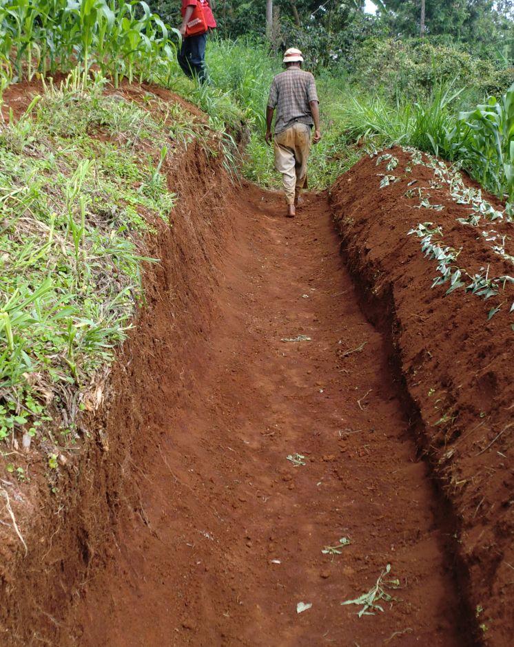
Fanya juu terraces stabilized with nappier grass and sweet potatoes are earth bunds created by digging a trench along a contour and throwing the soil up slope to form an embankment that is stabilized with nappier grass and during maintenance phase, the accumulated sediments are removed and thrown on the lower side and stabilized with sweet potatoes.
2.2 Detailed description of the Technology
Description:
The cross-sectional profile of a fanya juu terrace comprises an embankment to impound water, soil and nutrients, a storage area above the embankment to prevent overtopping by runoff and a berm or ledge to prevent the embankment soil from sliding bank into the trench. The trench below the embankment may or be retained. A Fanya juu terrace is often the first stage in the development of a bench terrace.
Purpose of the Technology: They effectively reduces slope-length, and hence soil erosion from steep croplands. In some cases, enlarged embankments are made to allow ponding of harvested runoff and, therefore, the structure can be used in water harvesting systems having external catchments. The soil bund retains water and thereby, safeguards yields even during droughts. In Embu County, farmers are very innovative. They ussually stabilize the up slope soil with nappier grass (fodder) and during the maintenance phase, the silt/sediments in the trench is scoped and thrown on the lower side where is stabilized with sweet potatoes vines.
Establishment / maintenance activities and inputs: The construction of fanya juu terraces is labor intensive and involves digging a trench on the contour and throwing the soil up slope to form an embankment. Construction is carried out after laying out pegs on the contour, or at a gradient, as required. A berm of 15cm to 30 cm is left to prevent the embankment soil up slope to form an embankment, which should be stabilized with grass. The excavated trench should be as narrow as possible to reduce wastage of cultivated land. Where the trench can be used for planting tree crops such as bananas, it should be wide enough to accommodate the crop. The embankment should be planted with perennial grass to stabilize it.
Natural / human environment: Fanya juu terraces are popular in smallholder farms particularly in semi arid areas where they are quite effective in conserving moisture and nutrients. They are applicable in areas where soils are too shallow for level bench terracing and on moderately steep slopes (e.g. below 20%) They are not suitable for stony soil. They normally develop into out ward sloping bench terraces after a few years depending on the amount of soil which moves down slope and lodges above the embankment.
2.3 Photos of the Technology
Media Gallery
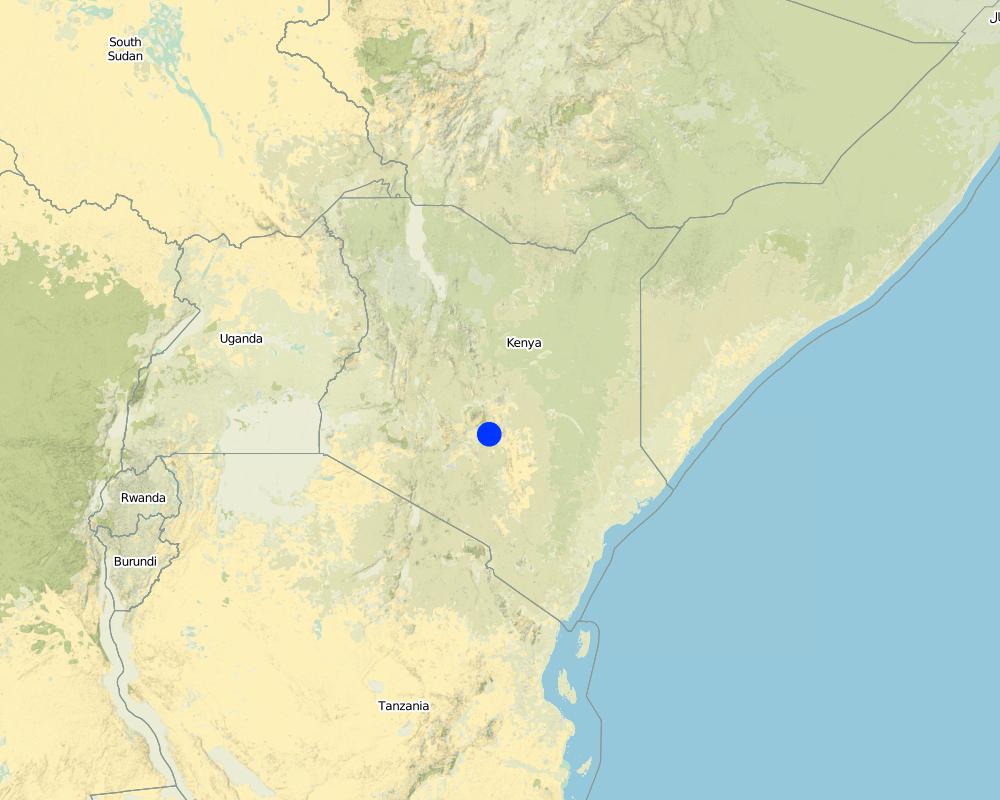
2.5 Country/ region/ locations where the Technology has been applied and which are covered by this assessment
Country:
Kenya
Region/ State/ Province:
Eastern Province
Further specification of location:
Mbere South District
Specify the spread of the Technology:
- evenly spread over an area
If precise area is not known, indicate approximate area covered:
- < 0.1 km2 (10 ha)
Map
×2.7 Introduction of the Technology
Specify how the Technology was introduced:
- through land users' innovation
3. Classification of the SLM Technology
3.1 Main purpose(s) of the Technology
- improve production
- reduce, prevent, restore land degradation
- create beneficial economic impact
3.2 Current land use type(s) where the Technology is applied

Cropland
- Annual cropping
Annual cropping - Specify crops:
- fodder crops - grasses
- root/tuber crops - sweet potatoes, yams, taro/cocoyam, other
Number of growing seasons per year:
- 1
Comments:
Major land use problems (compiler’s opinion): The technology is safe for soil erosion conservation
Major land use problems (land users’ perception): There has been a lot of erosion due to poor protective measures. But the technology has successively manged to curb the continued erosion
Future (final) land use (after implementation of SLM Technology): Cropland: Ca: Annual cropping
3.3 Has land use changed due to the implementation of the Technology?
Has land use changed due to the implementation of the Technology?
- No (Continue with question 3.4)
3.4 Water supply
Water supply for the land on which the Technology is applied:
- mixed rainfed-irrigated
3.5 SLM group to which the Technology belongs
- cross-slope measure
3.6 SLM measures comprising the Technology

structural measures
- S2: Bunds, banks
3.7 Main types of land degradation addressed by the Technology

soil erosion by water
- Wt: loss of topsoil/ surface erosion
Comments:
Main causes of degradation: soil management, Heavy / extreme rainfall (intensity/amounts), poverty / wealth
Secondary causes of degradation: labour availability
3.8 Prevention, reduction, or restoration of land degradation
Specify the goal of the Technology with regard to land degradation:
- prevent land degradation
- restore/ rehabilitate severely degraded land
4. Technical specifications, implementation activities, inputs, and costs
4.1 Technical drawing of the Technology
Technical specifications (related to technical drawing):
The technical drawing on the left hand side shows a typical fanya juu terrace stabilized with nappier grass on the upper slope and sweet potatoes vines on the lower down slope.
Location: Ena Location. Eastern Province
Date: 12.11.2012
Technical knowledge required for field staff / advisors: moderate (The extension officers need to demonstrate on how to construct the terraces)
Technical knowledge required for land users: high (The technology is good because it completely reduces soil losses)
Main technical functions: control of concentrated runoff: retain / trap
Author:
Paul Kahiga, 8444-00300 Nairobi Kenya
4.2 General information regarding the calculation of inputs and costs
other/ national currency (specify):
Kshs
If relevant, indicate exchange rate from USD to local currency (e.g. 1 USD = 79.9 Brazilian Real): 1 USD =:
100.0
Indicate average wage cost of hired labour per day:
5.00
4.3 Establishment activities
| Activity | Timing (season) | |
|---|---|---|
| 1. | Setting out the contours | Initial stages |
| 2. | Digging out the trench | After setting the contour |
| 3. | Planting nappier grass | on the up slope |
| 4. | Removing the sediments | maintenance phase |
| 5. | Planting of sweet potatoes | maintenance phase |
4.4 Costs and inputs needed for establishment
| Specify input | Unit | Quantity | Costs per Unit | Total costs per input | % of costs borne by land users | |
|---|---|---|---|---|---|---|
| Labour | Labour | ha | 1.0 | 200.0 | 200.0 | 100.0 |
| Equipment | Tools | ha | 1.0 | 25.0 | 25.0 | 100.0 |
| Other | Cuttings | ha | 1.0 | 30.0 | 30.0 | 100.0 |
| Total costs for establishment of the Technology | 255.0 | |||||
| Total costs for establishment of the Technology in USD | 2.55 | |||||
4.6 Costs and inputs needed for maintenance/ recurrent activities (per year)
| Specify input | Unit | Quantity | Costs per Unit | Total costs per input | % of costs borne by land users | |
|---|---|---|---|---|---|---|
| Labour | Labour | ha | 1.0 | 150.0 | 150.0 | 100.0 |
| Equipment | Tools | ha | 1.0 | 150.0 | 150.0 | 100.0 |
| Other | Cuttings | ha | 1.0 | 150.0 | 150.0 | 100.0 |
| Total costs for maintenance of the Technology | 450.0 | |||||
| Total costs for maintenance of the Technology in USD | 4.5 | |||||
Comments:
length of the structure
4.7 Most important factors affecting the costs
Describe the most determinate factors affecting the costs:
labour
5. Natural and human environment
5.1 Climate
Annual rainfall
- < 250 mm
- 251-500 mm
- 501-750 mm
- 751-1,000 mm
- 1,001-1,500 mm
- 1,501-2,000 mm
- 2,001-3,000 mm
- 3,001-4,000 mm
- > 4,000 mm
Agro-climatic zone
- sub-humid
Thermal climate class: subtropics
5.2 Topography
Slopes on average:
- flat (0-2%)
- gentle (3-5%)
- moderate (6-10%)
- rolling (11-15%)
- hilly (16-30%)
- steep (31-60%)
- very steep (>60%)
Landforms:
- plateau/plains
- ridges
- mountain slopes
- hill slopes
- footslopes
- valley floors
Altitudinal zone:
- 0-100 m a.s.l.
- 101-500 m a.s.l.
- 501-1,000 m a.s.l.
- 1,001-1,500 m a.s.l.
- 1,501-2,000 m a.s.l.
- 2,001-2,500 m a.s.l.
- 2,501-3,000 m a.s.l.
- 3,001-4,000 m a.s.l.
- > 4,000 m a.s.l.
5.3 Soils
Soil depth on average:
- very shallow (0-20 cm)
- shallow (21-50 cm)
- moderately deep (51-80 cm)
- deep (81-120 cm)
- very deep (> 120 cm)
Soil texture (topsoil):
- medium (loamy, silty)
Topsoil organic matter:
- medium (1-3%)
If available, attach full soil description or specify the available information, e.g. soil type, soil PH/ acidity, Cation Exchange Capacity, nitrogen, salinity etc.
Soil fertility: Medium
Soil drainage/infiltration: Good
Soil water storage capacity: Medium
5.4 Water availability and quality
Ground water table:
5-50 m
Availability of surface water:
good
Water quality (untreated):
good drinking water
5.5 Biodiversity
Species diversity:
- medium
5.6 Characteristics of land users applying the Technology
Market orientation of production system:
- mixed (subsistence/ commercial)
Off-farm income:
- less than 10% of all income
Relative level of wealth:
- average
Individuals or groups:
- individual/ household
Level of mechanization:
- manual work
Gender:
- women
- men
Indicate other relevant characteristics of the land users:
Land users applying the Technology are mainly common / average land users
Population density: < 10 persons/km2
Annual population growth: 0.5% - 1%
5.7 Average area of land used by land users applying the Technology
- < 0.5 ha
- 0.5-1 ha
- 1-2 ha
- 2-5 ha
- 5-15 ha
- 15-50 ha
- 50-100 ha
- 100-500 ha
- 500-1,000 ha
- 1,000-10,000 ha
- > 10,000 ha
Is this considered small-, medium- or large-scale (referring to local context)?
- small-scale
5.8 Land ownership, land use rights, and water use rights
Land ownership:
- individual, titled
Land use rights:
- individual
Water use rights:
- individual
5.9 Access to services and infrastructure
health:
- poor
- moderate
- good
education:
- poor
- moderate
- good
6. Impacts and concluding statements
6.1 On-site impacts the Technology has shown
Socio-economic impacts
Production
crop production
fodder production
land management
Income and costs
farm income
workload
Socio-cultural impacts
health situation
SLM/ land degradation knowledge
Ecological impacts
Water cycle/ runoff
harvesting/ collection of water
Soil
soil loss
Biodiversity: vegetation, animals
pest/ disease control
Quantity before SLM:
moles
Comments/ specify:
Moles
6.3 Exposure and sensitivity of the Technology to gradual climate change and climate-related extremes/ disasters (as perceived by land users)
Climate-related extremes (disasters)
Meteorological disasters
| How does the Technology cope with it? | |
|---|---|
| local rainstorm | well |
6.4 Cost-benefit analysis
How do the benefits compare with the establishment costs (from land users’ perspective)?
Short-term returns:
positive
Long-term returns:
positive
How do the benefits compare with the maintenance/ recurrent costs (from land users' perspective)?
Short-term returns:
positive
Long-term returns:
positive
6.5 Adoption of the Technology
Comments:
There is a moderate trend towards spontaneous adoption of the Technology
6.7 Strengths/ advantages/ opportunities of the Technology
| Strengths/ advantages/ opportunities in the compiler’s or other key resource person’s view |
|---|
| Fanya juu terraces stabilized with nappier grass prevents soil erosion by trapping and concentrating the runoff in the trenches. |
| They are source of nappier grass that is used for feeding farm animals. |
| They are source of food i.e. sweet potatoes. |
6.8 Weaknesses/ disadvantages/ risks of the Technology and ways of overcoming them
| Weaknesses/ disadvantages/ risks in the compiler’s or other key resource person’s view | How can they be overcome? |
|---|---|
| Danger of soil turning back in the trenches while harvesting the sweet potatoes. | Care should be taken to avoid the soil from falling back in the trenches. |
| Habitat for pest like moles that are very fond of sweet potatoes | Use of appropriate methods to eliminate the moles. |
7. References and links
7.1 Methods/ sources of information
- field visits, field surveys
- interviews with land users
When were the data compiled (in the field)?
18/09/2012
Links and modules
Expand all Collapse allLinks
No links
Modules
No modules