Seedling [Spain]
- Creation:
- Update:
- Compiler: Artemi Cerda
- Editor: –
- Reviewers: Fabian Ottiger, David Streiff, Alexandra Gavilano
Semillado
technologies_1266 - Spain
View sections
Expand all Collapse all1. General information
1.2 Contact details of resource persons and institutions involved in the assessment and documentation of the Technology
Key resource person(s)
SLM specialist:
SLM specialist:
1.3 Conditions regarding the use of data documented through WOCAT
The compiler and key resource person(s) accept the conditions regarding the use of data documented through WOCAT:
Yes
2. Description of the SLM Technology
2.1 Short description of the Technology
Definition of the Technology:
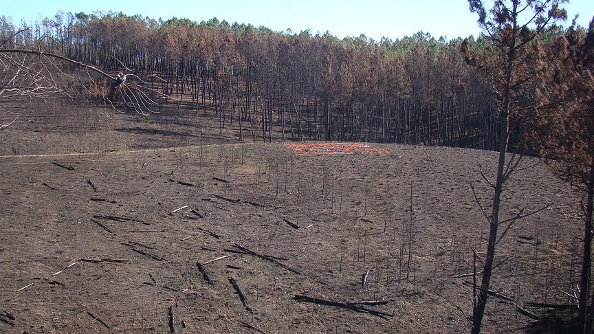
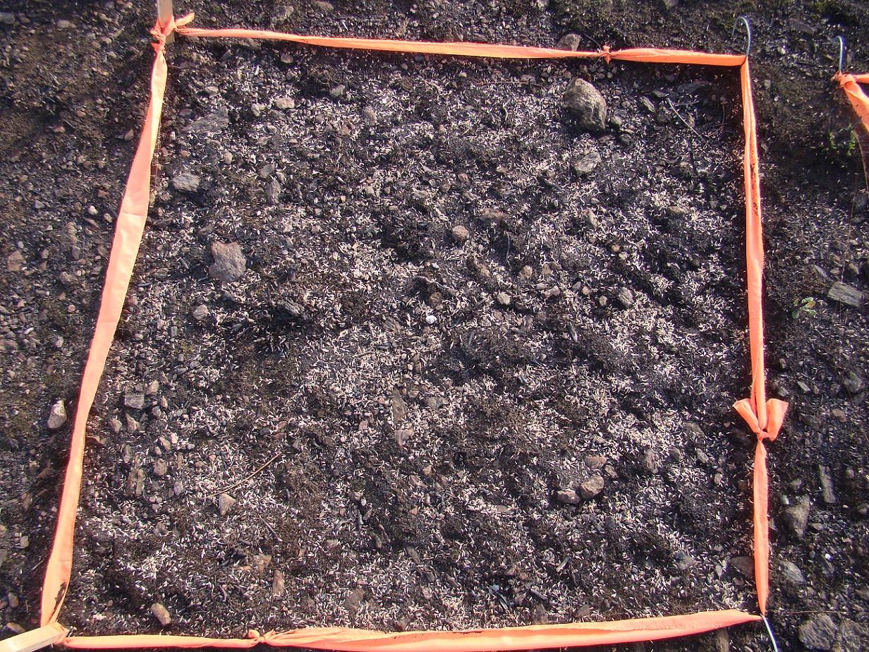
Based on post-fire assessment and in areas more prone to erosion, the seedlings will provide a short term soil cover that buffers the raindrop impact and decreases soil erosion.
2.2 Detailed description of the Technology
Description:
A wildfire is expected for the summer 2015 in the Caroig mountain range. The area was afforested by Aleppo pines during the 20th century and nowadays the landscape is composed of mature Aleppo pines at different stages of development and shrub vegetation in the understorey.
The research team of the University of Valencia will implement an experiment based on the seedling technique in order to reduce post-fire soil losses.
Purpose of the Technology: Seedlings in a post-fire environment will provide soil cover after the seed establishment, decreasing raindrops energy on soil surface and thus soil erosion.
Establishment / maintenance activities and inputs: The seeds will be obtained from greenhouse markets nearby (25 km) the research area. Festuca sp. will be used as the main species.
Natural / human environment: The Aleppo pine trees in the region are typically planted as mono-culture for wood production. The landscape reflects a long history of intense land management, with a mosaic of (semi-)natural and man-made agricultural (terraces) and afforested lands. Since the 1970´s, however, wildfires have increased dramatically in frequency and extent, driven primarily by socio-economic changes.
2.3 Photos of the Technology
Media Gallery
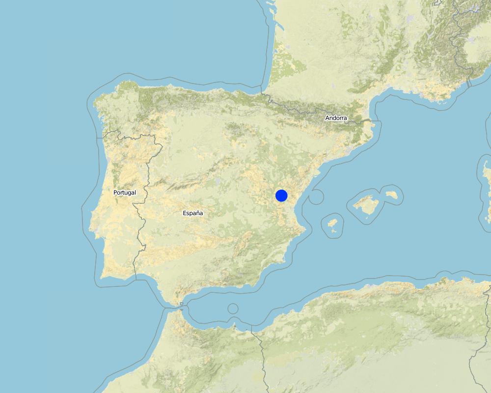
2.5 Country/ region/ locations where the Technology has been applied and which are covered by this assessment
Country:
Spain
Region/ State/ Province:
Spain
Further specification of location:
Valencia
Specify the spread of the Technology:
- evenly spread over an area
Map
×3. Classification of the SLM Technology
3.1 Main purpose(s) of the Technology
- reduce, prevent, restore land degradation
- adapt to climate change/ extremes and its impacts
- reduce impact of disasters
3.2 Current land use type(s) where the Technology is applied

Forest/ woodlands
- Tree plantation, afforestation
- Aleppo pines
Tree plantation, afforestation: Specify origin and composition of species:
- Monoculture local variety
Products and services:
- Timber
- Fuelwood
- Fruits and nuts
- Other forest products
- Grazing/ browsing
- Nature conservation/ protection
- Recreation/ tourism
- Protection against natural hazards
Comments:
Major land use problems (compiler’s opinion): In a post-fire environment, peak runoff and soil erosion rates are expected, resulting in a decrease of on-site fertility and derived off-site effects such as loss of water quality, reservoirs water volume storage, higher risk of flooding and harm to human beings.
Major land use problems (land users’ perception): Loss of wood resources.
3.4 Water supply
Water supply for the land on which the Technology is applied:
- rainfed
3.5 SLM group to which the Technology belongs
- improved ground/ vegetation cover
- ecosystem-based disaster risk reduction
3.6 SLM measures comprising the Technology

agronomic measures
- A1: Vegetation/ soil cover

vegetative measures
- V2: Grasses and perennial herbaceous plants

management measures
- M5: Control/ change of species composition
Comments:
Secondary measures: management measures
3.7 Main types of land degradation addressed by the Technology

soil erosion by water
- Wt: loss of topsoil/ surface erosion
Comments:
Main causes of degradation: soil management (Monoculture plantations are prone to wildfire), deforestation / removal of natural vegetation (incl. forest fires) (forest fires), Heavy / extreme rainfall (intensity/amounts) (Post-fire high intensity rainfalls promotes soil erosion)
Secondary causes of degradation: population pressure (Depopulation increase fire risk)
3.8 Prevention, reduction, or restoration of land degradation
Specify the goal of the Technology with regard to land degradation:
- reduce land degradation
Comments:
Secondary goals: prevention of land degradation, rehabilitation / reclamation of denuded land
4. Technical specifications, implementation activities, inputs, and costs
4.1 Technical drawing of the Technology
Technical specifications (related to technical drawing):
Experimental design of a seedling experience in a wildfire area.
Location: Valencia. Spain
Technical knowledge required for field staff / advisors: moderate (Main concern deals with the selection of the suitable areas to implement the seedling.)
Technical knowledge required for land users: moderate (Main concern deals with the selection of the suitable areas to implement the seedling.)
Main technical functions: control of raindrop splash, improvement of ground cover, increase of surface roughness, sediment retention / trapping, sediment harvesting
Secondary technical functions: control of dispersed runoff: retain / trap, control of dispersed runoff: impede / retard, control of concentrated runoff: retain / trap, control of concentrated runoff: impede / retard, control of concentrated runoff: drain / divert, reduction of slope angle, reduction of slope length, improvement of surface structure (crusting, sealing), improvement of topsoil structure (compaction), improvement of subsoil structure (hardpan), stabilisation of soil (eg by tree roots against land slides), increase in organic matter, increase in nutrient availability (supply, recycling,…), increase of infiltration, increase / maintain water stored in soil, increase of groundwater level / recharge of groundwater, water harvesting / increase water supply, water spreading, improvement of water quality, buffering / filtering water, reduction in wind speed, increase of biomass (quantity), promotion of vegetation species and varieties (quality, eg palatable fodder), control of fires, reduction of dry material (fuel for wildfires), spatial arrangement and diversification of land use
Author:
Gonzalez-Pelayo, Oscar, University of Valencia. Dept. of Geography. Blasco Ibañez 28. 46010. Valencia. Spain
4.7 Most important factors affecting the costs
Describe the most determinate factors affecting the costs:
Difficult accessibility and steep slopes will increase the costs for seeding.
5. Natural and human environment
5.1 Climate
Annual rainfall
- < 250 mm
- 251-500 mm
- 501-750 mm
- 751-1,000 mm
- 1,001-1,500 mm
- 1,501-2,000 mm
- 2,001-3,000 mm
- 3,001-4,000 mm
- > 4,000 mm
Specifications/ comments on rainfall:
Mediterranean climate with concentred precipitation in february-may and september-december months. Drought from june to september
Agro-climatic zone
- sub-humid
- semi-arid
Transition zone between semiarid and subhumid
Thermal climate class: tropics
Thermal climate class: subtropics
Thermal climate class: temperate
Thermal climate class: boreal
Thermal climate class: polar/arctic
5.2 Topography
Slopes on average:
- flat (0-2%)
- gentle (3-5%)
- moderate (6-10%)
- rolling (11-15%)
- hilly (16-30%)
- steep (31-60%)
- very steep (>60%)
Landforms:
- plateau/plains
- ridges
- mountain slopes
- hill slopes
- footslopes
- valley floors
Altitudinal zone:
- 0-100 m a.s.l.
- 101-500 m a.s.l.
- 501-1,000 m a.s.l.
- 1,001-1,500 m a.s.l.
- 1,501-2,000 m a.s.l.
- 2,001-2,500 m a.s.l.
- 2,501-3,000 m a.s.l.
- 3,001-4,000 m a.s.l.
- > 4,000 m a.s.l.
Comments and further specifications on topography:
Slopes on average: Also steep (31-60%)
Landforms: Also hill slopes
Altitudinal zone: 650-700 meters above sea level
5.3 Soils
Soil depth on average:
- very shallow (0-20 cm)
- shallow (21-50 cm)
- moderately deep (51-80 cm)
- deep (81-120 cm)
- very deep (> 120 cm)
Soil texture (topsoil):
- medium (loamy, silty)
Topsoil organic matter:
- high (>3%)
If available, attach full soil description or specify the available information, e.g. soil type, soil PH/ acidity, Cation Exchange Capacity, nitrogen, salinity etc.
Soil depth on average: Very shallow (Leptosol) and shallow (Cambisol)
Soil fertility is medium
Soil drainage/infiltration is medium
Soil water storage capacity is high
5.4 Water availability and quality
Ground water table:
5-50 m
Availability of surface water:
medium
Water quality (untreated):
for agricultural use only (irrigation)
Comments and further specifications on water quality and quantity:
Availability of surface water: Few permanent water courses in the area
5.5 Biodiversity
Species diversity:
- medium
5.6 Characteristics of land users applying the Technology
Individuals or groups:
- groups/ community
Gender:
- women
- men
Indicate other relevant characteristics of the land users:
Land users applying the Technology are mainly common / average land users
5.7 Average area of land used by land users applying the Technology
- < 0.5 ha
- 0.5-1 ha
- 1-2 ha
- 2-5 ha
- 5-15 ha
- 15-50 ha
- 50-100 ha
- 100-500 ha
- 500-1,000 ha
- 1,000-10,000 ha
- > 10,000 ha
Is this considered small-, medium- or large-scale (referring to local context)?
- medium-scale
5.9 Access to services and infrastructure
health:
- poor
- moderate
- good
education:
- poor
- moderate
- good
technical assistance:
- poor
- moderate
- good
employment (e.g. off-farm):
- poor
- moderate
- good
markets:
- poor
- moderate
- good
energy:
- poor
- moderate
- good
roads and transport:
- poor
- moderate
- good
drinking water and sanitation:
- poor
- moderate
- good
financial services:
- poor
- moderate
- good
6. Impacts and concluding statements
6.1 On-site impacts the Technology has shown
Socio-economic impacts
Production
crop production
crop quality
fodder production
fodder quality
animal production
wood production
forest/ woodland quality
Water availability and quality
drinking water availability
Socio-cultural impacts
SLM/ land degradation knowledge
conflict mitigation
Ecological impacts
Water cycle/ runoff
surface runoff
evaporation
Soil
soil cover
soil loss
soil crusting/ sealing
soil compaction
Other ecological impacts
competition
6.2 Off-site impacts the Technology has shown
downstream siltation
6.3 Exposure and sensitivity of the Technology to gradual climate change and climate-related extremes/ disasters (as perceived by land users)
Gradual climate change
Gradual climate change
| Season | increase or decrease | How does the Technology cope with it? | |
|---|---|---|---|
| annual temperature | increase | not well |
Climate-related extremes (disasters)
Meteorological disasters
| How does the Technology cope with it? | |
|---|---|
| local rainstorm | well |
| local windstorm | not known |
Climatological disasters
| How does the Technology cope with it? | |
|---|---|
| drought | not known |
Hydrological disasters
| How does the Technology cope with it? | |
|---|---|
| general (river) flood | not known |
Other climate-related consequences
Other climate-related consequences
| How does the Technology cope with it? | |
|---|---|
| reduced growing period | not known |
6.7 Strengths/ advantages/ opportunities of the Technology
| Strengths/ advantages/ opportunities in the compiler’s or other key resource person’s view |
|---|
|
It is a technology easy to apply. Main concerns deals with the area suitable for its application. How can they be sustained / enhanced? Some researchers are sensitive to use coated seeds with surfactant to improve seed establishment. |
6.8 Weaknesses/ disadvantages/ risks of the Technology and ways of overcoming them
| Weaknesses/ disadvantages/ risks in the land user’s view | How can they be overcome? |
|---|---|
| The seed establishment when prolonged drought periods. |
| Weaknesses/ disadvantages/ risks in the compiler’s or other key resource person’s view | How can they be overcome? |
|---|---|
| Main disadvantages deals with the seed establishment after a wildfire in the usual mediterranean summer water scarcity conditions. | The use of coated seeds with surfactant could improve seed establishment. |
7. References and links
7.1 Methods/ sources of information
Links and modules
Expand all Collapse allLinks
No links
Modules
No modules