Flood Irrigation for salinity control [Oman]
- Creation:
- Update:
- Compiler: Hamood Al-Hashmi
- Editor: –
- Reviewers: David Streiff, Alexandra Gavilano
التحكم في الملوحة باستخدام ري بالغمر
technologies_1312 - Oman
View sections
Expand all Collapse all1. General information
1.2 Contact details of resource persons and institutions involved in the assessment and documentation of the Technology
SLM specialist:
SLM specialist:
SLM specialist:
SLM specialist:
SLM specialist:
SLM specialist:
AL Abri Fatima
MOAF
Oman
Name of the institution(s) which facilitated the documentation/ evaluation of the Technology (if relevant)
Test institution (TI) - AlbaniaName of the institution(s) which facilitated the documentation/ evaluation of the Technology (if relevant)
Sultan Qaboos University (SQU) - Oman1.3 Conditions regarding the use of data documented through WOCAT
The compiler and key resource person(s) accept the conditions regarding the use of data documented through WOCAT:
Yes
2. Description of the SLM Technology
2.1 Short description of the Technology
Definition of the Technology:
Using saline ground water for controlling soil salinity
2.2 Detailed description of the Technology
Description:
The farm total area is 7 fadan. The farm was established 40 years ago. Two labors are working in the farm. The income is low just covering the farm inputs.
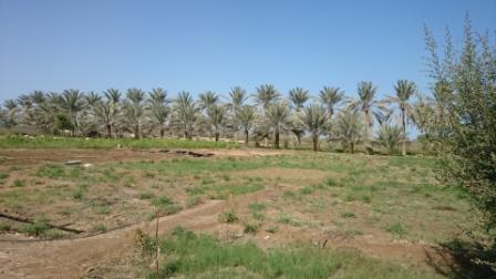
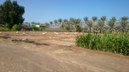
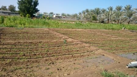
Crops planted are alfalfa, Rhodes grass, corn, Mango, Pomegranate, Date Palm, Henna tree, Buckthorn tree
Purpose of the Technology: Using saline ground water through flood irrigation for leaching salt accumulation and soil sustainability.
Establishment / maintenance activities and inputs: Main inputs are labors, tractor, date palm processing unit and machinery. the maintenance is doing for pipes and machinery.
Natural / human environment: Well water having salinity of 7.13 ds/m is used to irrigate the land also leach the soil. This has resulted an accumulated salt in the soil. Due to increase in soil salinity the cropping pattern has changed drastically. Some years ago the farm was cultivated with a variety of crops but now is limited to growing perennial crops that are salt tolerant. Date palm are the most salt tolerant plants followed by Rhodes and Alfalfa. Mangoes are sensitive to salts compared with other fruit trees.
2.3 Photos of the Technology
Media Gallery
2.5 Country/ region/ locations where the Technology has been applied and which are covered by this assessment
Country:
Oman
Region/ State/ Province:
Al Batinah South
Further specification of location:
Al Massena/ Al Sheeba
Specify the spread of the Technology:
- evenly spread over an area
If the Technology is evenly spread over an area, specify area covered (in km2):
0.0294
If precise area is not known, indicate approximate area covered:
- < 0.1 km2 (10 ha)
Comments:
Total area covered by the SLM Technology is 0.0294 km2.
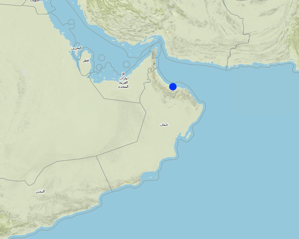
Map
×3. Classification of the SLM Technology
3.1 Main purpose(s) of the Technology
- adapt to climate change/ extremes and its impacts
3.2 Current land use type(s) where the Technology is applied
Land use mixed within the same land unit:
Yes
Specify mixed land use (crops/ grazing/ trees):
- Agro-pastoralism (incl. integrated crop-livestock)

Cropland
- Annual cropping
- Tree and shrub cropping
Specify:
Longest growing period in days: 60; Longest growing period from month to month: october to december; Second longest growing period in days: 45; Second longest growing period from month to month: february to mid of march

Grazing land
Comments:
Major land use problems (compiler’s opinion): soil and water salinity
Future (final) land use (after implementation of SLM Technology): Mixed: Mp: Agro-pastoralism
3.3 Has land use changed due to the implementation of the Technology?
Has land use changed due to the implementation of the Technology?
- Yes (Please fill out the questions below with regard to the land use before implementation of the Technology)
Cropland
- Annual cropping
3.4 Water supply
Water supply for the land on which the Technology is applied:
- full irrigation
3.5 SLM group to which the Technology belongs
- irrigation management (incl. water supply, drainage)
3.6 SLM measures comprising the Technology

agronomic measures
- A2: Organic matter/ soil fertility

vegetative measures
- V1: Tree and shrub cover

management measures
- M2: Change of management/ intensity level
Comments:
Secondary measures: vegetative measures, management measures
Type of agronomic measures: mixed cropping / intercropping, manure / compost / residues, mineral (inorganic) fertilizers
Type of vegetative measures: aligned: -against wind, in blocks
3.7 Main types of land degradation addressed by the Technology

water degradation
- Hq: decline of groundwater quality
Comments:
Main causes of degradation: droughts, population pressure
Secondary causes of degradation: soil management, crop management (annual, perennial, tree/shrub), deforestation / removal of natural vegetation (incl. forest fires), over-exploitation of vegetation for domestic use, urbanisation and infrastructure development
3.8 Prevention, reduction, or restoration of land degradation
Specify the goal of the Technology with regard to land degradation:
- restore/ rehabilitate severely degraded land
Comments:
Secondary goals: prevention of land degradation, mitigation / reduction of land degradation
4. Technical specifications, implementation activities, inputs, and costs
4.1 Technical drawing of the Technology
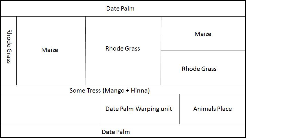
Technical specifications (related to technical drawing):
a farm of 7 feddan mainly grown date palm, rhode grass and ,maize. the farm also a small animal yard.
Technical knowledge required for field staff / advisors: moderate
Technical knowledge required for land users: moderate
Secondary technical functions: control of raindrop splash, control of dispersed runoff: retain / trap, control of dispersed runoff: impede / retard, control of concentrated runoff: retain / trap, control of concentrated runoff: impede / retard, control of concentrated runoff: drain / divert, improvement of ground cover, improvement of surface structure (crusting, sealing), increase in organic matter
Aligned: -against wind
Vegetative material: T : trees / shrubs
In blocks
Vegetative material: G : grass
Slope (which determines the spacing indicated above): 0-2%
Change of land use practices / intensity level: land used for planting Rhodes grass and seasonal crops (recently maize was grown).
4.2 General information regarding the calculation of inputs and costs
other/ national currency (specify):
Omani Rial
If relevant, indicate exchange rate from USD to local currency (e.g. 1 USD = 79.9 Brazilian Real): 1 USD =:
0.39
Indicate average wage cost of hired labour per day:
10.40
4.3 Establishment activities
| Activity | Timing (season) | |
|---|---|---|
| 1. | all day around |
4.4 Costs and inputs needed for establishment
| Specify input | Unit | Quantity | Costs per Unit | Total costs per input | % of costs borne by land users | |
|---|---|---|---|---|---|---|
| Labour | Labour | ha | 1.0 | 120.0 | 120.0 | |
| Total costs for establishment of the Technology | 120.0 | |||||
| Total costs for establishment of the Technology in USD | 307.69 | |||||
4.6 Costs and inputs needed for maintenance/ recurrent activities (per year)
| Specify input | Unit | Quantity | Costs per Unit | Total costs per input | % of costs borne by land users | |
|---|---|---|---|---|---|---|
| Labour | Labour | ha | 1.0 | 120.0 | 120.0 | |
| Total costs for maintenance of the Technology | 120.0 | |||||
| Total costs for maintenance of the Technology in USD | 307.69 | |||||
4.7 Most important factors affecting the costs
Describe the most determinate factors affecting the costs:
labour, seeds, fertilizer and electricty
5. Natural and human environment
5.1 Climate
Annual rainfall
- < 250 mm
- 251-500 mm
- 501-750 mm
- 751-1,000 mm
- 1,001-1,500 mm
- 1,501-2,000 mm
- 2,001-3,000 mm
- 3,001-4,000 mm
- > 4,000 mm
Agro-climatic zone
- arid
Thermal climate class: subtropics
5.2 Topography
Slopes on average:
- flat (0-2%)
- gentle (3-5%)
- moderate (6-10%)
- rolling (11-15%)
- hilly (16-30%)
- steep (31-60%)
- very steep (>60%)
Landforms:
- plateau/plains
- ridges
- mountain slopes
- hill slopes
- footslopes
- valley floors
Altitudinal zone:
- 0-100 m a.s.l.
- 101-500 m a.s.l.
- 501-1,000 m a.s.l.
- 1,001-1,500 m a.s.l.
- 1,501-2,000 m a.s.l.
- 2,001-2,500 m a.s.l.
- 2,501-3,000 m a.s.l.
- 3,001-4,000 m a.s.l.
- > 4,000 m a.s.l.
5.3 Soils
Soil depth on average:
- very shallow (0-20 cm)
- shallow (21-50 cm)
- moderately deep (51-80 cm)
- deep (81-120 cm)
- very deep (> 120 cm)
Soil texture (topsoil):
- medium (loamy, silty)
Topsoil organic matter:
- low (<1%)
If available, attach full soil description or specify the available information, e.g. soil type, soil PH/ acidity, Cation Exchange Capacity, nitrogen, salinity etc.
Soil fertility is very low
Soil drainage / infiltration is good
Soil water storage capacity is medium
5.4 Water availability and quality
Ground water table:
> 50 m
Water quality (untreated):
unusable
5.5 Biodiversity
Species diversity:
- medium
5.6 Characteristics of land users applying the Technology
Market orientation of production system:
- mixed (subsistence/ commercial)
Off-farm income:
- > 50% of all income
Relative level of wealth:
- average
Individuals or groups:
- individual/ household
Gender:
- men
Indicate other relevant characteristics of the land users:
Population density: 50-100 persons/km2
Annual population growth: 1% - 2%
5.7 Average area of land used by land users applying the Technology
- < 0.5 ha
- 0.5-1 ha
- 1-2 ha
- 2-5 ha
- 5-15 ha
- 15-50 ha
- 50-100 ha
- 100-500 ha
- 500-1,000 ha
- 1,000-10,000 ha
- > 10,000 ha
Is this considered small-, medium- or large-scale (referring to local context)?
- small-scale
5.8 Land ownership, land use rights, and water use rights
Land ownership:
- individual, not titled
5.9 Access to services and infrastructure
health:
- poor
- moderate
- good
education:
- poor
- moderate
- good
6. Impacts and concluding statements
6.1 On-site impacts the Technology has shown
Socio-economic impacts
Production
crop production
fodder production
risk of production failure
product diversity
production area
land management
Water availability and quality
irrigation water availability
irrigation water quality
demand for irrigation water
Income and costs
expenses on agricultural inputs
farm income
diversity of income sources
workload
Socio-cultural impacts
food security/ self-sufficiency
health situation
recreational opportunities
community institutions
SLM/ land degradation knowledge
livelihood and human well-being
Comments/ specify:
The technology has improve livelihoods and human well-being of the owner and his family, increasing income of the farmer changed his family lifestyle and a farm become a place for family gathering.
Ecological impacts
Water cycle/ runoff
water quantity
water quality
excess water drainage
groundwater table/ aquifer
evaporation
Soil
soil moisture
soil cover
soil loss
soil crusting/ sealing
nutrient cycling/ recharge
salinity
soil organic matter/ below ground C
Biodiversity: vegetation, animals
biomass/ above ground C
plant diversity
animal diversity
Climate and disaster risk reduction
drought impacts
emission of carbon and greenhouse gases
fire risk
wind velocity
6.3 Exposure and sensitivity of the Technology to gradual climate change and climate-related extremes/ disasters (as perceived by land users)
Gradual climate change
Gradual climate change
| Season | increase or decrease | How does the Technology cope with it? | |
|---|---|---|---|
| annual temperature | increase | not well |
Climate-related extremes (disasters)
Meteorological disasters
| How does the Technology cope with it? | |
|---|---|
| local rainstorm | not known |
| local windstorm | not known |
6.4 Cost-benefit analysis
How do the benefits compare with the establishment costs (from land users’ perspective)?
Short-term returns:
positive
Long-term returns:
positive
How do the benefits compare with the maintenance/ recurrent costs (from land users' perspective)?
Short-term returns:
positive
Long-term returns:
positive
Comments:
due to many different type of crops and grass and trees in the farm, and having date processor increase profit and maintenance is low.
6.5 Adoption of the Technology
- > 50%
If available, quantify (no. of households and/ or area covered):
75 percent of stated area
Of all those who have adopted the Technology, how many did so spontaneously, i.e. without receiving any material incentives/ payments?
- 91-100%
Comments:
There is a moderate trend towards spontaneous adoption of the Technology
Comments on adoption trend: farmers in this area strongly will like to do the same due to high water salinity, in order to wash down salinity, thus, they use flood irrigation technology.
6.7 Strengths/ advantages/ opportunities of the Technology
| Strengths/ advantages/ opportunities in the compiler’s or other key resource person’s view |
|---|
| easily implemented |
| costly effective and every farmer can implement it |
| resist to hard weather condition |
6.8 Weaknesses/ disadvantages/ risks of the Technology and ways of overcoming them
| Weaknesses/ disadvantages/ risks in the compiler’s or other key resource person’s view | How can they be overcome? |
|---|---|
| in long term, ground water will be more deep | reduce over pumping |
| ground water salinity will increase | reduce over pumping |
| salt accumulation in the soil will increase | by using different soil conditioner, gypsum and soil mulch and organic manure |
| soil degradation will be the final result |
7. References and links
7.1 Methods/ sources of information
7.2 References to available publications
Title, author, year, ISBN:
Oman Salinity Strategy, Ministry of Agriculture and Fisheries, 2012
Title, author, year, ISBN:
South Batinah Integrated Study, Ministry of Agriculture and Fisheries, 1993
Title, author, year, ISBN:
Oman General Soil Map, Ministry of Agriculture and Fisheries. 1993
Links and modules
Expand all Collapse allLinks
No links
Modules
No modules