Old Motor Tyre Contours [South Africa]
- Creation:
- Update:
- Compiler: Andrei Rozanov
- Editor: –
- Reviewers: David Streiff, Alexandra Gavilano
technologies_1368 - South Africa
View sections
Expand all Collapse all1. General information
1.2 Contact details of resource persons and institutions involved in the assessment and documentation of the Technology
SLM specialist:
Cujisi K.
UNIN
Van der Walt Isac
Forestry technician:
Voster T.
Department Water Affairs & Forestry, Groblersdal, South Africa
South Africa
Name of the institution(s) which facilitated the documentation/ evaluation of the Technology (if relevant)
University of Stellenbosch (University of Stellenbosch) - South AfricaName of the institution(s) which facilitated the documentation/ evaluation of the Technology (if relevant)
United Nations Institute for Namibia (UNIN) - NamibiaName of the institution(s) which facilitated the documentation/ evaluation of the Technology (if relevant)
Department of Water Affairs and Forestry (DWAF) - South Africa1.3 Conditions regarding the use of data documented through WOCAT
The compiler and key resource person(s) accept the conditions regarding the use of data documented through WOCAT:
Yes
1.5 Reference to Questionnaire(s) on SLM Approaches (documented using WOCAT)

Assistance to community [South Africa]
Community requested assistance to combat soil erosion, only possible when 'Drought Relief Funds' became available.
- Compiler: Philippe Zahner
2. Description of the SLM Technology
2.1 Short description of the Technology
Definition of the Technology:
Old motor tyres and/or vegetation along contours.
2.2 Detailed description of the Technology
Description:
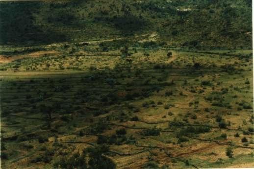
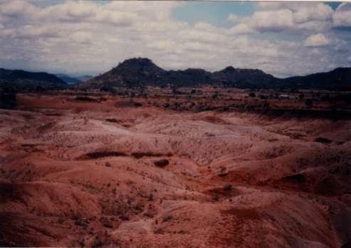
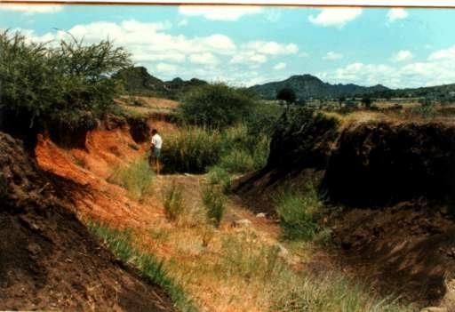
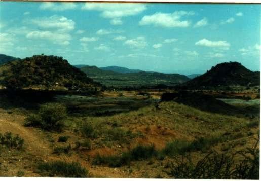
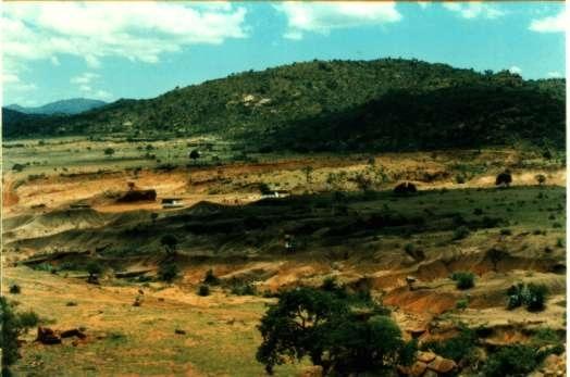
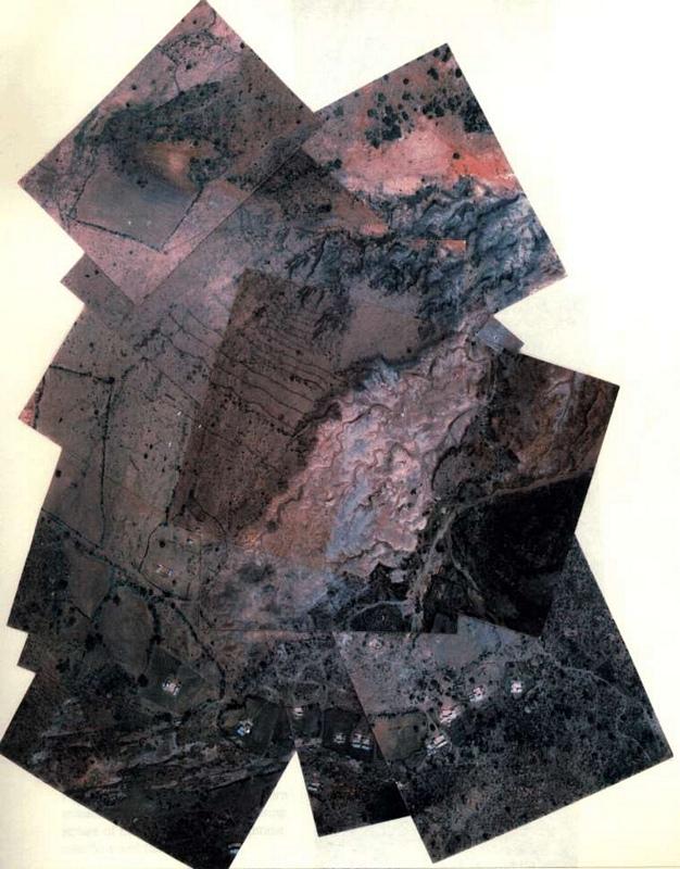
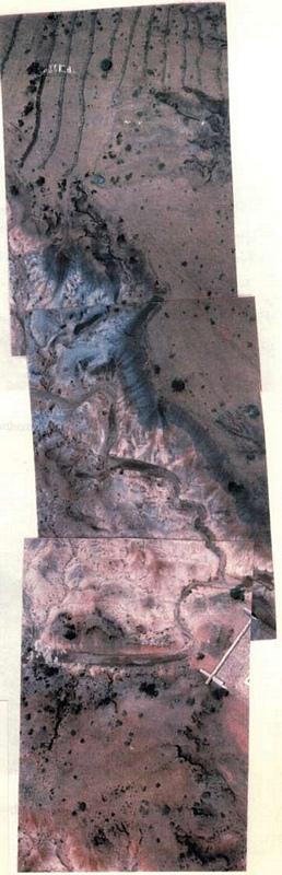
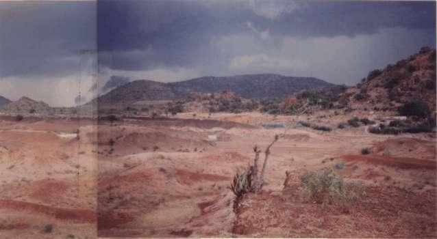
The site of Geen Einde is typical of many areas in Lebowa: a large gully approximately 200 m wide and 10 m deep in places with semi-eroded pedestals remaining. Flood waters from the mountain meanders causes further gouging of the sides of the pedestals. Tributary gullies have formed in the highly erodible soil (high clay content) adjacent to the main gully. Signs of old contour bunds indicate that the land was cultivated in the past.
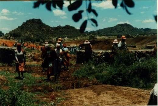
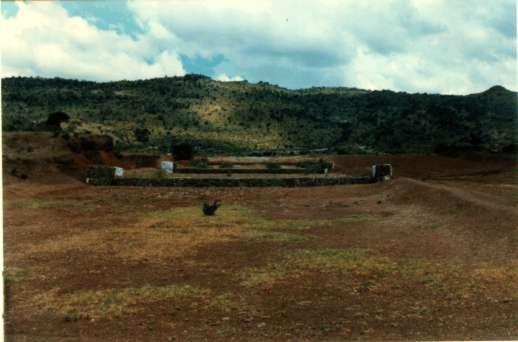
1. An earth silt dam was mechanically constructed across the main erosion gully.
2. Several gabion structures were constructed in the minor gullies.
3. Vetiver grass was planted in the silt to act as nursery material for future planting.
4. Old motor tyres were laid on a level contour above the minor gullies to harvest water.
5. Several species of indigenous trees were planted in the gullies and along the rows of tyres.
6. Two Agave species, local aloes and vetiver grass were planted along level contours.
7. Agave was planted along the edges of the gullies.
8. Shallow gullies were stabilised with old tyres and Agave.
9. Couch grass (Cynodon dactylon) was planted at a few places in the gullies and along the rows of tyres.
The main reason for these actions was to reduce the water velocity.
2.3 Photos of the Technology
Media Gallery
2.5 Country/ region/ locations where the Technology has been applied and which are covered by this assessment
Country:
South Africa
Region/ State/ Province:
Limpopo Province
Further specification of location:
Sekhukhunenland
Specify the spread of the Technology:
- evenly spread over an area
If the Technology is evenly spread over an area, specify area covered (in km2):
0.1
If precise area is not known, indicate approximate area covered:
- 0.1-1 km2
Comments:
Total area covered by the SLM Technology is 0.1 km2.
Green Einde is a tribal area in Sekhukhuneland, which is one of the most severely degraded areas in the Northern Province. It is mainly mountainous, with numerous fertile valleys draining into the Oilfants river, one of the main rivers leading into the Kruger National Park.
Sekhukhuneland is severely degraded. A soil degradation survey done of the former Homeland, Lebowa, by satellite remote sensing in 1993, revealed that in Sekhukhuneland alone approximately 16800ha has become an erosion gully, or bare soil, with little or no vegetation.
This means that 3360 potential farmers have effectively been deprived of 5ha each.
2.6 Date of implementation
If precise year is not known, indicate approximate date:
- less than 10 years ago (recently)
2.7 Introduction of the Technology
Specify how the Technology was introduced:
- during experiments/ research
Comments (type of project, etc.):
Having read about the success achieved by placing stone barriers on a level contour in other parts of Africa, but also being aware that the process is slow and laborious and dependent on the availability of stones, the thought come to mind to use old motor tyres instead.
First in the area (my original idea).
3. Classification of the SLM Technology
3.1 Main purpose(s) of the Technology
- reduce, prevent, restore land degradation
3.2 Current land use type(s) where the Technology is applied

Grazing land
Extensive grazing:
- Semi-nomadic pastoralism

Forest/ woodlands
- (Semi-)natural forests/ woodlands
- Tree plantation, afforestation
(Semi-)natural forests/ woodlands: Specify management type:
- Selective felling
- Clear felling
Products and services:
- Fuelwood
- Other forest products
- Grazing/ browsing
Comments:
Major land use problems (compiler’s opinion): Severe environmental degradation (less graze cover over grazing, considerable silt in the river going into Olifants river a main resource for Kruger National Park, below gabion construction were silted up in one year (some even in one rainstorm).
Major land use problems (land users’ perception): Poverty, land tenure free range for the whole community
Semi-nomadism / pastoralism: Yes
Grazingland comments: The area was not fenced off at all.
Selective felling of (semi-) natural forests: Yes
Clear felling of (semi-)natural forests: one of the reason for erosion
Problems / comments regarding forest use: So far only indigenous trees have been planted, but there are many exotic species that can also be investigated. For example, the carob can be tried as a commercial crop, the mulberry as a fodder and fruit crop.
Forest products and services: fuelwood, grazing / browsing, other forest products / uses (honey, medical, etc.)
Type of grazing system comments: The area was not fenced off at all.
Constraints of settlement / urban: scattered
Number of growing seasons per year: 1
Longest growing period in days: 210
3.5 SLM group to which the Technology belongs
- cross-slope measure
- water harvesting
3.6 SLM measures comprising the Technology

vegetative measures
- V2: Grasses and perennial herbaceous plants

structural measures
- S5: Dams, pans, ponds
Comments:
Main measures: structural measures
Secondary measures: vegetative measures
3.7 Main types of land degradation addressed by the Technology

soil erosion by water
- Wt: loss of topsoil/ surface erosion
- Wg: gully erosion/ gullying
3.8 Prevention, reduction, or restoration of land degradation
Specify the goal of the Technology with regard to land degradation:
- prevent land degradation
- reduce land degradation
Comments:
Secondary goals: mitigation / reduction of land degradation
4. Technical specifications, implementation activities, inputs, and costs
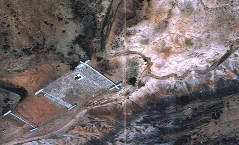
4.1 Technical drawing of the Technology
Technical specifications (related to technical drawing):
Technical knowledge required for field staff / advisors: moderate
Technical knowledge required for land users: low
Main technical functions: improvement of ground cover, increase in organic matter, water harvesting / increase water supply
Secondary technical functions: increase of infiltration, increase / maintain water stored in soil
Vegetative measure: contour
Vegetative material: O : other
Vertical interval within rows / strips / blocks (m): 10cm
Vegetative measure: contour
Vegetative material: O : other
Vertical interval within rows / strips / blocks (m): 1m
Vegetative measure: contour
Vegetative material: O : other
Vertical interval within rows / strips / blocks (m): 20cm
Vegetative measure: contour
Vegetative material: O : other
Trees/ shrubs species: Agave sisalana & Agave mexicane
Grass species: Vetiver
Other species: Acacia tortilis, Portulacaria afra
Slope (which determines the spacing indicated above): 1.00%
If the original slope has changed as a result of the Technology, the slope today is (see figure below): 1.00%
Gradient along the rows / strips: 1.00%
Retention/infiltration ditch/pit, sediment/sand trap
Spacing between structures (m): 10-30
Depth of ditches/pits/dams (m): 30cm
Width of ditches/pits/dams (m): 50cm
Length of ditches/pits/dams (m): 200m
Construction material (other): old motor tyres
Lateral gradient along the structure: 1%
For water harvesting: the ratio between the area where the harvested water is applied and the total area from which water is collected is: 1:30
Vegetation is used for stabilisation of structures.
Control / change of species composition
4.2 General information regarding the calculation of inputs and costs
other/ national currency (specify):
rand
If relevant, indicate exchange rate from USD to local currency (e.g. 1 USD = 79.9 Brazilian Real): 1 USD =:
6.0
Indicate average wage cost of hired labour per day:
4.00
4.3 Establishment activities
| Activity | Timing (season) | |
|---|---|---|
| 1. | transplanting Vetiver and trees | before rains - ongoing |
| 2. | planting Agave | all year round |
| 3. | 1. placing motor tyres and earth | ok-ap (rainseason) |
4.4 Costs and inputs needed for establishment
| Specify input | Unit | Quantity | Costs per Unit | Total costs per input | % of costs borne by land users | |
|---|---|---|---|---|---|---|
| Labour | Labour | ha | 1.0 | 83.35 | 83.35 | |
| Equipment | Machine use | ha | 1.0 | 11.0 | 11.0 | |
| Plant material | Trees | ha | 1.0 | 888.0 | 888.0 | |
| Other | tyre transport | ha | 1.0 | 138.0 | 138.0 | 100.0 |
| Total costs for establishment of the Technology | 1120.35 | |||||
| Total costs for establishment of the Technology in USD | 186.72 | |||||
Comments:
Duration of establishment phase: 36 month(s)
4.5 Maintenance/ recurrent activities
| Activity | Timing/ frequency | |
|---|---|---|
| 1. | pruning / trimming | need /periodically |
4.7 Most important factors affecting the costs
Describe the most determinate factors affecting the costs:
The main expense is transporting the tyres which depends on the distance travelled.
It is obvious that any increase in the cost of labour will have a market impact on final costs.
5. Natural and human environment
5.1 Climate
Annual rainfall
- < 250 mm
- 251-500 mm
- 501-750 mm
- 751-1,000 mm
- 1,001-1,500 mm
- 1,501-2,000 mm
- 2,001-3,000 mm
- 3,001-4,000 mm
- > 4,000 mm
Agro-climatic zone
- semi-arid
thunderstorm
5.2 Topography
Slopes on average:
- flat (0-2%)
- gentle (3-5%)
- moderate (6-10%)
- rolling (11-15%)
- hilly (16-30%)
- steep (31-60%)
- very steep (>60%)
Landforms:
- plateau/plains
- ridges
- mountain slopes
- hill slopes
- footslopes
- valley floors
Altitudinal zone:
- 0-100 m a.s.l.
- 101-500 m a.s.l.
- 501-1,000 m a.s.l.
- 1,001-1,500 m a.s.l.
- 1,501-2,000 m a.s.l.
- 2,001-2,500 m a.s.l.
- 2,501-3,000 m a.s.l.
- 3,001-4,000 m a.s.l.
- > 4,000 m a.s.l.
5.3 Soils
Soil depth on average:
- very shallow (0-20 cm)
- shallow (21-50 cm)
- moderately deep (51-80 cm)
- deep (81-120 cm)
- very deep (> 120 cm)
Soil texture (topsoil):
- fine/ heavy (clay)
Topsoil organic matter:
- low (<1%)
If available, attach full soil description or specify the available information, e.g. soil type, soil PH/ acidity, Cation Exchange Capacity, nitrogen, salinity etc.
Soil depth on average: Also shallow
Soil fertility is low - very low
Soil drainage / infiltration is poor
Soil water storage capacity is low - medium
5.6 Characteristics of land users applying the Technology
Market orientation of production system:
- subsistence (self-supply)
Off-farm income:
- less than 10% of all income
Relative level of wealth:
- very poor
- poor
Indicate other relevant characteristics of the land users:
Population density: 10-50 persons/km2
Annual population growth: 0.5% - 1%
(other income (e.g. bottle store)).
Off-farm income specification: Pension very important
Market orientation of production system: Probable, no sure if on market
5.7 Average area of land used by land users applying the Technology
- < 0.5 ha
- 0.5-1 ha
- 1-2 ha
- 2-5 ha
- 5-15 ha
- 15-50 ha
- 50-100 ha
- 100-500 ha
- 500-1,000 ha
- 1,000-10,000 ha
- > 10,000 ha
5.8 Land ownership, land use rights, and water use rights
Land ownership:
- communal/ village
Land use rights:
- open access (unorganized)
6. Impacts and concluding statements
6.1 On-site impacts the Technology has shown
Socio-economic impacts
Production
fodder production
fodder quality
wood production
production area
Comments/ specify:
stabilised gullies can be used for production, in Lesotho such gullies are allocated
Income and costs
farm income
economic disparities
workload
Other socio-economic impacts
initial cost
Comments/ specify:
relatively cheap method using old tyres and ripper, the main expense is transporting the tyres
Socio-cultural impacts
community institutions
SLM/ land degradation knowledge
conflict mitigation
rehabilitation can take place without denying people/animal
Ecological impacts
Water cycle/ runoff
harvesting/ collection of water
surface runoff
Quantity before SLM:
50
Quantity after SLM:
10
excess water drainage
Soil
soil moisture
soil cover
soil loss
Quantity before SLM:
8
Quantity after SLM:
2
Other ecological impacts
soil fertility
biodiversity
ground level
Comments/ specify:
Not sure if reason is technology
6.2 Off-site impacts the Technology has shown
downstream flooding
6.4 Cost-benefit analysis
How do the benefits compare with the establishment costs (from land users’ perspective)?
Short-term returns:
positive
Long-term returns:
positive
How do the benefits compare with the maintenance/ recurrent costs (from land users' perspective)?
Short-term returns:
neutral/ balanced
Long-term returns:
neutral/ balanced
6.5 Adoption of the Technology
Comments:
There is a moderate trend towards spontaneous adoption of the Technology
Comments on adoption trend: Interest is increasing.
6.7 Strengths/ advantages/ opportunities of the Technology
| Strengths/ advantages/ opportunities in the land user’s view |
|---|
| Easy to implement and benefits from food, fuel and fodder. |
| Improved graze cover. |
| Improved trees cover. |
| Improved trees cover. |
| Strengths/ advantages/ opportunities in the compiler’s or other key resource person’s view |
|---|
|
Capture water and sediment for growth of plants. How can they be sustained / enhanced? More of the same technology. |
|
Improved graze cover. How can they be sustained / enhanced? More of the same technology. |
| Improved trees cover. |
| Improved water management. |
| Improved biodiversity. |
6.8 Weaknesses/ disadvantages/ risks of the Technology and ways of overcoming them
| Weaknesses/ disadvantages/ risks in the land user’s view | How can they be overcome? |
|---|---|
| Paths may be blocked. | Put more soil on the tyres |
| Transport cost for tyres. |
| Weaknesses/ disadvantages/ risks in the compiler’s or other key resource person’s view | How can they be overcome? |
|---|---|
| Transport costs of tyres. | Selesert sponsorship. |
| Tyres all over the area may be unsightly. | Cover the tyres with soil and vegetation. |
7. References and links
7.1 Methods/ sources of information
7.2 References to available publications
Title, author, year, ISBN:
Progress Report. Feb-94.
Available from where? Costs?
C.W. Spies
Links and modules
Expand all Collapse allLinks
Assistance to community [South Africa]
Community requested assistance to combat soil erosion, only possible when 'Drought Relief Funds' became available.
- Compiler: Philippe Zahner
Modules
No modules