Boreda Soil Bund [Ethiopia]
- Creation:
- Update:
- Compiler: Unknown User
- Editor: –
- Reviewers: Fabian Ottiger, Alexandra Gavilano
technologies_1415 - Ethiopia
View sections
Expand all Collapse all1. General information
1.2 Contact details of resource persons and institutions involved in the assessment and documentation of the Technology
Key resource person(s)
SLM specialist:
Mesfin Melaku
Gam Gofa Zone Rural Development Main Department
Ethiopia
Name of the institution(s) which facilitated the documentation/ evaluation of the Technology (if relevant)
Gamo Gofa Zone Rural Development Department - Ethiopia1.3 Conditions regarding the use of data documented through WOCAT
The compiler and key resource person(s) accept the conditions regarding the use of data documented through WOCAT:
Yes
2. Description of the SLM Technology
2.1 Short description of the Technology
Definition of the Technology:
Structure constructed by digging a shallow channel on the upper hill side and putting the excavated soil on the down side to build the embankment
2.2 Detailed description of the Technology
Description:
A structure constructed across the slope along the contour with earth. The embankment is stablized with grasses which is planted during rainy season. Construction is made in groups or by individual farmer, with or without incentives.
Purpose of the Technology: It reduces soil erosion, drain excess runoff during heavy storm which would cause over flow on the land and reduce runoff velocity. Grasses planted on the enbankment for stabilization can solve the animal feed and also soil deposited behind the bund can improve the fertility status of the soil.
Establishment / maintenance activities and inputs: Bunds are continuously repaired during and after heavy storm especially in the first two years after construction. Grasses and tree plant species are planted on the enbankment in order to stablize the structure. Cut and curry and cntroled grazing is common on the embankment.
Natural / human environment: Reduce soil erosion, enhance vegetation growth, improve the beauty of the land scape
2.5 Country/ region/ locations where the Technology has been applied and which are covered by this assessment
Country:
Ethiopia
Region/ State/ Province:
SNNPR
Further specification of location:
Boreda
Specify the spread of the Technology:
- evenly spread over an area
If precise area is not known, indicate approximate area covered:
- 10-100 km2
Comments:
Total area covered by the SLM Technology is 18.29 km2.
scattered SWC activities wrere made in all peasent associations but the above mentioned peasent associations are the dominant once
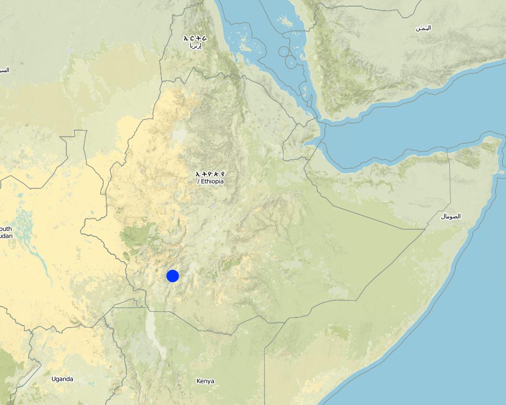
Map
×2.6 Date of implementation
If precise year is not known, indicate approximate date:
- less than 10 years ago (recently)
2.7 Introduction of the Technology
Specify how the Technology was introduced:
- through projects/ external interventions
3. Classification of the SLM Technology
3.2 Current land use type(s) where the Technology is applied

Cropland
- Annual cropping
- Perennial (non-woody) cropping
Annual cropping - Specify crops:
- cereals - barley
- root/tuber crops - sweet potatoes, yams, taro/cocoyam, other
- wheat
- Enset, Desho grass
Number of growing seasons per year:
- 2
Specify:
Longest growing period in days: 180Longest growing period from month to month: Jun - JanSecond longest growing period in days: 120Second longest growing period from month to month: Mar - May
Comments:
Major land use problems (compiler’s opinion): cost of fertilizer, shortage of farm land and grazing land, cultivation of steep slopes
Major land use problems (land users’ perception): cost of fertilizer, shortage of farm land and low productivity
3.4 Water supply
Water supply for the land on which the Technology is applied:
- rainfed
3.5 SLM group to which the Technology belongs
- cross-slope measure
3.6 SLM measures comprising the Technology

vegetative measures

structural measures
- S2: Bunds, banks
Comments:
Secondary measures: vegetative measures
Type of vegetative measures: aligned: -contour
3.7 Main types of land degradation addressed by the Technology

soil erosion by water
- Wt: loss of topsoil/ surface erosion
- Wg: gully erosion/ gullying

chemical soil deterioration
- Cn: fertility decline and reduced organic matter content (not caused by erosion)
Comments:
Main type of degradation addressed: Wt: loss of topsoil / surface erosion
Secondary types of degradation addressed: Wg: gully erosion / gullying, Cn: fertility decline and reduced organic matter content
3.8 Prevention, reduction, or restoration of land degradation
Specify the goal of the Technology with regard to land degradation:
- reduce land degradation
4. Technical specifications, implementation activities, inputs, and costs
4.1 Technical drawing of the Technology
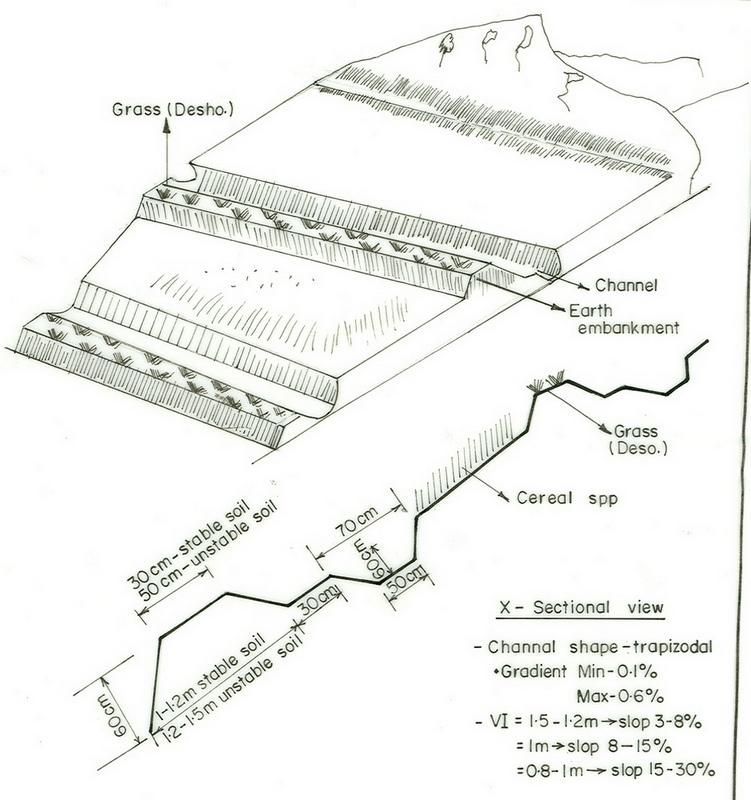
Technical specifications (related to technical drawing):
SNNPR
Technical knowledge required for field staff / advisors: high
Technical knowledge required for land users: high
Main technical functions: reduction of slope angle
Secondary technical functions: control of concentrated runoff: retain / trap, reduction of slope length, increase in soil fertility
Aligned: -contour
Vegetative material: G : grass
Grass species: Desho (it is local grass)
Slope (which determines the spacing indicated above): 19.00%
If the original slope has changed as a result of the Technology, the slope today is (see figure below): 9.00%
Gradient along the rows / strips: 0.00%
Bund/ bank: level
Vertical interval between structures (m): 0.8
Spacing between structures (m): 15
Depth of ditches/pits/dams (m): 0.5
Width of ditches/pits/dams (m): 0.6
Length of ditches/pits/dams (m): 62
Height of bunds/banks/others (m): 0.6
Width of bunds/banks/others (m): 0.5
Length of bunds/banks/others (m): 62
Bund/ bank: graded
Vertical interval between structures (m): 1
Spacing between structures (m): 13
Depth of ditches/pits/dams (m): 0.6
Width of ditches/pits/dams (m): 0.7
Length of ditches/pits/dams (m): 58
Height of bunds/banks/others (m): 0.65
Width of bunds/banks/others (m): 0.5
Length of bunds/banks/others (m): 60
Structural measure: bund/ bank: level
Vertical interval between structures (m): 1
Spacing between structures (m): 13
Depth of ditches/pits/dams (m): 0.6
Width of ditches/pits/dams (m): 0.7
Length of ditches/pits/dams (m): 58
Height of bunds/banks/others (m): 0.65
Width of bunds/banks/others (m): 0.5
Length of bunds/banks/others (m): 60
Construction material (earth): soils excavated from the ditch is used to build the enbankment
Slope (which determines the spacing indicated above): 15%
If the original slope has changed as a result of the Technology, the slope today is: 5%
Lateral gradient along the structure: 0%
For water harvesting: the ratio between the area where the harvested water is applied and the total area from which water is collected is: 1:11
Vegetation is used for stabilisation of structures.
4.2 General information regarding the calculation of inputs and costs
other/ national currency (specify):
Birr
If relevant, indicate exchange rate from USD to local currency (e.g. 1 USD = 79.9 Brazilian Real): 1 USD =:
8.5
Indicate average wage cost of hired labour per day:
0.70
4.3 Establishment activities
| Activity | Timing (season) | |
|---|---|---|
| 1. | raising seedlings and collecting grass | onset of rain season |
| 2. | transplanting | rain season |
| 3. | weeding | at the end of rain season |
| 4. | Surveying | dry season |
| 5. | digging of channel | dry season |
| 6. | build trapezoidal enbankment | dry season |
| 7. | stabilize with grasses | rain season |
4.4 Costs and inputs needed for establishment
| Specify input | Unit | Quantity | Costs per Unit | Total costs per input | % of costs borne by land users | |
|---|---|---|---|---|---|---|
| Labour | Labour | ha | 1.0 | 52.5 | 52.5 | |
| Equipment | Machine use | ha | 1.0 | 15.0 | 15.0 | 100.0 |
| Plant material | Grass | ha | 1.0 | 20.0 | 20.0 | |
| Total costs for establishment of the Technology | 87.5 | |||||
| Total costs for establishment of the Technology in USD | 10.29 | |||||
Comments:
Duration of establishment phase: 12 month(s)
4.5 Maintenance/ recurrent activities
| Activity | Timing/ frequency | |
|---|---|---|
| 1. | replanting | |
| 2. | removal of deposited soils from the ditches | dry season/annual |
4.6 Costs and inputs needed for maintenance/ recurrent activities (per year)
| Specify input | Unit | Quantity | Costs per Unit | Total costs per input | % of costs borne by land users | |
|---|---|---|---|---|---|---|
| Labour | Replanting and removal of deposited soils from the ditches | ha | 1.0 | 4.38 | 4.38 | |
| Total costs for maintenance of the Technology | 4.38 | |||||
| Total costs for maintenance of the Technology in USD | 0.52 | |||||
Comments:
the culculation is based on the length of the structures per hectar of land
4.7 Most important factors affecting the costs
Describe the most determinate factors affecting the costs:
slope
5. Natural and human environment
5.1 Climate
Annual rainfall
- < 250 mm
- 251-500 mm
- 501-750 mm
- 751-1,000 mm
- 1,001-1,500 mm
- 1,501-2,000 mm
- 2,001-3,000 mm
- 3,001-4,000 mm
- > 4,000 mm
Specify average annual rainfall (if known), in mm:
1800.00
Agro-climatic zone
- humid
- sub-humid
5.2 Topography
Slopes on average:
- flat (0-2%)
- gentle (3-5%)
- moderate (6-10%)
- rolling (11-15%)
- hilly (16-30%)
- steep (31-60%)
- very steep (>60%)
Landforms:
- plateau/plains
- ridges
- mountain slopes
- hill slopes
- footslopes
- valley floors
Altitudinal zone:
- 0-100 m a.s.l.
- 101-500 m a.s.l.
- 501-1,000 m a.s.l.
- 1,001-1,500 m a.s.l.
- 1,501-2,000 m a.s.l.
- 2,001-2,500 m a.s.l.
- 2,501-3,000 m a.s.l.
- 3,001-4,000 m a.s.l.
- > 4,000 m a.s.l.
Comments and further specifications on topography:
Landforms: Hill slopes. Also ridges and plateau/plains
Slopes on average: Hilly. Also moderate and rolling
5.3 Soils
Soil depth on average:
- very shallow (0-20 cm)
- shallow (21-50 cm)
- moderately deep (51-80 cm)
- deep (81-120 cm)
- very deep (> 120 cm)
Soil texture (topsoil):
- medium (loamy, silty)
- fine/ heavy (clay)
Topsoil organic matter:
- medium (1-3%)
- low (<1%)
If available, attach full soil description or specify the available information, e.g. soil type, soil PH/ acidity, Cation Exchange Capacity, nitrogen, salinity etc.
Soil fertility is low-medium
Soil drainage/infiltration is medium-poor
Soil water storage capacity is medium-high
5.6 Characteristics of land users applying the Technology
Market orientation of production system:
- subsistence (self-supply)
- mixed (subsistence/ commercial)
Off-farm income:
- less than 10% of all income
Relative level of wealth:
- poor
- average
Level of mechanization:
- manual work
- animal traction
Indicate other relevant characteristics of the land users:
Population density: 50-100 persons/km2
Annual population growth: 1% - 2%
1% of the land users are rich and own 3% of the land.
39% of the land users are average wealthy and own 72% of the land.
60% of the land users are poor and own 25% of the land.
Level of mechanization: Manual labour (hand tools) and animal traction (oxen)
5.7 Average area of land used by land users applying the Technology
- < 0.5 ha
- 0.5-1 ha
- 1-2 ha
- 2-5 ha
- 5-15 ha
- 15-50 ha
- 50-100 ha
- 100-500 ha
- 500-1,000 ha
- 1,000-10,000 ha
- > 10,000 ha
6. Impacts and concluding statements
6.1 On-site impacts the Technology has shown
Socio-economic impacts
Production
crop production
fodder production
fodder quality
production area
land management
Income and costs
workload
Socio-cultural impacts
SLM/ land degradation knowledge
Ecological impacts
Water cycle/ runoff
surface runoff
Quantity before SLM:
69
Quantity after SLM:
45
excess water drainage
Soil
soil loss
Quantity before SLM:
4.9
Quantity after SLM:
4
Other ecological impacts
Soil fertility
Waterlogging
6.2 Off-site impacts the Technology has shown
downstream flooding
downstream siltation
6.4 Cost-benefit analysis
How do the benefits compare with the establishment costs (from land users’ perspective)?
Short-term returns:
positive
Long-term returns:
very positive
How do the benefits compare with the maintenance/ recurrent costs (from land users' perspective)?
Short-term returns:
neutral/ balanced
Long-term returns:
slightly positive
6.5 Adoption of the Technology
Comments:
62% of land user families have adopted the Technology with external material support
1367 land user families have adopted the Technology with external material support
Comments on acceptance with external material support: estimates
30% of land user families have adopted the Technology without any external material support
721 land user families have adopted the Technology without any external material support
Comments on spontaneous adoption: estimates
There is a little trend towards spontaneous adoption of the Technology
Comments on adoption trend: the posetive results of the conserved land attracts some the farmes to applythe technique by themselves without and external support
6.7 Strengths/ advantages/ opportunities of the Technology
| Strengths/ advantages/ opportunities in the land user’s view |
|---|
|
erosion and runoff control How can they be sustained / enhanced? maintenance every cropping season |
| Strengths/ advantages/ opportunities in the compiler’s or other key resource person’s view |
|---|
|
Reduce soil erosion and concentrated runoff How can they be sustained / enhanced? frequent maintaince |
|
Water harvesting and increase infiltration of the soil How can they be sustained / enhanced? Improve access to marketing of valuable crops |
|
Grasses and fodder plant species have solved the problem for animal feed How can they be sustained / enhanced? plant improved fodder species |
6.8 Weaknesses/ disadvantages/ risks of the Technology and ways of overcoming them
| Weaknesses/ disadvantages/ risks in the land user’s view | How can they be overcome? |
|---|---|
| more labour required | form development commettee with working groups |
| Weaknesses/ disadvantages/ risks in the compiler’s or other key resource person’s view | How can they be overcome? |
|---|---|
| occupied cultivated lands | increase the productivity of land per unit area |
Links and modules
Expand all Collapse allLinks
No links
Modules
No modules