Boreda Soil Bund [ប្រទេសអេត្យូពី]
- ការបង្កើត៖
- បច្ចុប្បន្នភាព
- អ្នកចងក្រង៖ Unknown User
- អ្នកកែសម្រួល៖ –
- អ្នកត្រួតពិនិត្យច្រើនទៀត៖ Fabian Ottiger, Alexandra Gavilano
technologies_1415 - ប្រទេសអេត្យូពី
ពិនិត្យមើលគ្រប់ផ្នែក
ពង្រីកមើលទាំងអស់ បង្រួមទាំងអស់1. ព័ត៌មានទូទៅ
1.2 ព័ត៌មានលម្អិតពីបុគ្គលសំខាន់ៗ និងស្ថាប័នដែលចូលរួមក្នុងការវាយតម្លៃ និងចងក្រងឯកសារនៃបច្ចេកទេស
បុគ្គលសំខាន់ម្នាក់ (ច្រើននាក់)
អ្នកជំនាញឯកទេស SLM:
Mesfin Melaku
Gam Gofa Zone Rural Development Main Department
ប្រទេសអេត្យូពី
ឈ្មោះអង្គភាពមួយ (ច្រើន) ដែលបានចងក្រងឯកសារ/ វាយតម្លៃបច្ចេកទេស (បើទាក់ទង)
Gamo Gofa Zone Rural Development Department - ប្រទេសអេត្យូពី1.3 លក្ខខណ្ឌទាក់ទងទៅនឹងការប្រើប្រាស់ទិន្នន័យដែលបានចងក្រងតាមរយៈ វ៉ូខេត
អ្នកចងក្រង និង(បុគ្គលសំខាន់ៗ)យល់ព្រមទទួលយកនូវលក្ខខណ្ឌនានាទាក់ទងទៅនឹងការប្រើប្រាស់ទិន្នន័យដែលបានចងក្រងតាមរយៈវ៉ូខេត:
បាទ/ចា៎
2. ការពណ៌នាពីបច្ចេកទេស SLM
2.1 ការពណ៌នាដោយសង្ខេបពីបច្ចេកទេស
និយមន័យបច្ចេកទេស:
Structure constructed by digging a shallow channel on the upper hill side and putting the excavated soil on the down side to build the embankment
2.2 ការពណ៌នាលម្អិតពីបច្ចេកទេស
ការពណ៌នា:
A structure constructed across the slope along the contour with earth. The embankment is stablized with grasses which is planted during rainy season. Construction is made in groups or by individual farmer, with or without incentives.
Purpose of the Technology: It reduces soil erosion, drain excess runoff during heavy storm which would cause over flow on the land and reduce runoff velocity. Grasses planted on the enbankment for stabilization can solve the animal feed and also soil deposited behind the bund can improve the fertility status of the soil.
Establishment / maintenance activities and inputs: Bunds are continuously repaired during and after heavy storm especially in the first two years after construction. Grasses and tree plant species are planted on the enbankment in order to stablize the structure. Cut and curry and cntroled grazing is common on the embankment.
Natural / human environment: Reduce soil erosion, enhance vegetation growth, improve the beauty of the land scape
2.5 ប្រទេស/តំបន់/ទីតាំងកន្លែង ដែលបច្ចេកទេសត្រូវបានអនុវត្ត និងបានគ្រប់ដណ្តប់ដោយការវាយតម្លៃនេះ
ប្រទេស:
ប្រទេសអេត្យូពី
តំបន់/រដ្ឋ/ខេត្ត:
SNNPR
បញ្ជាក់បន្ថែមពីលក្ខណៈនៃទីតាំង:
Boreda
បញ្ជាក់ពីការសាយភាយនៃបច្ចេកទេស:
- ត្រូវបានផ្សព្វផ្សាយត្រឹមតំបន់មួយ
ប្រសិនបើមិនច្បាស់ពីទំហំផ្ទៃដី សូមធ្វើការប៉ាន់ប្រម៉ាណ:
- 10-100 គម2
មតិយោបល់:
Total area covered by the SLM Technology is 18.29 km2.
scattered SWC activities wrere made in all peasent associations but the above mentioned peasent associations are the dominant once
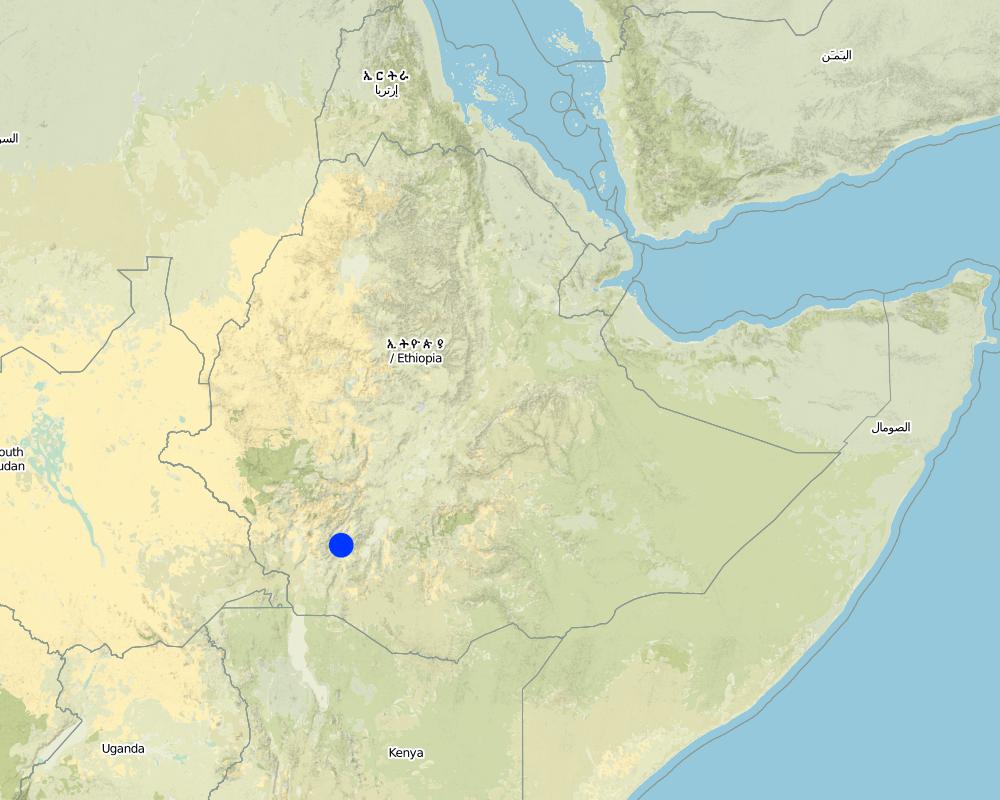
Map
×2.6 កាលបរិច្ឆេទនៃការអនុវត្ត
ប្រសិនបើមិនច្បាស់ឆ្នាំ សូមបញ្ជាក់កាលបរិច្ឆេទដែលប្រហាក់ប្រហែល:
- តិចជាង 10ឆ្នាំមុន (ថ្មី)
2.7 ការណែនាំពីបច្ចេកទេស
សូមបញ្ជាក់តើបច្ចេកទេសត្រូវបានណែនាំឱ្យអនុវត្តដោយរបៀបណា:
- តាមរយៈគម្រោង / អន្តរាគមន៍ពីខាងក្រៅ
3. ចំណាត់ថ្នាក់នៃបច្ចេកទេស SLM
3.2 ប្រភេទដីប្រើប្រាស់មួយប្រភេទ (ច្រើនប្រភេទ) ដែលបានអនុវត្តបច្ចេកទេស

ដីដាំដំណាំ
- ដំណាំប្រចាំឆ្នាំ
- ដំណាំរយៈពេលវែង (មិនមែនឈើ)
ដំណាំប្រចាំឆ្នាំ - បញ្ជាក់ប្រភេទដំណាំ:
- ធញ្ញជាតិ - ស្រូវ
- ឬស/ដំណាំមើម - ដំឡូងជ្វា ពពួកដំឡូង ត្រាវ ផ្សេងៗ
- wheat
- Enset, Desho grass
ចំនួនសារដែលដាំដំណាំក្នុងមួយឆ្នាំ:
- 2
សូមបញ្ជាក់:
Longest growing period in days: 180Longest growing period from month to month: Jun - JanSecond longest growing period in days: 120Second longest growing period from month to month: Mar - May
មតិយោបល់:
Major land use problems (compiler’s opinion): cost of fertilizer, shortage of farm land and grazing land, cultivation of steep slopes
Major land use problems (land users’ perception): cost of fertilizer, shortage of farm land and low productivity
3.4 ការផ្គត់ផ្គង់ទឹក
ការផ្គត់ផ្គង់ទឹកនៅកន្លែងអនុវត្តបច្ចេកទេស:
- ទឹកភ្លៀង
3.5 ក្រុម SLM ដែលបច្ចេកទេសស្ថិតនៅក្នុង
- វិធានការអនុវត្តកាត់ទទឹងទីជម្រាល
3.6 វិធានការ SLM ដែលបញ្ចូលនូវបច្ចេកទេស

វិធានការរុក្ខជាតិ

វិធានការរចនាស័ម្ពន្ធ
- S2: ភ្លឺ ច្រាំង
មតិយោបល់:
Secondary measures: vegetative measures
Type of vegetative measures: aligned: -contour
3.7 កំណត់ប្រភេទនៃការធ្លាក់ចុះគុណភាពដីសំខាន់ៗដែលបច្ចេកទេសនេះបានដោះស្រាយ

ការហូរច្រោះដីដោយសារទឹក
- Wt: ការបាត់ដីស្រទាប់លើដោយការហូរច្រោះ
- Wg: ការកកើតឡើងនូវកំទេចកំទីដីស្រទាប់ក្រោម

ការធ្លាក់ចុះសារធាតុគីមីក្នុងដី
- Cn: ការថយចុះជីជាតិ និងកាត់បន្ថយបរិមាណសារធាតុសរីរាង្គ (មិនកើតឡើងដោយការហូរច្រោះទេ)
មតិយោបល់:
Main type of degradation addressed: Wt: loss of topsoil / surface erosion
Secondary types of degradation addressed: Wg: gully erosion / gullying, Cn: fertility decline and reduced organic matter content
3.8 ការពារ កាត់បន្ថយ ឬស្តារឡើងវិញនៃការធ្លាក់ចុះគុណភាពដី
បញ្ជាក់ពីគោលដៅរបស់បច្ចេកទេស ដែលផ្តោតទៅការធ្លាក់ចុះគុណភាពដី:
- ការកាត់បន្ថយការធ្លាក់ចុះគុណភាពដី
4. បច្ចេកទេសជាក់លាក់ សកម្មភាពអនុវត្ត ធាតុចូល និងថ្លៃដើម
4.1 គំនូសបច្ចេកទេសនៃបច្ចេកទេសនេះ
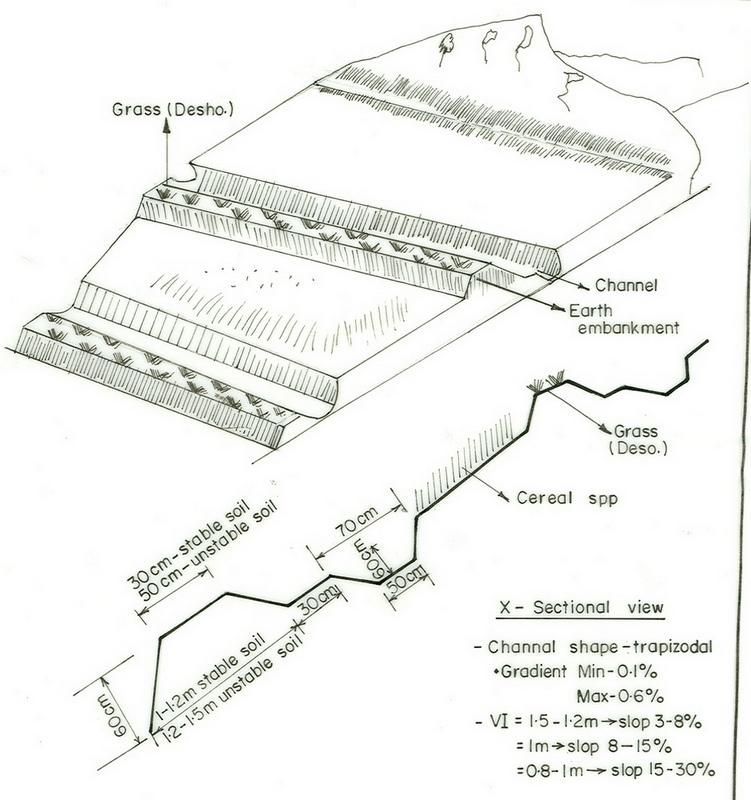
លក្ខណៈពិសេសនៃបច្ចេកទេស (ទាក់ទងនឺងគំនូរបច្ចេកទេស):
SNNPR
Technical knowledge required for field staff / advisors: high
Technical knowledge required for land users: high
Main technical functions: reduction of slope angle
Secondary technical functions: control of concentrated runoff: retain / trap, reduction of slope length, increase in soil fertility
Aligned: -contour
Vegetative material: G : grass
Grass species: Desho (it is local grass)
Slope (which determines the spacing indicated above): 19.00%
If the original slope has changed as a result of the Technology, the slope today is (see figure below): 9.00%
Gradient along the rows / strips: 0.00%
Bund/ bank: level
Vertical interval between structures (m): 0.8
Spacing between structures (m): 15
Depth of ditches/pits/dams (m): 0.5
Width of ditches/pits/dams (m): 0.6
Length of ditches/pits/dams (m): 62
Height of bunds/banks/others (m): 0.6
Width of bunds/banks/others (m): 0.5
Length of bunds/banks/others (m): 62
Bund/ bank: graded
Vertical interval between structures (m): 1
Spacing between structures (m): 13
Depth of ditches/pits/dams (m): 0.6
Width of ditches/pits/dams (m): 0.7
Length of ditches/pits/dams (m): 58
Height of bunds/banks/others (m): 0.65
Width of bunds/banks/others (m): 0.5
Length of bunds/banks/others (m): 60
Structural measure: bund/ bank: level
Vertical interval between structures (m): 1
Spacing between structures (m): 13
Depth of ditches/pits/dams (m): 0.6
Width of ditches/pits/dams (m): 0.7
Length of ditches/pits/dams (m): 58
Height of bunds/banks/others (m): 0.65
Width of bunds/banks/others (m): 0.5
Length of bunds/banks/others (m): 60
Construction material (earth): soils excavated from the ditch is used to build the enbankment
Slope (which determines the spacing indicated above): 15%
If the original slope has changed as a result of the Technology, the slope today is: 5%
Lateral gradient along the structure: 0%
For water harvesting: the ratio between the area where the harvested water is applied and the total area from which water is collected is: 1:11
Vegetation is used for stabilisation of structures.
4.2 ព័ត៌មានទូទៅដែលពាក់ព័ន្ធនឹងការគណនាធាតុចូល និងថ្លៃដើម
ផ្សេងៗ/ រូបិយប័ណ្ណជាតិ (បញ្ជាក់):
Birr
បើពាក់ព័ន្ធសូមកំណត់អត្រាប្តូរប្រាក់ពីដុល្លាទៅរូបិយប័ណ្ណតំបន់ (ឧ. 1 ដុល្លារ = 79.9 រៀលនៃរូបិយប័ណ្ណប្រេស៊ីល) ៖ 1 ដុល្លារ =:
8,5
កំណត់ថ្លៃឈ្នួលជាមធ្យមនៃការជួលកម្លាំងពលកម្មក្នុងមួយថ្ងៃ:
0.70
4.3 សកម្មភាពបង្កើត
| សកម្មភាព | រយៈពេល (រដូវកាល) | |
|---|---|---|
| 1. | raising seedlings and collecting grass | onset of rain season |
| 2. | transplanting | rain season |
| 3. | weeding | at the end of rain season |
| 4. | Surveying | dry season |
| 5. | digging of channel | dry season |
| 6. | build trapezoidal enbankment | dry season |
| 7. | stabilize with grasses | rain season |
4.4 ថ្លៃដើម និងធាតុចូលដែលត្រូវការសម្រាប់ការបង្កើតបច្ចេកទេស
| បញ្ជាក់ពីធាតុចូល | ឯកតា | បរិមាណ | ថ្លៃដើមក្នុងមួយឯកតា | ថ្លៃធាតុចូលសរុប | % នៃថ្លៃដើមដែលចំណាយដោយអ្នកប្រើប្រាស់ដី | |
|---|---|---|---|---|---|---|
| កម្លាំងពលកម្ម | Labour | ha | 1,0 | 52,5 | 52,5 | |
| សម្ភារៈ | Machine use | ha | 1,0 | 15,0 | 15,0 | 100,0 |
| សម្ភារៈដាំដុះ | Grass | ha | 1,0 | 20,0 | 20,0 | |
| ថ្លៃដើមសរុបក្នុងការបង្កើតបច្ចេកទេស | 87,5 | |||||
| ថ្លៃដើមសរុបក្នុងការបង្កើតបច្ចេកទេសគិតជាដុល្លារ | 10,29 | |||||
មតិយោបល់:
Duration of establishment phase: 12 month(s)
4.5 សកម្មភាពថែទាំ
| សកម្មភាព | ពេលវេលា/ ភាពញឹកញាប់ | |
|---|---|---|
| 1. | replanting | |
| 2. | removal of deposited soils from the ditches | dry season/annual |
4.6 កំណត់ថ្លៃដើមសម្រាប់ការថែទាំ/ សកម្មភាពរបស់បច្ចេកទេស (ក្នុងរយៈពេលមួយឆ្នាំ)
| បញ្ជាក់ពីធាតុចូល | ឯកតា | បរិមាណ | ថ្លៃដើមក្នុងមួយឯកតា | ថ្លៃធាតុចូលសរុប | % នៃថ្លៃដើមដែលចំណាយដោយអ្នកប្រើប្រាស់ដី | |
|---|---|---|---|---|---|---|
| កម្លាំងពលកម្ម | Replanting and removal of deposited soils from the ditches | ha | 1,0 | 4,38 | 4,38 | |
| ថ្លៃដើមសរុបសម្រាប់ការថែទាំដំណាំតាមបច្ចេកទេស | 4,38 | |||||
| ថ្លៃដើមសរុបសម្រាប់ការថែទាំដំណាំតាមបច្ចេកទេសគិតជាដុល្លារ | 0,52 | |||||
មតិយោបល់:
the culculation is based on the length of the structures per hectar of land
4.7 កត្តាសំខាន់បំផុតដែលមានឥទ្ធិពលដល់ការចំណាយ
ពណ៌នាពីកត្តាប៉ះពាល់ចម្បងៗទៅលើថ្លៃដើម:
slope
5. លក្ខណៈបរិស្ថានធម្មជាតិ និងមនុស្ស
5.1 អាកាសធាតុ
បរិមាណទឹកភ្លៀងប្រចាំឆ្នាំ
- < 250 មម
- 251-500 មម
- 501-750 មម
- 751-1,000 មម
- 1,001-1,500 មម
- 1,501-2,000 មម
- 2,001-3,000 មម
- 3,001-4,000 មម
- > 4,000 មម
កំណត់បរិមាណទឹកភ្លៀង (បើដឹង) ជា មីលីម៉ែត្រ:
1800,00
តំបន់កសិអាកាសធាតុ
- សើម
- មានភ្លៀងមធ្យម
5.2 សណ្ឋានដី
ជម្រាលជាមធ្យម:
- រាបស្មើ (0-2%)
- ជម្រាលតិចតួច (3-5%)
- មធ្យម (6-10%)
- ជម្រាលខ្ពស់បន្តិច (11-15%)
- ទីទួល (16-30%)
- ទីទួលចោត (31-60%)
- ទីទួលចោតខ្លាំង (>60%)
ទម្រង់ដី:
- ខ្ពង់រាប
- កំពូលភ្នំ
- ជម្រាលភ្នំ
- ជម្រាលទួល
- ជម្រាលជើងភ្នំ
- បាតជ្រលងភ្នំ
តំបន់តាមរយៈកម្ពស់ :
- 0-100 ម
- 101-500 ម
- 501-1,000 ម
- 1,001-1,500 ម
- 1,501-2,000 ម
- 2,001-2,500 ម
- 2,501-3,000 ម
- 3,001-4,000 ម
- > 4,000 ម
មតិយោបល់ និងបញ្ចាក់បន្ថែមអំពីសណ្ឋានដី :
Landforms: Hill slopes. Also ridges and plateau/plains
Slopes on average: Hilly. Also moderate and rolling
5.3 ដី
ជម្រៅដីជាមធ្យម:
- រាក់ខ្លាំង (0-20 សម)
- រាក់ (21-50 សម)
- មធ្យម (51-80 សម)
- ជ្រៅ (81-120 សម)
- ជ្រៅខ្លាំង (> 120 សម)
វាយនភាពដី (ស្រទាប់លើ):
- មធ្យម (ល្បាយ, ល្បាប់)
- ម៉ត់/ ធ្ងន់ (ឥដ្ឋ)
សារធាតុសរីរាង្គនៅស្រទាប់ដីខាងលើ:
- មធ្យម (1-3%)
- ទាប (<1%)
បើអាចសូមភ្ជាប់ការពណ៌នាពីដីឱ្យបានច្បាស់ ឬព័ត៌មានដែលអាចទទួលបាន ឧ. ប្រភេទដី, pH ដី/ ជាតិអាស៊ីត, សមត្ថភាពផ្លាស់ប្តូរកាចុង, វត្តមាននីត្រូសែន, ភាពប្រៃ ។ល។:
Soil fertility is low-medium
Soil drainage/infiltration is medium-poor
Soil water storage capacity is medium-high
5.6 លក្ខណៈនៃអ្នកប្រើប្រាស់ដីដែលអនុវត្តបច្ចេកទេស
ទីផ្សារនៃប្រព័ន្ធផលិតកម្ម:
- សម្រាប់ហូបក្នុងគ្រួសារ (ផ្គត់ផ្គង់ខ្លួនឯង)
- ពាក់កណ្តាលពាណិជ្ជកម្ម (ផ្គត់ផ្គង់ខ្លួនឯង/ ពាណិជ្ជកម្ម)
ចំណូលក្រៅកសិកម្ម:
- តិចជាង 10% នៃចំណូល
កម្រិតជីវភាព:
- មិនល្អ
- មធ្យម
កម្រិតប្រើប្រាស់គ្រឿងយន្ត:
- ប្រើកម្លាំងពលកម្ម
- ប្រើកម្លាំងសត្វ
សូមបញ្ជាក់ពីលក្ខណៈពាក់ព័ន្ធផ្សេងទៀតអំពីអ្នកប្រើប្រាស់ដី:
Population density: 50-100 persons/km2
Annual population growth: 1% - 2%
1% of the land users are rich and own 3% of the land.
39% of the land users are average wealthy and own 72% of the land.
60% of the land users are poor and own 25% of the land.
Level of mechanization: Manual labour (hand tools) and animal traction (oxen)
5.7 ទំហំផ្ទៃដីជាមធ្យមនៃដីប្រើប្រាស់ដោយអ្នកប្រើប្រាស់ដី ក្នុងការអនុវត្តបច្ចេកទេស
- < 0.5 ហិកតា
- 0.5-1 ហិកតា
- 1-2 ហិកតា
- 2-5 ហិកតា
- 5-15 ហិកតា
- 15-50 ហិកតា
- 50-100 ហិកតា
- 100-500 ហិកតា
- 500-1,000 ហិកតា
- 1,000-10,000 ហិកតា
- > 10,000 ហិកតា
6. ផលប៉ះពាល់ និងការសន្និដ្ឋាន
6.1 ផលប៉ះពាល់ក្នុងបរិវេណអនុវត្តបច្ចេកទេសដែលកើតមាន
ផលប៉ះពាល់លើសេដ្ឋកិច្ចសង្គម
ផលិតផល
ផលិតកម្មដំណាំ
ផលិតកម្មចំណីសត្វ
គុណភាពចំណីសត្វ
ផ្ទៃដីផលិតកម្ម
ការគ្រប់គ្រងដី
ចំណូល និងថ្លៃដើម
បន្ទុកការងារ
ផលប៉ះពាល់ទៅលើវប្បធម៌សង្គម
ចំណេះដឹង SLM / ការធ្លាក់ចុះគុណភាពដី
ផលប៉ះពាល់ទៅលើអេកូឡូស៊ី
វដ្តទឹក/លំហូរ
លំហូរទឹកលើផ្ទៃដី
គុណភាពមុន SLM:
69
គុណភាពក្រោយ SLM:
45
ប្រព័ន្ធបង្ហូរទឹក
ដី
ការបាត់បង់ដី
គុណភាពមុន SLM:
4.9
គុណភាពក្រោយ SLM:
4
ផលប៉ះពាល់ទៅលើអេកូឡូស៊ីផ្សេងៗ
Soil fertility
Waterlogging
6.2 ផលប៉ះពាល់ក្រៅបរិវេណអនុវត្តបច្ចេកទេសដែលកើតមាន
ទឹកជំនន់ខ្សែទឹកខាងក្រោម
កំណកល្បាប់ខ្សែទឹកខាងក្រោម
6.4 ការវិភាគថ្លៃដើម និងអត្ថប្រយោជន៍
តើផលចំណេញ និងថ្លៃដើមត្រូវបានប្រៀបធៀបគ្នាយ៉ាងដូចម្តេច (ទស្សនៈរបស់អ្នកប្រើប្រាស់ដី)?
រយៈពេលខ្លី:
វិជ្ជមាន
រយៈពេលវែង:
វិជ្ជមានខ្លាំង
តើផលចំណេញ និងការថែទាំ/ ជួសជុលត្រូវបានប្រៀបធៀបគ្នាយ៉ាងដូចម្តេច (ទស្សនៈរបស់អ្នកប្រើប្រាស់ដី)?
រយៈពេលខ្លី:
ប៉ះពាល់តិចតួចបំផុត
រយៈពេលវែង:
វិជ្ជមានតិចតួច
6.5 ការទទួលយកបច្ចេកទេស
មតិយោបល់:
62% of land user families have adopted the Technology with external material support
1367 land user families have adopted the Technology with external material support
Comments on acceptance with external material support: estimates
30% of land user families have adopted the Technology without any external material support
721 land user families have adopted the Technology without any external material support
Comments on spontaneous adoption: estimates
There is a little trend towards spontaneous adoption of the Technology
Comments on adoption trend: the posetive results of the conserved land attracts some the farmes to applythe technique by themselves without and external support
6.7 ភាពខ្លាំង/ គុណសម្បត្តិ/ ឱកាសនៃបច្ចេកទេស
| ភាពខ្លាំង/ គុណសម្បត្តិ/ ឱកាសនៅកន្លែងរបស់អ្នកប្រើប្រាស់ដី |
|---|
|
erosion and runoff control How can they be sustained / enhanced? maintenance every cropping season |
| ភាពខ្លាំង/ គុណសម្បត្តិ/ ឱកាស ទស្សនៈរបស់បុគ្គលសំខាន់ៗ |
|---|
|
Reduce soil erosion and concentrated runoff How can they be sustained / enhanced? frequent maintaince |
|
Water harvesting and increase infiltration of the soil How can they be sustained / enhanced? Improve access to marketing of valuable crops |
|
Grasses and fodder plant species have solved the problem for animal feed How can they be sustained / enhanced? plant improved fodder species |
6.8 ភាពខ្សោយ/ គុណវិបត្តិ/ ហានិភ័យនៃបច្ចេកទេស និងវិធីសាស្ត្រដោះស្រាយ
| ភាពខ្សោយ/ គុណវិបត្តិ/ ហានិភ័យ ទស្សនៈរបស់អ្នកប្រើប្រាស់ដី | តើបច្ចេកទេសទាំងនោះបានដោះស្រាយបញ្ហាដូចម្តេច? |
|---|---|
| more labour required | form development commettee with working groups |
| ភាពខ្សោយ/ គុណវិបត្តិ/ ហានិភ័យ ទស្សនៈរបស់អ្នកចងក្រងឬបុគ្គលសំខាន់ៗ | តើបច្ចេកទេសទាំងនោះបានដោះស្រាយបញ្ហាដូចម្តេច? |
|---|---|
| occupied cultivated lands | increase the productivity of land per unit area |
ការតភ្ជាប់ និងម៉ូឌុល
ពង្រីកមើលទាំងអស់ បង្រួមទាំងអស់ការតភ្ជាប់
គ្មានការតភ្ជាប់
ម៉ូឌុល
គ្មានម៉ូឌុល