Diversion Weir [India]
- Creation:
- Update:
- Compiler: Niranjan Sahu
- Editor: –
- Reviewers: Fabian Ottiger, Alexandra Gavilano
Cement muda
technologies_1481 - India
View sections
Expand all Collapse all1. General information
1.2 Contact details of resource persons and institutions involved in the assessment and documentation of the Technology
SLM specialist:
Mohanty Rajib Kumar
India
SLM specialist:
Khatua Santosh
India
1.3 Conditions regarding the use of data documented through WOCAT
The compiler and key resource person(s) accept the conditions regarding the use of data documented through WOCAT:
Yes
1.5 Reference to Questionnaire(s) on SLM Approaches (documented using WOCAT)
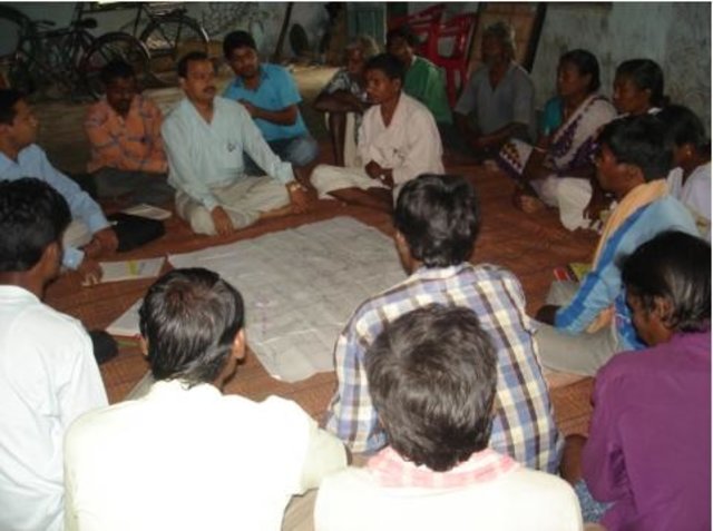
Common Interest Group Approach in Watershed Development [India]
Group is formed based on a common interest such as irrigation to their fileds from the diversion weir.
- Compiler: Philippe Zahner
2. Description of the SLM Technology
2.1 Short description of the Technology
Definition of the Technology:
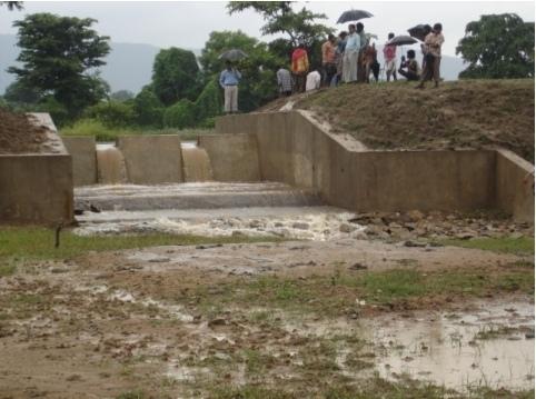
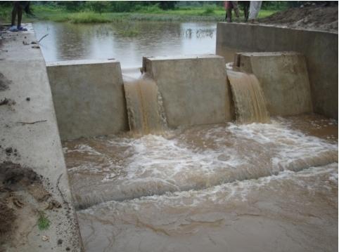
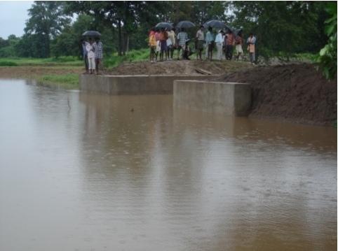
Diversion weir is a masonary check dam constructed across a perinnial or semi perinnial stream to divert the runoff water into land users field for irrigation.
2.2 Detailed description of the Technology
Description:
Reduce the velocity and volume of runoff in the down stream. Use the runoff water for irrigation purpose. Sand casting and flash flood is reduced. More land is brought under cultivation due to increased water availability.
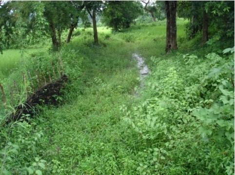
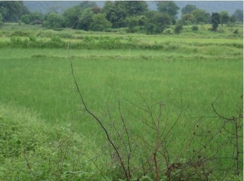
2.3 Photos of the Technology
Media Gallery
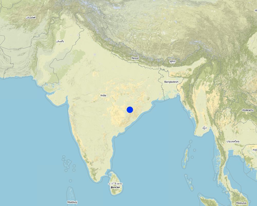
2.5 Country/ region/ locations where the Technology has been applied and which are covered by this assessment
Country:
India
Region/ State/ Province:
Orissa
Further specification of location:
Koksara, Kalahandi
Comments:
Total area covered by the SLM Technology is 50 km2.
Diversion weir is a masonary check dam constructed across a nala/drainage line which is perenneial or semiperenneial. After a temporary storage in the upstream, water is diverted to land user filed as irrigation water.
Map
×2.6 Date of implementation
If precise year is not known, indicate approximate date:
- less than 10 years ago (recently)
2.7 Introduction of the Technology
Specify how the Technology was introduced:
- through projects/ external interventions
Comments (type of project, etc.):
Soil Conservation Department
3. Classification of the SLM Technology
3.1 Main purpose(s) of the Technology
- improve production
- adapt to climate change/ extremes and its impacts
3.2 Current land use type(s) where the Technology is applied
Land use mixed within the same land unit:
Yes
Specify mixed land use (crops/ grazing/ trees):
- Agroforestry

Cropland
- Annual cropping
Annual cropping - Specify crops:
- cereals - rice (wetland)
- oilseed crops - groundnuts
- vegetables - other
- vegetables - root vegetables (carrots, onions, beet, other)
Number of growing seasons per year:
- 2
Specify:
Longest growing period in days: 140Longest growing period from month to month: Jun - SepSecond longest growing period in days: 90Second longest growing period from month to month: Oct - Feb
Comments:
Major land use problems (compiler’s opinion): Small land holding, Volme and duration of availability of water. Sand casting, Flash flooding, wash out of field bunds.
Major land use problems (land users’ perception): Sand casting and flash flood destroy our crops frequently when the rainfall is high where as crop loss and drought occur due to low rainfall.
Type of cropping system and major crops comments: Paddy-Onion; Paddy-vegetables
3.4 Water supply
Water supply for the land on which the Technology is applied:
- rainfed
3.5 SLM group to which the Technology belongs
- irrigation management (incl. water supply, drainage)
- water diversion and drainage
- surface water management (spring, river, lakes, sea)
3.6 SLM measures comprising the Technology

structural measures
- S5: Dams, pans, ponds
Comments:
Main measures: structural measures
Secondary measures: vegetative measures
3.7 Main types of land degradation addressed by the Technology

soil erosion by water
- Wg: gully erosion/ gullying
- Wr: riverbank erosion
- Wo: offsite degradation effects
Comments:
Main type of degradation addressed: Wg: gully erosion / gullying
Secondary types of degradation addressed: Wr: riverbank erosion, Wo: offsite degradation effects
Main causes of degradation: other natural causes (avalanches, volcanic eruptions, mud flows, highly susceptible natural resources, extreme topography, etc.) specify, poverty / wealth (lack of captial)
Secondary causes of degradation: deforestation / removal of natural vegetation (incl. forest fires), other human induced causes (specify) (agricultural causes), land tenure (land subdivision), education, access to knowledge and support services (lack of knowledge)
3.8 Prevention, reduction, or restoration of land degradation
Specify the goal of the Technology with regard to land degradation:
- prevent land degradation
- restore/ rehabilitate severely degraded land
Comments:
Main goals: prevention of land degradation
Secondary goals: rehabilitation / reclamation of denuded land
4. Technical specifications, implementation activities, inputs, and costs
4.1 Technical drawing of the Technology
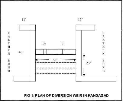
Technical specifications (related to technical drawing):
Plan of diversion weir in Kandagad
Location: Kandagad. Orissa
Technical knowledge required for field staff / advisors: moderate
Technical knowledge required for land users: low
Main technical functions: control of concentrated runoff: impede / retard
Secondary technical functions: reduction of slope length, water harvesting / increase water supply
Dam/ pan/ pond
Vertical interval between structures (m): 15 feet
Spacing between structures (m): 1500 feet
Depth of ditches/pits/dams (m): 10 feet
Width of ditches/pits/dams (m): 35
Length of ditches/pits/dams (m): 45
Height of bunds/banks/others (m): 12
Width of bunds/banks/others (m): 40
Length of bunds/banks/others (m): 50
Slope (which determines the spacing indicated above): 1%
If the original slope has changed as a result of the Technology, the slope today is: 0%
For water harvesting: the ratio between the area where the harvested water is applied and the total area from which water is collected is: 1:10
Vegetation is used for stabilisation of structures.
Change of land use type: Crop plan as per water availability
4.2 General information regarding the calculation of inputs and costs
other/ national currency (specify):
INR
If relevant, indicate exchange rate from USD to local currency (e.g. 1 USD = 79.9 Brazilian Real): 1 USD =:
40.0
Indicate average wage cost of hired labour per day:
2.00
4.3 Establishment activities
| Activity | Timing (season) | |
|---|---|---|
| 1. | Layout of the structure | May |
| 2. | Digging of foundation | May |
| 3. | Construction of foundation and superstructure | June |
4.4 Costs and inputs needed for establishment
| Specify input | Unit | Quantity | Costs per Unit | Total costs per input | % of costs borne by land users | |
|---|---|---|---|---|---|---|
| Labour | Labour | ha | 1.0 | 2700.0 | 2700.0 | |
| Construction material | Stone | ha | 1.0 | 900.0 | 900.0 | |
| Total costs for establishment of the Technology | 3600.0 | |||||
| Total costs for establishment of the Technology in USD | 90.0 | |||||
Comments:
Duration of establishment phase: 24060 month(s)
4.5 Maintenance/ recurrent activities
| Activity | Timing/ frequency | |
|---|---|---|
| 1. | Operation of the scoure sluice | rainy season/ |
4.6 Costs and inputs needed for maintenance/ recurrent activities (per year)
Comments:
Length of the structure
4.7 Most important factors affecting the costs
Describe the most determinate factors affecting the costs:
Cost of cement, stone and transportation
5. Natural and human environment
5.1 Climate
Annual rainfall
- < 250 mm
- 251-500 mm
- 501-750 mm
- 751-1,000 mm
- 1,001-1,500 mm
- 1,501-2,000 mm
- 2,001-3,000 mm
- 3,001-4,000 mm
- > 4,000 mm
Agro-climatic zone
- semi-arid
5.2 Topography
Slopes on average:
- flat (0-2%)
- gentle (3-5%)
- moderate (6-10%)
- rolling (11-15%)
- hilly (16-30%)
- steep (31-60%)
- very steep (>60%)
Landforms:
- plateau/plains
- ridges
- mountain slopes
- hill slopes
- footslopes
- valley floors
Altitudinal zone:
- 0-100 m a.s.l.
- 101-500 m a.s.l.
- 501-1,000 m a.s.l.
- 1,001-1,500 m a.s.l.
- 1,501-2,000 m a.s.l.
- 2,001-2,500 m a.s.l.
- 2,501-3,000 m a.s.l.
- 3,001-4,000 m a.s.l.
- > 4,000 m a.s.l.
Comments and further specifications on topography:
Landforms: Also Hill slopes and valley floors (both ranked 2)
5.3 Soils
Soil depth on average:
- very shallow (0-20 cm)
- shallow (21-50 cm)
- moderately deep (51-80 cm)
- deep (81-120 cm)
- very deep (> 120 cm)
Soil texture (topsoil):
- coarse/ light (sandy)
Topsoil organic matter:
- high (>3%)
- medium (1-3%)
If available, attach full soil description or specify the available information, e.g. soil type, soil PH/ acidity, Cation Exchange Capacity, nitrogen, salinity etc.
Soil fertility : Medium
Soil drainage/infiltration: Good
Soil water storage capacity: Low (ranked 1) and medium (ranked 2)
5.6 Characteristics of land users applying the Technology
Market orientation of production system:
- mixed (subsistence/ commercial)
Off-farm income:
- less than 10% of all income
Relative level of wealth:
- poor
- average
Level of mechanization:
- animal traction
- mechanized/ motorized
Indicate other relevant characteristics of the land users:
Population density: 50-100 persons/km2
Annual population growth: 1% - 2%
23% of the land users are average wealthy.
47% of the land users are poor.
18% of the land users are poor.
Off-farm income specification: Off farm employment opportunities are created due to better cropping system and production
Level of mechanization: Manual work (ranked 1, bullock drawn implements) and mechanised (ranked 2, tractor for ploughing the field and transportation)
Market orientation: Mixed (Paddy as staple food and onion as a commercial crop)
5.7 Average area of land used by land users applying the Technology
- < 0.5 ha
- 0.5-1 ha
- 1-2 ha
- 2-5 ha
- 5-15 ha
- 15-50 ha
- 50-100 ha
- 100-500 ha
- 500-1,000 ha
- 1,000-10,000 ha
- > 10,000 ha
Comments:
Average area of land owned or leased by land users applying the Technology: Also 2-5 ha
5.8 Land ownership, land use rights, and water use rights
Land ownership:
- communal/ village
- individual, titled
6. Impacts and concluding statements
6.1 On-site impacts the Technology has shown
Socio-economic impacts
Production
crop production
production area
Income and costs
farm income
Socio-cultural impacts
community institutions
SLM/ land degradation knowledge
Ecological impacts
Soil
soil moisture
soil loss
Other ecological impacts
Soil fertility
Sand casting
Flash floods
Washout of bunds
6.2 Off-site impacts the Technology has shown
reliable and stable stream flows in dry season
downstream siltation
6.4 Cost-benefit analysis
How do the benefits compare with the establishment costs (from land users’ perspective)?
Short-term returns:
positive
Long-term returns:
positive
How do the benefits compare with the maintenance/ recurrent costs (from land users' perspective)?
Short-term returns:
positive
Long-term returns:
positive
6.5 Adoption of the Technology
Comments:
100% of land user families have adopted the Technology with external material support
45 land user families have adopted the Technology with external material support
Comments on acceptance with external material support: survey results
There is a little trend towards spontaneous adoption of the Technology
Comments on adoption trend: Due to heavy initial investments
6.7 Strengths/ advantages/ opportunities of the Technology
| Strengths/ advantages/ opportunities in the land user’s view |
|---|
| Earlier the runoff was passing through a single nala, now the irrigation channels have been opened at three points which are commanding more are |
| Sand casting is stopped now |
| water table in the wells have increased |
| Strengths/ advantages/ opportunities in the compiler’s or other key resource person’s view |
|---|
|
Crop loss is minimised due to long dry spell How can they be sustained / enhanced? The command area needs to be developed with surplus and field channels |
| Productivity of the land has increased |
6.8 Weaknesses/ disadvantages/ risks of the Technology and ways of overcoming them
| Weaknesses/ disadvantages/ risks in the compiler’s or other key resource person’s view | How can they be overcome? |
|---|---|
| A corpus needs to be developed for future maintenance of the structure |
7. References and links
7.1 Methods/ sources of information
Links and modules
Expand all Collapse allLinks
Common Interest Group Approach in Watershed Development [India]
Group is formed based on a common interest such as irrigation to their fileds from the diversion weir.
- Compiler: Philippe Zahner
Modules
No modules