Degraded communal pasture Obishur [Tajikistan]
- Creation:
- Update:
- Compiler: Malgorzata Conder
- Editor: –
- Reviewers: Fabian Ottiger, Alexandra Gavilano
technologies_1545 - Tajikistan
View sections
Expand all Collapse all1. General information
1.2 Contact details of resource persons and institutions involved in the assessment and documentation of the Technology
Name of the institution(s) which facilitated the documentation/ evaluation of the Technology (if relevant)
NCCR North-South (NCCR North-South) - KyrgyzstanName of the institution(s) which facilitated the documentation/ evaluation of the Technology (if relevant)
CDE Centre for Development and Environment (CDE Centre for Development and Environment) - Switzerland1.3 Conditions regarding the use of data documented through WOCAT
The compiler and key resource person(s) accept the conditions regarding the use of data documented through WOCAT:
Yes
2. Description of the SLM Technology
2.1 Short description of the Technology
Definition of the Technology:
Degraded communal pasture without grazing management and sufficient waterpoints
2.2 Detailed description of the Technology
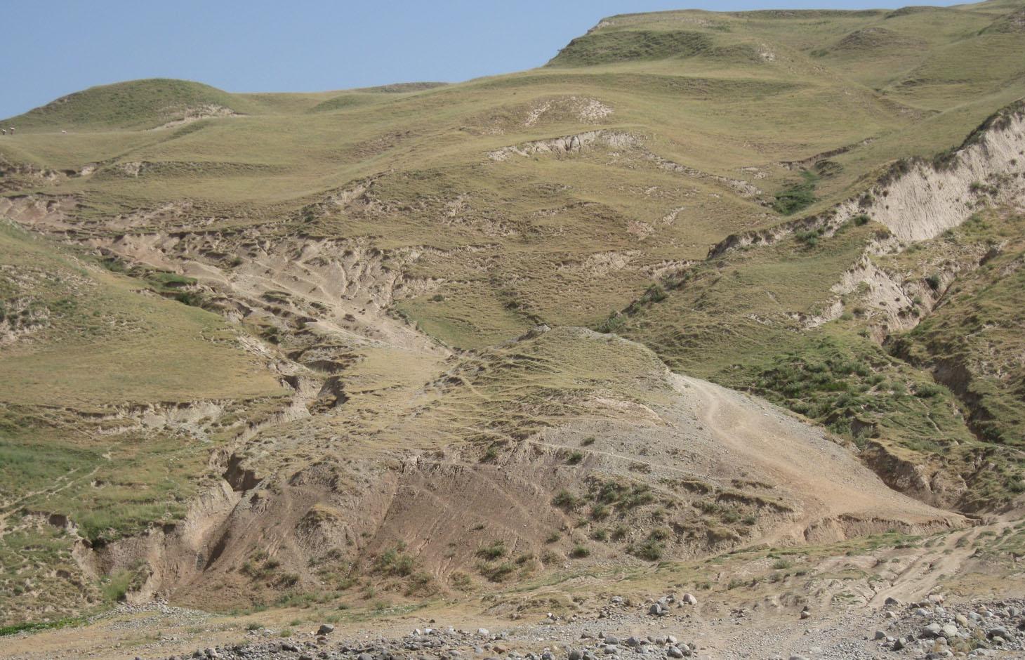
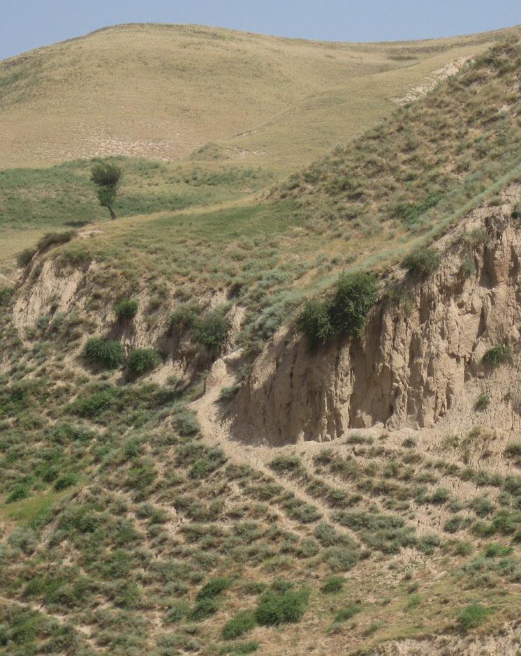
Description:
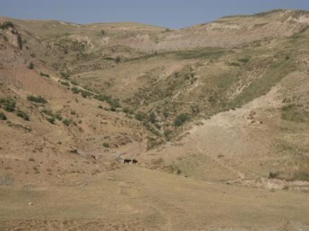
On the communal pasture, located at the foothill around 85 households graze their livestock totally 500 cows and 100 sheep and goats. Half of the households of the village Momandion have livestock which is meant to graze at different places on that pasture. As there is no water point higher up in the pasture area, livestock grazes near the village where a water point is installed. The rolling zone is totally overgrazed and shows several deep gullies. Cows and the small livestock are divided for grazing. Every family is looking after a herd for a day every month. Although the families of the herding livestock communicate with each other, there is no planning for a sustainable grazing management.
Purpose of the Technology: The whole plot is overgrazed and livestock is increasing, so at least controlled pasture management could be expected to decrease the degradation process. Additionally, more vegetation would be available for feeding livestock. More water points have to be installed higher up in the pasture, to decrease pressure on soil and vegetation. More waterpoints would extend the area to be used for grazing. Another issue is that nobody really feels responsible for the pasture and its management. This explains why no pasture management exists at Jamoat level. Farmers are not organized in terms of pasture rotation and control. Livestock owners pay very small rent, which does not make them vakue the pastureland. Additionally, the tax is not enough for projects or investments (like installing water points).
Establishment / maintenance activities and inputs: Every household pays 12 Somoni per year for pasture rent, which is in total around 1000 Somoni. Rent is per household not per livestock number. No maintenance is done.
Natural / human environment: The pasture extends from the foothill to the upper parts of the hill with a high percentage of overgrazed, trampled, erosive area. Except for the water point near the village, there is no water and no shady points for livestock. 85 households graze their livestock, which total 1500 cows and small livestock. Every household is responsible for grazing the herd one day every month. Apart from that, no management exists between the families and Jamoat.
2.3 Photos of the Technology
Media Gallery
2.5 Country/ region/ locations where the Technology has been applied and which are covered by this assessment
Country:
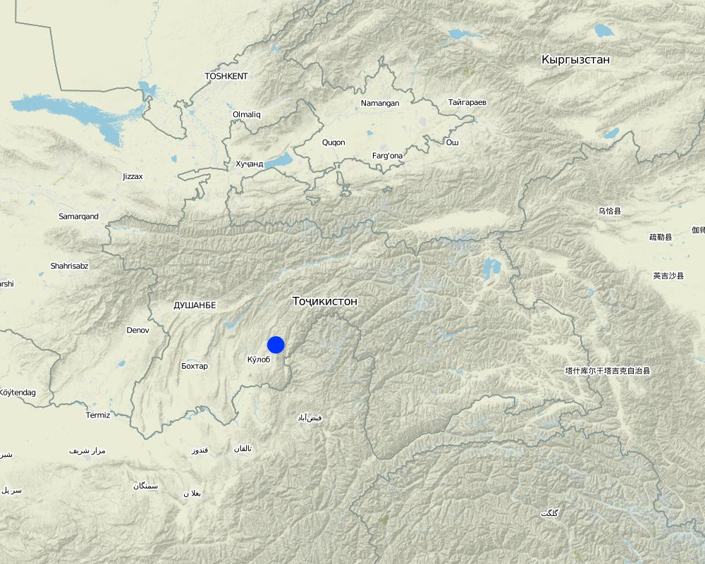
Tajikistan
Region/ State/ Province:
Khatlon, Tajikistan
Further specification of location:
Muminabad
Specify the spread of the Technology:
- evenly spread over an area
If precise area is not known, indicate approximate area covered:
- 0.1-1 km2
Comments:
Total area covered by the SLM Technology is 0.94 km2.
Farmer (Vakil) did not know at all the area extent, data based on Google Earth
Map
×3. Classification of the SLM Technology
3.1 Main purpose(s) of the Technology
- reduce, prevent, restore land degradation
3.2 Current land use type(s) where the Technology is applied

Grazing land
Extensive grazing:
- Semi-nomadic pastoralism
Animal type:
- goats
- sheep
- cows
Comments:
Livestock density (if relevant):
50-100 LU /km2
Major land use problems (compiler’s opinion): Overgrazing, soil compaction, soil and gully erosion, increasing vegetation cover and hence lower resilience for disaster risks
Major land use problems (land users’ perception): More livestock reduces vegetation cover through overgrazing and trampling. Gully formation. Not enough water acces in the pastureland.
Semi-nomadism / pastoralism: cow, sheep, goat
Grazingland comments: Evtl. summer pasture
semi-nomadism within an delimited communal area, intensive pastoralism due to overgrazing
Type of grazing system comments: Evtl. summer pasture
semi-nomadism within an delimited communal area, intensive pastoralism due to overgrazing
3.4 Water supply
Water supply for the land on which the Technology is applied:
- rainfed
3.5 SLM group to which the Technology belongs
- pastoralism and grazing land management
- Water points
3.6 SLM measures comprising the Technology

management measures
- M2: Change of management/ intensity level
- M3: Layout according to natural and human environment
3.7 Main types of land degradation addressed by the Technology

soil erosion by water
- Wt: loss of topsoil/ surface erosion
- Wg: gully erosion/ gullying

soil erosion by wind
- Eo: offsite degradation effects

physical soil deterioration
- Pc: compaction

biological degradation
- Bc: reduction of vegetation cover

water degradation
- Hs: change in quantity of surface water
Comments:
Main type of degradation addressed: Wt: loss of topsoil / surface erosion, Eo: offsite degradation effects, Bc: reduction of vegetation cover, Hs: change in quantity of surface water
Secondary types of degradation addressed: Wg: gully erosion / gullying, Pc: compaction
Main causes of degradation: overgrazing (No controlled grazing), population pressure (Increasing livestock), land tenure (Communal property=No individual responsibility)
Secondary causes of degradation: deforestation / removal of natural vegetation (incl. forest fires) (one or two decades ago), disturbance of water cycle (infiltration / runoff), poverty / wealth
3.8 Prevention, reduction, or restoration of land degradation
Specify the goal of the Technology with regard to land degradation:
- reduce land degradation
- restore/ rehabilitate severely degraded land
Comments:
Main goals: rehabilitation / reclamation of denuded land
Secondary goals: mitigation / reduction of land degradation
4. Technical specifications, implementation activities, inputs, and costs
4.1 Technical drawing of the Technology
Technical specifications (related to technical drawing):
Bare vegetation cover, no trees, soil erosion, trampled paths, rill building, no waterpoints are all calling for pasture management among the villages.
Location: Obishur watershed, Momandion. Muminabad, Khatlon, Tajikistan
Technical knowledge required for field staff / advisors: moderate
Technical knowledge required for land users: low
Main technical functions: control of concentrated runoff: impede / retard, improvement of ground cover, stabilisation of soil (eg by tree roots against land slides), increase of infiltration
Secondary technical functions: control of dispersed runoff: impede / retard, increase of surface roughness, improvement of surface structure (crusting, sealing), improvement of topsoil structure (compaction), increase in organic matter, increase in nutrient availability (supply, recycling,…), increase / maintain water stored in soil, increase of biomass (quantity), spatial arrangement and diversification of land use
Change of land use practices / intensity level: Controlled access, staged grazing
Author:
Malgorzata Conder
4.2 General information regarding the calculation of inputs and costs
other/ national currency (specify):
Somoni
If relevant, indicate exchange rate from USD to local currency (e.g. 1 USD = 79.9 Brazilian Real): 1 USD =:
4.83
Indicate average wage cost of hired labour per day:
12.40
4.3 Establishment activities
| Activity | Timing (season) | |
|---|---|---|
| 1. | Possible solutions: Pasture ManagementWorkshops, Meetings, Round table | |
| 2. | Water points | |
| 3. | Reduce Livestock quantity |
4.7 Most important factors affecting the costs
Describe the most determinate factors affecting the costs:
It wouldn not be expensive to hold regular meetings between the livestock keeping families for a better organization of the grazing area. The installation of a water point is very costly and labour intensive in contrast.
5. Natural and human environment
5.1 Climate
Annual rainfall
- < 250 mm
- 251-500 mm
- 501-750 mm
- 751-1,000 mm
- 1,001-1,500 mm
- 1,501-2,000 mm
- 2,001-3,000 mm
- 3,001-4,000 mm
- > 4,000 mm
Specifications/ comments on rainfall:
Totally 800 mm: 700mm in winter-spring, July-Sept dry season
Agro-climatic zone
- sub-humid
Thermal climate class: temperate, LPG from end of March until September
5.2 Topography
Slopes on average:
- flat (0-2%)
- gentle (3-5%)
- moderate (6-10%)
- rolling (11-15%)
- hilly (16-30%)
- steep (31-60%)
- very steep (>60%)
Landforms:
- plateau/plains
- ridges
- mountain slopes
- hill slopes
- footslopes
- valley floors
Altitudinal zone:
- 0-100 m a.s.l.
- 101-500 m a.s.l.
- 501-1,000 m a.s.l.
- 1,001-1,500 m a.s.l.
- 1,501-2,000 m a.s.l.
- 2,001-2,500 m a.s.l.
- 2,501-3,000 m a.s.l.
- 3,001-4,000 m a.s.l.
- > 4,000 m a.s.l.
Comments and further specifications on topography:
Slopes on average: Steep (ranked 1, approx. 40%) and hilly (ranked 2)
5.3 Soils
Soil depth on average:
- very shallow (0-20 cm)
- shallow (21-50 cm)
- moderately deep (51-80 cm)
- deep (81-120 cm)
- very deep (> 120 cm)
Soil texture (topsoil):
- coarse/ light (sandy)
If available, attach full soil description or specify the available information, e.g. soil type, soil PH/ acidity, Cation Exchange Capacity, nitrogen, salinity etc.
Soil fertility: Low
Soil drainage/infiltration: Poor
Soil water storage capacity: Very low
5.4 Water availability and quality
Ground water table:
> 50 m
Availability of surface water:
poor/ none
Water quality (untreated):
unusable
5.5 Biodiversity
Species diversity:
- low
5.6 Characteristics of land users applying the Technology
Market orientation of production system:
- subsistence (self-supply)
Off-farm income:
- less than 10% of all income
Relative level of wealth:
- average
Individuals or groups:
- groups/ community
Gender:
- men
Indicate other relevant characteristics of the land users:
Land users applying the Technology are mainly common / average land users
Population density: 100-200 persons/km2
Annual population growth: 1% - 2%
5.7 Average area of land used by land users applying the Technology
- < 0.5 ha
- 0.5-1 ha
- 1-2 ha
- 2-5 ha
- 5-15 ha
- 15-50 ha
- 50-100 ha
- 100-500 ha
- 500-1,000 ha
- 1,000-10,000 ha
- > 10,000 ha
Is this considered small-, medium- or large-scale (referring to local context)?
- small-scale
Comments:
2.4 ha, if 7.7 pers/household counted. In total 3040 ha pasture
5.8 Land ownership, land use rights, and water use rights
Land ownership:
- communal/ village
Land use rights:
- individual
Water use rights:
- leased
Comments:
Land ownership is based on Land user certificates
5.9 Access to services and infrastructure
health:
- poor
- moderate
- good
education:
- poor
- moderate
- good
technical assistance:
- poor
- moderate
- good
employment (e.g. off-farm):
- poor
- moderate
- good
markets:
- poor
- moderate
- good
energy:
- poor
- moderate
- good
roads and transport:
- poor
- moderate
- good
drinking water and sanitation:
- poor
- moderate
- good
financial services:
- poor
- moderate
- good
6. Impacts and concluding statements
6.1 On-site impacts the Technology has shown
Socio-economic impacts
Production
animal production
Comments/ specify:
Less forage available for livestock due to reduce vegetation cover
wood production
Comments/ specify:
important clear-cutting in the past
land management
Quantity before SLM:
no organizational task without pasture management
Comments/ specify:
no organizational task without pasture management
Water availability and quality
water availability for livestock
Comments/ specify:
lack of water points for livestock
water quality for livestock
Comments/ specify:
lack of water points for livestock
Income and costs
expenses on agricultural inputs
Comments/ specify:
more fodder has to be bought, because grazing is insufficient
farm income
Comments/ specify:
Less forage for livestock
workload
Comments/ specify:
no organizational task without pasture management / feeding animals
Socio-cultural impacts
food security/ self-sufficiency
Comments/ specify:
More difficult to feed livestock
Improved livelihoods and human well-being
Ecological impacts
Water cycle/ runoff
surface runoff
groundwater table/ aquifer
Soil
soil moisture
soil cover
soil crusting/ sealing
soil compaction
soil organic matter/ below ground C
Climate and disaster risk reduction
wind velocity
6.2 Off-site impacts the Technology has shown
downstream flooding
buffering/ filtering capacity
damage on public/ private infrastructure
6.3 Exposure and sensitivity of the Technology to gradual climate change and climate-related extremes/ disasters (as perceived by land users)
Gradual climate change
Gradual climate change
| Season | increase or decrease | How does the Technology cope with it? | |
|---|---|---|---|
| annual temperature | increase | well |
Climate-related extremes (disasters)
Meteorological disasters
| How does the Technology cope with it? | |
|---|---|
| local rainstorm | not well |
Climatological disasters
| How does the Technology cope with it? | |
|---|---|
| drought | not well |
Hydrological disasters
| How does the Technology cope with it? | |
|---|---|
| general (river) flood | not well |
Comments:
Pasture rotation would improve vegetation cover, infiltration, slope stabilization and natural disaster resilience
Rotate within the grazing land and less energy needed by livestock, which leads also to less consumption and hence overgrazing
6.7 Strengths/ advantages/ opportunities of the Technology
| Strengths/ advantages/ opportunities in the compiler’s or other key resource person’s view |
|---|
|
Establishment of rotational grazing is not expensive and does not require further equipment How can they be sustained / enhanced? Empower communication and decision-making also between the farmers |
6.8 Weaknesses/ disadvantages/ risks of the Technology and ways of overcoming them
| Weaknesses/ disadvantages/ risks in the compiler’s or other key resource person’s view | How can they be overcome? |
|---|---|
| Importance of rotational grazing depends on Jamoat and farmers level | Strengthen communication between Jamoat and farmers through consultancy, meetings etc. Farmer as tenants should get a voice. |
| Pastureland rent is too cheap and is not valued. There is no incentive to change, because nobody feels responsible for that area. | Increase the rent and discuss communally where money should go to (e.g. water points). |
| Pasture management does not show benefits immediately which makes it difficult to evidence good Technology. | Explanation/ education about short and long-term benefits |
7. References and links
7.1 Methods/ sources of information
Links and modules
Expand all Collapse allLinks
No links
Modules
No modules