Lining geomembrane plastics for water harvesting and storage [Rwanda]
- Creation:
- Update:
- Compiler: Iwona Piechowiak
- Editor: –
- Reviewers: David Streiff, Alexandra Gavilano
Ibidamu
technologies_1551 - Rwanda
View sections
Expand all Collapse all1. General information
1.2 Contact details of resource persons and institutions involved in the assessment and documentation of the Technology
SLM specialist:
SLM specialist:
SLM specialist:
Muligirwa Emmanuel
FAO
Rwanda
Name of project which facilitated the documentation/ evaluation of the Technology (if relevant)
The Transboundary Agro-ecosystem Management Project for the Kagera River Basin (GEF-FAO / Kagera TAMP )Name of the institution(s) which facilitated the documentation/ evaluation of the Technology (if relevant)
FAO Food and Agriculture Organization (FAO Food and Agriculture Organization) - ItalyName of the institution(s) which facilitated the documentation/ evaluation of the Technology (if relevant)
Rwanda Agriculture Board (Rwanda Agriculture Board) - Rwanda1.3 Conditions regarding the use of data documented through WOCAT
The compiler and key resource person(s) accept the conditions regarding the use of data documented through WOCAT:
Yes
1.5 Reference to Questionnaire(s) on SLM Approaches (documented using WOCAT)
Participatory approach [Rwanda]
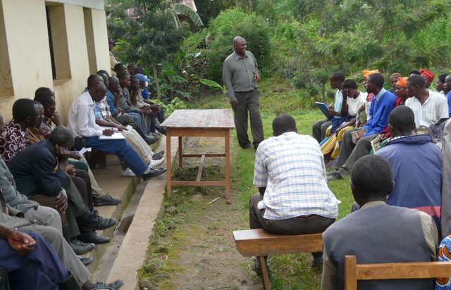
This approach is a contribution of different stakeholders and land users in the identification and resolution of a particular crop land problems, which implicate at the end different stage of intervention by all stakeholders to resolve the problem.
- Compiler: Desire Kagabo
2. Description of the SLM Technology
2.1 Short description of the Technology
Definition of the Technology:
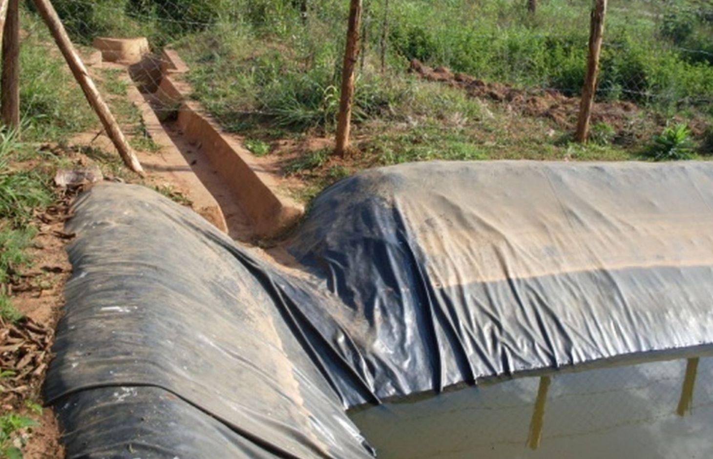
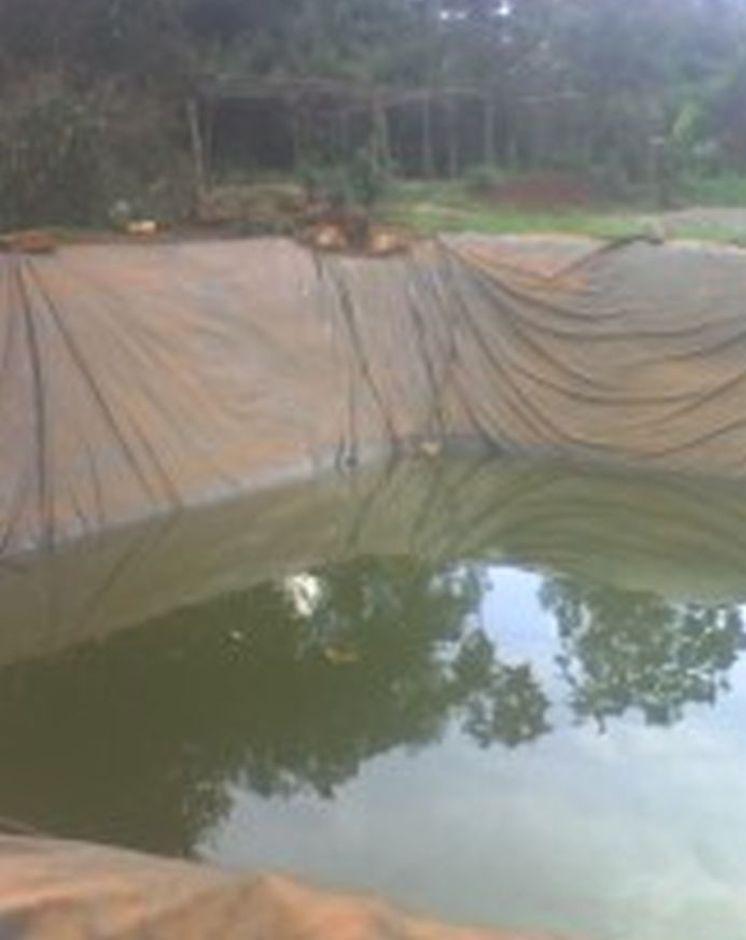
Lining geomembrane plastic for water harvesting and storage is a rainwater harvesting technique used by land users to collect rain water or runoff from a concave watershed to a common well-structured plastic-lined pond for agricultural, domestic and other use.
2.2 Detailed description of the Technology
Description:
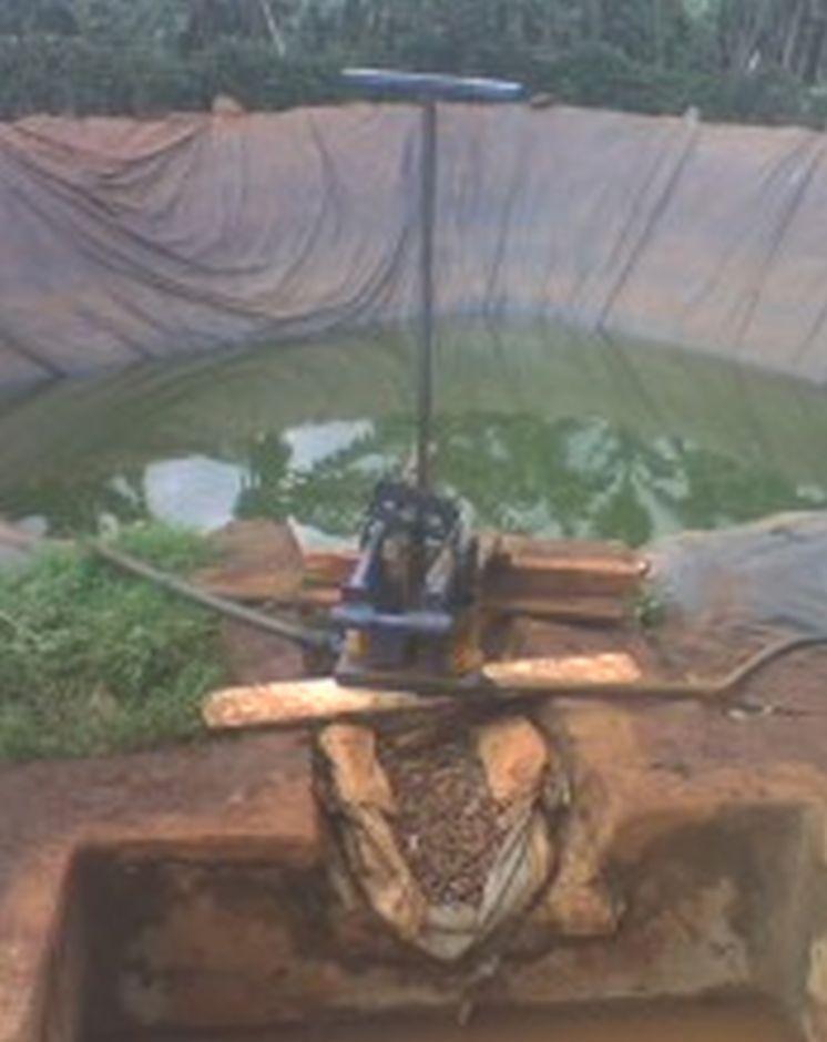
Rainwater harvesting initiatives were introduced in Rwanda in 2007, through a government-supported project on a pilot basis in three districts (Ruhango, Bugesera and Kirehe). By 2011, the technology had expanded at exponential rates such that the demand has exceeded the supply. Now the supply policy has shifted from government to private still there is a shortage of plastic lining. The typical design of each pond is trapezoidal in shape, measuring 10.5 by 9 meters top-width, 6.5 by 5 meters bottom width and 2 meters depth and a total storage volume about 120 m3. The plastic lining is factory–manufactured with standard shape and size to fit these dimensions. The ponds are made with this standard design to enable bulk purchase and supply of geo-membranes, to make use of economies of scale. The cost of the geo-membranes was subsidized by up to 100% by the government until 2010 but now only 20% are provided by the government. When this project was initiated, activities related to soil excavation was done by the government. However, with time the government pulled out and farmers are now covering the total cost of excavation and the government intervenes only for the technical compliance. The government provides technicians to train farmers on the safety and management of ponds. The volume of water harvested and stored in the ponds is on average 90 m3. However, water retention within the ponds over time differs with from farm to farm as affected by usage, evaporation and seepage losses. Treadle pumps are sometimes used to lift water by some of the farmers. Among most households, the water from the pond is used for domestic, livestock and supplemental irrigation, especially of horticultural crops. About 20% of the water is used for seedling and fruit production, 75% for livestock watering and 5% for domestic use. When the excavation of the pond is complete, the beds as well as sides of the pond have to be leveled and prepared for laying the lining plastic. Any rocks, large stones or other projections, which might damage the lining plastic, should be removed from the beds and sides of the excavated ponds.
Purpose of the Technology: Lining geomembrane plastic for water storage is designed to reduce seepage losses in ponds. This water is used by smallholder farmers to cope with the beginning of dry season and enhance crops to reach the maturity stage safely.
Establishment / maintenance activities and inputs: A periodical inspection is required for better life of the pond, thus timely maintenance hold the key of success for longer time. The maintenance includes inspection, repairing damages. Regular investigations are required on the pond sides, bottom, the inlet and the emergency outlet. In addition, the pond should be protected from intrusion of animals by constructing a fence around the pond. It is also important to remove aquatic vegetation, silt and sediment periodically that accumulate on the bottom of the pond.
2.3 Photos of the Technology
Media Gallery
2.5 Country/ region/ locations where the Technology has been applied and which are covered by this assessment
Country:
Rwanda
Region/ State/ Province:
Rwanda
Further specification of location:
Kayonza District (East provice)
Specify the spread of the Technology:
- evenly spread over an area
If precise area is not known, indicate approximate area covered:
- < 0.1 km2 (10 ha)
Comments:
The area was estimated.
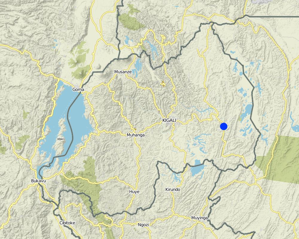
Map
×2.6 Date of implementation
If precise year is not known, indicate approximate date:
- less than 10 years ago (recently)
2.7 Introduction of the Technology
- Government
Comments (type of project, etc.):
the technology was initiated in 2008
3. Classification of the SLM Technology
3.1 Main purpose(s) of the Technology
- access to water
3.2 Current land use type(s) where the Technology is applied

Cropland
- Annual cropping
Annual cropping - Specify crops:
- cereals - maize
- legumes and pulses - beans
- vegetables - other
Specify:
Longest growing period in days: 150; Longest growing period from month to month: September – February; Second longest growing period in days: 120; Second longest growing period from month to month: March – July
Comments:
major cash crop: Vegetables
major food crop: Beans
other: Maize
Major land use problems (compiler’s opinion): There were poor yields of crops caused by elongation of dry season and increase of runoff soil erosion (intensive rain during rainy seasons) at the previous season.
Major land use problems (land users’ perception): Low crop production, soil erosion
Livestock is grazing on crop residues
3.4 Water supply
Water supply for the land on which the Technology is applied:
- mixed rainfed-irrigated
3.5 SLM group to which the Technology belongs
- water harvesting
3.6 SLM measures comprising the Technology

structural measures
- S5: Dams, pans, ponds
3.7 Main types of land degradation addressed by the Technology

soil erosion by water
- Wg: gully erosion/ gullying
- Wo: offsite degradation effects

water degradation
- Ha: aridification
Comments:
Secondary types of degradation addressed: Ha: aridification
Main causes of degradation: deforestation / removal of natural vegetation (incl. forest fires), other natural causes (avalanches, volcanic eruptions, mud flows, highly susceptible natural resources, extreme topography, etc.) specify (Steep slopes in many cases over 60%), population pressure (Rwanda’s natural resource is subject to a high density of population with an average of 400 people per ha)
Secondary causes of degradation: overgrazing, urbanisation and infrastructure development, poverty / wealth (Farmers have low income and have less access to off farm income or remittances), education, access to knowledge and support services (High rate of irriteracy)
3.8 Prevention, reduction, or restoration of land degradation
Specify the goal of the Technology with regard to land degradation:
- reduce land degradation
4. Technical specifications, implementation activities, inputs, and costs
4.1 Technical drawing of the Technology
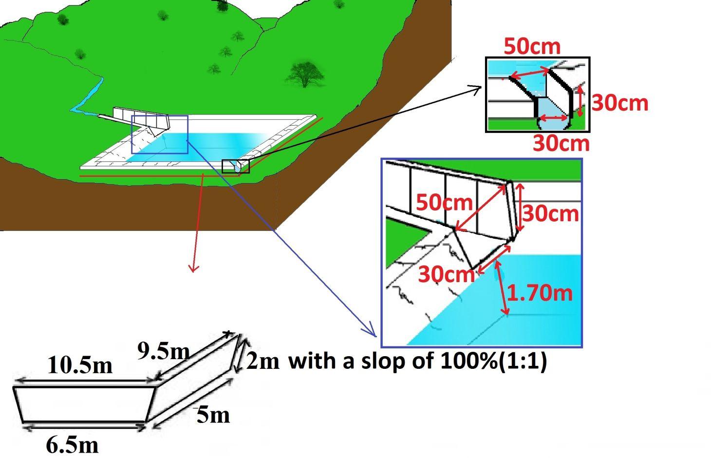
Technical specifications (related to technical drawing):
Surface runoff water storage pond have got a reservoir of 10.5m x 9.5m at top and 6.5m x 5m at bottom and a depth of 2m with side slope of 1:1.5. The capacity of one pond is estimated about 120m3.
Location: Kabarondo. Kayonza/West/Rwanda
Date: 2013
Technical knowledge required for field staff / advisors: high (The technology need skilled engineers)
Technical knowledge required for land users: moderate (It need moderately skilled labor to construct the technology under supervision of engineers.)
Main technical functions: control of concentrated runoff: retain / trap, water harvesting / increase water supply
Secondary technical functions: water spreading
Dam/ pan/ pond
Vertical interval between structures (m): 2
Spacing between structures (m): 20
Depth of ditches/pits/dams (m): 2
Width of ditches/pits/dams (m): 9.5
Length of ditches/pits/dams (m): 10.5
Construction material (earth): the original land is digging
Construction material (stone): stones are used to concrete the pond inlet and outlet
Construction material (concrete): Cements, sand
Construction material (other): fencing wire and waterproof steering(plastic sheet)
Lateral gradient along the structure: 0%
Specification of dams/ pans/ ponds: Capacity 120m3
Catchment area: 6ham2
Beneficial area: valleym2
Slope of dam wall inside: 50%;
Slope of dam wall outside: 50%
Dimensions of spillways: 0.8m x0.6mm
For water harvesting: the ratio between the area where the harvested water is applied and the total area from which water is collected is: 1:0.25
Author:
Kagabo Desire and Ngenzi Guy, RAB, 5016 Kigali
4.2 General information regarding the calculation of inputs and costs
other/ national currency (specify):
Rwandan francs
If relevant, indicate exchange rate from USD to local currency (e.g. 1 USD = 79.9 Brazilian Real): 1 USD =:
640.0
Indicate average wage cost of hired labour per day:
1000
4.3 Establishment activities
| Activity | Timing (season) | |
|---|---|---|
| 1. | Surveying | any time |
| 2. | Buying materials | Any time after surveying |
| 3. | Construction of pond | Dry season |
4.4 Costs and inputs needed for establishment
| Specify input | Unit | Quantity | Costs per Unit | Total costs per input | % of costs borne by land users | |
|---|---|---|---|---|---|---|
| Labour | Surveying | persons/day/ha | 4.0 | 45000.0 | 180000.0 | |
| Labour | Construction of pond | persons/day/ha | 180.0 | 1000.0 | 180000.0 | 80.0 |
| Equipment | Tools | pieces/ha | 100.0 | 3000.0 | 300000.0 | 20.0 |
| Construction material | Cements | kg | 300.0 | 200.0 | 60000.0 | |
| Construction material | Plastic sheet | m2 | 24.0 | 2500.0 | 60000.0 | |
| Construction material | Stone | m3 | 8.0 | 562.5 | 4500.0 | |
| Construction material | Sand | m3 | 8.0 | 390.625 | 3125.0 | |
| Construction material | Fencing wire | m2 | 24.0 | 625.0 | 15000.0 | |
| Total costs for establishment of the Technology | 802625.0 | |||||
| Total costs for establishment of the Technology in USD | 1254.1 | |||||
Comments:
Duration of establishment phase: 2 month(s)
4.5 Maintenance/ recurrent activities
| Activity | Timing/ frequency | |
|---|---|---|
| 1. | regular maintenance of Channels and all around the pond. | Rainy season |
4.6 Costs and inputs needed for maintenance/ recurrent activities (per year)
| Specify input | Unit | Quantity | Costs per Unit | Total costs per input | % of costs borne by land users | |
|---|---|---|---|---|---|---|
| Labour | Regular maintenance | persons/day/ha | 10.0 | 1000.0 | 10000.0 | 100.0 |
| Total costs for maintenance of the Technology | 10000.0 | |||||
| Total costs for maintenance of the Technology in USD | 15.63 | |||||
Comments:
Machinery/ tools: hoes, meter, clinomrter, ect....
4.7 Most important factors affecting the costs
Describe the most determinate factors affecting the costs:
The most factors that affects the cost is the construction materials and labor.
5. Natural and human environment
5.1 Climate
Annual rainfall
- < 250 mm
- 251-500 mm
- 501-750 mm
- 751-1,000 mm
- 1,001-1,500 mm
- 1,501-2,000 mm
- 2,001-3,000 mm
- 3,001-4,000 mm
- > 4,000 mm
Agro-climatic zone
- sub-humid
Thermal climate class: tropics
5.2 Topography
Slopes on average:
- flat (0-2%)
- gentle (3-5%)
- moderate (6-10%)
- rolling (11-15%)
- hilly (16-30%)
- steep (31-60%)
- very steep (>60%)
Landforms:
- plateau/plains
- ridges
- mountain slopes
- hill slopes
- footslopes
- valley floors
Altitudinal zone:
- 0-100 m a.s.l.
- 101-500 m a.s.l.
- 501-1,000 m a.s.l.
- 1,001-1,500 m a.s.l.
- 1,501-2,000 m a.s.l.
- 2,001-2,500 m a.s.l.
- 2,501-3,000 m a.s.l.
- 3,001-4,000 m a.s.l.
- > 4,000 m a.s.l.
5.3 Soils
Soil depth on average:
- very shallow (0-20 cm)
- shallow (21-50 cm)
- moderately deep (51-80 cm)
- deep (81-120 cm)
- very deep (> 120 cm)
Soil texture (topsoil):
- medium (loamy, silty)
- fine/ heavy (clay)
Topsoil organic matter:
- high (>3%)
- medium (1-3%)
If available, attach full soil description or specify the available information, e.g. soil type, soil PH/ acidity, Cation Exchange Capacity, nitrogen, salinity etc.
Soil fertility is medium - high
Soil drainage / infiltration is medium
Soil water storage capacity is very high - high
5.4 Water availability and quality
Ground water table:
5-50 m
Availability of surface water:
good
Water quality (untreated):
for agricultural use only (irrigation)
5.5 Biodiversity
Species diversity:
- medium
5.6 Characteristics of land users applying the Technology
Market orientation of production system:
- commercial/ market
Off-farm income:
- less than 10% of all income
Relative level of wealth:
- poor
- average
Individuals or groups:
- individual/ household
Level of mechanization:
- manual work
Gender:
- women
- men
Indicate other relevant characteristics of the land users:
Population density: 200-500 persons/km2
Annual population growth: 3% - 4%
55% of the land users are average wealthy and own 60% of the land.
45% of the land users are poor and own 40% of the land.
Market orientation of production system: (Begetables)
5.7 Average area of land used by land users applying the Technology
- < 0.5 ha
- 0.5-1 ha
- 1-2 ha
- 2-5 ha
- 5-15 ha
- 15-50 ha
- 50-100 ha
- 100-500 ha
- 500-1,000 ha
- 1,000-10,000 ha
- > 10,000 ha
Is this considered small-, medium- or large-scale (referring to local context)?
- small-scale
5.8 Land ownership, land use rights, and water use rights
Land ownership:
- individual, titled
Land use rights:
- individual
Water use rights:
- open access (unorganized)
- communal (organized)
5.9 Access to services and infrastructure
health:
- poor
- moderate
- good
education:
- poor
- moderate
- good
technical assistance:
- poor
- moderate
- good
employment (e.g. off-farm):
- poor
- moderate
- good
markets:
- poor
- moderate
- good
energy:
- poor
- moderate
- good
roads and transport:
- poor
- moderate
- good
drinking water and sanitation:
- poor
- moderate
- good
financial services:
- poor
- moderate
- good
6. Impacts and concluding statements
6.1 On-site impacts the Technology has shown
Socio-economic impacts
Production
crop production
Quantity before SLM:
200 kg
Quantity after SLM:
800 kg
risk of production failure
Quantity before SLM:
50%
Quantity after SLM:
10%
Income and costs
farm income
Quantity before SLM:
40%
Quantity after SLM:
80%
Comments/ specify:
40% of income increases due to increase of agriculture
Socio-cultural impacts
food security/ self-sufficiency
health situation
Comments/ specify:
The technology improved the productivity so that farmers had means to take health insurance
SLM/ land degradation knowledge
Comments/ specify:
Increases up to 15%
livelihood and human well-being
Comments/ specify:
It has increased income of household hence enhance life.
Ecological impacts
Water cycle/ runoff
harvesting/ collection of water
Comments/ specify:
60% improved
Soil
soil loss
Biodiversity: vegetation, animals
pest/ disease control
Quantity before SLM:
20%
Quantity after SLM:
50%
Comments/ specify:
It increases the predominance of mosquito
6.2 Off-site impacts the Technology has shown
downstream siltation
6.3 Exposure and sensitivity of the Technology to gradual climate change and climate-related extremes/ disasters (as perceived by land users)
Gradual climate change
Gradual climate change
| Season | increase or decrease | How does the Technology cope with it? | |
|---|---|---|---|
| annual temperature | increase | well |
Climate-related extremes (disasters)
Meteorological disasters
| How does the Technology cope with it? | |
|---|---|
| local rainstorm | not well |
| local windstorm | not known |
Climatological disasters
| How does the Technology cope with it? | |
|---|---|
| drought | well |
Hydrological disasters
| How does the Technology cope with it? | |
|---|---|
| general (river) flood | not well |
6.4 Cost-benefit analysis
How do the benefits compare with the establishment costs (from land users’ perspective)?
Short-term returns:
neutral/ balanced
Long-term returns:
very positive
How do the benefits compare with the maintenance/ recurrent costs (from land users' perspective)?
Short-term returns:
slightly positive
Long-term returns:
very positive
Comments:
It require light labor during the maintenance activities
6.5 Adoption of the Technology
- > 50%
If available, quantify (no. of households and/ or area covered):
260 household covering 90 percent of stated area
Of all those who have adopted the Technology, how many did so spontaneously, i.e. without receiving any material incentives/ payments?
- 0-10%
Comments:
250 land user families have adopted the Technology with external material support
10 land user families have adopted the Technology without any external material support
There is a little trend towards spontaneous adoption of the Technology
6.7 Strengths/ advantages/ opportunities of the Technology
| Strengths/ advantages/ opportunities in the compiler’s or other key resource person’s view |
|---|
|
Income generation How can they be sustained / enhanced? More financial support and trainings |
|
Improvement of production How can they be sustained / enhanced? To make a regular maintenance of ponds |
|
Soil erosion control How can they be sustained / enhanced? Divert more runoff to mitigate the soil erosion downstream and always clean the conveying channel. |
|
Impermeable material How can they be sustained / enhanced? Acquisition of high quality plastics that can last many years |
6.8 Weaknesses/ disadvantages/ risks of the Technology and ways of overcoming them
| Weaknesses/ disadvantages/ risks in the compiler’s or other key resource person’s view | How can they be overcome? |
|---|---|
| Occasional accidents | To maintain fences around the pond and increase awareness about accidents around a pond, especially for parents (high risk for small kids) |
| Pond attract various insects and diseases (habitat for Mosquitoes) | Mosquito nets are needed |
7. References and links
7.1 Methods/ sources of information
7.2 References to available publications
Title, author, year, ISBN:
Kagera TAMP project website
Available from where? Costs?
http://www.fao.org/nr/kagera/en/
Links and modules
Expand all Collapse allLinks
Participatory approach [Rwanda]
This approach is a contribution of different stakeholders and land users in the identification and resolution of a particular crop land problems, which implicate at the end different stage of intervention by all stakeholders to resolve the problem.
- Compiler: Desire Kagabo
Modules
No modules