Firebreaks [Senegal]
- Creation:
- Update:
- Compiler: Dieter Nill
- Editor: –
- Reviewers: Fabian Ottiger, Alexandra Gavilano
Pare-feux (French)
technologies_1615 - Senegal
View sections
Expand all Collapse all1. General information
1.2 Contact details of resource persons and institutions involved in the assessment and documentation of the Technology
SLM specialist:
Dorlöchter-Sulser Sabine
Misereor
Germany
SLM specialist:
Daniel André
Ministère des Eaux et Forêts, Senegal
Senegal
Name of project which facilitated the documentation/ evaluation of the Technology (if relevant)
Manual of Good Practices in Small Scale Irrigation in the Sahel (GIZ )Name of the institution(s) which facilitated the documentation/ evaluation of the Technology (if relevant)
Deutsche Gesellschaft für Internationale Zusammenarbeit (GIZ) - GermanyName of the institution(s) which facilitated the documentation/ evaluation of the Technology (if relevant)
Misereor - GermanyName of the institution(s) which facilitated the documentation/ evaluation of the Technology (if relevant)
Direction des Eaux et Forêts, Chasses et de la conservation des Sols - Senegal1.3 Conditions regarding the use of data documented through WOCAT
The compiler and key resource person(s) accept the conditions regarding the use of data documented through WOCAT:
Yes
2. Description of the SLM Technology
2.1 Short description of the Technology
Definition of the Technology:
Firebreaks cut vast tracts of rangeland into smaller areas, with a view to limiting damage in the event of wildfire.
2.2 Detailed description of the Technology
Description:
This technique is used on rangeland with rainfall between 150 and 300 mm. Firebreaks are a precautionary measure designed to protect forage on rangelands during the dry season. Bushfires are frequent on good-quality rangeland with over 1t/ha of biomass.
Purpose of the Technology: Firebreaks cut vast tracts of rangeland into smaller areas, with a view to limiting damage in the event of wildfire. They can also be established along traditional tracks. The gap in the vegetation makes it easier to put fires out along the corridor, which facilitates rapid access. When the fire reaches the firebreak, there is no combustible material to fuel it and it burns itself out.
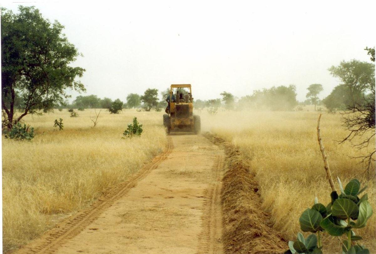
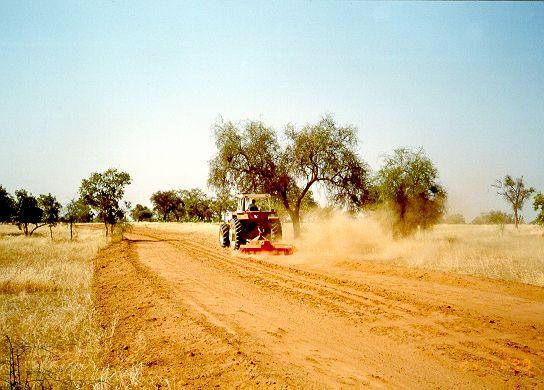
Establishment / maintenance activities and inputs: There are two techniques for creating firebreaks: (i) the manual method and (ii) the mechanised method. In both cases, a 10 to 15 m wide corridor is cleared perpendicular to the prevailing wind direction after the rainy season. Fires only poses a threat in the Sahel area in the dry season following a good rainy season when grass growth is good. The corridor is cleared of all herbaceous vegetation manually, using tools such as rakes, shovels and axes, or mechanically using a tractor pulling a large harrow, a four-wheel-drive vehicle pulling the blades behind it or graders. Trees are pruned, but left in place.
The sustainability of firebreaks depends on how well they are maintained. Once they have been created, they need to be cleared every year if grasses have grown over them again. If there is little vegetation growth, they can
be maintained once every two years or as required. If they are cleared manually, the communities or commune authorities must be well organised to ensure that the work is properly carried out. Good organisation is also required to ensure an effective response in the event of a fire (mobile unit).
2.3 Photos of the Technology
Media Gallery
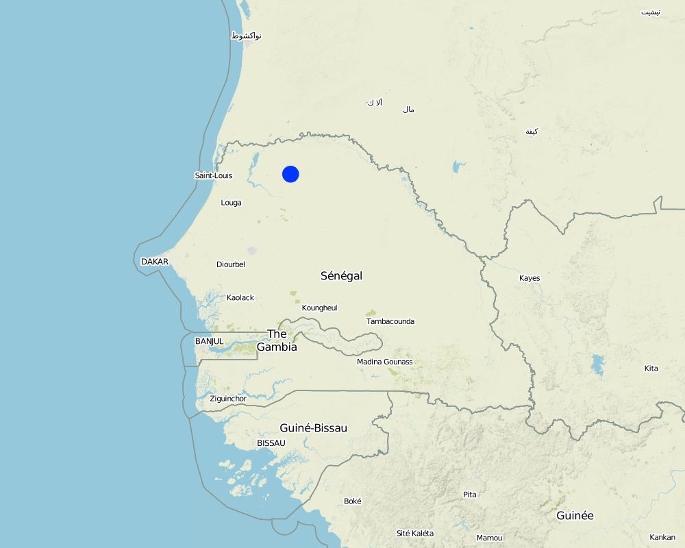
2.5 Country/ region/ locations where the Technology has been applied and which are covered by this assessment
Country:
Senegal
Region/ State/ Province:
Senegal
Further specification of location:
Ferlo Region
Specify the spread of the Technology:
- evenly spread over an area
If precise area is not known, indicate approximate area covered:
- 100-1,000 km2
Map
×2.6 Date of implementation
If precise year is not known, indicate approximate date:
- 10-50 years ago
2.7 Introduction of the Technology
Specify how the Technology was introduced:
- through projects/ external interventions
Comments (type of project, etc.):
Developed in other countries. Implemented and disseminated as part of projects and programmes undertaken from the 1980s onwards. Implemented by GIZ (German Federal Enterprise for International Cooperation): Projet PASP (Projet d‘Autopromotion Pastorale dans le Ferlo - Project to Promote Self-Help of Pastoralists in the Ferlo Region) in Northern Senegal.
3. Classification of the SLM Technology
3.1 Main purpose(s) of the Technology
- reduce risk of disasters
3.2 Current land use type(s) where the Technology is applied

Grazing land
Comments:
Major land use problems (compiler’s opinion): Bushfires are frequent on good-quality rangeland with over 1t/ha of biomass; bushfire only poses a threat in the Sahel area in the dry season following a good rainy season when grass growth is good.
Constraints of common grazing land
Constraints of forested government-owned land or commons
Number of growing seasons per year: 1
Longest growing period in days: 120 Longest growing period from month to month: August to October
3.5 SLM group to which the Technology belongs
- ecosystem-based disaster risk reduction
3.6 SLM measures comprising the Technology

vegetative measures
- V3: Clearing of vegetation
Comments:
Main measures: vegetative measures
3.7 Main types of land degradation addressed by the Technology

biological degradation
- Bc: reduction of vegetation cover
- Bf: detrimental effects of fires
Comments:
Main type of degradation addressed: Bf: detrimental effects of fires
Secondary types of degradation addressed: Bc: reduction of vegetation cover
Main causes of degradation: other human induced causes (specify) (man made fires, natural flashes during thunderstorms), droughts
3.8 Prevention, reduction, or restoration of land degradation
Specify the goal of the Technology with regard to land degradation:
- prevent land degradation
4. Technical specifications, implementation activities, inputs, and costs
4.1 Technical drawing of the Technology
Technical specifications (related to technical drawing):
Technical knowledge required for field staff / advisors: moderate
Technical knowledge required for land users: low
Main technical functions: control of fires, reduction of dry material (fuel for wildfires)
Vegetative measure: clearing of vegetation
Vegetative material: G : grass
Vegetative measure: Vegetative material: G : grass
Vegetative measure: Vegetative material: G : grass
Vegetative measure: Vegetative material: G : grass
4.3 Establishment activities
| Activity | Timing (season) | |
|---|---|---|
| 1. | A 10 to 15 m wide corridor is cleared perpendicular to the prevailing wind direction after the rainy season of all herbaceous vegetation manually, using tools such as rakes, shovels and axes, or mechanically using a tractor pulling a large harrow, a four- wheel-drive vehicle pulling the blades behind it or graders. | |
| 2. | Trees are pruned, but left in place |
4.5 Maintenance/ recurrent activities
| Activity | Timing/ frequency | |
|---|---|---|
| 1. | Once they have been created, they need to be cleared every year if grasses have grown over them again. If there is little vegetation growth, they can be maintained once every two years or as required. |
4.7 Most important factors affecting the costs
Describe the most determinate factors affecting the costs:
Manual method:
• equipment, such as rakes, shovels and axes
• labour.
Mechanised method:
• four-wheel-drive vehicle, tractor or land grader
• harrow
• labour to clear the corridor.
5. Natural and human environment
5.1 Climate
Annual rainfall
- < 250 mm
- 251-500 mm
- 501-750 mm
- 751-1,000 mm
- 1,001-1,500 mm
- 1,501-2,000 mm
- 2,001-3,000 mm
- 3,001-4,000 mm
- > 4,000 mm
Agro-climatic zone
- semi-arid
Thermal climate class: subtropics
5.2 Topography
Slopes on average:
- flat (0-2%)
- gentle (3-5%)
- moderate (6-10%)
- rolling (11-15%)
- hilly (16-30%)
- steep (31-60%)
- very steep (>60%)
Landforms:
- plateau/plains
- ridges
- mountain slopes
- hill slopes
- footslopes
- valley floors
Altitudinal zone:
- 0-100 m a.s.l.
- 101-500 m a.s.l.
- 501-1,000 m a.s.l.
- 1,001-1,500 m a.s.l.
- 1,501-2,000 m a.s.l.
- 2,001-2,500 m a.s.l.
- 2,501-3,000 m a.s.l.
- 3,001-4,000 m a.s.l.
- > 4,000 m a.s.l.
Comments and further specifications on topography:
Slopes on average: Also moderate (6-10%)
5.3 Soils
Soil depth on average:
- very shallow (0-20 cm)
- shallow (21-50 cm)
- moderately deep (51-80 cm)
- deep (81-120 cm)
- very deep (> 120 cm)
Soil texture (topsoil):
- medium (loamy, silty)
- fine/ heavy (clay)
If available, attach full soil description or specify the available information, e.g. soil type, soil PH/ acidity, Cation Exchange Capacity, nitrogen, salinity etc.
Soil fertility: Medium and low
Soil drainage/infiltration: Medium and poor
Soil water storage capacity: Medium and low
5.4 Water availability and quality
Ground water table:
5-50 m
Availability of surface water:
medium
Comments and further specifications on water quality and quantity:
Ground water table: 5-50m ( > 10 m)
Availability of surface water: Medium (surface runoff generated by limited but intense rainfalls)
5.5 Biodiversity
Species diversity:
- low
5.6 Characteristics of land users applying the Technology
Relative level of wealth:
- very poor
- poor
Gender:
- men
Indicate other relevant characteristics of the land users:
Population density: 10-50 persons/km2
Annual population growth: 3% - 4%
(mostly poor households below poverty line).
Off-farm income specification: men migrate temporarily or permanently to cities for off-farm income
5.7 Average area of land used by land users applying the Technology
- < 0.5 ha
- 0.5-1 ha
- 1-2 ha
- 2-5 ha
- 5-15 ha
- 15-50 ha
- 50-100 ha
- 100-500 ha
- 500-1,000 ha
- 1,000-10,000 ha
- > 10,000 ha
Is this considered small-, medium- or large-scale (referring to local context)?
- small-scale
5.8 Land ownership, land use rights, and water use rights
Land ownership:
- state
Land use rights:
- communal (organized)
Water use rights:
- communal (organized)
Comments:
traditional land use rights on fields, communal land on pasture and forest land
5.9 Access to services and infrastructure
health:
- poor
- moderate
- good
education:
- poor
- moderate
- good
technical assistance:
- poor
- moderate
- good
employment (e.g. off-farm):
- poor
- moderate
- good
markets:
- poor
- moderate
- good
energy:
- poor
- moderate
- good
roads and transport:
- poor
- moderate
- good
drinking water and sanitation:
- poor
- moderate
- good
financial services:
- poor
- moderate
- good
6. Impacts and concluding statements
6.1 On-site impacts the Technology has shown
Socio-economic impacts
Production
risk of production failure
Income and costs
workload
Other socio-economic impacts
Establishment and maintenance costs
Socio-cultural impacts
conflict mitigation
Improved livelihoods and human well-being
Comments/ specify:
Preventing wildfire contributes to safeguarding the fauna and flora over vast tracts of rangeland, which would otherwise be destroyed. It also avoids enormous economic losses in terms of livestock and infrastructure (herding villages, forage). When rangelands remain intact, nomadic livestock keepers tend to stay within their area.
Ecological impacts
Climate and disaster risk reduction
emission of carbon and greenhouse gases
fire risk
6.3 Exposure and sensitivity of the Technology to gradual climate change and climate-related extremes/ disasters (as perceived by land users)
Gradual climate change
Gradual climate change
| Season | increase or decrease | How does the Technology cope with it? | |
|---|---|---|---|
| annual temperature | increase | well |
Climate-related extremes (disasters)
Meteorological disasters
| How does the Technology cope with it? | |
|---|---|
| local rainstorm | well |
| local windstorm | well |
Climatological disasters
| How does the Technology cope with it? | |
|---|---|
| drought | well |
Hydrological disasters
| How does the Technology cope with it? | |
|---|---|
| general (river) flood | well |
Other climate-related consequences
Other climate-related consequences
| How does the Technology cope with it? | |
|---|---|
| reduced growing period | well |
6.4 Cost-benefit analysis
How do the benefits compare with the establishment costs (from land users’ perspective)?
Short-term returns:
positive
Long-term returns:
positive
How do the benefits compare with the maintenance/ recurrent costs (from land users' perspective)?
Short-term returns:
slightly positive
Long-term returns:
slightly positive
Comments:
Both the short-term and the long-term benefits are very positive assuming that maintenance is done.
6.5 Adoption of the Technology
If available, quantify (no. of households and/ or area covered):
100% of the area covered
Of all those who have adopted the Technology, how many did so spontaneously, i.e. without receiving any material incentives/ payments?
- 0-10%
Comments:
100% of land user families have adopted the Technology with external material support
Comments on acceptance with external material support: Fire breaks are economically viable but investment is high and generally asks for public investment. Cost sharing of beneficiaries has to be decided locally based on local conditions.
There is no trend towards spontaneous adoption of the Technology
Comments on adoption trend: Asks for strong commitment of either beneficiaries and or local government.
6.7 Strengths/ advantages/ opportunities of the Technology
| Strengths/ advantages/ opportunities in the compiler’s or other key resource person’s view |
|---|
|
Preventing wildfire contributes to safeguarding the fauna and flora over vast tracts of rangeland, which would otherwise be destroyed. How can they be sustained / enhanced? The sustainability of firebreaks depends on how well they are maintained. Once they have been created, they need to be cleared every year if grasses have grown over them again. If there is little vegetation growth, they can be maintained once every two years or as required. If they are cleared manually, the communities or commune authorities must be well organised to ensure that the work is properly carried out. Good organisation is also required to ensure an effective response in the event of a fire (mobile unit). |
| It also avoids enormous economic losses in terms of livestock and infrastructure (herding villages, forage). When rangelands remain intact, nomadic livestock keepers tend to stay within their area. |
6.8 Weaknesses/ disadvantages/ risks of the Technology and ways of overcoming them
| Weaknesses/ disadvantages/ risks in the compiler’s or other key resource person’s view | How can they be overcome? |
|---|---|
| The lack of financial and logistic resources is a constraint on the creation of firebreaks, and it is often difficult to organise the beneficiaries (nomadic livestock keepers) asked to participate financially or physically in the work required to establish and maintain them. | Once the financing has been secured, considerable efforts are required to raise awareness about the need to prevent fires and mobilise the livestock keepers in a particular grazing area to become involved in the work. |
7. References and links
7.1 Methods/ sources of information
7.3 Links to relevant online information
Title/ description:
Good Practices in Soil and Water Conservation. A contribution to adaptation and farmers´ resilience towards climate change in the Sahel. Published by GIZ in 2012.
URL:
http://agriwaterpedia.info/wiki/Main_Page
Links and modules
Expand all Collapse allLinks
No links
Modules
No modules