Firebreaks/ Greenbreaks [Philippines]
- Creation:
- Update:
- Compiler: Philippine Overview of Conservation Approaches and Technologies
- Editor: –
- Reviewers: Fabian Ottiger, Alexandra Gavilano
technologies_1705 - Philippines
View sections
Expand all Collapse all1. General information
1.2 Contact details of resource persons and institutions involved in the assessment and documentation of the Technology
Key resource person(s)
SLM specialist:
Padilla Alberto
Danao Municipality, Local Government Unit
Philippines
SLM specialist:
Dacumos Evangeline
Department of Agriculture-Bureau of Soils and Water Management
Philippines
SLM specialist:
Espanto Patrick Benson
Department of Agriculture-Bureau of Soils and Water Management
Philippines
SLM specialist:
Dinamling Djolly Ma
Department of Agriculture-Bureau of Soils and Water Management
Philippines
SLM specialist:
Castillo Forester Emma
Department of Environment and Natural Resources-Forest Management Bureau
Philippines
Name of the institution(s) which facilitated the documentation/ evaluation of the Technology (if relevant)
Bureau of Soils and Water Management (Bureau of Soils and Water Management) - PhilippinesName of the institution(s) which facilitated the documentation/ evaluation of the Technology (if relevant)
Danao Municipality - PhilippinesName of the institution(s) which facilitated the documentation/ evaluation of the Technology (if relevant)
Forest Management Bureau (Forest Management Bureau) - Philippines1.3 Conditions regarding the use of data documented through WOCAT
The compiler and key resource person(s) accept the conditions regarding the use of data documented through WOCAT:
Yes
1.5 Reference to Questionnaire(s) on SLM Approaches (documented using WOCAT)
Assisted Natural Regeneration (ANR) [Philippines]
A process of rehabilitating degraded forest lands by taking advantage of trees already growing in the area.
- Compiler: Philippine Overview of Conservation Approaches and Technologies
2. Description of the SLM Technology
2.1 Short description of the Technology
Definition of the Technology:
Gaps in vegetation or other combustible material that act as barriers to prevent and/ or control the spreading of forest fires to other areas.
2.2 Detailed description of the Technology
Description:
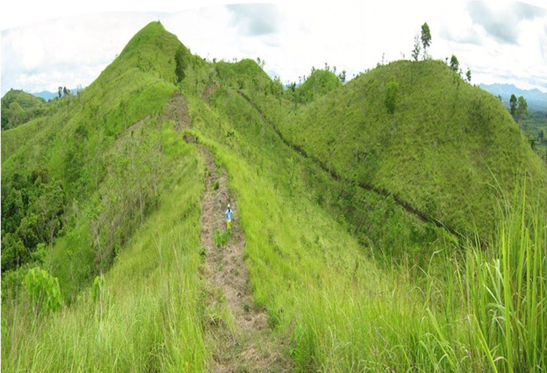
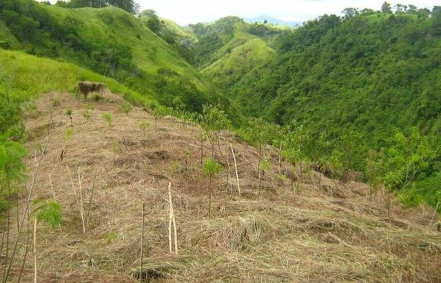
Firebreaks are 1,000-meter long, ten meters wide, located in the periphery/boundary and/or top of the ridge as barriers to slow or stop the progress of a fire. Greenbreaks are formed within the firebreaks by planting fire-resistant species in the gap portions such as kakawate (Gliricidia sepium), banana (Musa) abaca (Musa textilis), malunggay (Moringa oleifera), and cassava (Manihot esculenta). As a practice, fire breaks are established in every ten hectares to form a block, but it can vary depending on the slope of the area. Fires tend to spread quickly in higher slopes compared to flat areas, thus, more firebreaks are recommended.
Purpose of the Technology: Firebreaks/greenbreaks are established to protect the forest trees and wildlings from disturbances and wildfire. In case of forest fire, firebreaks/green breaks prevent the spread of fire from one block to another. Wildlings are seedlings derived from seeds scattered by birds, insects, animals and wind without human intervention, and allowed to grow naturally in the forest. The green breaks are planted with cash crops as immediate source of food and additional income for the land users.
Establishment / maintenance activities and inputs: The first step in creating fire breaks is the removal of all combustible materials such as deadwoods and cogon grasses (Imperata cylindrica) by using hoe or plow. Then, fire-resistant plant species such as kakawate (Gliricidia sepium) cuttings (i.e. 1-meter high) are staked at 1.5- meter spacing on both sides of the 10-meter wide firebreak. Kakawate is the preferred plant species because the leaves have high Nitrogen content and resistant to fire and drought. Maintenance of firebreaks/green breaks is done before the onset of the dry season. It is done through brushing of invasive weeds and plating of root crops. The pruning of kakawate is done every three years." Bayanihan" (rotational schedule of labour), a traditional communal concept of voluntary work is practiced during the establishment of the technology.
Natural / human environment: The area is part of the forest reserve in Danao, Bohol primarily intended for nature conservation and protection. It is about 100-500 m.a.s.l with moderately rolling to hilly slopes. It is under humid tropics climate with an average annual rainfall of 1500-2000 mm per year. The soil is loam, shallow depth, low fertility, with good drainage and medium water storage capacity. The area has high biodiversity as indicated by the presence of different indigenous trees and plants species, and wild animals and birds. The land users who apply the technology are small-holder farmers.These are members of a local cooperative. The population density is about 10-50 persons per sq. km. Since extraction of resources from the forest is prohibited, off-farm income is very important to the land users. Access to basic services and infrastructures are low.
2.3 Photos of the Technology
Media Gallery
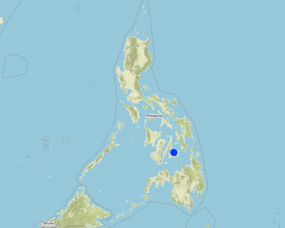
2.5 Country/ region/ locations where the Technology has been applied and which are covered by this assessment
Country:
Philippines
Region/ State/ Province:
Brgy. San Miguel
Further specification of location:
Danao, Bohol
Specify the spread of the Technology:
- evenly spread over an area
If the Technology is evenly spread over an area, specify area covered (in km2):
3.6
If precise area is not known, indicate approximate area covered:
- 1-10 km2
Comments:
Total area covered by the SLM Technology is 3.6 km2.
Map
×2.6 Date of implementation
If precise year is not known, indicate approximate date:
- more than 50 years ago (traditional)
2.7 Introduction of the Technology
- DENR (Department of Environment and Natural Resources) protocol on reforestration
3. Classification of the SLM Technology
3.2 Current land use type(s) where the Technology is applied

Forest/ woodlands
- Tree regeneration
Products and services:
- Fruits and nuts
- Other forest products
Comments:
Major land use problems (compiler’s opinion): Forest fire, competition with weedy species
Major land use problems (land users’ perception): spread of invasive alien species
Other type of forest: tree regeneration
Problems / comments regarding forest use: Increase of biodiversity (Wildlife)
Forest products and services: fruits and nuts, other forest products / uses (honey, medical, etc.)
Number of growing seasons per year: 2
3.5 SLM group to which the Technology belongs
- natural and semi-natural forest management
- Firebreak
3.6 SLM measures comprising the Technology

vegetative measures
- V3: Clearing of vegetation
- V5: Others
Comments:
Main measures: vegetative measures
Specification of other vegetative measures: Pruning of kakawate, root crop planting
Type of vegetative measures: aligned: -along boundary
3.7 Main types of land degradation addressed by the Technology

biological degradation
- Bc: reduction of vegetation cover
- Bh: loss of habitats
- Bf: detrimental effects of fires
Comments:
Main type of degradation addressed: Bf: detrimental effects of fires
Secondary types of degradation addressed: Bc: reduction of vegetation cover, Bh: loss of habitats
Main causes of degradation: deforestation / removal of natural vegetation (incl. forest fires)
3.8 Prevention, reduction, or restoration of land degradation
Specify the goal of the Technology with regard to land degradation:
- prevent land degradation
Comments:
Main goals: prevention of land degradation
4. Technical specifications, implementation activities, inputs, and costs
4.1 Technical drawing of the Technology
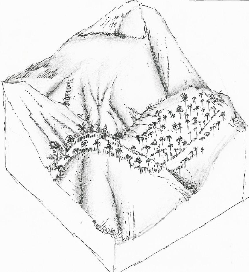
Technical specifications (related to technical drawing):
Firelines established in the ANR site.
Location: Barangay San Miguel. Danao, Bohol
Date: June 10, 2015
Technical knowledge required for field staff / advisors: moderate
Technical knowledge required for land users: moderate
Main technical functions: control of fires, reduction of dry material (fuel for wildfires)
Secondary technical functions: stabilisation of soil (eg by tree roots against land slides), sediment retention / trapping, sediment harvesting, increase of biomass (quantity), perimeter dirt road
Aligned: -along boundary
Vegetative material: T : trees / shrubs
Vertical interval within rows / strips / blocks (m): 1.5
Width within rows / strips / blocks (m): 10
Trees/ shrubs species: Kakawate trees
Author:
Mr. Patricio A. Yambot, Bureau of Soils and Water Management
4.3 Establishment activities
| Activity | Timing (season) | |
|---|---|---|
| 1. | clearing of cogon grass in the firelines | February |
| 2. | Planting of kakawate cuttings | on set of rainy season |
4.4 Costs and inputs needed for establishment
| Specify input | Unit | Quantity | Costs per Unit | Total costs per input | % of costs borne by land users | |
|---|---|---|---|---|---|---|
| Labour | clearing of cogon grass in the firelines and Planting of kakawate cuttings | ha | 1.0 | 26.66 | 26.66 | 100.0 |
| Total costs for establishment of the Technology | 26.66 | |||||
| Total costs for establishment of the Technology in USD | 26.66 | |||||
Comments:
Duration of establishment phase: 3 month(s)
4.5 Maintenance/ recurrent activities
| Activity | Timing/ frequency | |
|---|---|---|
| 1. | brushing/clearing | Every after 4 months |
| 2. | Pruning of kakawate/per year | every 3 years |
4.6 Costs and inputs needed for maintenance/ recurrent activities (per year)
| Specify input | Unit | Quantity | Costs per Unit | Total costs per input | % of costs borne by land users | |
|---|---|---|---|---|---|---|
| Labour | brushing/clearing as well as pruning of kakawate/per year | ha | 1.0 | 31.1 | 31.1 | 100.0 |
| Total costs for maintenance of the Technology | 31.1 | |||||
| Total costs for maintenance of the Technology in USD | 31.1 | |||||
5. Natural and human environment
5.1 Climate
Annual rainfall
- < 250 mm
- 251-500 mm
- 501-750 mm
- 751-1,000 mm
- 1,001-1,500 mm
- 1,501-2,000 mm
- 2,001-3,000 mm
- 3,001-4,000 mm
- > 4,000 mm
Agro-climatic zone
- humid
Thermal climate class: tropics
5.2 Topography
Slopes on average:
- flat (0-2%)
- gentle (3-5%)
- moderate (6-10%)
- rolling (11-15%)
- hilly (16-30%)
- steep (31-60%)
- very steep (>60%)
Landforms:
- plateau/plains
- ridges
- mountain slopes
- hill slopes
- footslopes
- valley floors
Altitudinal zone:
- 0-100 m a.s.l.
- 101-500 m a.s.l.
- 501-1,000 m a.s.l.
- 1,001-1,500 m a.s.l.
- 1,501-2,000 m a.s.l.
- 2,001-2,500 m a.s.l.
- 2,501-3,000 m a.s.l.
- 3,001-4,000 m a.s.l.
- > 4,000 m a.s.l.
Comments and further specifications on topography:
Altitudinal zone: 101-500 m a.s.l. (220m)
5.3 Soils
Soil depth on average:
- very shallow (0-20 cm)
- shallow (21-50 cm)
- moderately deep (51-80 cm)
- deep (81-120 cm)
- very deep (> 120 cm)
Soil texture (topsoil):
- medium (loamy, silty)
Topsoil organic matter:
- medium (1-3%)
If available, attach full soil description or specify the available information, e.g. soil type, soil PH/ acidity, Cation Exchange Capacity, nitrogen, salinity etc.
Soil vertility is medium
Soil drainage/infiltration is medium
Soil water storage capacity is medium
5.4 Water availability and quality
Ground water table:
< 5 m
Availability of surface water:
medium
5.5 Biodiversity
Species diversity:
- high
5.6 Characteristics of land users applying the Technology
Market orientation of production system:
- subsistence (self-supply)
Relative level of wealth:
- poor
Individuals or groups:
- employee (company, government)
Gender:
- women
- men
Indicate other relevant characteristics of the land users:
Land users applying the Technology are mainly common / average land users
Population density: 10-50 persons/km2
Annual population growth: 1% - 2%; 1%
100% of the land users are poor and own 100% of the land.
Market orientation of production system: Forest conservation and self subsistence ( Green breaks planted as cash crop )
5.7 Average area of land used by land users applying the Technology
- < 0.5 ha
- 0.5-1 ha
- 1-2 ha
- 2-5 ha
- 5-15 ha
- 15-50 ha
- 50-100 ha
- 100-500 ha
- 500-1,000 ha
- 1,000-10,000 ha
- > 10,000 ha
Is this considered small-, medium- or large-scale (referring to local context)?
- medium-scale
Comments:
Average: 75 ha
5.8 Land ownership, land use rights, and water use rights
Land ownership:
- state
Land use rights:
- open access (unorganized)
5.9 Access to services and infrastructure
health:
- poor
- moderate
- good
education:
- poor
- moderate
- good
technical assistance:
- poor
- moderate
- good
employment (e.g. off-farm):
- poor
- moderate
- good
markets:
- poor
- moderate
- good
energy:
- poor
- moderate
- good
roads and transport:
- poor
- moderate
- good
drinking water and sanitation:
- poor
- moderate
- good
6. Impacts and concluding statements
6.1 On-site impacts the Technology has shown
Socio-economic impacts
Production
fodder production
wood production
Income and costs
workload
Socio-cultural impacts
community institutions
conflict mitigation
Improved livelihoods and human well-being
Comments/ specify:
Through the technology, People's Organization (PO) members were encouraged to plant cash crops as greenbreaks as an immediate source of food and additional income.
Ecological impacts
Water cycle/ runoff
surface runoff
Biodiversity: vegetation, animals
plant diversity
habitat diversity
Climate and disaster risk reduction
emission of carbon and greenhouse gases
fire risk
6.2 Off-site impacts the Technology has shown
damage on public/ private infrastructure
6.3 Exposure and sensitivity of the Technology to gradual climate change and climate-related extremes/ disasters (as perceived by land users)
Gradual climate change
Gradual climate change
| Season | increase or decrease | How does the Technology cope with it? | |
|---|---|---|---|
| annual temperature | increase | well |
Climate-related extremes (disasters)
Meteorological disasters
| How does the Technology cope with it? | |
|---|---|
| local rainstorm | not known |
| local windstorm | not known |
Climatological disasters
| How does the Technology cope with it? | |
|---|---|
| drought | well |
Other climate-related consequences
Other climate-related consequences
| How does the Technology cope with it? | |
|---|---|
| reduced growing period | not known |
6.4 Cost-benefit analysis
How do the benefits compare with the establishment costs (from land users’ perspective)?
Short-term returns:
slightly negative
Long-term returns:
positive
How do the benefits compare with the maintenance/ recurrent costs (from land users' perspective)?
Short-term returns:
positive
Long-term returns:
positive
6.5 Adoption of the Technology
- > 50%
Of all those who have adopted the Technology, how many did so spontaneously, i.e. without receiving any material incentives/ payments?
- 0-10%
Comments:
100% of land user families have adopted the Technology with external material support
Comments on acceptance with external material support: The Department of Environment and Natural Resources (DENR) provided financial and technical support in the establishment of the technology.
Comments on spontaneous adoption: No spontaneous adoption was recorded without the support of the government (DENR) or private agencies.
6.7 Strengths/ advantages/ opportunities of the Technology
| Strengths/ advantages/ opportunities in the land user’s view |
|---|
|
The technology does not require heavy equipment and instrument during the establishment How can they be sustained / enhanced? Use of indigenous tools during establishment such as hoe and plows |
| Strengths/ advantages/ opportunities in the compiler’s or other key resource person’s view |
|---|
|
Relative small financial input in the establishment of the technology How can they be sustained / enhanced? Regular clearing of firebreaks |
6.8 Weaknesses/ disadvantages/ risks of the Technology and ways of overcoming them
| Weaknesses/ disadvantages/ risks in the compiler’s or other key resource person’s view | How can they be overcome? |
|---|---|
| Fires could cross on the firebreaks because of big and overlapping canopies. | Regular trimming on the canopies of trees near the firelines and brushing of weeds/grasses. |
7. References and links
7.1 Methods/ sources of information
Links and modules
Expand all Collapse allLinks
Assisted Natural Regeneration (ANR) [Philippines]
A process of rehabilitating degraded forest lands by taking advantage of trees already growing in the area.
- Compiler: Philippine Overview of Conservation Approaches and Technologies
Modules
No modules