Firebreaks/ Greenbreaks [ฟิลิปปินส์]
- ผู้สร้างสรรค์:
- การอัพเดท:
- ผู้รวบรวม: Philippine Overview of Conservation Approaches and Technologies
- ผู้เรียบเรียง: –
- ผู้ตรวจสอบ: Fabian Ottiger, Alexandra Gavilano
technologies_1705 - ฟิลิปปินส์
ดูส่วนย่อย
ขยายทั้งหมด ย่อทั้งหมด1. ข้อมูลทั่วไป
1.2 รายละเอียดที่ติดต่อได้ของผู้รวบรวมและองค์กรที่เกี่ยวข้องในการประเมินและการจัดเตรียมทำเอกสารของเทคโนโลยี
วิทยากรหลัก
ผู้เชี่ยวชาญ SLM:
Padilla Alberto
Danao Municipality, Local Government Unit
ฟิลิปปินส์
ผู้เชี่ยวชาญ SLM:
Dacumos Evangeline
Department of Agriculture-Bureau of Soils and Water Management
ฟิลิปปินส์
ผู้เชี่ยวชาญ SLM:
Espanto Patrick Benson
Department of Agriculture-Bureau of Soils and Water Management
ฟิลิปปินส์
ผู้เชี่ยวชาญ SLM:
Dinamling Djolly Ma
Department of Agriculture-Bureau of Soils and Water Management
ฟิลิปปินส์
ผู้เชี่ยวชาญ SLM:
Castillo Forester Emma
Department of Environment and Natural Resources-Forest Management Bureau
ฟิลิปปินส์
ชื่อขององค์กรซึ่งอำนวยความสะดวกในการทำเอกสารหรือการประเมินเทคโนโลยี (ถ้าเกี่ยวข้อง)
Bureau of Soils and Water Management (Bureau of Soils and Water Management) - ฟิลิปปินส์ชื่อขององค์กรซึ่งอำนวยความสะดวกในการทำเอกสารหรือการประเมินเทคโนโลยี (ถ้าเกี่ยวข้อง)
Danao Municipality - ฟิลิปปินส์ชื่อขององค์กรซึ่งอำนวยความสะดวกในการทำเอกสารหรือการประเมินเทคโนโลยี (ถ้าเกี่ยวข้อง)
Forest Management Bureau (Forest Management Bureau) - ฟิลิปปินส์1.3 เงื่อนไขการใช้ข้อมูลที่ได้บันทึกผ่านทาง WOCAT
ผู้รวบรวมและวิทยากรหลักยอมรับเงื่อนไขเกี่ยวกับการใช้ข้อมูลที่ถูกบันทึกผ่านทาง WOCAT:
ใช่
1.5 Reference to Questionnaire(s) on SLM Approaches (documented using WOCAT)
Assisted Natural Regeneration (ANR) [ฟิลิปปินส์]
A process of rehabilitating degraded forest lands by taking advantage of trees already growing in the area.
- ผู้รวบรวม: Philippine Overview of Conservation Approaches and Technologies
2. การอธิบายลักษณะของเทคโนโลยี SLM
2.1 การอธิบายแบบสั้น ๆ ของเทคโนโลยี
คำจำกัดความของเทคโนโลยี:
Gaps in vegetation or other combustible material that act as barriers to prevent and/ or control the spreading of forest fires to other areas.
2.2 การอธิบายแบบละเอียดของเทคโนโลยี
คำอธิบาย:
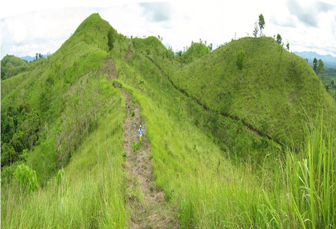
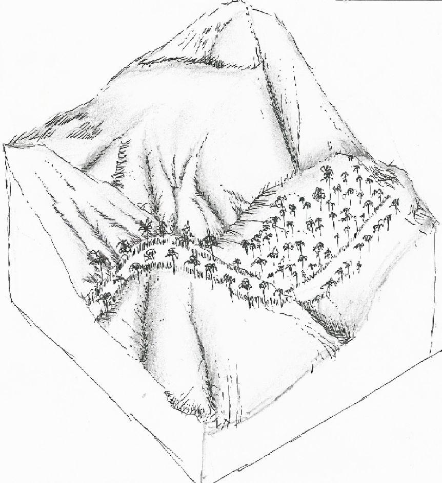
Firebreaks are 1,000-meter long, ten meters wide, located in the periphery/boundary and/or top of the ridge as barriers to slow or stop the progress of a fire. Greenbreaks are formed within the firebreaks by planting fire-resistant species in the gap portions such as kakawate (Gliricidia sepium), banana (Musa) abaca (Musa textilis), malunggay (Moringa oleifera), and cassava (Manihot esculenta). As a practice, fire breaks are established in every ten hectares to form a block, but it can vary depending on the slope of the area. Fires tend to spread quickly in higher slopes compared to flat areas, thus, more firebreaks are recommended.
Purpose of the Technology: Firebreaks/greenbreaks are established to protect the forest trees and wildlings from disturbances and wildfire. In case of forest fire, firebreaks/green breaks prevent the spread of fire from one block to another. Wildlings are seedlings derived from seeds scattered by birds, insects, animals and wind without human intervention, and allowed to grow naturally in the forest. The green breaks are planted with cash crops as immediate source of food and additional income for the land users.
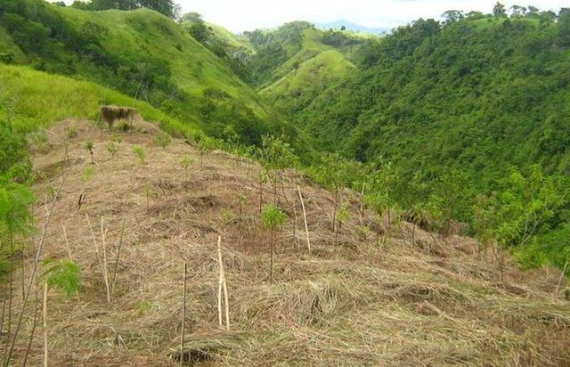
Establishment / maintenance activities and inputs: The first step in creating fire breaks is the removal of all combustible materials such as deadwoods and cogon grasses (Imperata cylindrica) by using hoe or plow. Then, fire-resistant plant species such as kakawate (Gliricidia sepium) cuttings (i.e. 1-meter high) are staked at 1.5- meter spacing on both sides of the 10-meter wide firebreak. Kakawate is the preferred plant species because the leaves have high Nitrogen content and resistant to fire and drought. Maintenance of firebreaks/green breaks is done before the onset of the dry season. It is done through brushing of invasive weeds and plating of root crops. The pruning of kakawate is done every three years." Bayanihan" (rotational schedule of labour), a traditional communal concept of voluntary work is practiced during the establishment of the technology.
Natural / human environment: The area is part of the forest reserve in Danao, Bohol primarily intended for nature conservation and protection. It is about 100-500 m.a.s.l with moderately rolling to hilly slopes. It is under humid tropics climate with an average annual rainfall of 1500-2000 mm per year. The soil is loam, shallow depth, low fertility, with good drainage and medium water storage capacity. The area has high biodiversity as indicated by the presence of different indigenous trees and plants species, and wild animals and birds. The land users who apply the technology are small-holder farmers.These are members of a local cooperative. The population density is about 10-50 persons per sq. km. Since extraction of resources from the forest is prohibited, off-farm income is very important to the land users. Access to basic services and infrastructures are low.
2.3 รูปภาพของเทคโนโลยี
อัลบั้มสื่อบันทึก
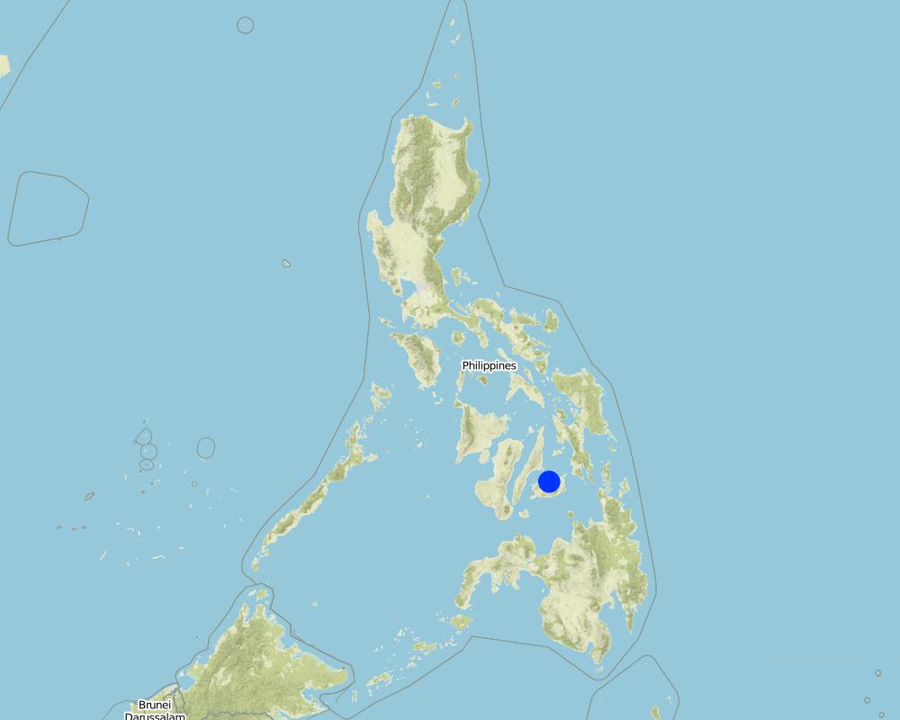
2.5 ประเทศภูมิภาค หรือสถานที่ตั้งที่เทคโนโลยีได้นำไปใช้และได้รับการครอบคลุมโดยการประเมินนี้
ประเทศ:
ฟิลิปปินส์
ภูมิภาค/รัฐ/จังหวัด:
Brgy. San Miguel
ข้อมูลจำเพาะเพิ่มเติมของสถานที่ตั้ง :
Danao, Bohol
ระบุการกระจายตัวของเทคโนโลยี:
- กระจายไปอย่างสม่ำเสมอในพื้นที่
If the Technology is evenly spread over an area, specify area covered (in km2):
3.6
If precise area is not known, indicate approximate area covered:
- 1-10 ตร.กม.
แสดงความคิดเห็น:
Total area covered by the SLM Technology is 3.6 km2.
Map
×2.6 วันที่การดำเนินการ
ถ้าไม่รู้ปีที่แน่นอน ให้ระบุวันที่โดยประมาณ:
- มากกว่า 50 ปี (แบบดั้งเดิม)
2.7 คำแนะนำของเทคโนโลยี
- DENR (Department of Environment and Natural Resources) protocol on reforestration
3. การจัดประเภทของเทคโนโลยี SLM
3.2 ประเภทของการใช้ที่ดินในปัจจุบันที่ได้นำเทคโนโลยีไปใช้

ป่า/พื้นที่ทำไม้
- Tree regeneration
ผลิตภัณฑ์และบริการ:
- ผลไม้และถั่ว
- ผลิตภัณฑ์อื่น ๆ จากป่า
แสดงความคิดเห็น:
Major land use problems (compiler’s opinion): Forest fire, competition with weedy species
Major land use problems (land users’ perception): spread of invasive alien species
Other type of forest: tree regeneration
Problems / comments regarding forest use: Increase of biodiversity (Wildlife)
Forest products and services: fruits and nuts, other forest products / uses (honey, medical, etc.)
Number of growing seasons per year: 2
3.5 กลุ่ม SLM ที่ตรงกับเทคโนโลยีนี้
- การจัดการป่าธรรมชาติและกึ่งธรรมชาติ
- Firebreak
3.6 มาตรการ SLM ที่ประกอบกันเป็นเทคโนโลยี

มาตรการอนุรักษ์ด้วยวิธีพืช
- V3: กำจัดพืชออกให้หมด
- V5: อื่นๆ
แสดงความคิดเห็น:
Main measures: vegetative measures
Specification of other vegetative measures: Pruning of kakawate, root crop planting
Type of vegetative measures: aligned: -along boundary
3.7 รูปแบบหลักของการเสื่อมโทรมของที่ดินที่ได้รับการแก้ไขโดยเทคโนโลยี

การเสื่อมโทรมของดินทางด้านชีวภาพ
- Bc (Reduction of vegetation cover): การลดลงของจำนวนพืชที่ปกคลุมดิน
- Bh (Loss of habitat): การสูญเสียแหล่งที่อยู่
- Bf (Detrimenta leffects of fires): ผลเสียหายจากไฟ
แสดงความคิดเห็น:
Main type of degradation addressed: Bf: detrimental effects of fires
Secondary types of degradation addressed: Bc: reduction of vegetation cover, Bh: loss of habitats
Main causes of degradation: deforestation / removal of natural vegetation (incl. forest fires)
3.8 การป้องกัน การลดลง หรือการฟื้นฟูความเสื่อมโทรมของที่ดิน
ระบุเป้าหมายของเทคโนโลยีกับความเสื่อมโทรมของที่ดิน:
- ป้องกันความเสื่อมโทรมของที่ดิน
แสดงความคิดเห็น:
Main goals: prevention of land degradation
4. ข้อมูลจำเพาะด้านเทคนิค กิจกรรมการนำไปปฏิบัติใช้ ปัจจัยนำเข้า และค่าใช้จ่าย
4.1 แบบแปลนทางเทคนิคของเทคโนโลยี
ข้อมูลจำเพาะด้านเทคนิค (แบบแปลนทางเทคนิคของเทคโนโลยี):
Firelines established in the ANR site.
Location: Barangay San Miguel. Danao, Bohol
Date: June 10, 2015
Technical knowledge required for field staff / advisors: moderate
Technical knowledge required for land users: moderate
Main technical functions: control of fires, reduction of dry material (fuel for wildfires)
Secondary technical functions: stabilisation of soil (eg by tree roots against land slides), sediment retention / trapping, sediment harvesting, increase of biomass (quantity), perimeter dirt road
Aligned: -along boundary
Vegetative material: T : trees / shrubs
Vertical interval within rows / strips / blocks (m): 1.5
Width within rows / strips / blocks (m): 10
Trees/ shrubs species: Kakawate trees
ผู้เขียน:
Mr. Patricio A. Yambot, Bureau of Soils and Water Management
4.3 กิจกรรมเพื่อการจัดตั้ง
| กิจกรรม | Timing (season) | |
|---|---|---|
| 1. | clearing of cogon grass in the firelines | February |
| 2. | Planting of kakawate cuttings | on set of rainy season |
4.4 ค่าใช้จ่ายของปัจจัยนำเข้าที่จำเป็นสำหรับการจัดตั้ง
| ปัจจัยนำเข้า | หน่วย | ปริมาณ | ค่าใช้จ่ายต่อหน่วย | ค่าใช้จ่ายทั้งหมดต่อปัจจัยนำเข้า | %ของค่าใช้จ่ายที่ก่อให้เกิดขึ้นโดยผู้ใช้ที่ดิน | |
|---|---|---|---|---|---|---|
| แรงงาน | clearing of cogon grass in the firelines and Planting of kakawate cuttings | ha | 1.0 | 26.66 | 26.66 | 100.0 |
| ค่าใช้จ่ายทั้งหมดของการจัดตั้งเทคโนโลยี | 26.66 | |||||
| Total costs for establishment of the Technology in USD | 26.66 | |||||
แสดงความคิดเห็น:
Duration of establishment phase: 3 month(s)
4.5 การบำรุงรักษาสภาพหรือกิจกรรมที่เกิดขึ้นเป็นประจำ
| กิจกรรม | ช่วงระยะเวลา/ความถี่ | |
|---|---|---|
| 1. | brushing/clearing | Every after 4 months |
| 2. | Pruning of kakawate/per year | every 3 years |
4.6 ค่าใช้จ่ายของปัจจัยนำเข้าและกิจกรรมที่เกิดขึ้นเป็นประจำที่ต้องการการบำรุงรักษา (ต่อปี)
| ปัจจัยนำเข้า | หน่วย | ปริมาณ | ค่าใช้จ่ายต่อหน่วย | ค่าใช้จ่ายทั้งหมดต่อปัจจัยนำเข้า | %ของค่าใช้จ่ายที่ก่อให้เกิดขึ้นโดยผู้ใช้ที่ดิน | |
|---|---|---|---|---|---|---|
| แรงงาน | brushing/clearing as well as pruning of kakawate/per year | ha | 1.0 | 31.1 | 31.1 | 100.0 |
| ค่าใช้จ่ายทั้งหมดของการบำรุงรักษาสภาพเทคโนโลยี | 31.1 | |||||
| Total costs for maintenance of the Technology in USD | 31.1 | |||||
5. สิ่งแวดล้อมทางธรรมชาติและของมนุษย์
5.1 ภูมิอากาศ
ฝนประจำปี
- < 250 ม.ม.
- 251-500 ม.ม.
- 501-750 ม.ม.
- 751-1,000 ม.ม.
- 1,001-1,500 ม.ม.
- 1,501-2,000 ม.ม.
- 2,001-3,000 ม.ม.
- 3,001-4,000 ม.ม.
- > 4,000 ม.ม.
เขตภูมิอากาศเกษตร
- ชื้น
Thermal climate class: tropics
5.2 สภาพภูมิประเทศ
ค่าเฉลี่ยความลาดชัน:
- ราบเรียบ (0-2%)
- ลาดที่ไม่ชัน (3-5%)
- ปานกลาง (6-10%)
- เป็นลูกคลื่น (11-15%)
- เป็นเนิน (16-30%)
- ชัน (31-60%)
- ชันมาก (>60%)
ธรณีสัณฐาน:
- ที่ราบสูง/ที่ราบ
- สันเขา
- ไหล่เขา
- ไหล่เนินเขา
- ตีนเนิน
- หุบเขา
ระดับความสูง:
- 0-100 เมตร
- 101-500 เมตร
- 501-1,000 เมตร
- 1,001-1,500 เมตร
- 1,501-2,000 เมตร
- 2,001-2,500 เมตร
- 2,501-3,000 เมตร
- 3,001-4,000 เมตร
- > 4,000 เมตร
ความคิดเห็นและข้อมูลจำเพาะเพิ่มเติมเรื่องสภาพภูมิประเทศ:
Altitudinal zone: 101-500 m a.s.l. (220m)
5.3 ดิน
ค่าเฉลี่ยความลึกของดิน:
- ตื้นมาก (0-20 ซ.ม.)
- ตื้น (21-50 ซ.ม.)
- ลึกปานกลาง (51-80 ซ.ม.)
- ลึก (81-120 ซ.ม.)
- ลึกมาก (>120 ซ.ม.)
เนื้อดิน (ดินชั้นบน):
- ปานกลาง (ดินร่วน ทรายแป้ง)
อินทรียวัตถุในดิน:
- ปานกลาง (1-3%)
(ถ้ามี) ให้แนบคำอธิบายเรื่องดินแบบเต็มหรือระบุข้อมูลที่มีอยู่ เช่น ชนิดของดิน ค่า pH ของดินหรือความเป็นกรดของดิน ความสามารถในการแลกเปลี่ยนประจุบวก ไนโตรเจน ความเค็ม เป็นต้น:
Soil vertility is medium
Soil drainage/infiltration is medium
Soil water storage capacity is medium
5.4 ความเป็นประโยชน์และคุณภาพของน้ำ
ระดับน้ำใต้ดิน:
<5 เมตร
น้ำไหลบ่าที่ผิวดิน:
ปานกลาง
5.5 ความหลากหลายทางชีวภาพ
ความหลากหลายทางชนิดพันธุ์:
- สูง
5.6 ลักษณะของผู้ใช้ที่ดินที่นำเทคโนโลยีไปปฏิบัติใช้
แนวทางการตลาดของระบบการผลิต:
- เพื่อการยังชีพ (หาเลี้ยงตนเอง)
ระดับของความมั่งคั่งโดยเปรียบเทียบ:
- จน
เป็นรายบุคคล/ครัวเรือน:
- ลูกจ้าง (บริษัท รัฐบาล)
เพศ:
- หญิง
- ชาย
ระบุลักษณะอื่นๆที่เกี่ยวข้องของผู้ใช้ที่ดิน:
Land users applying the Technology are mainly common / average land users
Population density: 10-50 persons/km2
Annual population growth: 1% - 2%; 1%
100% of the land users are poor and own 100% of the land.
Market orientation of production system: Forest conservation and self subsistence ( Green breaks planted as cash crop )
5.7 Average area of land used by land users applying the Technology
- < 0.5 เฮกตาร์
- 0.5-1 เฮกตาร์
- 1-2 เฮกตาร์
- 2-5 เฮกตาร์
- 5-15 เฮกตาร์
- 15-50 เฮกตาร์
- 50-100 เฮกตาร์
- 100-500 เฮกตาร์
- 500-1,000 เฮกตาร์
- 1,000-10,000 เฮกตาร์
- >10,000 เฮกตาร์
พิจารณาว่าเป็นขนาดเล็ก กลาง หรือขนาดใหญ่ (ซึ่งอ้างอิงถึงบริบทระดับท้องถิ่น):
- ขนาดกลาง
แสดงความคิดเห็น:
Average: 75 ha
5.8 กรรมสิทธิ์ในที่ดิน สิทธิในการใช้ที่ดินและสิทธิในการใช้น้ำ
กรรมสิทธิ์ในที่ดิน:
- รัฐ
สิทธิในการใช้ที่ดิน:
- เข้าถึงได้แบบเปิด (ไม่ได้จัดระเบียบ)
5.9 การเข้าถึงบริการและโครงสร้างพื้นฐาน
สุขภาพ:
- จน
- ปานกลาง
- ดี
การศึกษา:
- จน
- ปานกลาง
- ดี
ความช่วยเหลือทางด้านเทคนิค:
- จน
- ปานกลาง
- ดี
การจ้างงาน (เช่น ภายนอกฟาร์ม):
- จน
- ปานกลาง
- ดี
ตลาด:
- จน
- ปานกลาง
- ดี
พลังงาน:
- จน
- ปานกลาง
- ดี
ถนนและการขนส่ง:
- จน
- ปานกลาง
- ดี
น้ำดื่มและการสุขาภิบาล:
- จน
- ปานกลาง
- ดี
6. ผลกระทบและสรุปคำบอกกล่าว
6.1 ผลกระทบในพื้นที่ดำเนินการ (On-site) จากการใช้เทคโนโลยี
ผลกระทบทางด้านเศรษฐกิจและสังคม
การผลิต
การผลิตพืชที่ใช้เลี้ยงปศุสัตว์
การผลิตไม้
รายได้และค่าใช้จ่าย
ภาระงาน
ผลกระทบด้านสังคมวัฒนธรรมอื่น ๆ
สถาบันของชุมชน
การบรรเทาความขัดแย้ง
Improved livelihoods and human well-being
แสดงความคิดเห็น/ระบุ:
Through the technology, People's Organization (PO) members were encouraged to plant cash crops as greenbreaks as an immediate source of food and additional income.
ผลกระทบด้านนิเวศวิทยา
วัฐจักรน้ำหรือน้ำบ่า
น้ำไหลบ่าที่ผิวดิน
ความหลากหลายทางชีวภาพของพืชและสัตว์
ความหลากหลายทางชีวภาพของพืช
ความหลากหลายของสัตว์
ลดความเสี่ยงของภัยพิบัติ
การปล่อยคาร์บอนและก๊าซเรือนกระจก
ความเสี่ยงจากไฟ
6.2 ผลกระทบนอกพื้นที่ดำเนินการ (Off-site) จากการใช้เทคโนโลยี
ความเสียหายต่อโครงสร้างพื้นฐานของรัฐหรือของเอกชน
6.3 การเผชิญและความตอบสนองของเทคโนโลยีต่อการเปลี่ยนแปลงสภาพภูมิอากาศที่ค่อยเป็นค่อยไป และสภาพรุนแรงของภูมิอากาศ / ภัยพิบัติ (ที่รับรู้ได้โดยผู้ใช้ที่ดิน)
การเปลี่ยนแปลงสภาพภูมิอากาศที่ค่อยเป็นค่อยไป
การเปลี่ยนแปลงสภาพภูมิอากาศที่ค่อยเป็นค่อยไป
| ฤดู | increase or decrease | เทคโนโลยีมีวิธีการรับมืออย่างไร | |
|---|---|---|---|
| อุณหภูมิประจำปี | เพิ่มขึ้น | ดี |
สภาพรุนแรงของภูมิอากาศ (ภัยพิบัติ)
ภัยพิบัติทางอุตุนิยมวิทยา
| เทคโนโลยีมีวิธีการรับมืออย่างไร | |
|---|---|
| พายุฝนประจำท้องถิ่น | ไม่ทราบ |
| พายุลมประจำท้องถิ่น | ไม่ทราบ |
ภัยพิบัติจากสภาพภูมิอากาศ
| เทคโนโลยีมีวิธีการรับมืออย่างไร | |
|---|---|
| ภัยจากฝนแล้ง | ดี |
ผลลัพธ์ตามมาที่เกี่ยวข้องกับภูมิอากาศอื่น ๆ
ผลลัพธ์ตามมาที่เกี่ยวข้องกับภูมิอากาศอื่น ๆ
| เทคโนโลยีมีวิธีการรับมืออย่างไร | |
|---|---|
| ช่วงการปลูกพืชที่ลดลงมา | ไม่ทราบ |
6.4 การวิเคราะห์ค่าใช้จ่ายและผลประโยชน์ที่ได้รับ
ผลประโยชน์ที่ได้รับเปรียบเทียบกับค่าใช้จ่ายในการจัดตั้งเป็นอย่างไร (จากมุมมองของผู้ใช้ที่ดิน)
ผลตอบแทนระยะสั้น:
ด้านลบเล็กน้อย
ผลตอบแทนระยะยาว:
ด้านบวก
ผลประโยชน์ที่ได้รับเปรียบเทียบกับค่าใช้จ่ายในการบำรุงรักษาหรือต้นทุนที่เกิดขึ้นซ้ำอีก เป็นอย่างไร (จากมุมมองของผู้ใช้ที่ดิน)
ผลตอบแทนระยะสั้น:
ด้านบวก
ผลตอบแทนระยะยาว:
ด้านบวก
6.5 การปรับตัวของเทคโนโลยี
- > 50%
Of all those who have adopted the Technology, how many did so spontaneously, i.e. without receiving any material incentives/ payments?
- 0-10%
แสดงความคิดเห็น:
100% of land user families have adopted the Technology with external material support
Comments on acceptance with external material support: The Department of Environment and Natural Resources (DENR) provided financial and technical support in the establishment of the technology.
Comments on spontaneous adoption: No spontaneous adoption was recorded without the support of the government (DENR) or private agencies.
6.7 จุดแข็ง / ข้อได้เปรียบ / โอกาสของเทคโนโลยี
| จุดแข็ง / ข้อได้เปรียบ / โอกาสในทัศนคติของผู้ใช้ที่ดิน |
|---|
|
The technology does not require heavy equipment and instrument during the establishment How can they be sustained / enhanced? Use of indigenous tools during establishment such as hoe and plows |
| จุดแข็ง / ข้อได้เปรียบ / โอกาสในทัศนคติของผู้รวบรวมหรือวิทยากรหลัก |
|---|
|
Relative small financial input in the establishment of the technology How can they be sustained / enhanced? Regular clearing of firebreaks |
6.8 จุดอ่อน / ข้อเสียเปรียบ / ความเสี่ยงของเทคโนโลยีและวิธีการแก้ไข
| จุดอ่อน / ข้อเสียเปรียบ / ความเสี่ยงในทัศนคติของผู้รวบรวมหรือวิทยากรหลัก | มีวิธีการแก้ไขได้อย่างไร |
|---|---|
| Fires could cross on the firebreaks because of big and overlapping canopies. | Regular trimming on the canopies of trees near the firelines and brushing of weeds/grasses. |
7. การอ้างอิงและการเชื่อมต่อ
7.1 วิธีการและแหล่งข้อมูล
ลิงก์และโมดูล
ขยายทั้งหมด ย่อทั้งหมดลิงก์
Assisted Natural Regeneration (ANR) [ฟิลิปปินส์]
A process of rehabilitating degraded forest lands by taking advantage of trees already growing in the area.
- ผู้รวบรวม: Philippine Overview of Conservation Approaches and Technologies
โมดูล
ไม่มีโมดูล