Drainage of coastal areas in north- western Germany [Germany]
- Creation:
- Update:
- Compiler: Martin Maier
- Editor: –
- Reviewers: Fabian Ottiger, David Streiff, Alexandra Gavilano
Tiefliegenden Küstenlandschaften mit künstlicher Entwässerung in Nordwestdeutschland
technologies_1714 - Germany
View sections
Expand all Collapse all1. General information
1.2 Contact details of resource persons and institutions involved in the assessment and documentation of the Technology
Key resource person(s)
SLM specialist:
Kleyer Michael
University of Oldenburg
Germany
SLM specialist:
Karrasch Leena
University of Oldenburg
Germany
SLM specialist:
Mayer Martin
University of Oldenburg
Germany
Name of project which facilitated the documentation/ evaluation of the Technology (if relevant)
Book project: Making sense of research for sustainable land management (GLUES)Name of project which facilitated the documentation/ evaluation of the Technology (if relevant)
Sustainable Coastal Land Management (COMTESS / GLUES)Name of the institution(s) which facilitated the documentation/ evaluation of the Technology (if relevant)
University of Oldenburg (University of Oldenburg) - Germany1.3 Conditions regarding the use of data documented through WOCAT
The compiler and key resource person(s) accept the conditions regarding the use of data documented through WOCAT:
Yes
2. Description of the SLM Technology
2.1 Short description of the Technology
Definition of the Technology:
Land reclaimed from the sea – ‘the coastal region in north-western Germany needs to be artificially drained, and this will be an increasing challenge with climate change.
2.2 Detailed description of the Technology
Description:
In some coastal locations of north-western Germany, during the 19th and 20th century, land was reclaimed from the sea: at present, the land lies below sea level. It is protected from the sea by a wall called ‘dyke’. The reason for reclamation by drainage and walls was to make use of the fertile soil for intensive cropland or pastures. In the Landkreis Aurich region, agriculture is the most important form of land use: it is the main source of income, supplemented by tourism.
Purpose of the Technology: However, in anticipation of the expected increase in winter precipitation due to climate change, extra freshwater discharge will need to be dealt with. Furthermore, the periods when natural discharge of freshwater into the sea can occur is likely to become shorter, due to the sea level rising – again as a result of climate change. Consequently, in autumn and winter, more freshwater will have to be pumped into the sea rather than being discharged naturally during low tides.
Establishment / maintenance activities and inputs: A dense drainage network enables intensive agriculture on the landward side of the primary sea wall. In total, one third of the Krummhörn community’s land is used for crops and one third as pasture. Drainage water from land which lies below sea level is pumped into the main drainage channels - which are at higher elevations and discharge naturally into the sea during low tides.
Natural / human environment: During storm tides when the sea level is high, large amounts of excess drainage water need to be pumped into the sea instead of naturally discharging. However, with climate change the present drainage network will no longer be capable of discharging all of the excess freshwater as a result of increased precipitation and sea level rise. This will require considerable investments in higher pumping capacities and an adapted drainage system with increased dimensions of ditches, as well as additional ditches in areas with a high flooding risk.
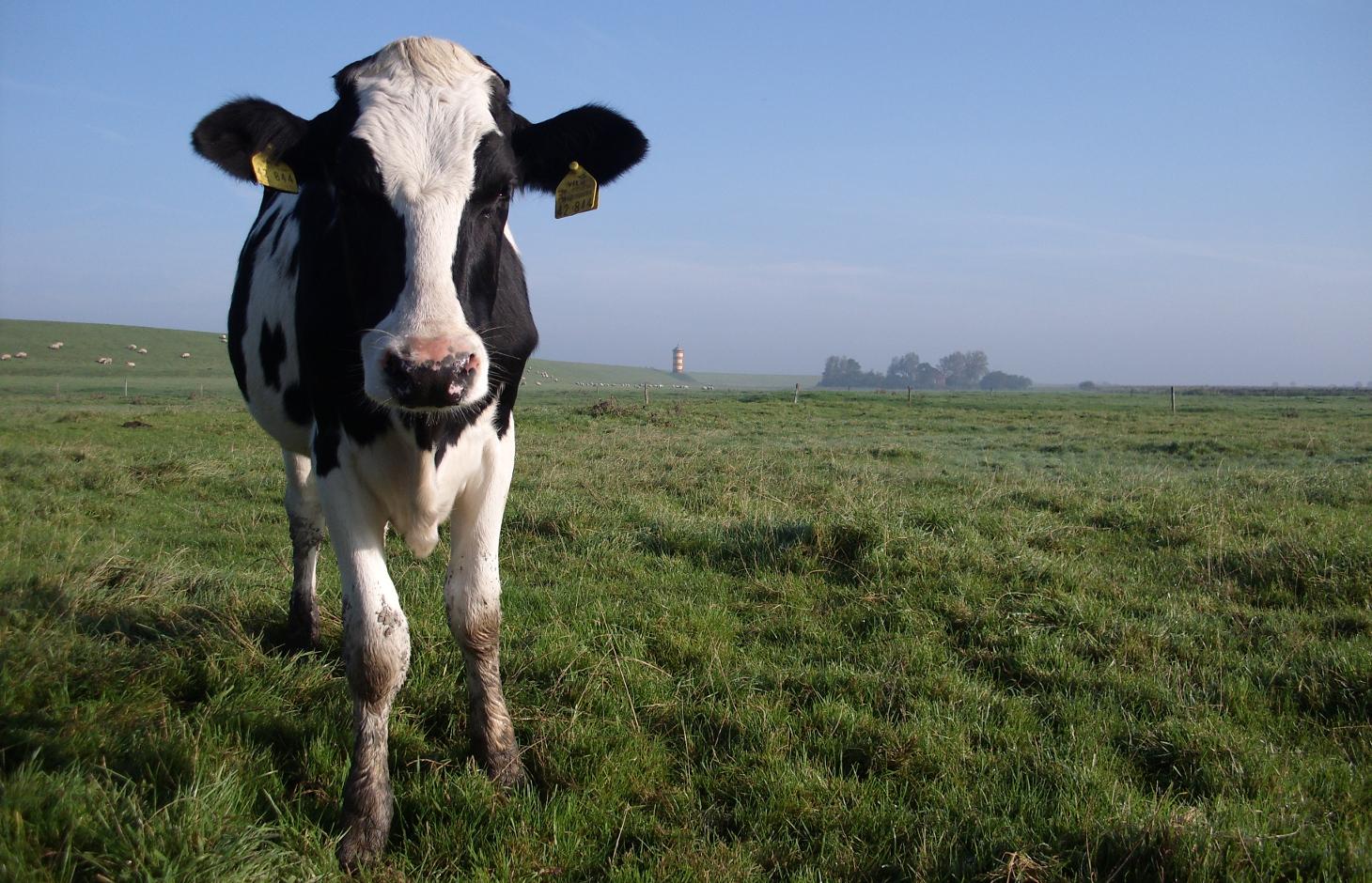
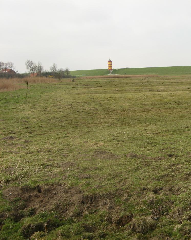
2.3 Photos of the Technology
Media Gallery
2.5 Country/ region/ locations where the Technology has been applied and which are covered by this assessment
Country:
Germany
Region/ State/ Province:
Germany, Lower Saxony
Further specification of location:
Landkreis Aurich
Comments:
Total area covered by the SLM Technology is 33.7 km2.
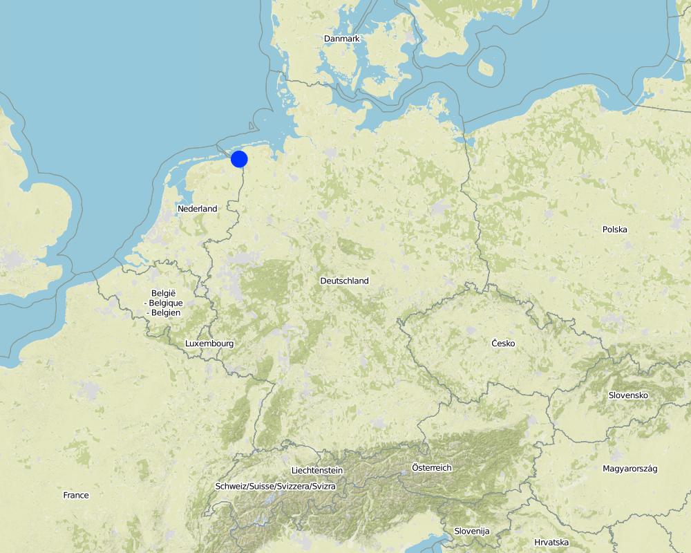
Map
×2.6 Date of implementation
If precise year is not known, indicate approximate date:
- more than 50 years ago (traditional)
2.7 Introduction of the Technology
Specify how the Technology was introduced:
- as part of a traditional system (> 50 years)
Comments (type of project, etc.):
Traditional land use with dense drainage network to enable intensive agricultural land use in low elevated coastal landscapes.
3. Classification of the SLM Technology
3.2 Current land use type(s) where the Technology is applied
Land use mixed within the same land unit:
Yes
Specify mixed land use (crops/ grazing/ trees):
- Agro-pastoralism (incl. integrated crop-livestock)

Cropland
- Annual cropping
Annual cropping - Specify crops:
- cereals - barley
- cereals - maize
- wheat
Number of growing seasons per year:
- 1
Specify:
Longest growing period in days: 240 Longest growing period from month to month: March to October

Grazing land
Intensive grazing/ fodder production:
- Cut-and-carry/ zero grazing
- Improved pastures
Animal type:
- cattle - dairy
- cattle - non-dairy beef
Products and services:
- meat
- milk
Comments:
Major land use problems (compiler’s opinion): Flood events and droughts may substantially disrupt the current land use system in the future and lead to higher drainage costs and higher economic risks for agricultural production. This will reduce the ecological and economic viability of the current intensive and highly productive land use under a changing climate.
Major land use problems (land users’ perception): There is no awareness of risks due to climate change.
Livestock density: > 100 LU /km2
3.3 Has land use changed due to the implementation of the Technology?
Has land use changed due to the implementation of the Technology?
- No (Continue with question 3.4)
Comments:
Mixed: Mp: Agro-pastoralism
3.4 Water supply
Water supply for the land on which the Technology is applied:
- mixed rainfed-irrigated
Comments:
Water supply: rainfed, mixed rainfed - irrigated
3.5 SLM group to which the Technology belongs
- water diversion and drainage
- surface water management (spring, river, lakes, sea)
3.6 SLM measures comprising the Technology

structural measures
- S3: Graded ditches, channels, waterways
Comments:
Main measures: structural measures
3.7 Main types of land degradation addressed by the Technology

water degradation
- Hg: change in groundwater/aquifer level
Comments:
Main type of degradation addressed: Hg: change in groundwater / aquifer level
Main causes of degradation: change of seasonal rainfall (Climate change, higher rainfall in winter, lower in summer), Heavy / extreme rainfall (intensity/amounts) (Heavy rainfall in winter due to climate change expected), floods (Flooding due to heavy rainfall in winter)
Secondary causes of degradation: droughts (Droughts due to less rainfall in summer (climate change))
4. Technical specifications, implementation activities, inputs, and costs
4.1 Technical drawing of the Technology
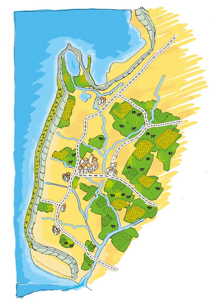
Technical specifications (related to technical drawing):
The figure shows the study region, located on the North Sea coast. The whole area is protected by a sea wall (grey). Crop fields (yellow), grasslands (green) and the drainage system (light blue) characterize the region. The traditional dense drainage network sometimes lacks the capacity to drain the lower land. This leads to flooding and limits agricultural productivity. It is expected that this flooding will increase with climate change. Agricultural production is faced with increased risks of crop failure in the future, unless the drainage system is strengthened.
Location: Krummhörn. County of Aurich, Lower Saxony
Technical knowledge required for land users: moderate
Main technical functions: decrease groundwater level by artificial drainage
Construction material (earth): digged in soil, no specific material needed
Author:
Udo Schotten
4.2 General information regarding the calculation of inputs and costs
other/ national currency (specify):
EURO
If relevant, indicate exchange rate from USD to local currency (e.g. 1 USD = 79.9 Brazilian Real): 1 USD =:
0.94
Indicate average wage cost of hired labour per day:
100.00
4.4 Costs and inputs needed for establishment
Comments:
Duration of establishment phase: 3 month(s)
4.5 Maintenance/ recurrent activities
| Activity | Timing/ frequency | |
|---|---|---|
| 1. | Maintenance of drainage system (ditches) | once per year |
4.6 Costs and inputs needed for maintenance/ recurrent activities (per year)
| Specify input | Unit | Quantity | Costs per Unit | Total costs per input | % of costs borne by land users | |
|---|---|---|---|---|---|---|
| Other | Maintenance cost pre km ditch | km ditch | 2270.7 |
4.7 Most important factors affecting the costs
Describe the most determinate factors affecting the costs:
Cost are affected by soil types and cost of labour. The calculation is based on the mean costs over many years. This gives a mean annual cost of Euro 2,270 per km ditch per year. With 1,145 km of ditches this totals Euro 2,600,000 per year for the whole area (approx. 49,000 ha).
5. Natural and human environment
5.1 Climate
Annual rainfall
- < 250 mm
- 251-500 mm
- 501-750 mm
- 751-1,000 mm
- 1,001-1,500 mm
- 1,501-2,000 mm
- 2,001-3,000 mm
- 3,001-4,000 mm
- > 4,000 mm
Agro-climatic zone
- humid
Thermal climate class: temperate
5.2 Topography
Slopes on average:
- flat (0-2%)
- gentle (3-5%)
- moderate (6-10%)
- rolling (11-15%)
- hilly (16-30%)
- steep (31-60%)
- very steep (>60%)
Landforms:
- plateau/plains
- ridges
- mountain slopes
- hill slopes
- footslopes
- valley floors
Altitudinal zone:
- 0-100 m a.s.l.
- 101-500 m a.s.l.
- 501-1,000 m a.s.l.
- 1,001-1,500 m a.s.l.
- 1,501-2,000 m a.s.l.
- 2,001-2,500 m a.s.l.
- 2,501-3,000 m a.s.l.
- 3,001-4,000 m a.s.l.
- > 4,000 m a.s.l.
5.3 Soils
Soil depth on average:
- very shallow (0-20 cm)
- shallow (21-50 cm)
- moderately deep (51-80 cm)
- deep (81-120 cm)
- very deep (> 120 cm)
Soil texture (topsoil):
- fine/ heavy (clay)
Topsoil organic matter:
- high (>3%)
If available, attach full soil description or specify the available information, e.g. soil type, soil PH/ acidity, Cation Exchange Capacity, nitrogen, salinity etc.
Soil fertility is high
Soil drainage/infiltration is medium
Soil water storage capacity is high
5.4 Water availability and quality
Ground water table:
< 5 m
Availability of surface water:
good
Water quality (untreated):
for agricultural use only (irrigation)
5.5 Biodiversity
Species diversity:
- low
5.6 Characteristics of land users applying the Technology
Market orientation of production system:
- commercial/ market
Off-farm income:
- 10-50% of all income
Relative level of wealth:
- average
Individuals or groups:
- employee (company, government)
Level of mechanization:
- mechanized/ motorized
Gender:
- women
- men
Indicate other relevant characteristics of the land users:
Land users applying the Technology are mainly common / average land users
Population density: 50-100 persons/km2
Annual population growth: < 0.5%
1% of the land users are very rich and own 1% of the land.
49% of the land users are rich and own 24% of the land.
50% of the land users are average wealthy and own 50% of the land.
and own 15% of the land.
Off-farm income specification: Many farmers do additional work in companies
5.7 Average area of land used by land users applying the Technology
- < 0.5 ha
- 0.5-1 ha
- 1-2 ha
- 2-5 ha
- 5-15 ha
- 15-50 ha
- 50-100 ha
- 100-500 ha
- 500-1,000 ha
- 1,000-10,000 ha
- > 10,000 ha
Is this considered small-, medium- or large-scale (referring to local context)?
- large-scale
Comments:
Average area of land owned or leased by land users applying the Technology: 5-15 ha, 15-50 ha, 50-100 ha, 100-500 ha
5.8 Land ownership, land use rights, and water use rights
Land ownership:
- individual, not titled
Land use rights:
- individual
5.9 Access to services and infrastructure
health:
- poor
- moderate
- good
education:
- poor
- moderate
- good
technical assistance:
- poor
- moderate
- good
employment (e.g. off-farm):
- poor
- moderate
- good
markets:
- poor
- moderate
- good
energy:
- poor
- moderate
- good
roads and transport:
- poor
- moderate
- good
drinking water and sanitation:
- poor
- moderate
- good
financial services:
- poor
- moderate
- good
6. Impacts and concluding statements
6.1 On-site impacts the Technology has shown
Socio-economic impacts
Production
crop production
fodder production
fodder quality
risk of production failure
production area
Water availability and quality
drinking water availability
irrigation water availability
Income and costs
farm income
Socio-cultural impacts
recreational opportunities
Ecological impacts
Water cycle/ runoff
water quantity
water quality
surface runoff
groundwater table/ aquifer
Soil
salinity
soil organic matter/ below ground C
Biodiversity: vegetation, animals
plant diversity
Comments/ specify:
Reduced crop diversity
habitat diversity
Comments/ specify:
Increased habitat fragmentation
6.2 Off-site impacts the Technology has shown
downstream flooding
damage on neighbours' fields
damage on public/ private infrastructure
Excess water
Hazard towards adverse events
6.3 Exposure and sensitivity of the Technology to gradual climate change and climate-related extremes/ disasters (as perceived by land users)
Gradual climate change
Gradual climate change
| Season | increase or decrease | How does the Technology cope with it? | |
|---|---|---|---|
| annual temperature | increase | well |
Climate-related extremes (disasters)
Meteorological disasters
| How does the Technology cope with it? | |
|---|---|
| local rainstorm | not well |
| local windstorm | not well |
Climatological disasters
| How does the Technology cope with it? | |
|---|---|
| drought | well |
Hydrological disasters
| How does the Technology cope with it? | |
|---|---|
| general (river) flood | not well |
Other climate-related consequences
Other climate-related consequences
| How does the Technology cope with it? | |
|---|---|
| reduced growing period | not known |
| climate change | not well |
6.4 Cost-benefit analysis
How do the benefits compare with the establishment costs (from land users’ perspective)?
Short-term returns:
very negative
Long-term returns:
positive
How do the benefits compare with the maintenance/ recurrent costs (from land users' perspective)?
Short-term returns:
positive
Long-term returns:
very positive
Comments:
Development of dense drainage network is very cost intensive but last for very long time. Maintainance cost are quite low compared to the benefits of intensive land use.
6.5 Adoption of the Technology
Of all those who have adopted the Technology, how many did so spontaneously, i.e. without receiving any material incentives/ payments?
- 91-100%
Comments:
100% of land user families have adopted the Technology without any external material support
Comments on spontaneous adoption: Well established technology in the whole region.
6.7 Strengths/ advantages/ opportunities of the Technology
| Strengths/ advantages/ opportunities in the land user’s view |
|---|
|
Optimal for agricultural production How can they be sustained / enhanced? Invest in infrastructure to maintain the system |
| Strengths/ advantages/ opportunities in the compiler’s or other key resource person’s view |
|---|
|
High agricultural production How can they be sustained / enhanced? Strengthen the drainage system to adapt to climate change |
6.8 Weaknesses/ disadvantages/ risks of the Technology and ways of overcoming them
| Weaknesses/ disadvantages/ risks in the compiler’s or other key resource person’s view | How can they be overcome? |
|---|---|
| High drainage costs | Development of water retention areas ( see A_GER001_en, A_GER002_en and A_GER003_en) |
| Landscape vulnerable to climate change | Development of water retention areas (see A_GER001_en, A_GER002_en and A_GER003_en) |
7. References and links
7.1 Methods/ sources of information
7.2 References to available publications
Title, author, year, ISBN:
http://www.comtess.uni-oldenburg.de/
7.3 Links to relevant online information
Title/ description:
http://www.comtess.uni-oldenburg.de/
Links and modules
Expand all Collapse allLinks
No links
Modules
No modules