In-field rain water harvesting [Lesotho]
- Creation:
- Update:
- Compiler: Matoka Moshoeshoe
- Editor: –
- Reviewers: Rima Mekdaschi Studer, William Critchley
Infiltration pits
technologies_4591 - Lesotho
View sections
Expand all Collapse all1. General information
1.2 Contact details of resource persons and institutions involved in the assessment and documentation of the Technology
SLM specialist:
Name of project which facilitated the documentation/ evaluation of the Technology (if relevant)
Decision Support for Mainstreaming and Scaling out Sustainable Land Management (GEF-FAO / DS-SLM)Name of the institution(s) which facilitated the documentation/ evaluation of the Technology (if relevant)
Integrated Catchment Management Project (Integrated Catchment Management Project) - Lesotho1.3 Conditions regarding the use of data documented through WOCAT
The compiler and key resource person(s) accept the conditions regarding the use of data documented through WOCAT:
Yes
1.4 Declaration on sustainability of the described Technology
Is the Technology described here problematic with regard to land degradation, so that it cannot be declared a sustainable land management technology?
No
Comments:
Its adoption is still at marginal scale since the Department has not yet introduced this technology in all ten(10) administrative districts in the country.
2. Description of the SLM Technology
2.1 Short description of the Technology
Definition of the Technology:
The infiltration pits are constructed on bare lands with the aim to enhance re-vegetation of plant species. The pits help to reduce soil erosion/land degradation as water is now able to infiltrate through the pits because they are constructed in succession. It also improves land productivity and cover as well as soil organic carbon.
2.2 Detailed description of the Technology
Description:
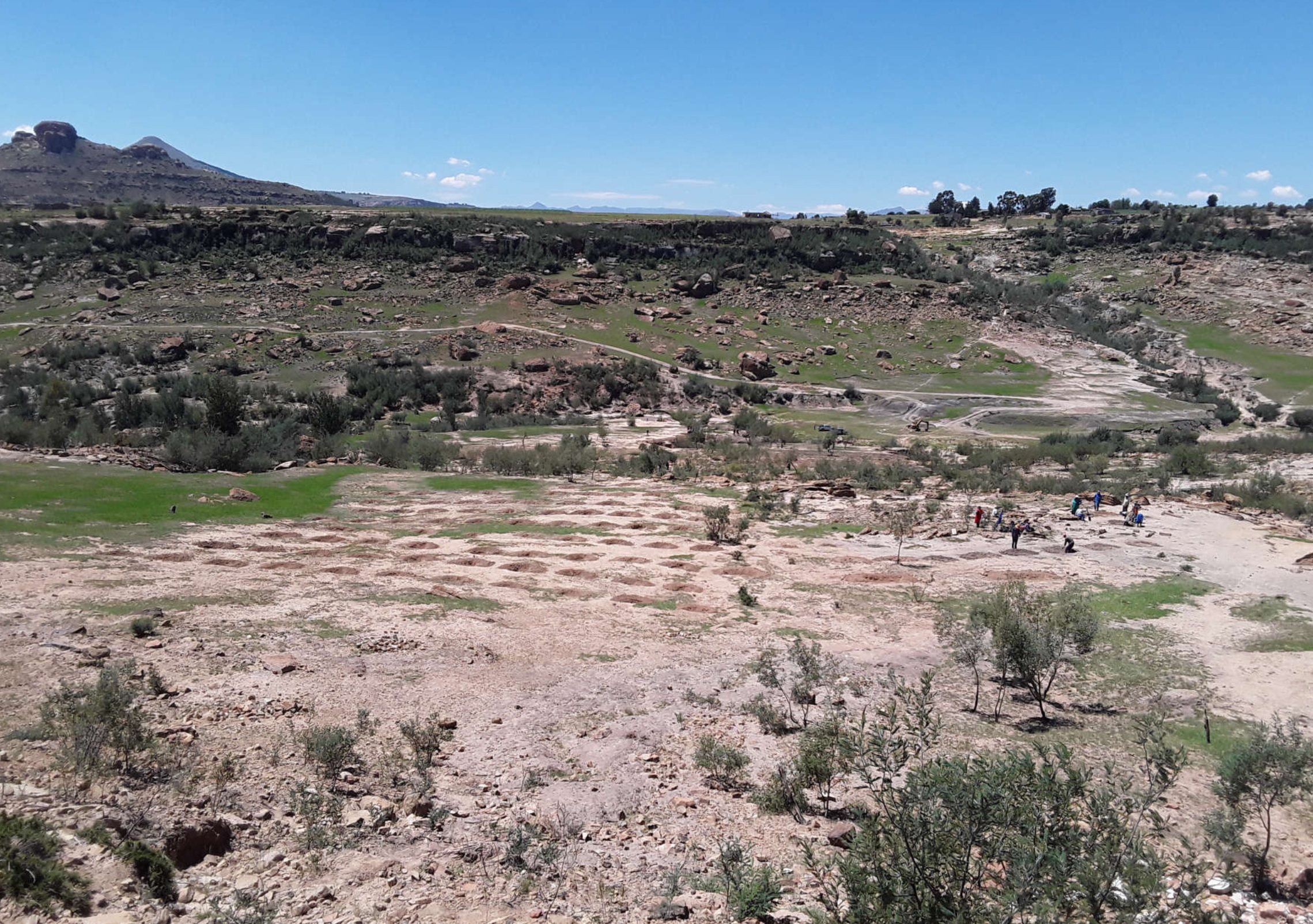
The technology is applied on natural marginal environment where the land is dry, they pits are mostly dug on the rangeland. The purpose is to harvest rain water/surface runoff consequently recharge soil moisture and support plant available water as highly as possible. After some time, there will be regeneration of vegetation. The dimensions of this structure may differ according to soil type, slope and rainfall intensity.
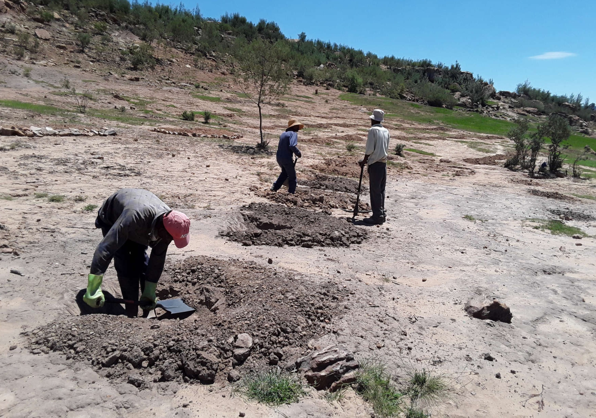
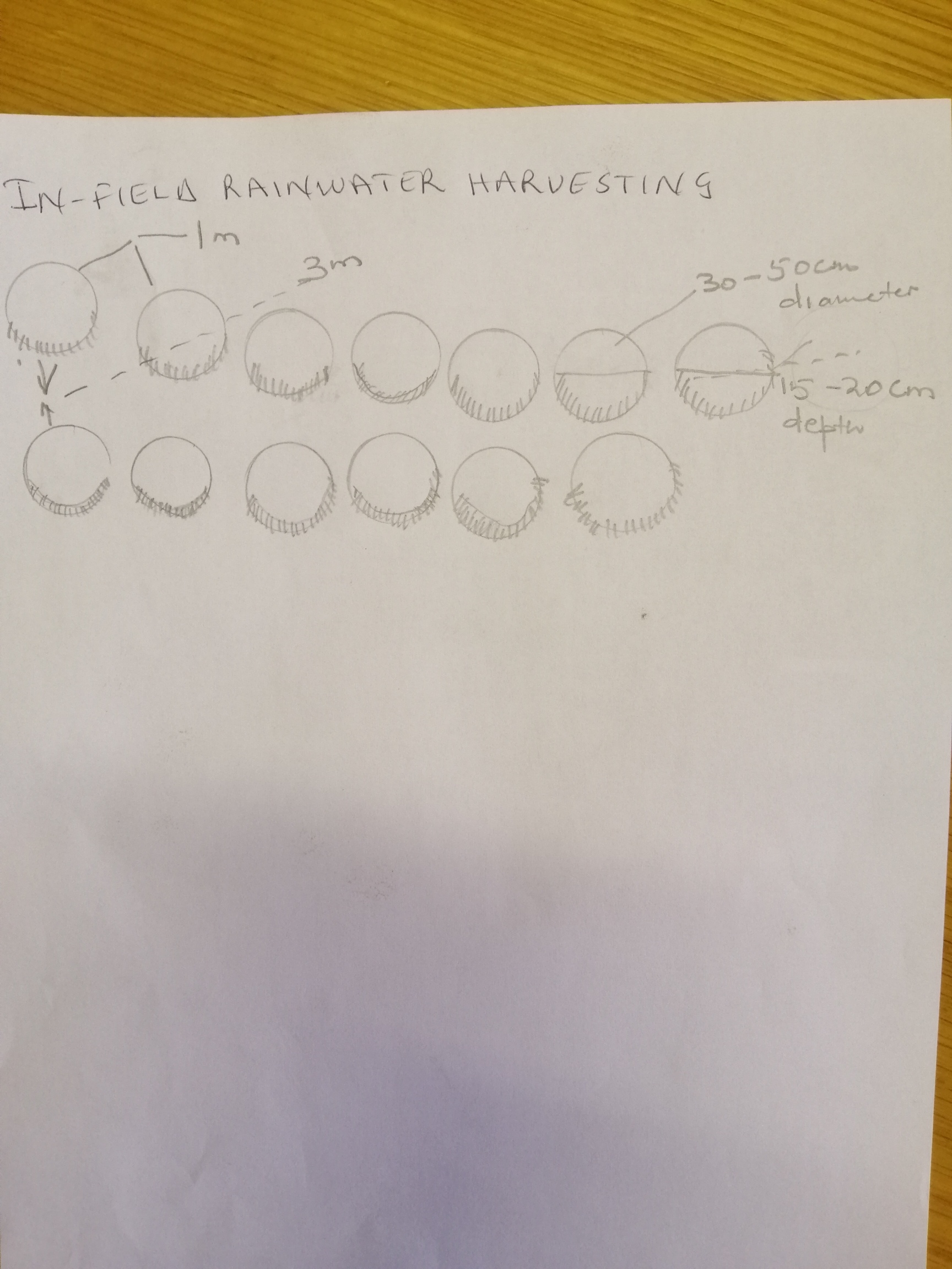
To construct this activity, the land should be bare or poor in plant biodiversity. Firstly, the extension workers hold public gatherings for a concerned community to make them aware of the land degradation in their area and possible solutions. In field rain water harvesting pits being one of them. The area is then surveyed using survey equipment (this is a technical survey not the one which uses questionnaires, this survey uses equipment such as theodolyte, auto cat etc). It is important to do the area survey because the technology follows the contour lines, otherwise it is likely to cause more harm on the land. The design of the technology is laid out by using the measuring tape, pick axe and spade. Construction starts from the top of field. Pits are dug in succession in a row following the contour with in row (intrarow) spacing of 1 m, pit depth of 20-30 cm and width of 1 m. Interrow spacing (between rows) is 3 m at 12% slope. After construction, kikuyu grass is sown around the pits to protect them from erosion. After the first storm, the area is then revisited for maintenance and repairs if need be. This technology is beneficial mostly in drylands where the water shortage is a major problem to improve land productivity. Although specififications are in this manner, this technology can be adapted differently in other areas depending on the amount of precipitation received by a certain area. For instance, some pits can be bigger or smaller than the given specifications.
The land users found it beneficial because the inputs needed to construct this technology are locally available such as spade, pick axe and grass for sodding. Furthermore, the rehabilitation benefits accrue within a short while. In addition, the technology is easy to construct. However, the land users found it tedious as they have to maintain it after every storm. The pits can be constructed on the rangeland and cropland which is no longer productive. in this era of climate change where this part of Southern Africa is becoming more dry everyday, this technology is even more applicable.
2.3 Photos of the Technology
Media Gallery

General remarks regarding photos:
higher resolution pictures could be requested
2.4 Videos of the Technology
Comments, short description:
N/A
Date:
26/03/2019
Location:
N/A
Name of videographer:
N/A
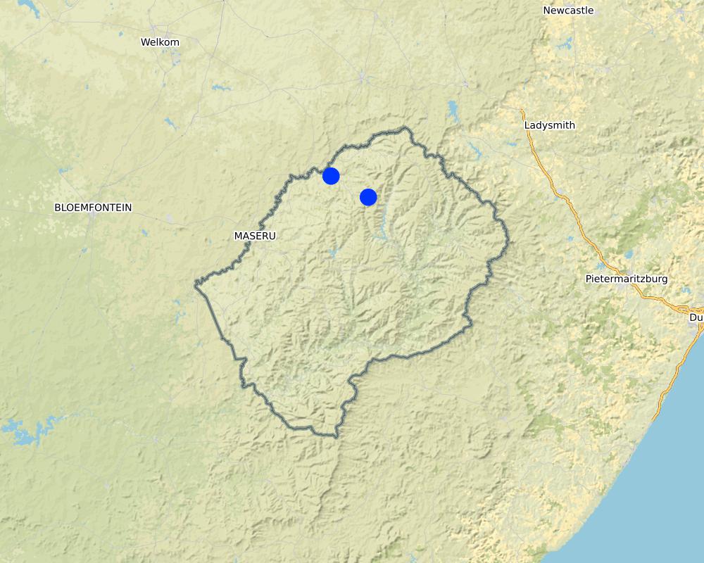
2.5 Country/ region/ locations where the Technology has been applied and which are covered by this assessment
Country:
Lesotho
Region/ State/ Province:
Leribe District
Further specification of location:
Peri-Urban
Specify the spread of the Technology:
- applied at specific points/ concentrated on a small area
Is/are the technology site(s) located in a permanently protected area?
No
Comments:
The activity is currently being scaled up/out in sub-catchments at sub-national level of which the areas are communally owned
Map
×2.6 Date of implementation
Indicate year of implementation:
2019
2.7 Introduction of the Technology
Specify how the Technology was introduced:
- through projects/ external interventions
Comments (type of project, etc.):
DS-SLM project pilot stage facilitated the adoption of the innovation
3. Classification of the SLM Technology
3.1 Main purpose(s) of the Technology
- improve production
- reduce, prevent, restore land degradation
- conserve ecosystem
- preserve/ improve biodiversity
- reduce risk of disasters
3.2 Current land use type(s) where the Technology is applied
Land use mixed within the same land unit:
Yes
Specify mixed land use (crops/ grazing/ trees):
- Silvo-pastoralism

Grazing land
Extensive grazing:
- Semi-nomadic pastoralism
- deferred grazing
Animal type:
- livestock - other small
Is integrated crop-livestock management practiced?
No
Products and services:
- transport/ draught
Species:
cattle - non-dairy beef
Count:
207
Species:
sheep
Count:
1307

Forest/ woodlands
- Tree plantation, afforestation
Tree plantation, afforestation: Specify origin and composition of species:
- Monoculture exotic variety
Type of tree plantation, afforestation:
- subtropical dry forest plantation
Type of tree:
- Acacia species
- Acacia dealbata
Are the trees specified above deciduous or evergreen?
- mixed deciduous/ evergreen
Products and services:
- Fuelwood

Settlements, infrastructure
- Settlements, buildings
Remarks:
settlement encroachment into range-lands
Comments:
Nearby waterways are natural and there are also seasonal streams full of fine sand which is currently mined. The mining of sand threatens stream banks thereby accelerating further erosion within the catchment boundaries. The sand mine is not directly where the SLM practices are practiced, but on the edge/boundaries and it will contribute to widening of gullies within this catchment in future.
3.3 Has land use changed due to the implementation of the Technology?
Has land use changed due to the implementation of the Technology?
- No (Continue with question 3.4)
3.4 Water supply
Water supply for the land on which the Technology is applied:
- rainfed
Comments:
The area is very dry
3.5 SLM group to which the Technology belongs
- natural and semi-natural forest management
- pastoralism and grazing land management
- water diversion and drainage
3.6 SLM measures comprising the Technology

agronomic measures
- A1: Vegetation/ soil cover
- A2: Organic matter/ soil fertility
- A6: Residue management

vegetative measures
- V2: Grasses and perennial herbaceous plants
- V4: Replacement or removal of alien/ invasive species

structural measures
- S3: Graded ditches, channels, waterways
- S4: Level ditches, pits

management measures
- M1: Change of land use type
- M2: Change of management/ intensity level
- M5: Control/ change of species composition
Comments:
This technology is practised on the rangeland, where the land is bare or has little vegetative cover. The aim of this technology is to collect as much rainwater as possible, to facilitate regeneration of vegetation so that ultimately the bare land/rangeland will have cover.
3.7 Main types of land degradation addressed by the Technology

soil erosion by water
- Wt: loss of topsoil/ surface erosion
- Wg: gully erosion/ gullying
- Wm: mass movements/ landslides
- Wr: riverbank erosion

chemical soil deterioration
- Cn: fertility decline and reduced organic matter content (not caused by erosion)
- Cs: salinization/ alkalinization

physical soil deterioration
- Pc: compaction
- Pk: slaking and crusting
- Pi: soil sealing
- Pw: waterlogging
- Pu: loss of bio-productive function due to other activities

biological degradation
- Bc: reduction of vegetation cover
- Bh: loss of habitats
- Bq: quantity/ biomass decline
- Bf: detrimental effects of fires
- Bs: quality and species composition/ diversity decline
- Bl: loss of soil life

water degradation
- Ha: aridification
- Hp: decline of surface water quality
Comments:
The technology addresses several types of land degradation when implemented properly.
3.8 Prevention, reduction, or restoration of land degradation
Specify the goal of the Technology with regard to land degradation:
- reduce land degradation
- restore/ rehabilitate severely degraded land
Comments:
Lesotho's landscape is continuously becoming bare owing to the impacts of land degradation, desertification and drought. This technology has been used effectively to counter the impacts of land degradation.
4. Technical specifications, implementation activities, inputs, and costs
4.1 Technical drawing of the Technology
Technical specifications (related to technical drawing):
Technical specifications:
Dimensions; height 20cm, depth 30cm, width 1m and length 1m
Spacing between structures; between rows 5m, between pits 3m
slope; 3-12%
construction material used; stones, soil, grass sodds , mulch and compost and grass seeds
6 litres is the water holding capacity of a pit
Author:
Matoka Moshoeshoe, Koetlisi Koetlisi and Mamofota Lekholoane
Date:
01/04/2015
4.2 General information regarding the calculation of inputs and costs
Specify how costs and inputs were calculated:
- per Technology area
Indicate size and area unit:
0.2 ha
If using a local area unit, indicate conversion factor to one hectare (e.g. 1 ha = 2.47 acres): 1 ha =:
N/A
Specify currency used for cost calculations:
- USD
Indicate average wage cost of hired labour per day:
4.6 US dollars
4.3 Establishment activities
| Activity | Timing (season) | |
|---|---|---|
| 1. | public awareness raising gathering | winter |
| 2. | survey of area/ terrain | winter |
| 3. | design and laying out of infiltration pits | winter |
| 4. | implementation/construction of pits | winter |
| 5. | sowing | winter and or summer |
| 6. | maintenance | when need arises |
Comments:
Due to impacts of climate change, the activity logistics could be done any-time as long as meteorological predictions allow
4.4 Costs and inputs needed for establishment
| Specify input | Unit | Quantity | Costs per Unit | Total costs per input | % of costs borne by land users | |
|---|---|---|---|---|---|---|
| Labour | one person | person-days | 1.0 | 5.0 | 5.0 | 5.0 |
| Equipment | pick axe | piece | 1.0 | 15.0 | 15.0 | |
| Equipment | spade | piece | 1.0 | 13.0 | 13.0 | |
| Equipment | measuring tape | piece | 1.0 | 8.0 | 8.0 | |
| Plant material | grass seed | kg | 2.0 | 13.0 | 26.0 | 25.0 |
| Construction material | stones | piece | 40.0 | 1.0 | 40.0 | |
| Total costs for establishment of the Technology | 107.0 | |||||
| Total costs for establishment of the Technology in USD | 107.0 | |||||
If land user bore less than 100% of costs, indicate who covered the remaining costs:
Government
Comments:
There are no costs incurred by land users bacause the rate of erosion is massive and highly costly therefore, farmers cannot afford to protect their own land without government intervention. The landowner simply contributes in-kind not in cash by maintaining that piece of land after rehabilitation.
4.5 Maintenance/ recurrent activities
| Activity | Timing/ frequency | |
|---|---|---|
| 1. | public gathering | after storm |
| 2. | re-survey | after storm |
| 3. | implementation | after storm |
Comments:
all maintenance works done after storm
4.6 Costs and inputs needed for maintenance/ recurrent activities (per year)
| Specify input | Unit | Quantity | Costs per Unit | Total costs per input | % of costs borne by land users | |
|---|---|---|---|---|---|---|
| Labour | grass seed | kg | 1.0 | 13.0 | 13.0 | |
| Labour | one person | person day | 1.0 | 5.0 | 5.0 | |
| Total costs for maintenance of the Technology | 18.0 | |||||
| Total costs for maintenance of the Technology in USD | 18.0 | |||||
If land user bore less than 100% of costs, indicate who covered the remaining costs:
Government
Comments:
maintenance is done by both community and government
4.7 Most important factors affecting the costs
Describe the most determinate factors affecting the costs:
Government annual budget affects inputs and labour
5. Natural and human environment
5.1 Climate
Annual rainfall
- < 250 mm
- 251-500 mm
- 501-750 mm
- 751-1,000 mm
- 1,001-1,500 mm
- 1,501-2,000 mm
- 2,001-3,000 mm
- 3,001-4,000 mm
- > 4,000 mm
Specify average annual rainfall (if known), in mm:
735.00
Specifications/ comments on rainfall:
The Northern parts of the country receive good amount of rainfall generally. This is the place where generally soils are also good and agricultural production is satisfactory so far.
Indicate the name of the reference meteorological station considered:
Hlotse
Agro-climatic zone
- semi-arid
The climate in this region favours agricultural production more than anything else. The Leribe district was once referred to as the bread basket of the country simply because the climate and soils are good for both crop and animal production.
5.2 Topography
Slopes on average:
- flat (0-2%)
- gentle (3-5%)
- moderate (6-10%)
- rolling (11-15%)
- hilly (16-30%)
- steep (31-60%)
- very steep (>60%)
Landforms:
- plateau/plains
- ridges
- mountain slopes
- hill slopes
- footslopes
- valley floors
Altitudinal zone:
- 0-100 m a.s.l.
- 101-500 m a.s.l.
- 501-1,000 m a.s.l.
- 1,001-1,500 m a.s.l.
- 1,501-2,000 m a.s.l.
- 2,001-2,500 m a.s.l.
- 2,501-3,000 m a.s.l.
- 3,001-4,000 m a.s.l.
- > 4,000 m a.s.l.
Indicate if the Technology is specifically applied in:
- not relevant
Comments and further specifications on topography:
The slope is moderate to gentle as the area extends towards the stream bank where there is depression. Above the area where the technology is implemented, there is a plateau where the community lives. However, the whole area is within a valley.
5.3 Soils
Soil depth on average:
- very shallow (0-20 cm)
- shallow (21-50 cm)
- moderately deep (51-80 cm)
- deep (81-120 cm)
- very deep (> 120 cm)
Soil texture (topsoil):
- coarse/ light (sandy)
Soil texture (> 20 cm below surface):
- medium (loamy, silty)
Topsoil organic matter:
- low (<1%)
If available, attach full soil description or specify the available information, e.g. soil type, soil PH/ acidity, Cation Exchange Capacity, nitrogen, salinity etc.
Soil type was not classified, a detailed soil type map of Lesotho can be found at https://lesis.gov.ls
5.4 Water availability and quality
Ground water table:
5-50 m
Availability of surface water:
medium
Water quality (untreated):
good drinking water
Water quality refers to:
both ground and surface water
Is water salinity a problem?
No
Is flooding of the area occurring?
No
Comments and further specifications on water quality and quantity:
There are natural springs which have have been developed by village water supply for community to access safe drinking water. There are seasonal streams around the area which communities use for washing and animal drinking.
5.5 Biodiversity
Species diversity:
- low
Habitat diversity:
- low
Comments and further specifications on biodiversity:
The area is mainly used as a range-land which is not given time to rest. Re-vegetation occurs very slowly due to mismanagement of the land.
5.6 Characteristics of land users applying the Technology
Sedentary or nomadic:
- Semi-nomadic
Market orientation of production system:
- subsistence (self-supply)
Off-farm income:
- less than 10% of all income
Relative level of wealth:
- average
Individuals or groups:
- individual/ household
- groups/ community
Level of mechanization:
- manual work
- animal traction
Gender:
- women
- men
Age of land users:
- middle-aged
- elderly
Indicate other relevant characteristics of the land users:
The land is used mainly for crop and animal production although there are signs of settlement encroachment.
5.7 Average area of land used by land users applying the Technology
- < 0.5 ha
- 0.5-1 ha
- 1-2 ha
- 2-5 ha
- 5-15 ha
- 15-50 ha
- 50-100 ha
- 100-500 ha
- 500-1,000 ha
- 1,000-10,000 ha
- > 10,000 ha
Is this considered small-, medium- or large-scale (referring to local context)?
- small-scale
Comments:
The area was used as a demonstration site. The technology is yet to be up-scaled to other areas.
5.8 Land ownership, land use rights, and water use rights
Land ownership:
- communal/ village
- individual, titled
Land use rights:
- open access (unorganized)
- communal (organized)
Water use rights:
- open access (unorganized)
- communal (organized)
Are land use rights based on a traditional legal system?
Yes
Comments:
According to the Land Act of 2010, land in Lesotho is vested in the Basotho nation and is held in trust by the King.
5.9 Access to services and infrastructure
health:
- poor
- moderate
- good
education:
- poor
- moderate
- good
technical assistance:
- poor
- moderate
- good
employment (e.g. off-farm):
- poor
- moderate
- good
markets:
- poor
- moderate
- good
energy:
- poor
- moderate
- good
roads and transport:
- poor
- moderate
- good
drinking water and sanitation:
- poor
- moderate
- good
financial services:
- poor
- moderate
- good
Comments:
The area is found in the peri-urban zone which is near the major town of Hlotse. There are access roads and they are closer to markets.
6. Impacts and concluding statements
6.1 On-site impacts the Technology has shown
Socio-economic impacts
Production
fodder production
Quantity before SLM:
vegetation cover was poor
Quantity after SLM:
increased vegetation cover
Comments/ specify:
quantity increased after SLM
fodder quality
Quantity before SLM:
fodder quality was also poor
Quantity after SLM:
increased quality
Comments/ specify:
There is now fodder available for animals
land management
Quantity before SLM:
land was poorly managed
Quantity after SLM:
community members agreed to protect the land
Comments/ specify:
The pits constructed have contributed positively to increase in land cover, land productivity and soil organic carbon
Socio-cultural impacts
food security/ self-sufficiency
Quantity before SLM:
animals were too weak
Quantity after SLM:
the quality of stock improved
Comments/ specify:
The technology has contributed positively towards availability of fodder hence good animal production
recreational opportunities
Quantity before SLM:
biodiversity was lost
Quantity after SLM:
regeneration of biodiversity
Comments/ specify:
both birds and wild animals are now occupying the habitat, communities use rehabilitated areas as parks or picnic area, and people pay to access that part of the land. The revenue collected will then be used for other purposes that might help community such as fixing a broken water tap etc.
SLM/ land degradation knowledge
Quantity before SLM:
community members did not have knowledge of the technology
Quantity after SLM:
community members can now construct the pits on their own in their own land
Comments/ specify:
knowledge on land degradation now improved
Ecological impacts
Water cycle/ runoff
harvesting/ collection of water
Quantity before SLM:
water was not collected
Quantity after SLM:
surface run-off was now collected
Comments/ specify:
a lot of water is now collected through this technology and not lost like it used to be
surface runoff
Quantity before SLM:
surface runoff was not controlled
Quantity after SLM:
surface run-off was partly collected
Comments/ specify:
surface run-off now partly collected and soil erosion minimised
excess water drainage
Quantity before SLM:
poor surface drainage
Quantity after SLM:
infiltration improved drainage
Comments/ specify:
surface drainage was controlled to enhance infiltration
Soil
soil moisture
Quantity before SLM:
prolonged dry-moist dry
Quantity after SLM:
conditional moisture
Comments/ specify:
improved
soil cover
Quantity before SLM:
the land was bare
Quantity after SLM:
revegetation
Comments/ specify:
improved vegetation abundance
soil loss
Quantity before SLM:
sheet erosion
Quantity after SLM:
sheet erosion disrupted
Comments/ specify:
surface roughness improved
soil accumulation
Quantity before SLM:
much soil loss
Quantity after SLM:
sedimentation improved
Comments/ specify:
sediment is collected in ditches
Biodiversity: vegetation, animals
biomass/ above ground C
Quantity before SLM:
bare ground
Quantity after SLM:
above ground biomass improved
Comments/ specify:
improved soil moisture supports biomass production
plant diversity
Quantity before SLM:
few species
Quantity after SLM:
species variety
Comments/ specify:
various species require availed prolonged soil moisture
Specify assessment of on-site impacts (measurements):
general biodiversity improved
6.2 Off-site impacts the Technology has shown
impact of greenhouse gases
Quantity before SLM:
less carbon stored in the soil
Quantity after SLM:
improved carbon sequestration
Comments/ specify:
soil organic carbon improved
Specify assessment of off-site impacts (measurements):
the activity is likely to be up-scaled
6.3 Exposure and sensitivity of the Technology to gradual climate change and climate-related extremes/ disasters (as perceived by land users)
Gradual climate change
Gradual climate change
| Season | increase or decrease | How does the Technology cope with it? | |
|---|---|---|---|
| annual temperature | increase | well | |
| seasonal rainfall | summer | increase | moderately |
Climate-related extremes (disasters)
Meteorological disasters
| How does the Technology cope with it? | |
|---|---|
| local thunderstorm | very well |
| local hailstorm | well |
Hydrological disasters
| How does the Technology cope with it? | |
|---|---|
| flash flood | well |
Comments:
The technology works very well when there is surface run-off as the main aim is to collect as much of run-off as possible for moisture retention.
6.4 Cost-benefit analysis
How do the benefits compare with the establishment costs (from land users’ perspective)?
Short-term returns:
neutral/ balanced
Long-term returns:
positive
How do the benefits compare with the maintenance/ recurrent costs (from land users' perspective)?
Short-term returns:
slightly negative
Long-term returns:
neutral/ balanced
Comments:
the technology can easily be maintained although maintenance plan does not exist
6.5 Adoption of the Technology
- 11-50%
If available, quantify (no. of households and/ or area covered):
sixty
Of all those who have adopted the Technology, how many did so spontaneously, i.e. without receiving any material incentives/ payments?
- 0-10%
Comments:
land users who own the land relative to those to those who have user rights only, saw the importance of the technology
6.6 Adaptation
Has the Technology been modified recently to adapt to changing conditions?
Yes
If yes, indicate to which changing conditions it was adapted:
- climatic change/ extremes
Specify adaptation of the Technology (design, material/ species, etc.):
the dimensions differ relative to the rainfall intensity, soil type and technician and land user preference
6.7 Strengths/ advantages/ opportunities of the Technology
| Strengths/ advantages/ opportunities in the land user’s view |
|---|
| the technology is implemented by both men and women |
| Middle-aged and elderly group were impressed with the technology |
| the technology uses locally available inputs |
| Strengths/ advantages/ opportunities in the compiler’s or other key resource person’s view |
|---|
| it is environmentally friendly |
| it helps in achieving variuos LDN targets |
| it can be demonstrated to a large group of people at once |
6.8 Weaknesses/ disadvantages/ risks of the Technology and ways of overcoming them
| Weaknesses/ disadvantages/ risks in the land user’s view | How can they be overcome? |
|---|---|
| they could be easily destroyed by single hailstorm | trenches be constructed to lower velocity and discharge of surface run-off |
| they could conditionally be filled with sediment | sediments should be removed periodically |
| Weaknesses/ disadvantages/ risks in the compiler’s or other key resource person’s view | How can they be overcome? |
|---|---|
| they could be easily destroyed by single hailstorm | trenches be constructed to lower velocity and discharge of surface run-off |
7. References and links
7.1 Methods/ sources of information
- field visits, field surveys
sixty
When were the data compiled (in the field)?
18/02/2019
Comments:
A public gathering/focus group discussion was held on site, community members were sensitised by extension workers from the Ministry of Forestry and its Line Ministries (Ministry of Agriculture, Ministry of Water, Ministry of Local Government) on the importance of the technology. Demonstrations were held after the public was informed about the importance of the technology.
7.2 References to available publications
Title, author, year, ISBN:
In-field rainwater harvesting: Conservation of your natural resources through in-field rainwater harvesting, Jacobus Botha, [2012]
Available from where? Costs?
Agricultureal Research Council, Institute for Soil, Climate and Water (ARC-SCW), South Africa
7.3 Links to relevant online information
Title/ description:
Agricultural Research Council, South Africa
URL:
www.arc.agric.za
7.4 General comments
other information regarding this technology was deduced from the report from Larry C. Tennyson, 2012
Links and modules
Expand all Collapse allLinks
No links
Modules
No modules