Ackerbau Fruchtfolge auf anmoorigem Boden [Switzerland]
- Creation:
- Update:
- Compiler: Julian Meier
- Editor: Aline Wicki
- Reviewers: Hanspeter Liniger, Rima Mekdaschi Studer
Ackerbau Fruchtfolge auf anmoorigem Boden
technologies_5838 - Switzerland
View sections
Expand all Collapse all1. General information
1.2 Contact details of resource persons and institutions involved in the assessment and documentation of the Technology
land user:
S. S.
Switzerland
1.3 Conditions regarding the use of data documented through WOCAT
The compiler and key resource person(s) accept the conditions regarding the use of data documented through WOCAT:
Yes
1.4 Declaration on sustainability of the described Technology
Is the Technology described here problematic with regard to land degradation, so that it cannot be declared a sustainable land management technology?
Yes
Comments:
Reduktion Organischer Substanz im Boden
Stauwasserproblematik aufgrund undurchlässiger Tonschicht im Unterboden
2. Description of the SLM Technology
2.1 Short description of the Technology
Definition of the Technology:
Ackerbaufruchtfolge auf anmoorigen Böden (>10% organische Substanz) mit Herausforderungen im Umgang mit Stauwasser aufgrund einer Wasserundurchlässigen Tonschicht im Unterboden.
2.2 Detailed description of the Technology
Description:
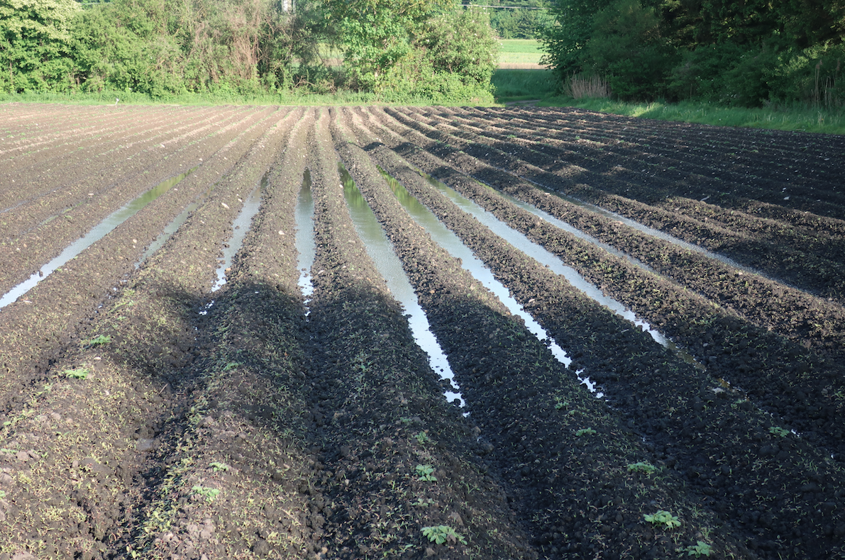
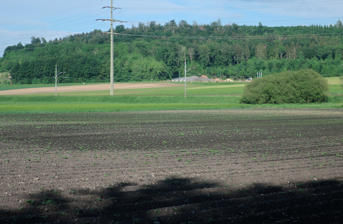
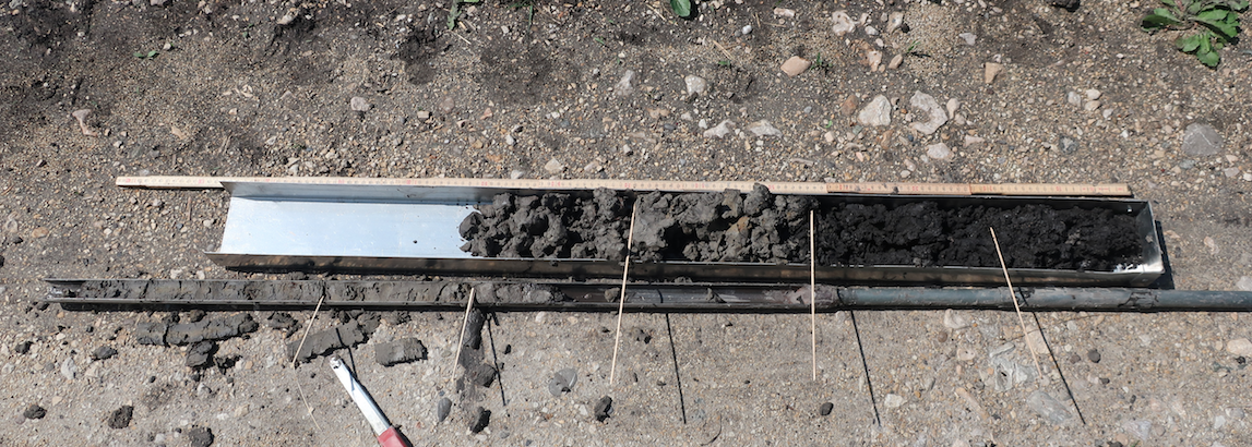
Der Landwirt bewirtschaftet in Kallnach verschiedene Felder in Pacht. Die beschriebene Parzelle umfasst ca. 1,9 Hektaren. Sie hat eine Länge von ungefähr 220 Metern und eine Breite von ungefähr 90 Metern. Der Oberboden (A-Horizont) ist unterschiedlich mächtig. Der organisch (>10%) nutzbare Oberboden variiert zwischen ca. 25 und 80 Zentimeter. Die Neigung über die Untersuchungsfläche ist nahezu null Grad. Es ist im Norden der Parzelle eine leicht konkave Struktur zu erkennen. In dieser Senke hat der Landwirt wiederholt mit derart Stauwasser zu kämpfen, dass er beträchtliche Ernteausfälle einbüsst.
Der Landwirt bepflanzt die Parzelle mit einer Zuckerrübe-Kartoffel-Getreide-Bohnen Fruchtfolge. Diese wird teilweise durch eine Gründüngung ergänzt. Sein Anbausystem ist geprägt durch die Drainage zur Entwässerung der Böden. Diese bewirken erst die Nutzung des Landes als Kulturland und sind daher essentiell für das Funktionieren des Systems. Trotzdem können sie die angesprochene Problematik in der Senke nicht vollends lösen.
Für die Bepflanzung der Kulturen verwendet der Landwirt verschiedene Maschinen. Der Boden wird regelmässig mit Pflug und Grubber bearbeitet.
Das zurzeit betriebene System wurde vom Landwirt selbst initiiert.
2.3 Photos of the Technology
Media Gallery
2.5 Country/ region/ locations where the Technology has been applied and which are covered by this assessment
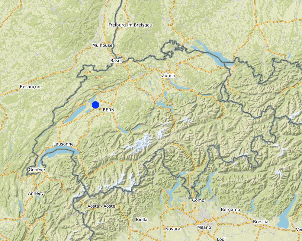
Country:
Switzerland
Region/ State/ Province:
Bern
Further specification of location:
Kallnach
Specify the spread of the Technology:
- evenly spread over an area
If the Technology is evenly spread over an area, specify area covered (in km2):
0.019
If precise area is not known, indicate approximate area covered:
- < 0.1 km2 (10 ha)
Is/are the technology site(s) located in a permanently protected area?
No
Map
×2.6 Date of implementation
If precise year is not known, indicate approximate date:
- 10-50 years ago
2.7 Introduction of the Technology
Specify how the Technology was introduced:
- through land users' innovation
- as part of a traditional system (> 50 years)
3. Classification of the SLM Technology
3.1 Main purpose(s) of the Technology
- improve production
- reduce, prevent, restore land degradation
- create beneficial economic impact
3.2 Current land use type(s) where the Technology is applied
Land use mixed within the same land unit:
No

Cropland
- Annual cropping
Annual cropping - Specify crops:
- cereals - barley
- cereals - maize
- legumes and pulses - beans
- root/tuber crops - potatoes
- root/tuber crops - sugar beet
Number of growing seasons per year:
- 1
Is intercropping practiced?
No
Is crop rotation practiced?
Yes
If yes, specify:
Der Landwirt hat zwischen 2015 und 2020 eine 4-Jährige Fruchtfolge von Zuckerrüben, Kartoffeln, Getreide und Bohnen angewendet.
3.3 Has land use changed due to the implementation of the Technology?
Has land use changed due to the implementation of the Technology?
- No (Continue with question 3.4)
3.4 Water supply
Water supply for the land on which the Technology is applied:
- mixed rainfed-irrigated
Comments:
Drainage System ist vorhanden
3.5 SLM group to which the Technology belongs
- rotational systems (crop rotation, fallows, shifting cultivation)
- irrigation management (incl. water supply, drainage)
- water diversion and drainage
3.6 SLM measures comprising the Technology

agronomic measures
- A1: Vegetation/ soil cover
- A3: Soil surface treatment
- A6: Residue management

structural measures
- S3: Graded ditches, channels, waterways
- S7: Water harvesting/ supply/ irrigation equipment

management measures
- M4: Major change in timing of activities
3.7 Main types of land degradation addressed by the Technology

soil erosion by wind
- Et: loss of topsoil

chemical soil deterioration
- Cn: fertility decline and reduced organic matter content (not caused by erosion)

physical soil deterioration
- Pc: compaction
- Pw: waterlogging
- Ps: subsidence of organic soils, settling of soil

other
Specify:
Stauwasser aufgrund der wasserstauenden Tonschicht im Unterboden
3.8 Prevention, reduction, or restoration of land degradation
Specify the goal of the Technology with regard to land degradation:
- reduce land degradation
4. Technical specifications, implementation activities, inputs, and costs
4.1 Technical drawing of the Technology
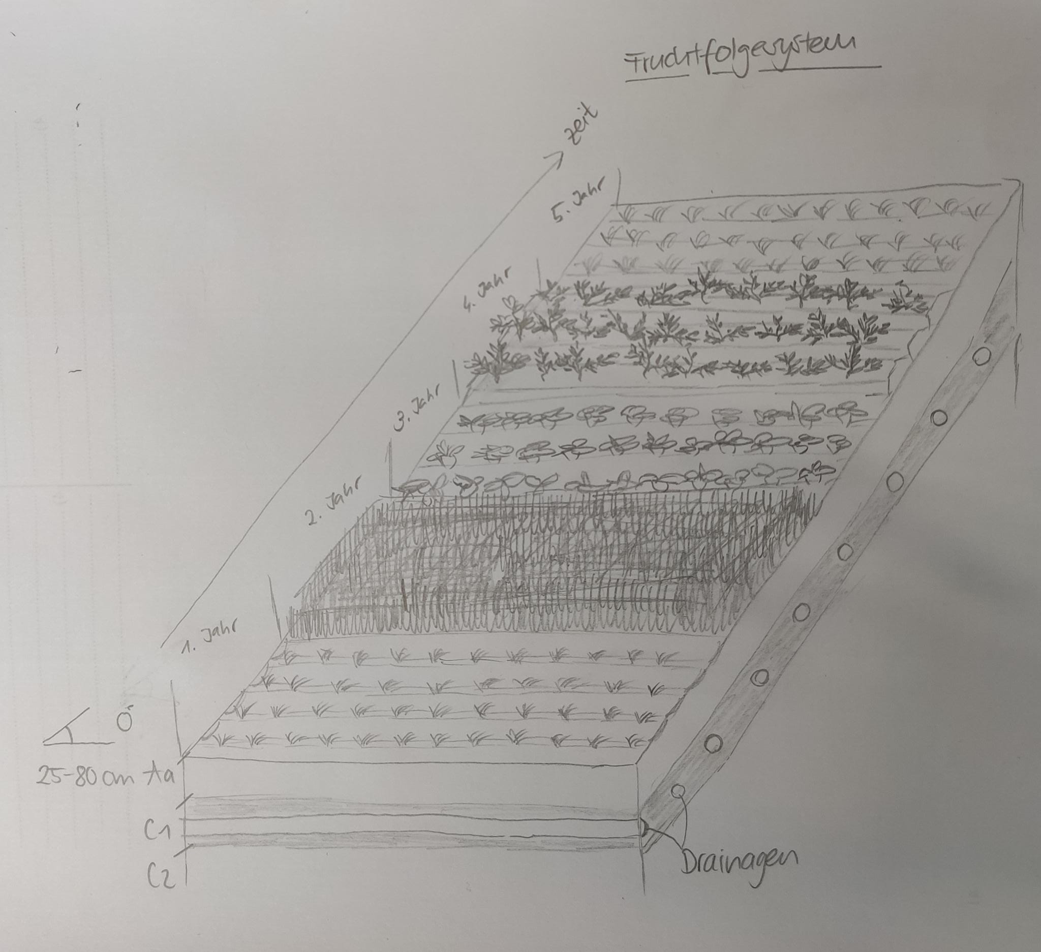
Technical specifications (related to technical drawing):
Ackerfläche: 1,9ha
Fruchtfolge: Zuckerrübe - Kartoffel - Getreie - Bohnen
Neigung: 0° (Schwachausgeprägte Senke im Norden der Parzelle entscheidend für Stauwasser)
Drainage: Ja
Bodenhorizontabfolge: A-C
A-Horizont: 25-80 cm / anmoorig (>10% organisches Substanz)
C-Horizont: tonige Stauschicht, mit zunehmender Tiefe mehr Schluff
Bodentyp: Buntgley
Author:
Aline Wicki / Julian Meier
Date:
30/10/2020
4.2 General information regarding the calculation of inputs and costs
Specify how costs and inputs were calculated:
- per Technology area
Indicate size and area unit:
1.9 Hektaren
other/ national currency (specify):
CHF
If relevant, indicate exchange rate from USD to local currency (e.g. 1 USD = 79.9 Brazilian Real): 1 USD =:
0.92
Indicate average wage cost of hired labour per day:
186
4.7 Most important factors affecting the costs
Describe the most determinate factors affecting the costs:
Es wurde für diesen Beschrieb keine Kostenrechnung vorgenommen, da ein Status-Quo beschrieben und keine Technologieveränderung vorgenommen wurde. Ausserdem lagen die Daten für die genaue Berechnung der Kosten für die Drainagen nicht vor.
5. Natural and human environment
5.1 Climate
Annual rainfall
- < 250 mm
- 251-500 mm
- 501-750 mm
- 751-1,000 mm
- 1,001-1,500 mm
- 1,501-2,000 mm
- 2,001-3,000 mm
- 3,001-4,000 mm
- > 4,000 mm
Specify average annual rainfall (if known), in mm:
957.00
Specifications/ comments on rainfall:
Keine Saisonalität. 12-18 Regentage pro Monat
Indicate the name of the reference meteorological station considered:
Messstation Fäschels
Agro-climatic zone
- sub-humid
Durchschnitt 7.4 Grad Celsius, Min. 2 Grad Celsius im Januar, Max. 23 Grad Celsius im Juni
5.2 Topography
Slopes on average:
- flat (0-2%)
- gentle (3-5%)
- moderate (6-10%)
- rolling (11-15%)
- hilly (16-30%)
- steep (31-60%)
- very steep (>60%)
Landforms:
- plateau/plains
- ridges
- mountain slopes
- hill slopes
- footslopes
- valley floors
Altitudinal zone:
- 0-100 m a.s.l.
- 101-500 m a.s.l.
- 501-1,000 m a.s.l.
- 1,001-1,500 m a.s.l.
- 1,501-2,000 m a.s.l.
- 2,001-2,500 m a.s.l.
- 2,501-3,000 m a.s.l.
- 3,001-4,000 m a.s.l.
- > 4,000 m a.s.l.
Indicate if the Technology is specifically applied in:
- concave situations
Comments and further specifications on topography:
Bei der Wasserstauenden Senke, sehr schwach ausgeprägt
5.3 Soils
Soil depth on average:
- very shallow (0-20 cm)
- shallow (21-50 cm)
- moderately deep (51-80 cm)
- deep (81-120 cm)
- very deep (> 120 cm)
Soil texture (topsoil):
- medium (loamy, silty)
Soil texture (> 20 cm below surface):
- medium (loamy, silty)
- fine/ heavy (clay)
Topsoil organic matter:
- high (>3%)
5.4 Water availability and quality
Ground water table:
< 5 m
Availability of surface water:
good
Water quality (untreated):
poor drinking water (treatment required)
Water quality refers to:
surface water
Is water salinity a problem?
No
Is flooding of the area occurring?
No
Comments and further specifications on water quality and quantity:
Viel Stauwasser nach Ereignissen mit mehr als 50 mm Niederschlag
5.5 Biodiversity
Species diversity:
- low
Habitat diversity:
- medium
5.6 Characteristics of land users applying the Technology
Sedentary or nomadic:
- Sedentary
Market orientation of production system:
- commercial/ market
Off-farm income:
- less than 10% of all income
Relative level of wealth:
- average
Individuals or groups:
- individual/ household
Level of mechanization:
- mechanized/ motorized
Gender:
- men
Age of land users:
- middle-aged
5.7 Average area of land used by land users applying the Technology
- < 0.5 ha
- 0.5-1 ha
- 1-2 ha
- 2-5 ha
- 5-15 ha
- 15-50 ha
- 50-100 ha
- 100-500 ha
- 500-1,000 ha
- 1,000-10,000 ha
- > 10,000 ha
Is this considered small-, medium- or large-scale (referring to local context)?
- medium-scale
Comments:
Durchschnitt Schweiz 20.5 ha (2019)
5.8 Land ownership, land use rights, and water use rights
Land ownership:
- communal/ village
- individual, titled
Land use rights:
- leased
- individual
Water use rights:
- communal (organized)
Are land use rights based on a traditional legal system?
Yes
Specify:
Schweizer Recht, Bundesverfassung Artikel 26 Eigentumsrecht
Burgergemeinde Kallnach
5.9 Access to services and infrastructure
health:
- poor
- moderate
- good
education:
- poor
- moderate
- good
technical assistance:
- poor
- moderate
- good
employment (e.g. off-farm):
- poor
- moderate
- good
markets:
- poor
- moderate
- good
energy:
- poor
- moderate
- good
roads and transport:
- poor
- moderate
- good
drinking water and sanitation:
- poor
- moderate
- good
financial services:
- poor
- moderate
- good
6. Impacts and concluding statements
6.1 On-site impacts the Technology has shown
Socio-economic impacts
Production
crop production
risk of production failure
product diversity
land management
Water availability and quality
irrigation water availability
demand for irrigation water
Income and costs
expenses on agricultural inputs
farm income
workload
Ecological impacts
Water cycle/ runoff
excess water drainage
evaporation
Soil
soil cover
soil loss
soil compaction
soil organic matter/ below ground C
Biodiversity: vegetation, animals
Vegetation cover
habitat diversity
pest/ disease control
Climate and disaster risk reduction
drought impacts
impacts of cyclones, rain storms
emission of carbon and greenhouse gases
wind velocity
Specify assessment of on-site impacts (measurements):
Wichtig: Da keine neuen Technologien in Rahmen dieses Projektes implementiert wurden, handelt es sich um einen Abgliech mit der durchschnittlichen Nutzung innerhalb eines 28,4 Hektaren grossen Perimeters in Kallnach BE. Die Einschätzungen erfolgten aufgrund von Beobachtungen im Feld, Bodenproben und Befragungen der Landwirte.
6.2 Off-site impacts the Technology has shown
water availability
groundwater/ river pollution
impact of greenhouse gases
Specify assessment of off-site impacts (measurements):
Wichtig: Da keine neuen Technologien in Rahmen dieses Projektes implementiert wurden, handelt es sich um einen Abgliech mit der durchschnittlichen Nutzung innerhalb eines 28,4 Hektaren grossen Perimeters in Kallnach BE. Die Einschätzungen erfolgten aufgrund von Beobachtungen im Feld, Bodenproben und Befragungen der Landwirte.
6.3 Exposure and sensitivity of the Technology to gradual climate change and climate-related extremes/ disasters (as perceived by land users)
Gradual climate change
Gradual climate change
| Season | increase or decrease | How does the Technology cope with it? | |
|---|---|---|---|
| annual temperature | increase | moderately | |
| seasonal temperature | winter | increase | well |
| seasonal temperature | spring | increase | well |
| seasonal temperature | summer | increase | moderately |
| seasonal temperature | autumn | increase | well |
Climate-related extremes (disasters)
Meteorological disasters
| How does the Technology cope with it? | |
|---|---|
| local rainstorm | not well |
Climatological disasters
| How does the Technology cope with it? | |
|---|---|
| heatwave | moderately |
| drought | moderately |
Other climate-related consequences
Other climate-related consequences
| How does the Technology cope with it? | |
|---|---|
| extended growing period | well |
6.4 Cost-benefit analysis
How do the benefits compare with the establishment costs (from land users’ perspective)?
Short-term returns:
negative
Long-term returns:
positive
How do the benefits compare with the maintenance/ recurrent costs (from land users' perspective)?
Short-term returns:
neutral/ balanced
Long-term returns:
neutral/ balanced
Comments:
Wichtig: Da keine neuen Technologien in Rahmen dieses Projektes implementiert wurden, handelt es sich um einen Abgliech mit der durchschnittlichen Nutzung innerhalb eines 28,4 Hektaren grossen Perimeters in Kallnach BE. Die Einschätzungen erfolgten aufgrund von Beobachtungen im Feld, Bodenproben und Befragungen der Landwirte.
6.5 Adoption of the Technology
- > 50%
Of all those who have adopted the Technology, how many did so spontaneously, i.e. without receiving any material incentives/ payments?
- 11-50%
6.6 Adaptation
Has the Technology been modified recently to adapt to changing conditions?
No
6.7 Strengths/ advantages/ opportunities of the Technology
| Strengths/ advantages/ opportunities in the land user’s view |
|---|
| Gute Böden zur Bewirtschaftung und gute Erträge |
| Strengths/ advantages/ opportunities in the compiler’s or other key resource person’s view |
|---|
| Gute Böden zur Bewirtschaftung und gute Erträge |
6.8 Weaknesses/ disadvantages/ risks of the Technology and ways of overcoming them
| Weaknesses/ disadvantages/ risks in the land user’s view | How can they be overcome? |
|---|---|
| Bewirtschaftung abhängig von Wetterextremen (Stauwasser) | Anpassung des Management (z.B. Zeitpunkt des Pflügens |
| Weaknesses/ disadvantages/ risks in the compiler’s or other key resource person’s view | How can they be overcome? |
|---|---|
| Ernteverlust bis zu 20 Aren aufgrund von Stauwasser nach Starkniederschlägen |
Bodenverbesserungsmassnahmen Adaption des Nutzungssystems |
7. References and links
7.1 Methods/ sources of information
- field visits, field surveys
Mehrere Feldbegehungen zwischen Mai und Oktober 2020
20 Bohrpunkte auf dem Perimeter (28.4 ha)
- interviews with land users
Befragung im Rahmen des Bodenverbesserungsprojekt Seeland (BOVE) und Masterarbeit
- compilation from reports and other existing documentation
Recherche
When were the data compiled (in the field)?
01/05/2020
Comments:
Mai bis Oktober 2020
7.2 References to available publications
Title, author, year, ISBN:
Wirz Set Handbücher, Agridea, 2020, ISBN: 978-3-7245-2369-7 (Handbuch Betrieb und Familie, Handbuch Pflanzen und Tiere)
Available from where? Costs?
44 CHF, Reinhard dt Verlag
7.3 Links to relevant online information
Title/ description:
Meteo Schweiz
URL:
https://www.meteoschweiz.admin.ch/home.html?tab=alarm
Title/ description:
Swisstopo
URL:
https://map.geo.admin.ch/?lang=de&topic=ech&bgLayer=ch.swisstopo.pixelkarte-farbe&layers=ch.swisstopo.zeitreihen,ch.bfs.gebaeude_wohnungs_register,ch.bav.haltestellen-oev,ch.swisstopo.swisstlm3d-wanderwege&layers_opacity=1,1,1,0.8&layers_visibility=false,false,false,false&layers_timestamp=18641231,,,&E=2583199.61&N=1207429.51&zoom=6.446143810225275
Links and modules
Expand all Collapse allLinks
No links
Modules
No modules