
Gemüse- und Ackerbau im auf organischen Böden [Switzerland]
- Creation:
- Update:
- Compiler: Julian Meier
- Editor: Aline Wicki
- Reviewers: Hanspeter Liniger, Rima Mekdaschi Studer
Gemüse- und Ackerbau
technologies_5844 - Switzerland
View sections
Expand all Collapse all1. General information
1.2 Contact details of resource persons and institutions involved in the assessment and documentation of the Technology
land user:
R. S.
Switzerland
1.3 Conditions regarding the use of data documented through WOCAT
The compiler and key resource person(s) accept the conditions regarding the use of data documented through WOCAT:
Yes
1.4 Declaration on sustainability of the described Technology
Is the Technology described here problematic with regard to land degradation, so that it cannot be declared a sustainable land management technology?
No
2. Description of the SLM Technology
2.1 Short description of the Technology
Definition of the Technology:
Der Landwirt praktiziert Gemüse- und Ackerbau auf organischen Böden im "Grossen Moos", dem ehemalig grössten Flachmoor der Schweiz. Dabei kultiviert er Gemüse wie Karotten und Zwiebeln, aber auch Ackerkutluren wie Mais, Kartoffeln und Winterweizen.
2.2 Detailed description of the Technology
Description:
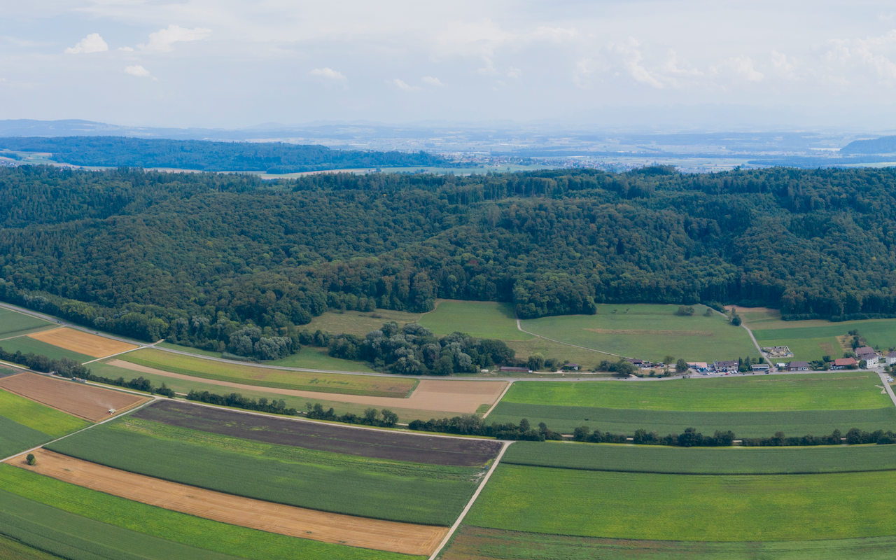
Der Landwirt R.S. bewirtschaftet im «Wideteile» in Gals Burgerland im Pachtvertrag auf organischen Böden im "Grossen Moos", dem ehemalig grössten Flachmoor der Schweiz. Die Familie hat keine Tiere. Auf der untersuchten Fläche wurden in den Jahren 2014-2020 Zwiebeln, Karotten, Mais, Winterweizen und Kartoffeln angebaut, beim Weizen UFA Lepha als Zwischengrün gesät. Der Boden ist geprägt durch den hohen Anteil an organischem Material, grösstenteils liegt der Anteil sogar über 30%, was ihn als Torf klassifizieren lässt. Im Perimeter Gals ist jedoch an einigen Stellen bereits die Seekreide an der Oberfläche. Die untersuchte Parzelle hingegen befindet sich in jenem Bereich des Perimeters, wo noch rund 75-105 Zentimeter Torf liegen. Der Torf eignet sich nach Aussagen des Landwirten gut für den Gemüsebau. Die Einheit ist weniger stark vernässt als andere Zonen im selben Perimeter und wirft gute Erträge ab. Der Betrieb ist gut mechanisiert. Der intensive Acker- und Gemüsebau hat zur Folge, dass bei jeder Kultur mehrere Überfahrten gemacht werden müssen. Die Flächen werden seit der ersten Juragwässerkorrektion (1868 bis 1891), welche das Gebiet grossflächig entwässert, bewirtschaftet. Zur Entwässerung sind Drainagen errichtet worden, welche die Nutzung dieser Flächen erst möglich machen.
Es handelt sich in diesem Beschrieb um jene Parzelle, welche auf dem Foto nicht vegetationsbedeckt ist
2.3 Photos of the Technology
Media Gallery
2.5 Country/ region/ locations where the Technology has been applied and which are covered by this assessment
Country:
Switzerland
Region/ State/ Province:
Bern
Further specification of location:
Gals BE
Specify the spread of the Technology:
- evenly spread over an area
If the Technology is evenly spread over an area, specify area covered (in km2):
0.0208
If precise area is not known, indicate approximate area covered:
- < 0.1 km2 (10 ha)
Is/are the technology site(s) located in a permanently protected area?
No
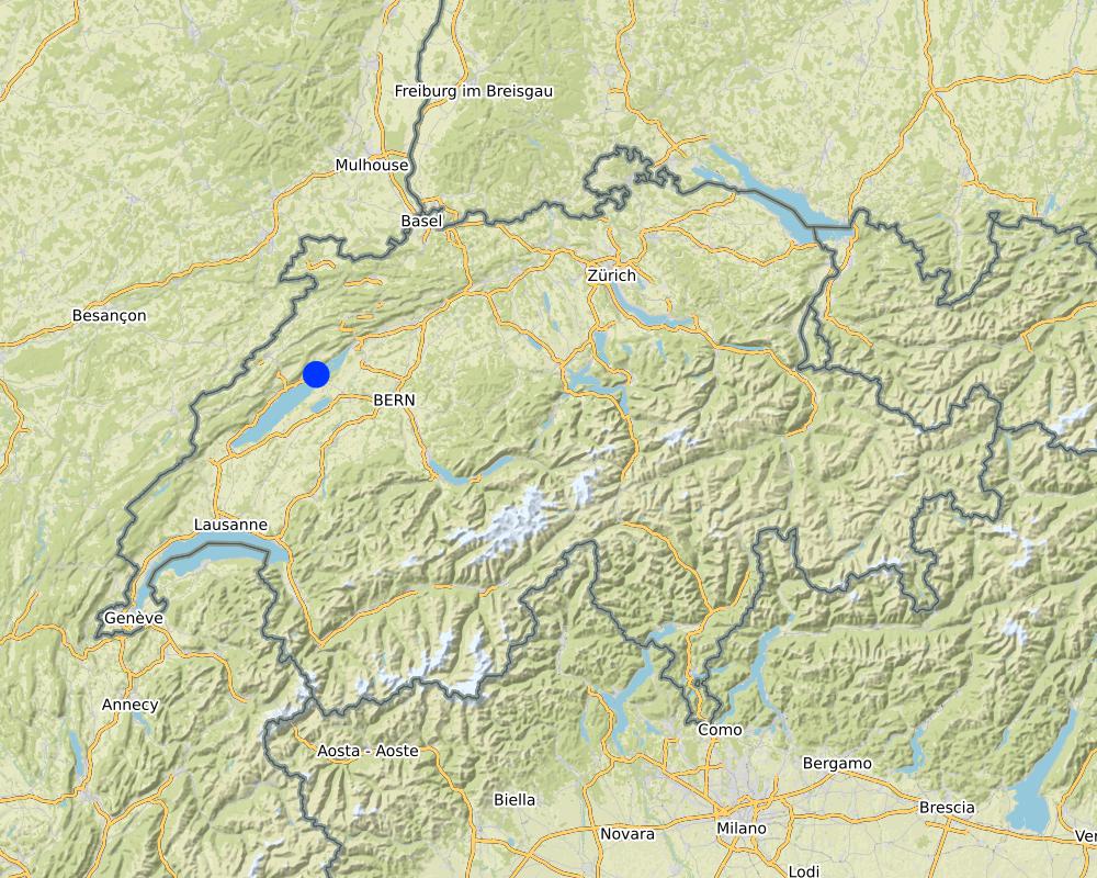
Map
×2.6 Date of implementation
If precise year is not known, indicate approximate date:
- more than 50 years ago (traditional)
2.7 Introduction of the Technology
Specify how the Technology was introduced:
- through land users' innovation
- as part of a traditional system (> 50 years)
3. Classification of the SLM Technology
3.1 Main purpose(s) of the Technology
- improve production
- create beneficial economic impact
3.2 Current land use type(s) where the Technology is applied
Land use mixed within the same land unit:
No

Cropland
- Annual cropping
Annual cropping - Specify crops:
- cereals - maize
- cereals - wheat (winter)
- root/tuber crops - potatoes
- vegetables - root vegetables (carrots, onions, beet, other)
Number of growing seasons per year:
- 1
Is intercropping practiced?
No
Is crop rotation practiced?
Yes
3.3 Has land use changed due to the implementation of the Technology?
Has land use changed due to the implementation of the Technology?
- No (Continue with question 3.4)
3.4 Water supply
Water supply for the land on which the Technology is applied:
- mixed rainfed-irrigated
3.5 SLM group to which the Technology belongs
- rotational systems (crop rotation, fallows, shifting cultivation)
- irrigation management (incl. water supply, drainage)
- water diversion and drainage
3.6 SLM measures comprising the Technology

agronomic measures
- A1: Vegetation/ soil cover
- A2: Organic matter/ soil fertility
- A3: Soil surface treatment
- A6: Residue management
A3: Differentiate tillage systems:
A 3.3: Full tillage (< 30% soil cover)
A6: Specify residue management:
A 6.3: collected

structural measures
- S3: Graded ditches, channels, waterways
- S7: Water harvesting/ supply/ irrigation equipment
3.7 Main types of land degradation addressed by the Technology

soil erosion by wind
- Et: loss of topsoil

chemical soil deterioration
- Cn: fertility decline and reduced organic matter content (not caused by erosion)

physical soil deterioration
- Pc: compaction
- Ps: subsidence of organic soils, settling of soil
4. Technical specifications, implementation activities, inputs, and costs
4.1 Technical drawing of the Technology
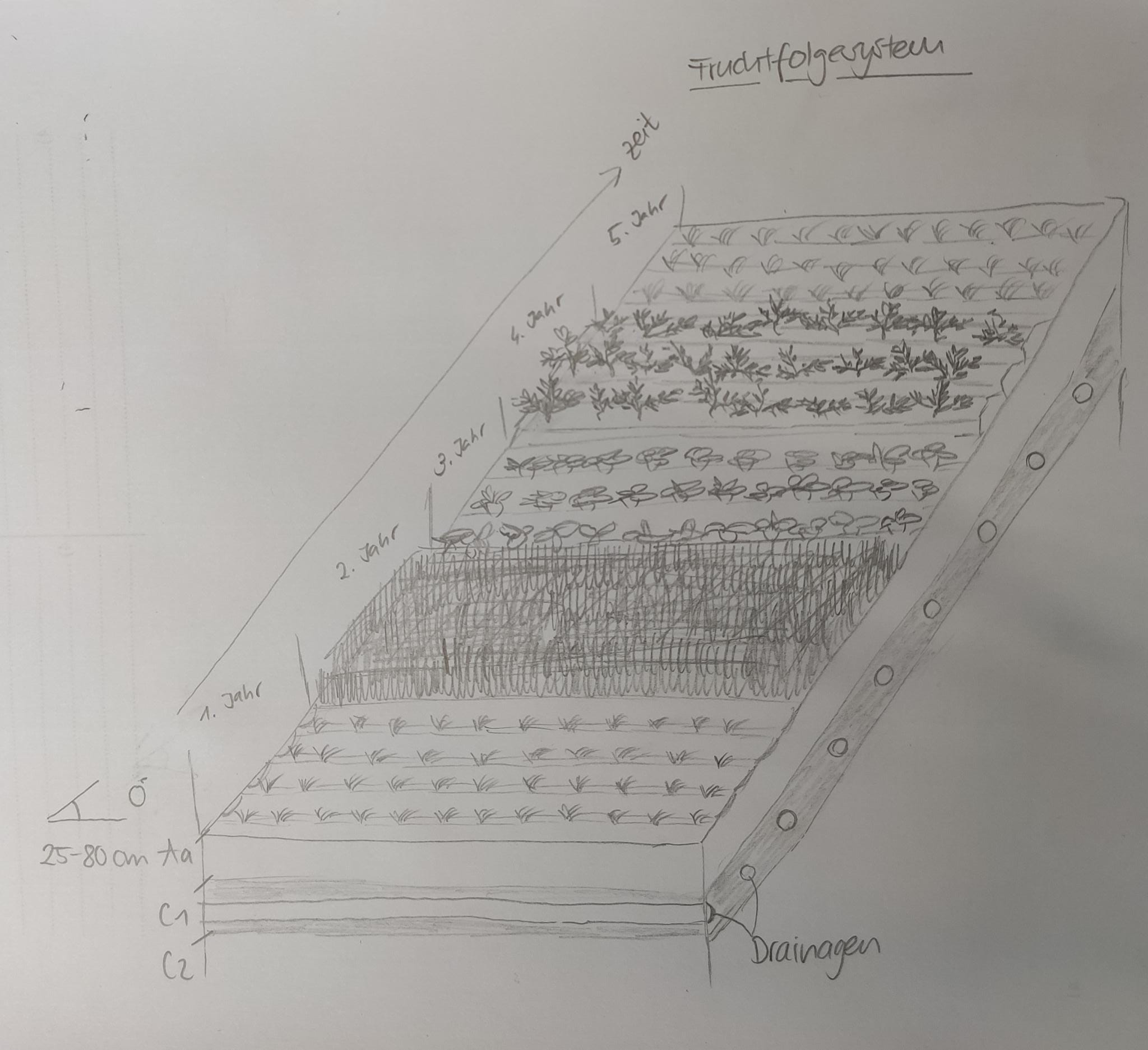
Technical specifications (related to technical drawing):
Fruchtfolge: Zwiebeln, Karotten, Mais, Winterweizen, Kartoffeln
Gründüngung: nach Winterweizen (Lepha)
Neigung: 0°
Drainage: Ja
Bodenhorizontabfolge: T-C
T-Horizont: bis zu 80 cm / Torf (>30% organisches Substanz)
C-Horizont: Seekreide
Bodentyp: Moorboden
Author:
Aline Wicki / Julian Meier
Date:
30/10/2020
4.2 General information regarding the calculation of inputs and costs
Specify how costs and inputs were calculated:
- per Technology area
Indicate size and area unit:
2.08 Hektaren
other/ national currency (specify):
CHF
If relevant, indicate exchange rate from USD to local currency (e.g. 1 USD = 79.9 Brazilian Real): 1 USD =:
0.92
Indicate average wage cost of hired labour per day:
186
4.7 Most important factors affecting the costs
Describe the most determinate factors affecting the costs:
Es wurde für diesen Beschrieb keine Kostenrechnung vorgenommen, da ein Status-Quo beschrieben und keine Technologieveränderung vorgenommen wurde. Ausserdem lagen die Daten für die genaue Berechnung der Kosten für die Drainagen nicht vor.
5. Natural and human environment
5.1 Climate
Annual rainfall
- < 250 mm
- 251-500 mm
- 501-750 mm
- 751-1,000 mm
- 1,001-1,500 mm
- 1,501-2,000 mm
- 2,001-3,000 mm
- 3,001-4,000 mm
- > 4,000 mm
Specify average annual rainfall (if known), in mm:
965.00
Specifications/ comments on rainfall:
Keine Saisonalität, 12 bis 18 Regentagen pro Monat
Indicate the name of the reference meteorological station considered:
Witzwil Meteo Schweiz, Messwert 2019
Agro-climatic zone
- sub-humid
Druchschnittlich 7.4 Grad Celsius; min. 2 Grad Celsius im Januar; max. 23 Grad Celsius im Juli
5.2 Topography
Slopes on average:
- flat (0-2%)
- gentle (3-5%)
- moderate (6-10%)
- rolling (11-15%)
- hilly (16-30%)
- steep (31-60%)
- very steep (>60%)
Landforms:
- plateau/plains
- ridges
- mountain slopes
- hill slopes
- footslopes
- valley floors
Altitudinal zone:
- 0-100 m a.s.l.
- 101-500 m a.s.l.
- 501-1,000 m a.s.l.
- 1,001-1,500 m a.s.l.
- 1,501-2,000 m a.s.l.
- 2,001-2,500 m a.s.l.
- 2,501-3,000 m a.s.l.
- 3,001-4,000 m a.s.l.
- > 4,000 m a.s.l.
Indicate if the Technology is specifically applied in:
- not relevant
5.3 Soils
Soil depth on average:
- very shallow (0-20 cm)
- shallow (21-50 cm)
- moderately deep (51-80 cm)
- deep (81-120 cm)
- very deep (> 120 cm)
Soil texture (topsoil):
- medium (loamy, silty)
Soil texture (> 20 cm below surface):
- medium (loamy, silty)
Topsoil organic matter:
- high (>3%)
5.4 Water availability and quality
Ground water table:
< 5 m
Availability of surface water:
good
Water quality (untreated):
poor drinking water (treatment required)
Water quality refers to:
surface water
Is water salinity a problem?
No
Is flooding of the area occurring?
No
5.5 Biodiversity
Species diversity:
- low
Habitat diversity:
- medium
5.6 Characteristics of land users applying the Technology
Sedentary or nomadic:
- Sedentary
Market orientation of production system:
- commercial/ market
Relative level of wealth:
- average
Individuals or groups:
- individual/ household
Level of mechanization:
- mechanized/ motorized
Gender:
- men
Age of land users:
- middle-aged
5.7 Average area of land used by land users applying the Technology
- < 0.5 ha
- 0.5-1 ha
- 1-2 ha
- 2-5 ha
- 5-15 ha
- 15-50 ha
- 50-100 ha
- 100-500 ha
- 500-1,000 ha
- 1,000-10,000 ha
- > 10,000 ha
Is this considered small-, medium- or large-scale (referring to local context)?
- medium-scale
Comments:
Schweizer Durchschnitt 20.5 Hektaren
5.8 Land ownership, land use rights, and water use rights
Land ownership:
- communal/ village
- individual, titled
- Flurpacht
Land use rights:
- leased
- individual
Water use rights:
- communal (organized)
Are land use rights based on a traditional legal system?
Yes
Specify:
BV Art. 26, Eigentumsrecht
5.9 Access to services and infrastructure
health:
- poor
- moderate
- good
education:
- poor
- moderate
- good
technical assistance:
- poor
- moderate
- good
employment (e.g. off-farm):
- poor
- moderate
- good
markets:
- poor
- moderate
- good
energy:
- poor
- moderate
- good
roads and transport:
- poor
- moderate
- good
drinking water and sanitation:
- poor
- moderate
- good
financial services:
- poor
- moderate
- good
6. Impacts and concluding statements
6.1 On-site impacts the Technology has shown
Socio-economic impacts
Production
crop production
fodder production
risk of production failure
product diversity
land management
Water availability and quality
irrigation water availability
demand for irrigation water
Income and costs
expenses on agricultural inputs
farm income
workload
Ecological impacts
Water cycle/ runoff
excess water drainage
evaporation
Soil
soil cover
soil loss
soil compaction
soil organic matter/ below ground C
Biodiversity: vegetation, animals
Vegetation cover
habitat diversity
pest/ disease control
Climate and disaster risk reduction
drought impacts
impacts of cyclones, rain storms
emission of carbon and greenhouse gases
wind velocity
Specify assessment of on-site impacts (measurements):
Wichtig: Da keine neuen Technologien in Rahmen dieses Projektes implementiert wurden, handelt es sich um einen Abgliech mit der durchschnittlichen Nutzung innerhalb eines 77,8 Hektaren grossen Perimeters in Gals BE. Die Einschätzungen erfolgten aufgrund von Beobachtungen im Feld, Bodenproben und Befragungen der Landwirte.
6.2 Off-site impacts the Technology has shown
water availability
groundwater/ river pollution
impact of greenhouse gases
Specify assessment of off-site impacts (measurements):
Wichtig: Da keine neuen Technologien in Rahmen dieses Projektes implementiert wurden, handelt es sich um einen Abgliech mit der durchschnittlichen Nutzung innerhalb eines 77,8 Hektaren grossen Perimeters in Gals BE. Die Einschätzungen erfolgten aufgrund von Beobachtungen im Feld, Bodenproben und Befragungen der Landwirte.
6.3 Exposure and sensitivity of the Technology to gradual climate change and climate-related extremes/ disasters (as perceived by land users)
Gradual climate change
Gradual climate change
| Season | increase or decrease | How does the Technology cope with it? | |
|---|---|---|---|
| annual temperature | increase | moderately | |
| seasonal temperature | winter | increase | well |
| seasonal temperature | spring | increase | well |
| seasonal temperature | summer | increase | moderately |
| seasonal temperature | autumn | increase | well |
Climate-related extremes (disasters)
Meteorological disasters
| How does the Technology cope with it? | |
|---|---|
| local rainstorm | moderately |
Climatological disasters
| How does the Technology cope with it? | |
|---|---|
| heatwave | moderately |
| drought | moderately |
Other climate-related consequences
Other climate-related consequences
| How does the Technology cope with it? | |
|---|---|
| extended growing period | well |
6.4 Cost-benefit analysis
How do the benefits compare with the establishment costs (from land users’ perspective)?
Short-term returns:
negative
Long-term returns:
very positive
How do the benefits compare with the maintenance/ recurrent costs (from land users' perspective)?
Short-term returns:
slightly positive
Long-term returns:
slightly positive
6.5 Adoption of the Technology
- > 50%
Of all those who have adopted the Technology, how many did so spontaneously, i.e. without receiving any material incentives/ payments?
- 11-50%
6.6 Adaptation
Has the Technology been modified recently to adapt to changing conditions?
No
6.7 Strengths/ advantages/ opportunities of the Technology
| Strengths/ advantages/ opportunities in the compiler’s or other key resource person’s view |
|---|
| Gute Böden für Gemüse- und Ackerbau Produktion, gute Erträge. |
6.8 Weaknesses/ disadvantages/ risks of the Technology and ways of overcoming them
| Weaknesses/ disadvantages/ risks in the compiler’s or other key resource person’s view | How can they be overcome? |
|---|---|
| Starke Ressourcenbelastung (Torfböden) | Weniger intensive Nutzung |
7. References and links
7.1 Methods/ sources of information
- field visits, field surveys
Feldbegehung im Sommer 2020
Daten aus dem BOVE-Projekt der HAFL, Sowohl Boden wie auch Nutzung
- interviews with land users
Ergänzende Informationen des Landwirten per Telefon im Dezember 2020
- compilation from reports and other existing documentation
Recherche
When were the data compiled (in the field)?
11/08/2020
7.2 References to available publications
Title, author, year, ISBN:
Wirz Set Handbücher, Agridea, 2020, ISBN: 978-3-7245-2369-7 (Handbuch Betrieb und Familie, Handbuch Pflanzen und Tiere)
Available from where? Costs?
44 CHF, Reinhard dt Verlag
7.3 Links to relevant online information
Title/ description:
Meteo Schweiz
URL:
https://www.meteoschweiz.admin.ch/home.html?tab=alarm
Title/ description:
Swisstopo
URL:
https://map.geo.admin.ch/?topic=ech&bgLayer=ch.swisstopo.pixelkarte-farbe&layers=ch.swisstopo.zeitreihen,ch.bfs.gebaeude_wohnungs_register,ch.bav.haltestellen-oev,ch.swisstopo.swisstlm3d-wanderwege&layers_opacity=1,1,1,0.8&layers_visibility=false,false,false,false&layers_timestamp=18641231,,,&lang=de&E=2570994.08&N=1209840.71&zoom=8.495381254669331
Links and modules
Expand all Collapse allLinks
No links
Modules
No modules