Establishment of intensive grazing areas on low productive slopes [希腊]
- 创建:
- 更新:
- 编制者: Costas Kosmas
- 编辑者: –
- 审查者: Ursula Gaemperli, Gudrun Schwilch
Βοσκότοπος
technologies_2900 - 希腊
查看章节
全部展开 全部收起1. 一般信息
1.2 参与该技术评估和文件编制的资源人员和机构的联系方式
关键资源人
土地使用者:
SLM专业人员:
有助于对技术进行记录/评估的项目名称(如相关)
Interactive Soil Quality assessment in Europe and China for Agricultural productivity and Environmental Resilience (EU-iSQAPER)有助于对技术进行记录/评估的机构名称(如相关)
Agricultural University of Athens (AUA) - 希腊1.3 关于使用通过WOCAT记录的数据的条件
(现场)数据是什么时候汇编的?:
14/09/2016
编制者和关键资源人员接受有关使用通过WOCAT记录数据的条件。:
是
1.4 所述技术的可持续性声明
这里所描述的技术在土地退化方面是否存在问题,导致无法被认为是一种可持续的土地管理技术?:
是
注释:
This technology favors soil erosion and land degradation for a short period (about one month) after sowing the plants.
2. SLM技术的说明
2.1 技术简介
技术定义:
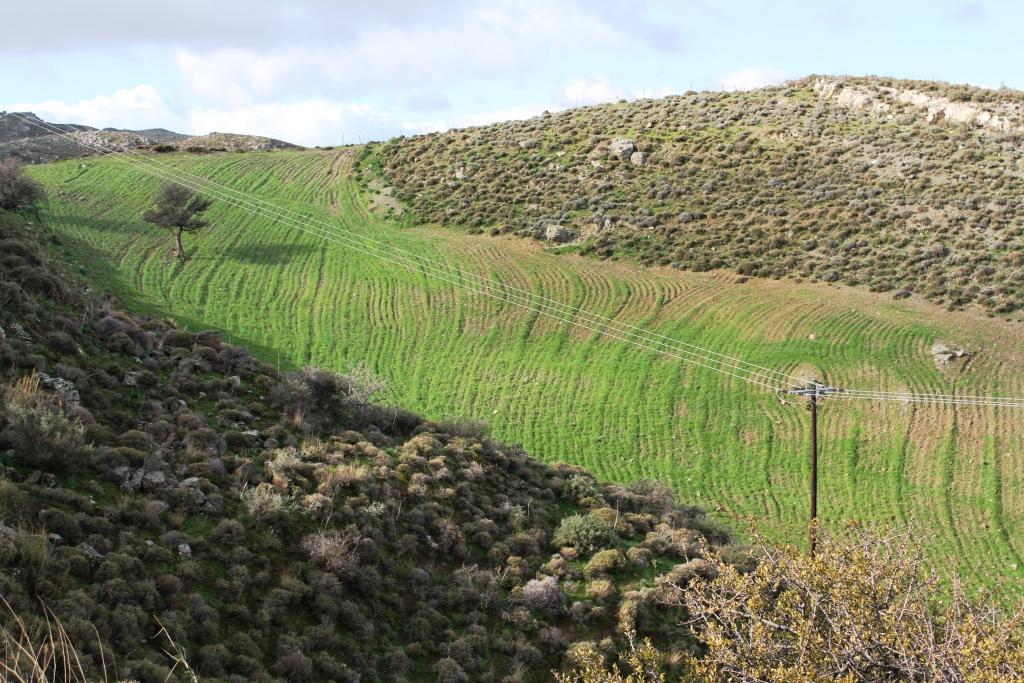
This technology consists of (a) ploughing the soil, (b) sowing the plants usually vetch or oat or in combination in November and (c) grazing the growing plants during spring. The main purpose of this technology is to increase the produced palatable biomass in a grazing land in which the biomass production is very low under natural conditions.
2.2 技术的详细说明
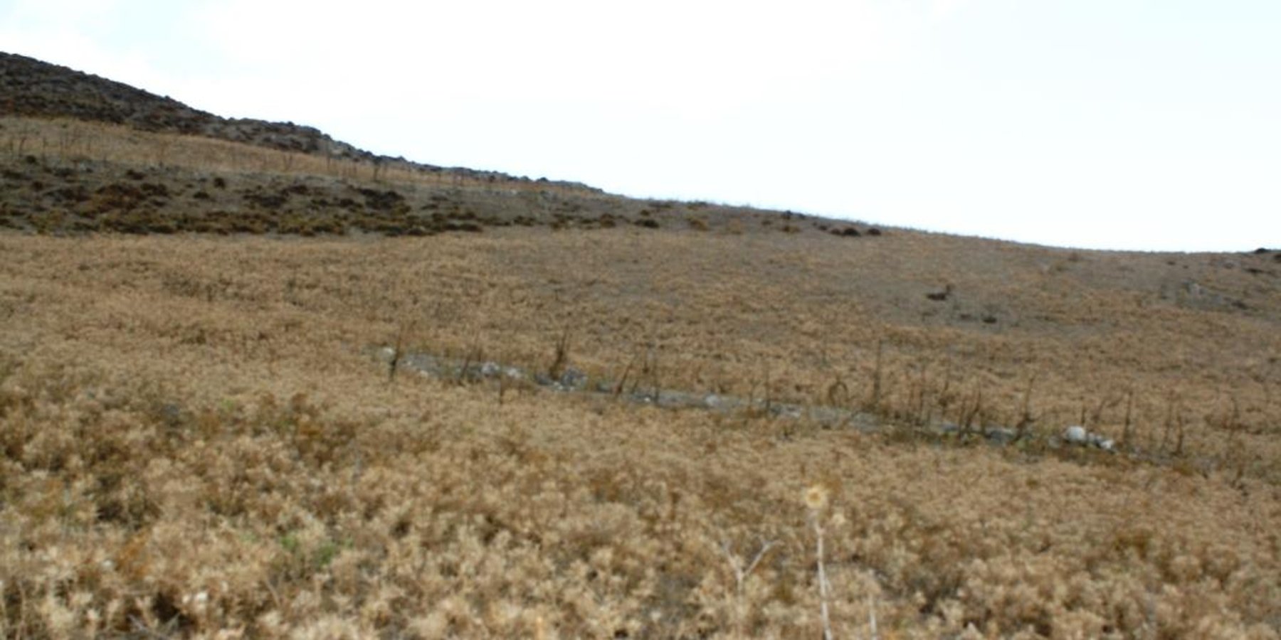
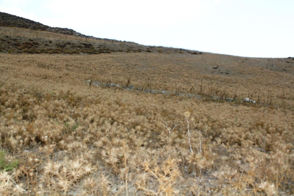
说明:
The technology is applied on semi-arid areas of Asteroussia Mountains of Crete used as grazing land with an annual rainfall between 501-750 mm. These areas are usually highly degraded, characterized by steep mountainous slopes (31-60%). This technology was mainly found in shallow (depth: 21-50 cm), moderately fine textured soils which moderate concentrations of soil organic matter (1-3%). The stock breeders in the region use a special regime for transferring livestock grazing rights from the communities to individuals. Nowadays the off farm income of breeders is between 10-50% of their total income.
Looking back, in the early 1950s to the 1980s the Asteroussia Mountains were a livestock-specialized area. Livestock production was based on controlled summer grazing in the mountains and overwintering in the lowlands. After the early 1960s, the area increasingly felt the impact of agricultural mechanization and - by consequence - excessive under-occupied rural labor force, which led to disproportionate out-migration from the area. In areas where limited natural capital was already fully utilized, such as in Asteroussia Mountains, further growth through increasing flocks was only possible by importing fodder. In a parallel, increasing intensification of agriculture in the nearby Messara plain limited the opportunities for the tradition of transhumance. Throughout the mid-1980s–2010s the economy remained livestock-dominated but the population decline continued. However, the presence of foreign migrants offering cheap labor from the early 1990s onwards contributed to keep many farms active.
Coming back to the technology, it consists of: (a) clearing natural vegetation, usually perennial shrubs accompanied with annual plants including mainly grasses, (b) sowing of high value palatable plant species for animals such as oat, vetch, etc. during winter, (c) allowing plants to grow adequately, and (d) grazing by the animals mainly during spring for a period of about one month, and (e) keeping the land bare until next wet cultivation period starts. The purpose is to increase the available biomass for the grazing animals in areas of low productivity of natural vegetation suitable for them. The major activities consists of clearing the land, plowing usually by a bulldoze type tractor, sowing the seeds and adding appropriate fertilizers. However, the establishment of this technology may face problems in clearing natural vegetation, if the existing Greek institutional framework does not allow doing it. Land degradation and desertification are very frequent processes in semi-arid areas and both processes have been enhanced in the last decades by climatic variations and human activities. The EU-funded research project DESIRE in Eastern and Western Europe, Latin America, Africa and Asia have identified soil erosion, forest fires, and overgrazing among the most important causes of land degradation. The main benefit of this technology therefore is the increase in the amount of high quality palatable biomass for the grazing animals in degraded lands. Land users like this technology, if the number of animals is high, as without the technology they face problems of feeding them. However, such an action increases the cost of animal production such as milk. In addition, soil erosion problems are expected since land remains bare for some period of the year especially after sowing the plants.
2.3 技术照片
媒体库

关于照片的一般说明:
Down-slope ploughing is more secure for the farmer and less energy consumption for the machine used.
2.5 已应用该技术的、本评估所涵盖的国家/地区/地点
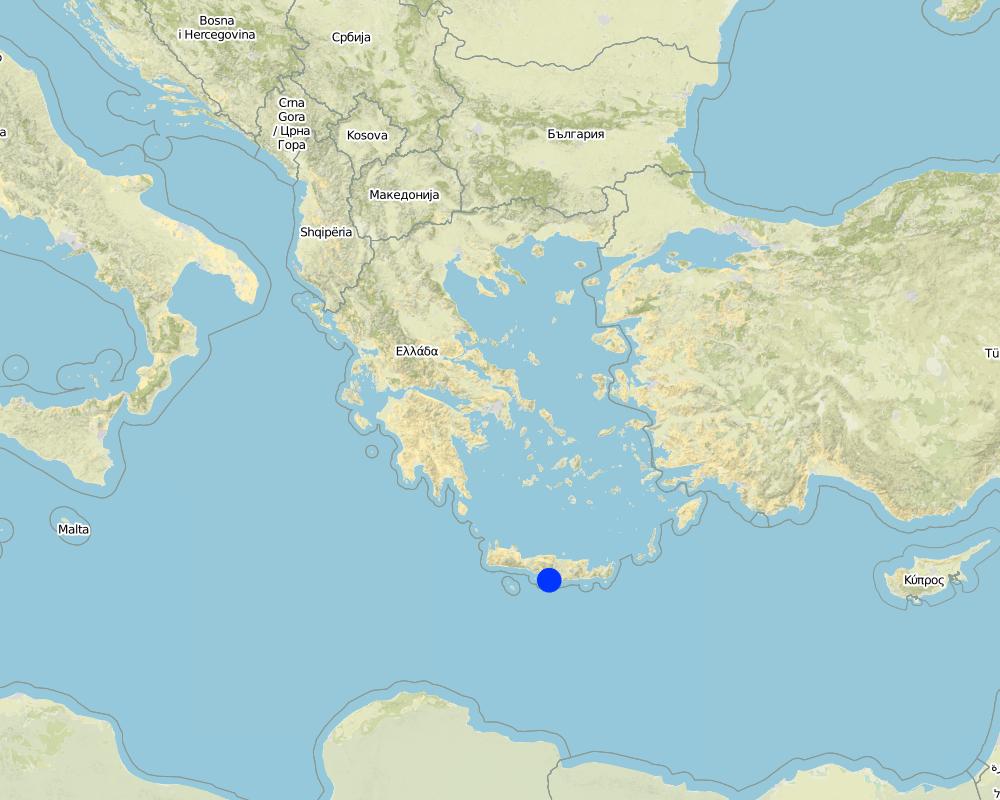
国家:
希腊
区域/州/省:
Crete, Heraklion province
有关地点的进一步说明:
Asteroussia Mountain, Paranimfi
Map
×2.6 实施日期
如果不知道确切的年份,请说明大概的日期:
- 10-50年前
2.7 技术介绍
详细说明该技术是如何引入的:
- 作为传统系统的一部分(> 50 年)
注释(项目类型等):
The technology continues to be applied since farmers are trying to produce more palatable biomass for the grazing animals as the productivity of the land with the natural vegetation is low.
3. SLM技术的分类
3.1 该技术的主要目的
- 改良生产
- 创造有益的经济影响
3.2 应用该技术的当前土地利用类型

牧场
粗放式放牧场:
- 经营牧场
集约放牧/饲料生产:
- 改良牧场
主要动物种类及产品:
Sheep and goats for meat and milk production
如果由于技术的实施而导致土地用途发生变化,则在技术实施前说明土地利的用途。:
Natural vegetation consisting mainly of shruby vegetation.
3.3 有关土地利用的更多信息
该技术所应用土地的供水:
- 雨养
每年的生长季节数:
- 1
牲畜密度(如相关):
20-25 animals/ha
3.4 该技术所属的SLM组
- 畜牧业和牧场管理
3.5 技术传播
具体说明该技术的分布:
- 均匀地分布在一个区域
如果该技术均匀地分布在一个区域上,请注明覆盖的大致区域。:
- < 0.1 平方千米(10 公顷)
注释:
Isolated fields with relatively deep soils and low slope gradient
3.6 包含该技术的可持续土地管理措施

农艺措施
- A1:植被和土壤覆盖层

植物措施
- V2:草和多年生草本植物
3.7 该技术强调的主要土地退化类型

土壤水蚀
- Wt:表土流失/地表侵蚀
3.8 防止、减少或恢复土地退化
具体数量名该技术与土地退化有关的目标:
- 减少土地退化
4. 技术规范、实施活动、投入和成本
4.1 该技术的技术图纸
作者:
Costas Kosmas
日期:
05/07/2017
4.2 技术规范/技术图纸说明
The technical specifications of the technology are known to almost all the people working on animal feeding. It requires a field of at least one hectare with the following soil characteristics: (a) soil depth of at least 30 cm, (b) soil texture medium to fine, (c) slope gradient less than 25%. In addition, the annual rainfall must be greater than 350 mm with an annual air temperature higher than 12° C.
4.3 有关投入和成本计算的一般信息
具体说明成本和投入是如何计算的:
- 每个技术区域
注明尺寸和面积单位:
one hectare
具体说明成本计算所用货币:
- 美元
注明雇用劳工的每日平均工资成本:
40
4.4 技术建立活动
| 活动 | 措施类型 | 时间 | |
|---|---|---|---|
| 1. | Clearing the field by mouldboard plough. | 农业学的 | November |
4.5 技术建立所需要的费用和投入
| 对投入进行具体说明 | 单位 | 数量 | 单位成本 | 每项投入的总成本 | 土地使用者承担的成本% | |
|---|---|---|---|---|---|---|
| 劳动力 | Clearing the field | person - days | 2.0 | 40.0 | 80.0 | 100.0 |
| 设备 | Tractor equiped with a mouldboard | 1 | 1.0 | 60.0 | 60.0 | 100.0 |
| 技术建立所需总成本 | 140.0 | |||||
4.6 维护/经常性活动
| 活动 | 措施类型 | 时间/频率 | |
|---|---|---|---|
| 1. | Ploughing | 农业学的 | once per year |
| 2. | Fertilization | 农业学的 | once per year |
| 3. | Sowing | 植物性的 | once per year |
4.7 维护/经常性活动所需要的费用和投入(每年)
| 对投入进行具体说明 | 单位 | 数量 | 单位成本 | 每项投入的总成本 | 土地使用者承担的成本% | |
|---|---|---|---|---|---|---|
| 劳动力 | Ploughing | person-days | 0.2 | 40.0 | 8.0 | 100.0 |
| 劳动力 | Sowing | person-days | 0.2 | 40.0 | 8.0 | 100.0 |
| 劳动力 | Fertilizing | person-days | 0.2 | 400.0 | 80.0 | 100.0 |
| 设备 | Tractor equiped with a mouldboard | 1 | 0.5 | 60.0 | 30.0 | 100.0 |
| 植物材料 | Seed | Kg/ha | 250.0 | 0.2 | 50.0 | 100.0 |
| 肥料和杀菌剂 | Fertilization | Kg/ha | 350.0 | 0.4 | 140.0 | 100.0 |
| 技术维护所需总成本 | 316.0 | |||||
4.8 影响成本的最重要因素
描述影响成本的最决定性因素:
Fertilizers and seeds
5. 自然和人文环境
5.1 气候
年降雨量
- < 250毫米
- 251-500毫米
- 501-750毫米
- 751-1,000毫米
- 1,001-1,500毫米
- 1,501-2,000毫米
- 2,001-3,000毫米
- 3,001-4,000毫米
- > 4,000毫米
指定年平均降雨量(若已知),单位为mm:
670.00
有关降雨的规范/注释:
Low-elevation areas receive an annual rainfall ranging between 500-750 mm, while the upper mountainous area (highest elevation: 1231 m at the sea level) receives up to 1250 mm of rain.
注明所考虑的参考气象站名称:
Hellenic National Meteorological Service, station of Gortina
农业气候带
- 半干旱
The majority of the area is characterized by an average air temperature ranging between 15°C and 18°C. Rainfall is falling from late fall to middle spring. The ETo (Potential Evapotranspiration) is high receiving values up to 1650 mm.
5.2 地形
平均坡度:
- 水平(0-2%)
- 缓降(3-5%)
- 平缓(6-10%)
- 滚坡(11-15%)
- 崎岖(16-30%)
- 陡峭(31-60%)
- 非常陡峭(>60%)
地形:
- 高原/平原
- 山脊
- 山坡
- 山地斜坡
- 麓坡
- 谷底
垂直分布带:
- 0-100 m a.s.l.
- 101-500 m a.s.l.
- 501-1,000 m a.s.l.
- 1,001-1,500 m a.s.l.
- 1,501-2,000 m a.s.l.
- 2,001-2,500 m a.s.l.
- 2,501-3,000 m a.s.l.
- 3,001-4,000 m a.s.l.
- > 4,000 m a.s.l.
说明该技术是否专门应用于:
- 不相关
关于地形的注释和进一步规范:
Hilly areas of various slopes and landforms. The Technology is only suitable for slope gradients less than 25%.
5.3 土壤
平均土层深度:
- 非常浅(0-20厘米)
- 浅(21-50厘米)
- 中等深度(51-80厘米)
- 深(81-120厘米)
- 非常深(> 120厘米)
土壤质地(表土):
- 中粒(壤土、粉土)
- 细粒/重质(粘土)
土壤质地(地表以下> 20厘米):
- 中粒(壤土、粉土)
- 细粒/重质(粘土)
表土有机质:
- 中(1-3%)
如有可能,附上完整的土壤描述或具体说明可用的信息,例如土壤类型、土壤酸碱度、阳离子交换能力、氮、盐度等。:
These soils are characterized by a surface A-horizon usually 12-18 cm thick and an underlying cambic B-horizon. Leptosols or Cambisols are the dominant soil units in the area. Soils are mainly moderately fine-textured. The 15-30 cm soil depth class is dominant throughout the area. Relatively deep soils (class 30-60 cm) have been mapped in patches. Some of these areas are used as cropland and grazing land. Slope gradient ranges between 2% and 60%. The slope class 35-60% is the dominant class covering the 49% of the total land. The minimum soil depth necessary for the Technology is 30 cm.
5.4 水资源可用性和质量
地下水位表:
> 50米
地表水的可用性:
匮乏/没有
水质(未处理):
良好饮用水
水的盐度有问题吗?:
否
该区域正在发生洪水吗?:
否
5.5 生物多样性
物种多样性:
- 高
栖息地多样性:
- 中等
关于生物多样性的注释和进一步规范:
The most important land cover types are schlerophyllous vegetation, transitional woodland-shrubs and sparsely vegetated areas covering the 88% of the total area. The rest of the area is covered by agricultural crops, mainly olive trees and cereals. The dominant woody plant species in the area include Olea sylvestris, Olea Europa, Salix alba (along watercourses), Pyrus amygdaliformis, Prunus webbii, Thymus capitatus, Salvia triloba, Flomis lanata, Flomis fruticosa, Sarcopoterium spinosum, Calicotome vilosa, Scilla maritime, Asfodelus aestivus, Euphorbia characias. Overgrazing coupled with frequent fires shaped the vegetation pattern in the area determining the predominance of the less palatable fire-tolerant plant species. The above-mentioned state of biodiversity existed before clearing the land even in degraded areas.
5.6 应用该技术的土地使用者的特征
定栖或游牧:
- 定栖的
生产系统的市场定位:
- 混合(生计/商业
非农收入:
- 收入的10-50%
相对财富水平:
- 平均水平
个人或集体:
- 个人/家庭
机械化水平:
- 机械化/电动
性别:
- 男人
土地使用者的年龄:
- 中年人
5.7 应用该技术的土地使用者拥有或租用的平均土地面积
- < 0.5 公顷
- 0.5-1 公顷
- 1-2 公顷
- 2-5公顷
- 5-15公顷
- 15-50公顷
- 50-100公顷
- 100-500公顷
- 500-1,000公顷
- 1,000-10,000公顷
- > 10,000公顷
这被认为是小规模、中规模还是大规模的(参照当地实际情况)?:
- 中等规模的
5.8 土地所有权、土地使用权和水使用权
土地所有权:
- 州
- 个人,有命名
土地使用权:
- 社区(有组织)
用水权:
- 社区(有组织)
注释:
Nowadays in Crete livestock grazing is allowed due to a special regime for transferring grazing rights from the communities to individuals (Papanastasis, 1993).
5.9 进入服务和基础设施的通道
健康:
- 贫瘠
- 适度的
- 好
教育:
- 贫瘠
- 适度的
- 好
技术援助:
- 贫瘠
- 适度的
- 好
就业(例如非农):
- 贫瘠
- 适度的
- 好
市场:
- 贫瘠
- 适度的
- 好
能源:
- 贫瘠
- 适度的
- 好
道路和交通:
- 贫瘠
- 适度的
- 好
饮用水和卫生设施:
- 贫瘠
- 适度的
- 好
金融服务:
- 贫瘠
- 适度的
- 好
6. 影响和结论性说明
6.1 该技术的现场影响
社会经济效应
生产
饲料生产
注释/具体说明:
Increase in biomass production for feeding the animals
畜牧生产
注释/具体说明:
In consequence of increased fodder production
生态影响
水循环/径流
地表径流
注释/具体说明:
There are not available data on surface runoff for the area.
土壤
土壤水分
SLM之前的数量:
-1
SLM之后的数量:
1
土壤流失
SLM之前的数量:
1
SLM之后的数量:
-1
注释/具体说明:
Increase in soil erosion due to removal of natural vegetation
生物多样性:植被、动物
植物多样性
注释/具体说明:
Because the natural vegetation is cleared.
6.2 该技术的场外影响已经显现
下游洪水
注释/具体说明:
The soil sediments are transported in the low land of Messara valley or into the sea.
6.3 技术对渐变气候以及与气候相关的极端情况/灾害的暴露和敏感性(土地使用者认为的极端情况/灾害)
渐变气候
渐变气候
| 季节 | 气候变化/极端天气的类型 | 该技术是如何应对的? | |
|---|---|---|---|
| 年温度 | 增加 | 适度 |
6.4 成本效益分析
技术收益与技术建立成本相比如何(从土地使用者的角度看)?
短期回报:
积极
长期回报:
积极
技术收益与技术维护成本/经常性成本相比如何(从土地使用者的角度看)?
短期回报:
积极
长期回报:
积极
6.5 技术采用
- 大于 50%
在所有采用这项技术的人当中,有多少人是自发地采用该技术,即未获得任何物质奖励/付款?:
- 90-100%
6.6 适应
最近是否对该技术进行了修改以适应不断变化的条件?:
否
6.7 该技术的优点/长处/机会
| 土地使用者眼中的长处/优势/机会 |
|---|
| The advantage of the technology is the increase of biomass production for feeding the animals in areas of low natural grass production. |
| 编制者或其他关键资源人员认为的长处/优势/机会 |
|---|
| The advantage of the technology is the increase of biomass production for feeding the animals in areas of low natural grass production. |
6.8 技术的弱点/缺点/风险及其克服方法
| 土地使用者认为的弱点/缺点/风险 | 如何克服它们? |
|---|---|
| Decline of biodiversity | |
| Create some problems of soil erosion during installation |
| 编制者或其他关键资源人员认为的弱点/缺点/风险 | 如何克服它们? |
|---|---|
| Decline of biodiversity | |
| Soil erosion at the initial stage of ploughing the land | From the increase in soil plant cover |
7. 参考和链接
7.1 信息的方法/来源
- 实地考察、实地调查
Mapping the whole area in a scale 1:30,000
- 与土地使用者的访谈
Land users have complete questionnaires during the execution of the EU research project LEDDRA
7.2 参考可用出版物
标题、作者、年份、ISBN:
Costas Kosmas, Vassilis Detsis, Mina Karamesouti, Kate Kounalaki, Penny Vassiliou and Luca Salvati. 2015. Exploring Long-Term Impact of Grazing Management on Land Degradation in the Socio-Ecological System of Asteroussia Mountains, Greece Land 4:541-559 doi:10.3390/land4030541.
可以从哪里获得?成本如何?
URL: http://www.mdpi.com/2073-445X/4/3/541/htm
标题、作者、年份、ISBN:
Papanastasis, V., 1993. Legal status of land tenure and use and its implication for open landscapes of western Crete. Landscape and Urban Planning, 24, 273-277.
7.3 链接到网络上可用的相关信息
标题/说明:
European framework EC-DG RTD, 7th Framework Research Programme (sub-priority ENV-2009-2.1.3.2), Research on Desertification Process and Land Degradation, project LEDDRA (243857): Land and Ecosystem Degradation and Desertification: Assessing the Fit of Responses.
链接和模块
全部展开 全部收起链接
无链接
模块
无模块