Recharge well [突尼斯]
- 创建:
- 更新:
- 编制者: Mongi Ben Zaied
- 编辑者: –
- 审查者: Deborah Niggli
Puits de recharge (French)
technologies_1412 - 突尼斯
查看章节
全部展开 全部收起1. 一般信息
1.2 参与该技术评估和文件编制的资源人员和机构的联系方式
关键资源人
SLM专业人员:
Chniter Mongi
Commissariats Régionaux au Développement Agricole CRDA
4100 Medenine, Tunisia
突尼斯
SLM专业人员:
Yahyaoui Houcine
Commissariats Régionaux au Développement Agricole CRDA
4100 Medenine, Tunisia
突尼斯
SLM专业人员:
有助于对技术进行记录/评估的项目名称(如相关)
DESIRE (EU-DES!RE)有助于对技术进行记录/评估的机构名称(如相关)
Commissariats Régionaux au Développement Agricole (CRDA) - 突尼斯有助于对技术进行记录/评估的机构名称(如相关)
Institut des Régions Arides de Médenine (Institut des Régions Arides de Médenine) - 突尼斯1.3 关于使用通过WOCAT记录的数据的条件
(现场)数据是什么时候汇编的?:
10/06/2011
编制者和关键资源人员接受有关使用通过WOCAT记录数据的条件。:
是
1.5 请参阅有关SLM方法的问卷
Dryland watershed management approach [突尼斯]
Integrated land and water management approach, including vegetative, management, and agronomic measure
- 编制者: Naceur Mahdi
2. SLM技术的说明
2.1 技术简介
技术定义:
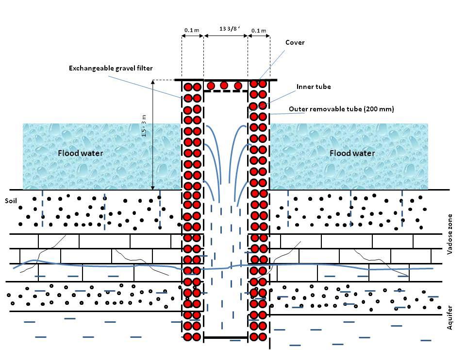
A recharge well comprises a drilled hole, up to 30-40 m deep that reaches the water table, and a surrounding filter used to allow the direct injection of floodwater into the aquifer.
2.2 技术的详细说明
说明:
The main worldwide used methods to enhance groundwater replenishment are through recharge basins or recharge wells. Though groundwater recharge aiming at storage of water in the periods of abundance for recovery in times of drought has a long history dating back millennia, the recharge wells began to be used only in the twentieth century, especially during the Second World War following concerns on attacks of the water supply facilities. Its use was extended later to sea intrusion control, treated waste water, water harvesting in the dry areas, and strategic water storage.
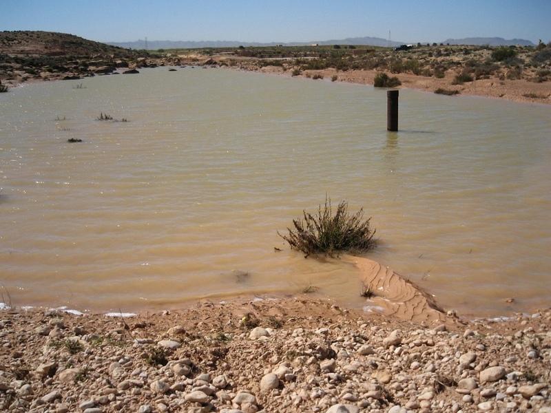
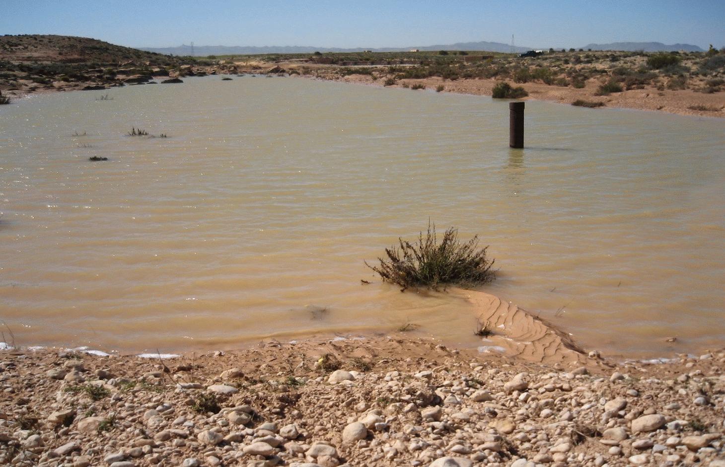
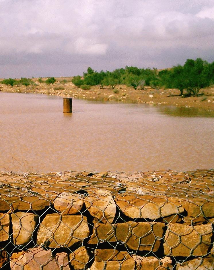
Purpose of the Technology: Recharge wells are used in combination with gabion check dams to enhance the infiltration of floodwater into the aquifer. In areas where the permeability of the underlying bedrock in front of a gabion is judged too low, recharge wells could be installed in wadi (ephemeral river) beds. Water is retained by the gabion check dam and it flows through the recharge well allowing accelerated percolation into the aquifer.
Establishment / maintenance activities and inputs: A recharge well consists of a long inner tube surrounded by an outer tube, the circumference of which ranges between 1 and 2 m. The area between the tubes is filled with river bed gravel which acts as a sediment filter. Water enters the well through rectangular-shaped openings (almost 20 cm long and a few mm in width) located in the outer tube, and it flows in the inner hole having passed through the gravel and the rectangular shaped openings of the dill hole. The above-ground height is around 2 to 3 m whereas the depth is linked to the depth of the water table (normally up to 40 m). The drill hole connects directly with the aquifer, where it is connected either directly with the water table or indirectly via cracks. Pond volume is dependent on the size of the gabion check dam but generally ranges between 500 and 3000 m3. The filtered water can directly flow into the aquifer at a rate exceeding what would occur naturally through the soil and the underlying strata.
The design should be conducted primarily by a hydrogeologist and a soil and water conservation specialist in order to determine the potential sites and the required drilling equipment. Drilling needs to be carried out by a specialized company.
Depending on the geological setting, the overall cost is around 5000 to 10000 US$. The recharge wells are used to recharge the deep groundwater aquifers, which are mainly exploited by government agencies. However, private irrigated farms are benefiting indirectly by increased groundwater availability.
Natural / human environment: This technique has been first tried for the replenishment of the Zeuss-Koutine aquifer (south east Tunisia).
2.3 技术照片
媒体库
2.5 已应用该技术的、本评估所涵盖的国家/地区/地点
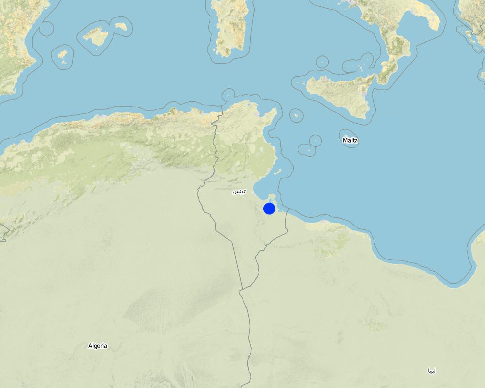
国家:
突尼斯
区域/州/省:
Medenine
有关地点的进一步说明:
Medenine nord
Map
×2.6 实施日期
如果不知道确切的年份,请说明大概的日期:
- 10-50年前
2.7 技术介绍
详细说明该技术是如何引入的:
- 通过项目/外部干预
3. SLM技术的分类
3.2 应用该技术的当前土地利用类型

农田
- 乔木与灌木的种植

牧场
注释:
Major land use problems (compiler’s opinion): Runoff water loss, riverbank erosion, flooding risk, aridity
Major land use problems (land users’ perception): water loss
Constraints of wadi beds
3.3 有关土地利用的更多信息
每年的生长季节数:
- 1
具体说明:
Longest growing period in days: 180Longest growing period from month to month: Oct - Apr
3.4 该技术所属的SLM组
- 集水
- 地下水管理
3.5 技术传播
具体说明该技术的分布:
- 均匀地分布在一个区域
如果该技术均匀地分布在一个区域上,请注明覆盖的大致区域。:
- 10-100 平方千米
3.6 包含该技术的可持续土地管理措施

结构措施
- S11:其它
注释:
Main measures: structural measures
3.7 该技术强调的主要土地退化类型

土壤水蚀
- Wr:河岸侵蚀
- Wo:场外劣化效应

水质恶化
- Ha:干旱化
- Hq:地下水水质下降
注释:
Main type of degradation addressed: Ha: aridification
Secondary types of degradation addressed: Wr: riverbank erosion, Wo: offsite degradation effects, Hq: decline of groundwater quality
Main causes of degradation: over abstraction / excessive withdrawal of water (for irrigation, industry, etc.)
Secondary causes of degradation: disturbance of water cycle (infiltration / runoff), Heavy / extreme rainfall (intensity/amounts)
3.8 防止、减少或恢复土地退化
具体数量名该技术与土地退化有关的目标:
- 防止土地退化
- 减少土地退化
注释:
Main goals: prevention of land degradation
Secondary goals: mitigation / reduction of land degradation
4. 技术规范、实施活动、投入和成本
4.1 该技术的技术图纸
作者:
Ouessar M., Medenine, Tunisia
4.2 技术规范/技术图纸说明
Schematic representation of the main components of a recharge well. The flood water retained behind the gabion check dam flows through the outer tube and the gravel filter into the water table. Clogging of the filter is one of the major problems to be considered and solved.
south east Tunisia
Date: January 2009
Technical knowledge required for field staff / advisors: moderate
Main technical functions: increase of groundwater level / recharge of groundwater
Secondary technical functions: control of concentrated runoff: retain / trap, water harvesting / increase water supply
Structural measure: Casting tube
Spacing between structures (m): 100-500
Depth of ditches/pits/dams (m): 30-40m
Width of ditches/pits/dams (m): 0.5-1m
Structural measure: Filter
Construction material (other): Plastic/iron: the casting tube, Gravel: for the filter
4.3 有关投入和成本计算的一般信息
其它/国家货币(具体说明):
TND
注明美元与当地货币的汇率(如相关):1美元=:
1.3
注明雇用劳工的每日平均工资成本:
10.00
4.4 技术建立活动
| 活动 | 措施类型 | 时间 | |
|---|---|---|---|
| 1. | Drilling | 结构性的 | |
| 2. | Installation | 结构性的 |
4.5 技术建立所需要的费用和投入
| 对投入进行具体说明 | 单位 | 数量 | 单位成本 | 每项投入的总成本 | 土地使用者承担的成本% | |
|---|---|---|---|---|---|---|
| 劳动力 | Labour | ha | 1.0 | 7000.0 | 7000.0 | |
| 施工材料 | ha | 1.0 | 1000.0 | 1000.0 | ||
| 技术建立所需总成本 | 8000.0 | |||||
注释:
Duration of establishment phase: 3 month(s)
4.6 维护/经常性活动
| 活动 | 措施类型 | 时间/频率 | |
|---|---|---|---|
| 1. | Desilting of the filter | 结构性的 | Ounce in 1-3years (floods) |
| 2. | Repairs | 结构性的 |
4.7 维护/经常性活动所需要的费用和投入(每年)
| 对投入进行具体说明 | 单位 | 数量 | 单位成本 | 每项投入的总成本 | 土地使用者承担的成本% | |
|---|---|---|---|---|---|---|
| 劳动力 | Labour | ha | 1.0 | 500.0 | 500.0 | |
| 施工材料 | ha | 1.0 | 100.0 | 100.0 | ||
| 技术维护所需总成本 | 600.0 | |||||
4.8 影响成本的最重要因素
描述影响成本的最决定性因素:
Labour is the most determining factor affecting the costs.
5. 自然和人文环境
5.1 气候
年降雨量
- < 250毫米
- 251-500毫米
- 501-750毫米
- 751-1,000毫米
- 1,001-1,500毫米
- 1,501-2,000毫米
- 2,001-3,000毫米
- 3,001-4,000毫米
- > 4,000毫米
农业气候带
- 干旱
Thermal climate class: subtropics
5.2 地形
平均坡度:
- 水平(0-2%)
- 缓降(3-5%)
- 平缓(6-10%)
- 滚坡(11-15%)
- 崎岖(16-30%)
- 陡峭(31-60%)
- 非常陡峭(>60%)
地形:
- 高原/平原
- 山脊
- 山坡
- 山地斜坡
- 麓坡
- 谷底
垂直分布带:
- 0-100 m a.s.l.
- 101-500 m a.s.l.
- 501-1,000 m a.s.l.
- 1,001-1,500 m a.s.l.
- 1,501-2,000 m a.s.l.
- 2,001-2,500 m a.s.l.
- 2,501-3,000 m a.s.l.
- 3,001-4,000 m a.s.l.
- > 4,000 m a.s.l.
5.3 土壤
平均土层深度:
- 非常浅(0-20厘米)
- 浅(21-50厘米)
- 中等深度(51-80厘米)
- 深(81-120厘米)
- 非常深(> 120厘米)
土壤质地(表土):
- 中粒(壤土、粉土)
表土有机质:
- 低(<1%)
如有可能,附上完整的土壤描述或具体说明可用的信息,例如土壤类型、土壤酸碱度、阳离子交换能力、氮、盐度等。:
Soil fertility is very low
Soil drainage / infiltration is medium
Soil water storage is medium
5.4 水资源可用性和质量
地下水位表:
5-50米
地表水的可用性:
匮乏/没有
水质(未处理):
不良饮用水(需要处理)
关于水质和水量的注释和进一步规范:
Seasonal fluctuations: Availability of surface water is poor/none but with periods of excess (e.g. flood)
5.5 生物多样性
物种多样性:
- 中等
5.6 应用该技术的土地使用者的特征
生产系统的市场定位:
- 混合(生计/商业
非农收入:
- > 收入的50%
相对财富水平:
- 平均水平
个人或集体:
- 员工(公司、政府)
说明土地使用者的其他有关特征:
Population density: 10-50 persons/km2
Annual population growth: 0.5% - 1%
70% of the land users are average wealthy and own 75% of the land.
5.7 应用该技术的土地使用者拥有或租用的平均土地面积
- < 0.5 公顷
- 0.5-1 公顷
- 1-2 公顷
- 2-5公顷
- 5-15公顷
- 15-50公顷
- 50-100公顷
- 100-500公顷
- 500-1,000公顷
- 1,000-10,000公顷
- > 10,000公顷
5.8 土地所有权、土地使用权和水使用权
土地所有权:
- 州
土地使用权:
- 社区(有组织)
用水权:
- 社区(有组织)
注释:
The recharge wells are used to recharge the deep groundwater aquifers which are mainly exploited by the government agencies. However, private irrigated farms could benefit indirectly, by increased groundwater availability.
5.9 进入服务和基础设施的通道
健康:
- 贫瘠
- 适度的
- 好
教育:
- 贫瘠
- 适度的
- 好
技术援助:
- 贫瘠
- 适度的
- 好
就业(例如非农):
- 贫瘠
- 适度的
- 好
市场:
- 贫瘠
- 适度的
- 好
能源:
- 贫瘠
- 适度的
- 好
道路和交通:
- 贫瘠
- 适度的
- 好
饮用水和卫生设施:
- 贫瘠
- 适度的
- 好
金融服务:
- 贫瘠
- 适度的
- 好
6. 影响和结论性说明
6.1 该技术的现场影响
社会经济效应
水资源可用性和质量
饮用水的可用性
家畜用水的可用性
灌溉用水的可用性
社会文化影响
SLM/土地退化知识
冲突缓解
Improved livelihoods and human well-being
注释/具体说明:
Increased availability of water for drinking, agriculture and livestock
生态影响
水循环/径流
水的回收/收集
地下水位/含水层
土壤
盐度
其它生态影响
risks of contamination of aquifers
6.2 该技术的场外影响已经显现
水资源可用性
下游洪水
注释/具体说明:
In combination with gabion check dams
对公共/私人基础设施的破坏
注释/具体说明:
In combination with gabion check dams
Surface water to reach downstream areas
6.3 技术对渐变气候以及与气候相关的极端情况/灾害的暴露和敏感性(土地使用者认为的极端情况/灾害)
渐变气候
渐变气候
| 季节 | 气候变化/极端天气的类型 | 该技术是如何应对的? | |
|---|---|---|---|
| 年温度 | 增加 | 好 |
气候有关的极端情况(灾害)
气象灾害
| 该技术是如何应对的? | |
|---|---|
| 局地暴雨 | 好 |
| 局地风暴 | 好 |
气候灾害
| 该技术是如何应对的? | |
|---|---|
| 干旱 | 好 |
其他气候相关的后果
其他气候相关的后果
| 该技术是如何应对的? | |
|---|---|
| 缩短生长期 | 好 |
| extreme floods | 不好 |
6.4 成本效益分析
技术收益与技术建立成本相比如何(从土地使用者的角度看)?
短期回报:
非常积极
长期回报:
积极
技术收益与技术维护成本/经常性成本相比如何(从土地使用者的角度看)?
短期回报:
非常积极
长期回报:
积极
注释:
Long-term benefits are slightly reduced due to silting problems.
6.5 技术采用
在所有采用这项技术的人当中,有多少人是自发地采用该技术,即未获得任何物质奖励/付款?:
- 0-10%
注释:
Comments on acceptance with external material support: It is solely constrcuted by the government agencies.
6.7 该技术的优点/长处/机会
| 土地使用者眼中的长处/优势/机会 |
|---|
|
Replenishment of the aquifer How can they be sustained / enhanced? Good selection of the site and drilling methods |
| 编制者或其他关键资源人员认为的长处/优势/机会 |
|---|
| Enhance groundwater level and quality (reduce salinity) |
6.8 技术的弱点/缺点/风险及其克服方法
| 土地使用者认为的弱点/缺点/风险 | 如何克服它们? |
|---|---|
| Retain water for dowstreams users | Proper watershed management plan |
| 编制者或其他关键资源人员认为的弱点/缺点/风险 | 如何克服它们? |
|---|---|
| Silting up of the filter | Maintenance of the filters. |
| Malfunction due to aquifer geometry and characteristics | Good selection of the sites |
7. 参考和链接
7.2 参考可用出版物
标题、作者、年份、ISBN:
Yahyaoui, H., Ouessar, M. 2000. Abstraction and recharge impacts on the ground water in the arid regions of Tunisia: Case of Zeuss-Koutine water table. UNU Desertification Series, 2: 72-78.
可以从哪里获得?成本如何?
IRA, CRDA-Medenine, UNU
标题、作者、年份、ISBN:
Yahyaoui, H., Chaieb, H., Ouessar, M. 2002. Impact des travaux de conservation des eaux et des sols sur la recharge de la nappe de Zeuss-Koutine (Médenine: Sud-est tunisien). TRMP paper n° 40, Wageningen University, The Netherlands, pp: 71-86.
可以从哪里获得?成本如何?
IRA, Wegeningen University (NL),
标题、作者、年份、ISBN:
Temmerman, S. 2004. Evaluation of the efficiency of recharge wells on the water supply to the water table in South Tunisia. Graduation dissertation, Ghent University, Belgium.
可以从哪里获得?成本如何?
IRA, Gent University (BE)
标题、作者、年份、ISBN:
Genin, D., Guillaume, H., Ouessar, M., Ouled Belgacem, A., Romagny, B., Sghaier, M., Taamallah, H. (eds) 2006. Entre la désertification et le développement : la Jeffara tunisienne. CERES, Tunis, 351 pp.
可以从哪里获得?成本如何?
IRA, IRD
标题、作者、年份、ISBN:
Ouessar M. 2007. Hydrological impacts of rainwater harvesting in wadi Oum Zessar watershed (Southern Tunisia). Ph.D. thesis, Faculty of Bioscience Engineering, Ghent University, Ghent, Belgium, 154 pp.
可以从哪里获得?成本如何?
IRA, Gent University (BE)
链接和模块
全部展开 全部收起链接
Dryland watershed management approach [突尼斯]
Integrated land and water management approach, including vegetative, management, and agronomic measure
- 编制者: Naceur Mahdi
模块
无模块