Earth checks for Gully reclamation [埃塞俄比亚]
- 创建:
- 更新:
- 编制者: Daniel Danano
- 编辑者: –
- 审查者: Fabian Ottiger, Alexandra Gavilano
technologies_1069 - 埃塞俄比亚
查看章节
全部展开 全部收起1. 一般信息
1.2 参与该技术评估和文件编制的资源人员和机构的联系方式
SLM专业人员:
Estifanos Zena
Ministry of Agriculture and Rural Development
埃塞俄比亚
SLM专业人员:
Desta Hiwot
Boditi, Department of Agriculture and Rural Development
埃塞俄比亚
有助于对技术进行记录/评估的机构名称(如相关)
FAO Food and Agriculture Organization (FAO Food and Agriculture Organization) - 意大利有助于对技术进行记录/评估的机构名称(如相关)
Ministry of Agriculture and Rural Development (Ministry of Agriculture and Rural Development) - 埃塞俄比亚1.3 关于使用通过WOCAT记录的数据的条件
编制者和关键资源人员接受有关使用通过WOCAT记录数据的条件。:
是
2. SLM技术的说明
2.1 技术简介
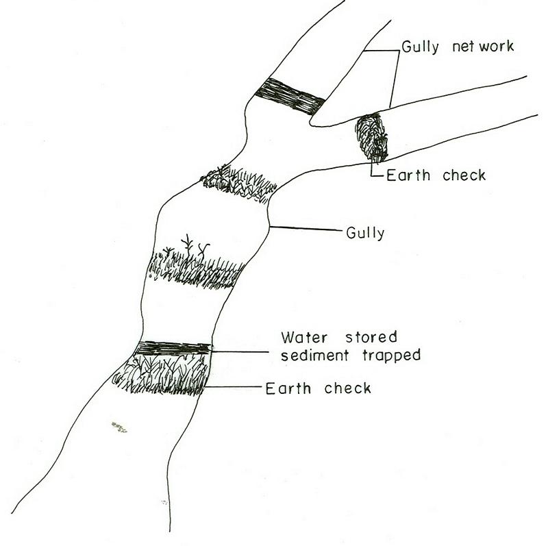
技术定义:
Earh-checks are constructed of earth embankment put across in a deep gully in such a way to trap sediment and store water passing by it.
2.2 技术的详细说明
说明:
Active deep gullies are plugged by digging earth from the bottom as well as gully sides and embanked forming a barrier to runoff passing through it. The embankment is reinforced by planting useful plants such as banana, sesbania, gravillea, gesho, etc., The purpose is to rehabilitate gullies having depth and expand along sides and towards the head. By constructing earth checks the water is stored in the checks. The water percolates down the ground enriching the ground water. The soil is trapped in the checks and later brings up the gully gradient higher. As a result, a cultivable/cropable strip is formed. Weeding and cultivation done to plants established.The gully fence and breaks are repaired. The technology is seen to be suitable to humid highlands where land loss by gully is a serious problem and land under cultivation and grazing is getting here and there. In brief it is suitable in areas where land degradation problem is increasing with currently cultivated and grazed lands are encroched by gully expansion.
2.3 技术照片
媒体库
2.5 已应用该技术的、本评估所涵盖的国家/地区/地点
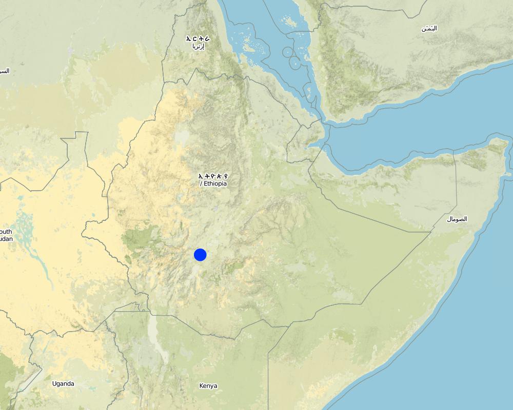
国家:
埃塞俄比亚
区域/州/省:
SNNPR
有关地点的进一步说明:
SNNPR/Damot Galle/Bilate
注释:
Total area covered by the SLM Technology is 51.2 km2.
Map
×2.6 实施日期
如果不知道确切的年份,请说明大概的日期:
- 不到10年前(最近)
2.7 技术介绍
详细说明该技术是如何引入的:
- 通过项目/外部干预
注释(项目类型等):
The technology is introduced but highly modified by adjesting design, layout and by increasing use of locally available materials for construction.
3. SLM技术的分类
3.1 该技术的主要目的
- 减少、预防、恢复土地退化
3.2 应用该技术的当前土地利用类型
同一土地单元内混合使用的土地::
是
具体说明混合土地使用(作物/放牧/树木):
- 农林牧业

农田
- 一年一作
- 多年一作(非木材)
- 乔木与灌木的种植
年作 - 具体指明作物:
- 谷物类 - 玉米
- 谷类 - 高粱
- 根/块茎作物 - 红薯、山药、芋头/椰子,其他
- 根/块茎作物 - 木薯
- 根/块茎作物 - 土豆
乔木和灌木种植 - 指定作物:
- 鳄梨
- 水果、其他
- 芒果、山竹果、番石榴
- 木瓜
- enset, taro, sugar cane, Leucaena, Sesbania, Grevillea
每年的生长季节数:
- 2
具体说明:
Longest growing period in days: 210 Longest growing period from month to month: Apr - Oct Second longest growing period in days: 180 Second longest growing period from month to month: Aug - Jun
采用间作制度了吗?:
是
如果是,说明哪些作物是间作的:
maize-sweet potato/haricot bean
采用轮作制度了吗?:
是
如果是,请具体说明:
maize-tarro-sorghum

牧场
动物类型:
- 牛 - 奶制品
- 马
- donkeys, oxen

森林/林地
产品和服务:
- 木材
- 薪材
- 放牧/啃牧
注释:
Major land use problems (compiler’s opinion): Monocropping, soil erosion, fertility mining, overgrazing, improper runoff management.
Grazingland comments: Livestock such as cows, oxen, donkeys and horse are thethered at a very small piece of land left infront of houses usually meant for social purposes. Some farmers thether their animals in a piece of land left uncropped in the field. The most part of livestock feed comes from crop residue which is collected from crop fields. Maize stalk, teff straw and enset leaves are fed stall.
Forest products and services: timber, fuelwood, grazing / browsing
Type of cropping system and major crops comments: Maize-sweet potato-Teff-potato-sorghum
3.4 供水
该技术所应用土地的供水:
- 雨养
3.5 该技术所属的SLM组
- 横坡措施
- 集水
3.6 包含该技术的可持续土地管理措施
3.7 该技术强调的主要土地退化类型

土壤水蚀
- Wt:表土流失/地表侵蚀
- Wg:冲沟侵蚀/沟蚀

化学性土壤退化
- Cn:肥力下降和有机质含量下降(非侵蚀所致)
注释:
Main type of degradation addressed: Wt: loss of topsoil / surface erosion, Wg: gully erosion / gullying
Secondary types of degradation addressed: Cn: fertility decline and reduced organic matter content
3.8 防止、减少或恢复土地退化
具体数量名该技术与土地退化有关的目标:
- 防止土地退化
- 减少土地退化
注释:
Main goals: Also rehabilitation / reclamation of denuded land
4. 技术规范、实施活动、投入和成本
4.1 该技术的技术图纸
技术规范(与技术图纸相关):
SNNPR
Technical knowledge required for field staff / advisors: high
Technical knowledge required for land users: moderate
Main technical functions: water harvesting / increase water supply, sediment retention / trapping, sediment harvesting
Secondary technical functions: control of concentrated runoff: retain / trap, reduction of slope angle, reduction of slope length
Early planting
Material/ species: maize
Quantity/ density: 85000/ha
Remarks: sawn in lines
Mixed cropping / intercropping
Material/ species: maize-sweet potato/haricot bean
Remarks: inter cropped & strip cropped
Contour planting / strip cropping
Material/ species: maize-taro-enset
Mulching
Material/ species: enset
Manure / compost / residues
Material/ species: maize, potato, sweet potato, traro
Mineral (inorganic) fertilizers
Material/ species: Teff, maize, sorghum
Rotations / fallows
Material/ species: maize-tarro-sorghum
Remarks: only rotations
Breaking compacted topsoil
Remarks: primary and secondary oxen tillage
Contour tillage
Remarks: tillage done following contour
Agronomic measure: harrowing
Aligned: -contour
Vegetative material: O : other
Vertical interval between rows / strips / blocks (m): 0.2-0.5
Spacing between rows / strips / blocks (m): 2-4
Vertical interval within rows / strips / blocks (m): 0.5-2
Width within rows / strips / blocks (m): 0.5-1
Scattered / dispersed
Vegetative material: T : trees / shrubs
Number of plants per (ha): 4000
Vertical interval between rows / strips / blocks (m): 0.2
Spacing between rows / strips / blocks (m): 1.5x1.5
Vertical interval within rows / strips / blocks (m): 1.5
Width within rows / strips / blocks (m): 1.5
In blocks
Vegetative material: T : trees / shrubs
Number of plants per (ha): 2500
Vertical interval between rows / strips / blocks (m): 0.5
Spacing between rows / strips / blocks (m): 2x2
Vertical interval within rows / strips / blocks (m): 2
Width within rows / strips / blocks (m): 2
Trees/ shrubs species: Leucaena, Sesbania, Grevillea
Fruit trees / shrubs species: Mango, papaya, Avocado
Perennial crops species: Casava
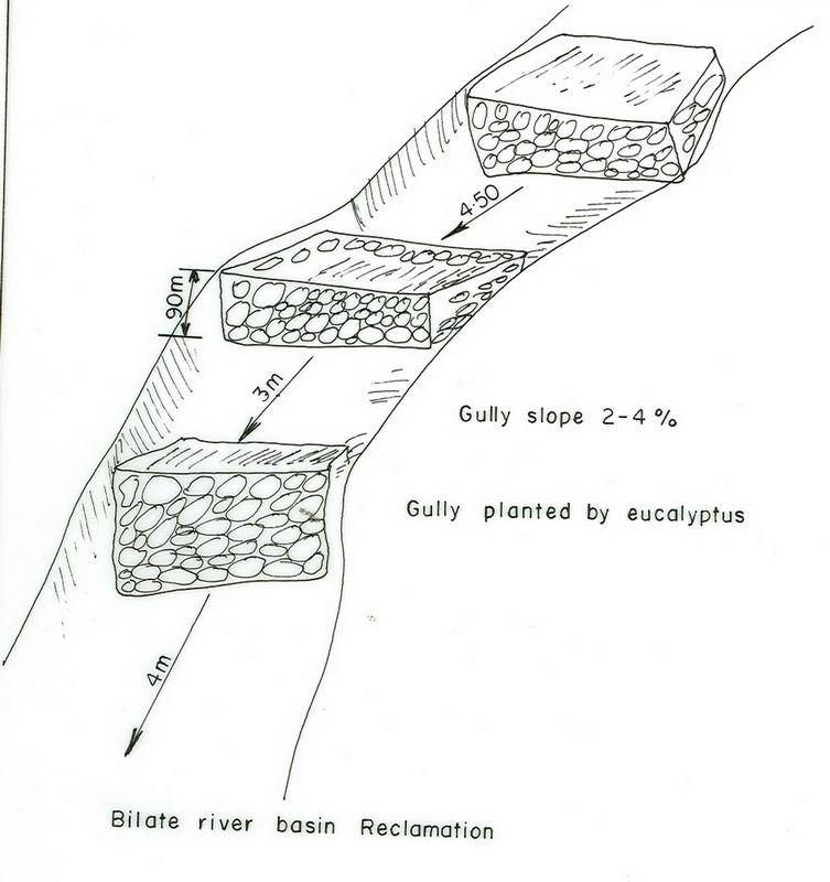
Slope (which determines the spacing indicated above): 10.00%
If the original slope has changed as a result of the Technology, the slope today is (see figure below): 8.00%
Gradient along the rows / strips: 0.00%
Diversion ditch/ drainage
Depth of ditches/pits/dams (m): 0.5
Width of ditches/pits/dams (m): 0.5
Length of ditches/pits/dams (m): 100
Height of bunds/banks/others (m): 0.6
Width of bunds/banks/others (m): 0.5
Length of bunds/banks/others (m): 100
Retention/infiltration ditch/pit, sediment/sand trap
Vertical interval between structures (m): 0.5
Depth of ditches/pits/dams (m): 0.6
Width of ditches/pits/dams (m): 0.7
Length of ditches/pits/dams (m): 4
Height of bunds/banks/others (m): 0.75
Width of bunds/banks/others (m): 0.6
Terrace: backward sloping
Vertical interval between structures (m): 1.5
Spacing between structures (m): 12
Depth of ditches/pits/dams (m): 0.9
Width of ditches/pits/dams (m): 0.5
Length of ditches/pits/dams (m): 50-75
Bund/ bank: level
Vertical interval between structures (m): 1.2
Spacing between structures (m): 10
Depth of ditches/pits/dams (m): 0.6
Width of ditches/pits/dams (m): 0.7
Length of ditches/pits/dams (m): 50-80
Height of bunds/banks/others (m): 0.75
Construction material (earth): Most of the structural measures are made by earth involving excavation and embankment.
Construction material (stone): Stone is mainly used for demonstration.
Slope (which determines the spacing indicated above): 10%
If the original slope has changed as a result of the Technology, the slope today is: 8%
Lateral gradient along the structure: 0%
Vegetation is used for stabilisation of structures.
Change of land use type: The land after treatment is closed
Control / change of species composition: Grazing land changed to plantation and cropping
Other type of management: change of management / intensity level - Grazing land changed to plantation and cropping
4.2 有关投入和成本计算的一般信息
其它/国家货币(具体说明):
Birr
如相关,注明美元与当地货币的汇率(例如1美元=79.9巴西雷亚尔):1美元=:
8.5
注明雇用劳工的每日平均工资成本:
0.60
4.3 技术建立活动
| 活动 | 时间(季度) | |
|---|---|---|
| 1. | Land preparation | September, october |
| 2. | Sugar cane planting | November |
| 3. | Sugar cane cultivation | January/August |
| 4. | Casava planting | April |
| 5. | Casava cultivation | June |
| 6. | Maize planting | January-1st plough, April 2nd plough |
| 7. | Maize cultivation | June |
| 8. | Sweet potato planting | September |
| 9. | Sweet potato cultivation | October |
| 10. | Fruite trees | June |
| 11. | Digging foundation | November-February |
| 12. | Forming embankment | November-February |
| 13. | Side wall shaping | November-February |
| 14. | Planting trees and shrubs | March-1st planting & June 2nd planting |
| 15. | Excluding animals by fencing and guarding | all year |
| 16. | Construct cutoff drain | dry season |
| 17. | Establish buffer zone between Area enclosure and crop land by strip of plantation | June/July |
| 18. | Construct earth checks and trenches in the gully | dry season |
4.4 技术建立所需要的费用和投入
| 对投入进行具体说明 | 单位 | 数量 | 单位成本 | 每项投入的总成本 | 土地使用者承担的成本% | |
|---|---|---|---|---|---|---|
| 劳动力 | Labour | ha | 1.0 | 282.3 | 282.3 | 100.0 |
| 设备 | Tools | ha | 1.0 | 270.6 | 270.6 | 100.0 |
| 植物材料 | Seedlings | ha | 1.0 | 117.6 | 117.6 | 100.0 |
| 技术建立所需总成本 | 670.5 | |||||
| 技术建立总成本,美元 | 78.88 | |||||
注释:
Duration of establishment phase: 24 month(s)
4.5 维护/经常性活动
| 活动 | 时间/频率 | |
|---|---|---|
| 1. | Land preparation | september, october / 2 times |
| 2. | Sweet potato planting | September / each cropping season |
| 3. | Sweet potato cultivation | October / each cropping season |
| 4. | Maize planting | January/April / each cropping season |
| 5. | Maize cultivation | June / each cropping season |
| 6. | Teff sawing | |
| 7. | Teff weeding | |
| 8. | Prunning | october /once |
| 9. | Mulching | october /once |
| 10. | Thining | october /once |
| 11. | Fencing | any time /once |
| 12. | Weeding | June/each cropping season |
| 13. | Cultivation | March/each cropping season |
| 14. | Replanting | June/each cropping season |
| 15. | Repair in breaks | November-February/each cropping season |
| 16. | Fence | each cropping season |
| 17. | Repair breaks on cutoff drain and earth checks | dry season / 2 years |
| 18. | Prunning, weeding and cultivation | end of rains / each cropping season |
4.6 维护/经常性活动所需要的费用和投入(每年)
注释:
Machinery/ tools: spade, hoe
Length and width of structure
4.7 影响成本的最重要因素
描述影响成本的最决定性因素:
Factors affecting costs in this technology are the depth and width of gully, steepness of slope, planting and replanting of vegetative materials.
5. 自然和人文环境
5.1 气候
年降雨量
- < 250毫米
- 251-500毫米
- 501-750毫米
- 751-1,000毫米
- 1,001-1,500毫米
- 1,501-2,000毫米
- 2,001-3,000毫米
- 3,001-4,000毫米
- > 4,000毫米
农业气候带
- 半湿润
5.2 地形
平均坡度:
- 水平(0-2%)
- 缓降(3-5%)
- 平缓(6-10%)
- 滚坡(11-15%)
- 崎岖(16-30%)
- 陡峭(31-60%)
- 非常陡峭(>60%)
地形:
- 高原/平原
- 山脊
- 山坡
- 山地斜坡
- 麓坡
- 谷底
垂直分布带:
- 0-100 m a.s.l.
- 101-500 m a.s.l.
- 501-1,000 m a.s.l.
- 1,001-1,500 m a.s.l.
- 1,501-2,000 m a.s.l.
- 2,001-2,500 m a.s.l.
- 2,501-3,000 m a.s.l.
- 3,001-4,000 m a.s.l.
- > 4,000 m a.s.l.
关于地形的注释和进一步规范:
Slopes on average: Moderate (ranked 1, about 70%), gentle and rolling (both ranked 2) and flat (ranked 3)
5.3 土壤
平均土层深度:
- 非常浅(0-20厘米)
- 浅(21-50厘米)
- 中等深度(51-80厘米)
- 深(81-120厘米)
- 非常深(> 120厘米)
土壤质地(表土):
- 中粒(壤土、粉土)
表土有机质:
- 中(1-3%)
如有可能,附上完整的土壤描述或具体说明可用的信息,例如土壤类型、土壤酸碱度、阳离子交换能力、氮、盐度等。:
Soil depth on average: Deep (Soils are very deep (75%))
Soil texture: Medium (fertile loam soils)
Soil fertility is medium (ranked 1) and high (ranked 2)
Topsoil organic matter: Medium (ranked 1, in the crop lands), low (ranked 2, degraded areas) and high (ranked 3, around the homestead)
Soil water storage capacity: Medium (ranked 1, on crop land) and high (ranked 2, on flat plateau land)
5.6 应用该技术的土地使用者的特征
生产系统的市场定位:
- 生计(自给)
- 混合(生计/商业)
非农收入:
- 收入的10-50%
相对财富水平:
- 平均水平
机械化水平:
- 手工作业
- 畜力牵引
说明土地使用者的其他有关特征:
Population density: > 500 persons/km2
Annual population growth: 2% - 3%
5% of the land users are rich.
10% of the land users are average wealthy.
45% of the land users are poor.
40% of the land users are poor.
Off-farm income specification: Farmers who have SWC measures on their land produce more and hence have better financial income, which could allow them get involved in petty trade and other activities.
Level of mechanization: Animal traction (ranked 1, crop lands) and manual work ( ranked 2, homstead and gully lands)
Market orientation of cropland production system: subsistence (self-supply, maize) and mixed (subsistence/ commercial, sweet potato, teff, coffee)
5.7 应用该技术的土地使用者使用的平均土地面积
- < 0.5 公顷
- 0.5-1 公顷
- 1-2 公顷
- 2-5公顷
- 5-15公顷
- 15-50公顷
- 50-100公顷
- 100-500公顷
- 500-1,000公顷
- 1,000-10,000公顷
- > 10,000公顷
注释:
Cropland: 0.5-1 ha (more than 80% of farmers) and 1-2 ha
grazing land: 0.5-1 ha (communal grazing lands are severly degraded)
6. 影响和结论性说明
6.1 该技术的现场影响
社会经济效应
生产
作物生产
饲料生产
饲料质量
生产区域
注释/具体说明:
Shortage of grazing land: Animals are thethered in a small plots
收入和成本
农业收入
社会文化影响
社区机构
注释/具体说明:
teams are formed
国家机构
SLM/土地退化知识
冲突缓解
注释/具体说明:
many wants to be beneficiaries but only the poor given the opportunities
生态影响
土壤
土壤水分
土壤覆盖层
土壤流失
其它生态影响
Biodiversity enhancement
6.2 该技术的场外影响已经显现
下游洪水
注释/具体说明:
all runoff retained
下游淤积
注释/具体说明:
all soil trapped
6.4 成本效益分析
技术收益与技术建立成本相比如何(从土地使用者的角度看)?
短期回报:
稍微积极
长期回报:
积极
技术收益与技术维护成本/经常性成本相比如何(从土地使用者的角度看)?
短期回报:
积极
长期回报:
积极
6.5 技术采用
注释:
50 land user families have adopted the Technology with external material support
7. 参考和链接
7.1 信息的方法/来源
链接和模块
全部展开 全部收起链接
无链接
模块
无模块