Soil Bund with Contour Cultivation [埃塞俄比亚]
- 创建:
- 更新:
- 编制者: Unknown User
- 编辑者: –
- 审查者: Fabian Ottiger, Alexandra Gavilano
Ditchira, Kab (Amharic)
technologies_1073 - 埃塞俄比亚
查看章节
全部展开 全部收起1. 一般信息
1.2 参与该技术评估和文件编制的资源人员和机构的联系方式
关键资源人
SLM专业人员:
Tafese Berhanu
Hadiya zone
埃塞俄比亚
SLM专业人员:
Watchiso Adibacho
Hadiya zone
埃塞俄比亚
1.3 关于使用通过WOCAT记录的数据的条件
编制者和关键资源人员接受有关使用通过WOCAT记录数据的条件。:
是
2. SLM技术的说明
2.1 技术简介
技术定义:
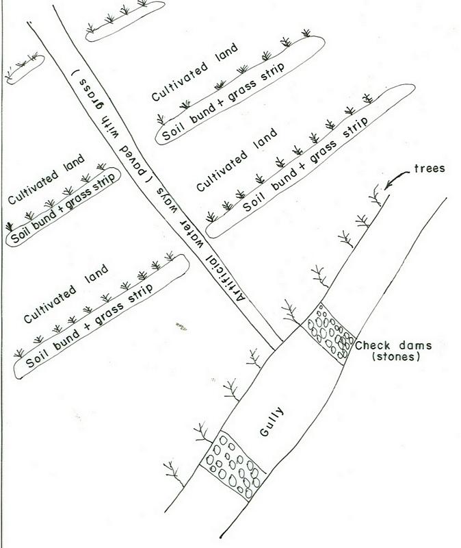
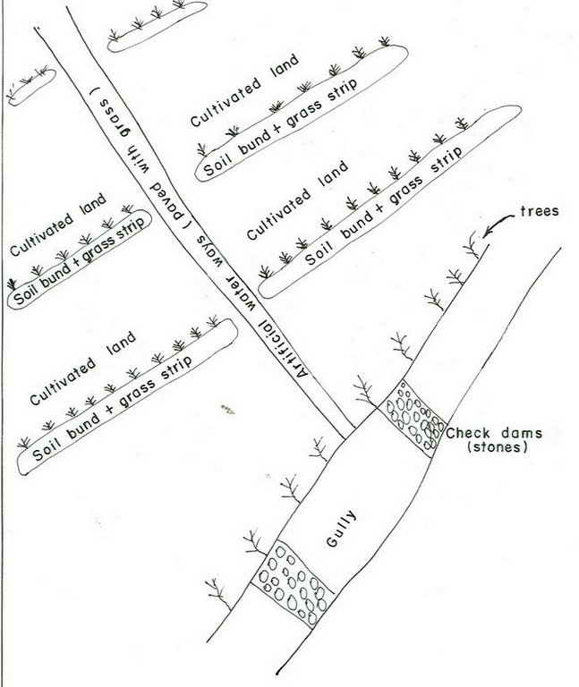
It is a structural measure with an embankment of soil or stones or soil and stones, constructed along the contour and stablized with vegetative measures (grass and fodder trees).
2.2 技术的详细说明
说明:
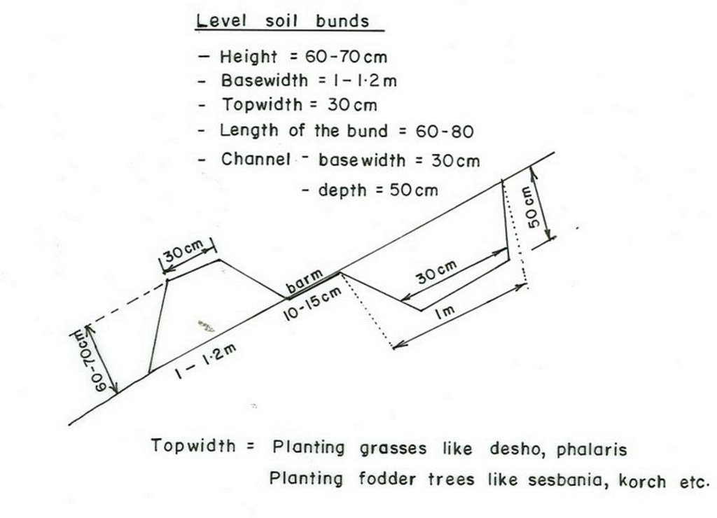
Applied on different land uses on slope of more than 3%. This practice is widely used by farmers in the area. Stone and stone faced bunds height depends on the availability of stones. On the average the width is 1-1.2m and hieght is 0.6-0.7m.
Purpose of the Technology: Bunds reduce the velocity of runoff and soil erosion, retains water behind the bund and let it infiltrate. It further helps in ground water recharging.
Establishment / maintenance activities and inputs: Planning is made by community/group and individual discussion and reach a consensus on layout, spacing, implementation modalities and management requirments is reached before implementation.
Natural / human environment: The technology is applicable in areas where soil is moderately deep and stones are available
2.3 技术照片
2.5 已应用该技术的、本评估所涵盖的国家/地区/地点
国家:
埃塞俄比亚
区域/州/省:
SNNPR/Hadiya/Lemo
有关地点的进一步说明:
Lemo
注释:
Total area covered by the SLM Technology is 173 km2.
Nowadays communities have developed positive attitudes towards SWC technologies implemented and the results obtained by practicing measures, which have reduced runoff and soil erosion reduced and land increased productivity.
Map
×2.6 实施日期
如果不知道确切的年份,请说明大概的日期:
- 50多年前(传统)
2.7 技术介绍
详细说明该技术是如何引入的:
- 通过项目/外部干预
注释(项目类型等):
Other countries and also other woredas in the country.
3. SLM技术的分类
3.2 应用该技术的当前土地利用类型

农田
- 一年一作
- 多年一作(非木材)
- 乔木与灌木的种植
年作 - 具体指明作物:
- 谷物类 - 玉米
- 谷类 - 其他
- 谷类 - 高粱
- 豆科牧草和豆类 - 其他
- 根/块茎作物 - 土豆
- 蔬菜 - 叶菜(色拉、卷心菜、菠菜和其他)
- wheat, haricot beans
多年生(非木质)作物 - 指定作物:
- 甘蔗
- Enset, Desho, Phalaris
乔木和灌木种植 - 指定作物:
- 鳄梨
- 咖啡,露天种植
- 芒果、山竹果、番石榴
- 木瓜
- Cordia, Croton, Ficus, Casmir
每年的生长季节数:
- 2
具体说明:
Longest growing period in days: 180 Longest growing period from month to month: Apr - Nov Second longest growing period in days: 150
采用间作制度了吗?:
是
如果是,说明哪些作物是间作的:
maize + haricot beans
coffee + cabbage

森林/林地
- 植树造林
产品和服务:
- 木材
- 薪材
- 放牧/啃牧
注释:
Major land use problems (compiler’s opinion): Absence of land use policy, low level of awarness, shortage of farm lands.
Major land use problems (land users’ perception): Continous cultivation, poor soil fertility, poverty, shortage of cultivated lands.
Plantation forestry: Yes
Problems / comments regarding forest use: Many peasant kebeles have earned money by selling eucalyptus grown on plantation areas of the community. Some have built schools from the proceeds. Some kebeles have shared sizable money from the sales of trees.
Type of cropping system and major crops comments: Cereals - legumes - cereals
3.3 由于技术的实施,土地使用是否发生了变化?
同一土地单元内混合使用的土地::
是

牧场
集约放牧/饲料生产:
- 收割和携带/零放牧
3.4 供水
该技术所应用土地的供水:
- 雨养
3.5 该技术所属的SLM组
- 横坡措施
3.6 包含该技术的可持续土地管理措施

农艺措施
- A2:有机质/土壤肥力
- A3:土壤表面处理
注释:
Main measures: structural measures
Secondary measures: agronomic measures, vegetative measures, management measures
Type of agronomic measures: early planting, mixed cropping / intercropping, legume inter-planting, manure / compost / residues, breaking compacted topsoil, contour tillage
Type of vegetative measures: aligned: -contour, scattered / dispersed
3.7 该技术强调的主要土地退化类型

土壤水蚀
- Wt:表土流失/地表侵蚀
- Wg:冲沟侵蚀/沟蚀

化学性土壤退化
- Cn:肥力下降和有机质含量下降(非侵蚀所致)
注释:
Main type of degradation addressed: Wt: loss of topsoil / surface erosion
Secondary types of degradation addressed: Wg: gully erosion / gullying, Cn: fertility decline and reduced organic matter content
3.8 防止、减少或恢复土地退化
具体数量名该技术与土地退化有关的目标:
- 防止土地退化
- 减少土地退化
注释:
Secondary goals: Rehabilitation / reclamation of denuded land
4. 技术规范、实施活动、投入和成本
4.1 该技术的技术图纸
技术规范(与技术图纸相关):
SNNPR
Technical knowledge required for field staff / advisors: high
Technical knowledge required for land users: moderate
Main technical functions: control of dispersed runoff: retain / trap, control of dispersed runoff: impede / retard, increase of infiltration
Secondary technical functions: reduction of slope angle, reduction of slope length, increase / maintain water stored in soil
Early planting
Material/ species: maize, potato
Remarks: row and broad casting
Mixed cropping / intercropping
Material/ species: sorghum + haricot beans
Remarks: row planting
Agronomic measure: mixed cropping / intercropping
Material/ species: maize + haricot beans
Remarks: row planting
Agronomic measure: mixed cropping / intercropping
Material/ species: coffee + cabbage
Remarks: row planting
Legume inter-planting
Remarks: row and broad casting
Manure / compost / residues
Material/ species: animal dung
Remarks: broad casting
Breaking compacted topsoil
Remarks: once, along the contour
Contour tillage
Remarks: 3-6 times, along the contour
Aligned: -contour
Vegetative material: G : grass
Vertical interval between rows / strips / blocks (m): 1m
Vertical interval within rows / strips / blocks (m): 0.3
Width within rows / strips / blocks (m): 1
Scattered / dispersed
Vegetative material: T : trees / shrubs
Number of plants per (ha): 10-15
Vegetative measure: scattered/dispersed
Vegetative material: F : fruit trees / shrubs
Number of plants per (ha): 40-60
Vegetative measure: Vegetative material: F : fruit trees / shrubs
Vegetative measure: Vegetative material: F : fruit trees / shrubs
Vegetative measure: Vegetative material: F : fruit trees / shrubs
Trees/ shrubs species: Cordia, Croton, Ficus
Fruit trees / shrubs species: Casmir, Avocado, Mango
Perennial crops species: Chat, Coffee, Sugar cane, Papaya
Grass species: Desho, Phalaris
Slope (which determines the spacing indicated above): 15.00%
If the original slope has changed as a result of the Technology, the slope today is (see figure below): 10.00%
Gradient along the rows / strips: 0.00%
Terrace: bench level
Vertical interval between structures (m): 1
Spacing between structures (m): 10
Depth of ditches/pits/dams (m): 0.5
Width of ditches/pits/dams (m): 0.3
Length of ditches/pits/dams (m): 1
Height of bunds/banks/others (m): 0.6-0.7
Width of bunds/banks/others (m): 1-1.2
Length of bunds/banks/others (m): 60-80
Construction material (earth): Soils excavated from the ditches is used to make the embankment.
Construction material (stone): Stones collected to construct stone/stone faced bunds.
Slope (which determines the spacing indicated above): 15%
If the original slope has changed as a result of the Technology, the slope today is: 10%
Lateral gradient along the structure: 0%
Vegetation is used for stabilisation of structures.
Change of land use type: cut and carry system practiced
Other type of management: change of management / intensity level - Follow up and evaluating the performance
4.2 有关投入和成本计算的一般信息
其它/国家货币(具体说明):
Birr
如相关,注明美元与当地货币的汇率(例如1美元=79.9巴西雷亚尔):1美元=:
8.6
注明雇用劳工的每日平均工资成本:
0.70
4.3 技术建立活动
| 活动 | 时间(季度) | |
|---|---|---|
| 1. | Production of planting materials | beginning of rains |
| 2. | Planting on the bund | during rains |
| 3. | Survey | dry season |
| 4. | Excavating the ditches and constructing the enbankment | dry season |
| 5. | desho grass transportation | during rains |
| 6. | Planting Desho grass on the bund | during rains |
| 7. | Group formation | dry season |
| 8. | Follow up and evaluating the activities | throughout the year |
4.4 技术建立所需要的费用和投入
| 对投入进行具体说明 | 单位 | 数量 | 单位成本 | 每项投入的总成本 | 土地使用者承担的成本% | |
|---|---|---|---|---|---|---|
| 劳动力 | Labour | ha | 1.0 | 156.0 | 156.0 | 5.0 |
| 设备 | Machine use | ha | 1.0 | 27.8 | 27.8 | |
| 设备 | Tools | ha | 1.0 | 32.1 | 32.1 | 70.0 |
| 植物材料 | Seeds | ha | 1.0 | 27.0 | 27.0 | 100.0 |
| 植物材料 | Seedlings | ha | 1.0 | 29.0 | 29.0 | 100.0 |
| 其它 | Grass | ha | 1.0 | 306.0 | 306.0 | 100.0 |
| 技术建立所需总成本 | 577.9 | |||||
| 技术建立总成本,美元 | 67.2 | |||||
注释:
Duration of establishment phase: 24 month(s)
4.5 维护/经常性活动
| 活动 | 时间/频率 | |
|---|---|---|
| 1. | Contour tillage | dry season / annual |
| 2. | Contour tillage | dry season / two to three times |
| 3. | Sawing | during rains / annual |
| 4. | Weeding | during rains / one or twice a year |
| 5. | Harvesting | dry season / annual |
| 6. | Replanting | during rains /once |
| 7. | Reconstruction | dry season/annual |
| 8. | Replanting | rainy season/annual |
4.6 维护/经常性活动所需要的费用和投入(每年)
| 对投入进行具体说明 | 单位 | 数量 | 单位成本 | 每项投入的总成本 | 土地使用者承担的成本% | |
|---|---|---|---|---|---|---|
| 劳动力 | Labour | ha | 1.0 | 18.84 | 18.84 | 100.0 |
| 设备 | Machine use | ha | 1.0 | 81.39 | 81.39 | 100.0 |
| 技术维护所需总成本 | 100.23 | |||||
| 技术维护总成本,美元 | 11.65 | |||||
注释:
Machinery/ tools: Shovel, hoe, water level, string
The cost is culculated per length of structure and other agricultural activities undertaken and the cost is in a hectare of land.
4.7 影响成本的最重要因素
描述影响成本的最决定性因素:
Type of hand tools, Slope of the land and soil depth.
5. 自然和人文环境
5.1 气候
年降雨量
- < 250毫米
- 251-500毫米
- 501-750毫米
- 751-1,000毫米
- 1,001-1,500毫米
- 1,501-2,000毫米
- 2,001-3,000毫米
- 3,001-4,000毫米
- > 4,000毫米
有关降雨的规范/注释:
1001-1500 mm (Ranked 1): 900-1400 mm, rains are tremendously variable.
751-1000 mm (Ranked 2): 900 mm, Parts of the SWC area receives on an average 900 mm.
农业气候带
- 半湿润
Very suitable to agricultural activities with variety crops grown.
5.2 地形
平均坡度:
- 水平(0-2%)
- 缓降(3-5%)
- 平缓(6-10%)
- 滚坡(11-15%)
- 崎岖(16-30%)
- 陡峭(31-60%)
- 非常陡峭(>60%)
地形:
- 高原/平原
- 山脊
- 山坡
- 山地斜坡
- 麓坡
- 谷底
垂直分布带:
- 0-100 m a.s.l.
- 101-500 m a.s.l.
- 501-1,000 m a.s.l.
- 1,001-1,500 m a.s.l.
- 1,501-2,000 m a.s.l.
- 2,001-2,500 m a.s.l.
- 2,501-3,000 m a.s.l.
- 3,001-4,000 m a.s.l.
- > 4,000 m a.s.l.
关于地形的注释和进一步规范:
Altitudinal zone: 2001-2500 m a.s.l. (Ranked 1, below 2400m asl, very suitable to wheat, barley and horse beans.) and 1501-2000 m a.s.l. (ranked 2, over 1900m asl, very suitable to cereal crops including maize)
Landforms: Hill slopes (ranked 1, dominant land forms with flatter village areas at the top) also, ridges (ranked 2) and plateau/plains (ranked 3)
Slopes on average: Rolling (Ranked 1, the technology is mostly implemented here), moderate (ranked 2, dominantly cultivated) and hilly (ranked 3, area enclosures) as well as gentle and steep (both ranked 3)
5.3 土壤
平均土层深度:
- 非常浅(0-20厘米)
- 浅(21-50厘米)
- 中等深度(51-80厘米)
- 深(81-120厘米)
- 非常深(> 120厘米)
土壤质地(表土):
- 中粒(壤土、粉土)
- 细粒/重质(粘土)
表土有机质:
- 中(1-3%)
- 低(<1%)
如有可能,附上完整的土壤描述或具体说明可用的信息,例如土壤类型、土壤酸碱度、阳离子交换能力、氮、盐度等。:
Soil depth on average: Also moderately deep (ranked 2, dominant soil depth in the SWC area) and shallow (ranked 3, degraded hillsides)
Soil texture: Fine/heavy (ranked 1, clay loam nitisols and vertisols) and medium (ranked 2, soils with high productivity)
Soil fertility: medium (ranked 1, most of the cereal cropped areas) and high (ranked 2, soils in the homestead)
Topsoil organic matter: Low (ranked 1, for all cereal cropped lands) and medium (ranked 2, land with perennial crops and homestead areas)
Soil drainage/infiltration: good (ranked 1, croplands on hillslopes ) and medium (ranked 2)
Soil water storage capacity: High (vertisols and soils on flat slopes)
5.6 应用该技术的土地使用者的特征
非农收入:
- 低于全部收入的10%
相对财富水平:
- 贫瘠
- 平均水平
机械化水平:
- 手工作业
- 畜力牵引
说明土地使用者的其他有关特征:
Population density: 200-500 persons/km2
Annual population growth: 2% - 3%
6% of the land users are rich and own 19% of the land.
35% of the land users are average wealthy and own 45% of the land.
45% of the land users are poor and own 15% of the land.
12% of the land users are poor and own 7% of the land.
Off-farm income specification: Land users who have SWC measures on their land have better income compared to others who do not have and they have better scope to get engaged in small trade.
Market orientation of production system: subsistence (cultivation and weeding of perennial crops done by hoe and weeding manual) and mixed (tillage is done by oxen)
5.7 应用该技术的土地使用者使用的平均土地面积
- < 0.5 公顷
- 0.5-1 公顷
- 1-2 公顷
- 2-5公顷
- 5-15公顷
- 15-50公顷
- 50-100公顷
- 100-500公顷
- 500-1,000公顷
- 1,000-10,000公顷
- > 10,000公顷
注释:
Most land users have 0.50-0.25 ha of land.
5.8 土地所有权、土地使用权和水使用权
土地所有权:
- 州
土地使用权:
- 个人
6. 影响和结论性说明
6.1 该技术的现场影响
社会经济效应
生产
作物生产
注释/具体说明:
soil loss reduced, fertilizers loss controlled
饲料生产
注释/具体说明:
bund stablization increased feed availability
饲料质量
注释/具体说明:
bund stablization increased feed availability
木材生产
注释/具体说明:
tree plantation
生产区域
注释/具体说明:
area occupied by the bund
收入和成本
农业收入
注释/具体说明:
production per unit area increased
社会文化影响
社区机构
注释/具体说明:
SWC activities organized and planned by communities
国家机构
注释/具体说明:
government & NGOs involvement increased
SLM/土地退化知识
注释/具体说明:
more land users acquired knowledge on SWC
生态影响
水循环/径流
多余水的排放
土壤
土壤水分
土壤覆盖层
注释/具体说明:
uphills planted with forest trees
土壤流失
SLM之前的数量:
82
SLM之后的数量:
8
注释/具体说明:
integrated measures
6.4 成本效益分析
技术收益与技术建立成本相比如何(从土地使用者的角度看)?
短期回报:
稍微积极
长期回报:
积极
技术收益与技术维护成本/经常性成本相比如何(从土地使用者的角度看)?
短期回报:
稍微积极
长期回报:
积极
6.5 技术采用
在所有采用这项技术的人当中,有多少人是自发的,即未获得任何物质奖励/付款?:
- 0-10%
注释:
10% of land user families have adopted the Technology with external material support
25600 land user families have adopted the Technology with external material support
Comments on acceptance with external material support: estimates
5% of land user families have adopted the Technology without any external material support
Comments on spontaneous adoption: estimates
There is a moderate trend towards spontaneous adoption of the Technology
Comments on adoption trend: Farmers have acquired some technical skills that enables them implement SWC measures by themselves on their own land with little external support.
6.7 该技术的优点/长处/机会
| 土地使用者眼中的长处/优势/机会 |
|---|
|
increased crop production How can they be sustained / enhanced? use high yielding varities and better farming systems. |
| soil erosion reduced |
| 编制者或其他关键资源人员认为的长处/优势/机会 |
|---|
|
soils protected from erosion How can they be sustained / enhanced? more awarness creation and strengthening maintenance |
|
sources of income diversified How can they be sustained / enhanced? introduce more productive multipurposive activities |
7. 参考和链接
7.1 信息的方法/来源
链接和模块
全部展开 全部收起链接
无链接
模块
无模块


