Earth embankment dams [马里]
- 创建:
- 更新:
- 编制者: Nina Lauterburg
- 编辑者: –
- 审查者: Deborah Niggli, Alexandra Gavilano
Barrages avec digues en terre (French)
technologies_1631 - 马里
查看章节
全部展开 全部收起1. 一般信息
1.2 参与该技术评估和文件编制的资源人员和机构的联系方式
SLM专业人员:
Dembele Célestin
Helvetas Swiss Intercooperation
马里
SLM专业人员:
Doumbia Moussa
ADEPE MALI
马里
有助于对技术进行记录/评估的项目名称(如相关)
Manual of Good Practices in Small Scale Irrigation in the Sahel (GIZ )有助于对技术进行记录/评估的机构名称(如相关)
Deutsche Gesellschaft für Internationale Zusammenarbeit (GIZ) - 德国1.3 关于使用通过WOCAT记录的数据的条件
编制者和关键资源人员接受有关使用通过WOCAT记录数据的条件。:
是
1.4 所述技术的可持续性声明
这里所描述的技术在土地退化方面是否存在问题,导致无法被认为是一种可持续的土地管理技术?:
否
2. SLM技术的说明
2.1 技术简介
技术定义:
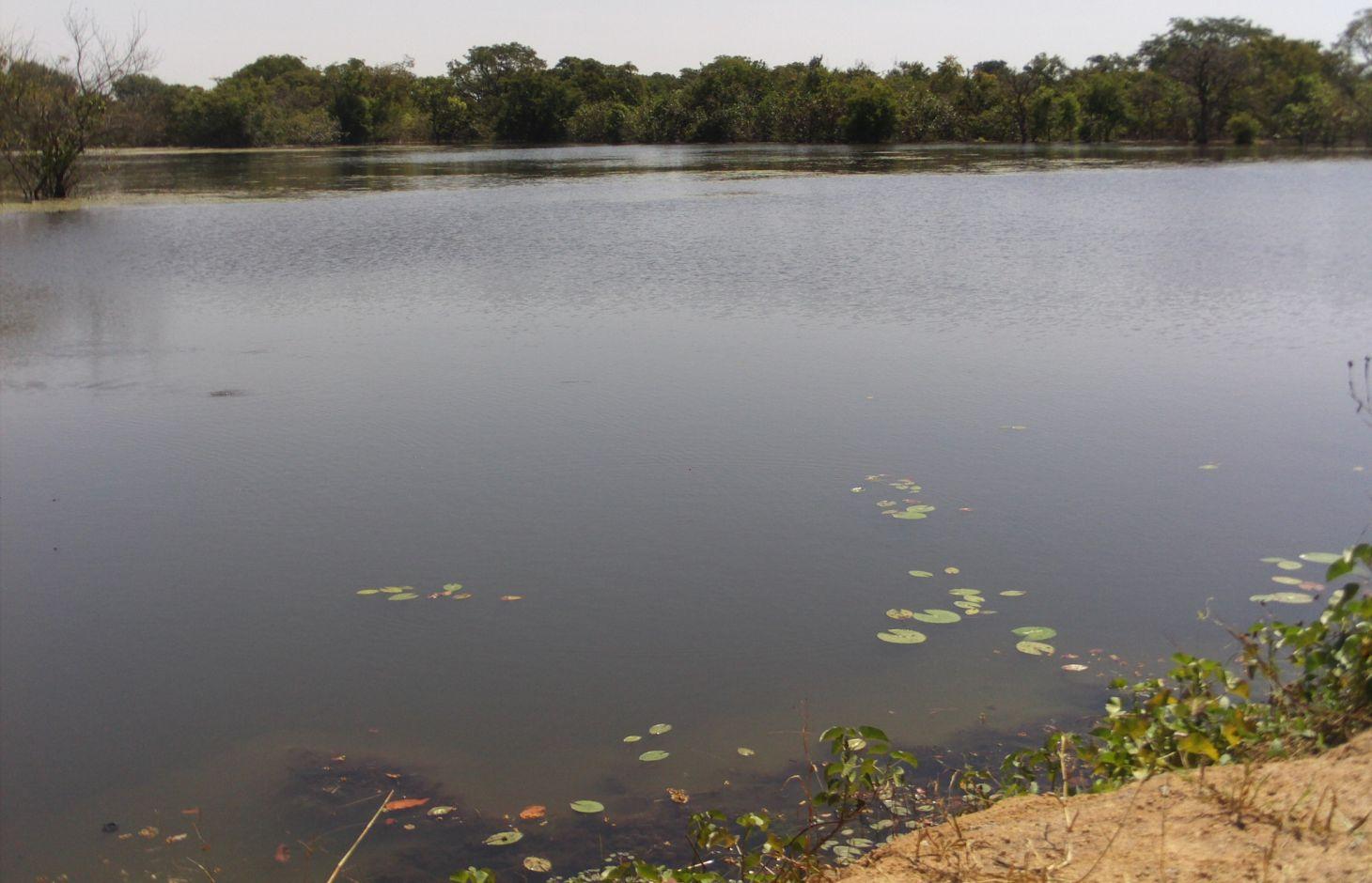
Embankment dams are built to retain rainwater without totally blocking the flow of water, enabling the irrigation of a part of the plain.
2.2 技术的详细说明
说明:
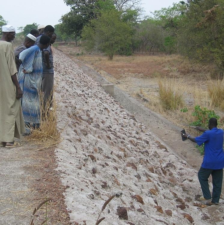
The installation of earth embankment dams in lowland areas comprises the following elements: 1) a compacted earth embankment, 100 to 450 metres in length; 2) a side spillway built with rubble or cyclopean concrete, 40 to 75 metres in length and connected to the embankment with lock walls; 3) a spillway stilling basin of loose stones; 4) dam height of up to five metres and a crest width of up to four metres; 5) a pond upstream of the embankment dug up to three to four metres deep for storing water throughout the dry season and, thereby, ensuring supplies for watering animals, market gardening and fish farming.
Embankment dams retain water in the basin for several months after the end of the rainy season, which can be used for watering livestock and crops off season; and they help raise the water table, which makes well water more easily accessible (at a depth of one to five metres). These dams are used for both controlled and free submersion.
The side of the embankment is about one metre higher than that of the side spillway. When the water level reaches the height of the side spillway, water flows down through the structure and continues along the riverbed on its normal route downstream. In-season rice growing is carried out both upstream and downstream of the dam. Upstream growers farming areas peripheral to the reservoir are advised to use varieties of floating rice or those that can withstand prolonged flooding. The seedlings for this kind of rice must be sown before the reservoir fills with water.
At the end of the growing season, the water is retained in the reservoir for watering animals and for fishing. Market gardening activities are carried out along the entire length of the river, with water being extracted from dug wells (sumps two to six metres deep).
In Mali, there are around 15 schemes in place in the circles of Sikasso, Kadiolo, Bougouni and Yanfolila, covering more than 1,000 hectares and benefiting 1,500 rural families. In these areas, more than 60% of rice growers are women. More than 100,000 head of cattle are watered each year from the reservoirs. The very large quantity of stored water considerably increases the potential to use land for vegetable and tree growing.
Local people formulate the requirement and negotiate with the commune on the investment programme; they identify the rules of access and set up the farming cooperatives and management bodies. The commune plans investments and assumes overall control of the construction work, delegates management to users, and validates the farming rules and oversees their correct application. Consultancies carry out the socio-economic, environmental and technical studies (scheme design, plans, models), draw up the invitation to tender document and support the tender selection process, and monitor and inspect works. Technical services oversee the application of technical and environmental standards and participate in ensuring sound financial practices (collection, financial control, public service concessions). Contractors carry out the construction work. The project team provides training (planning, social engineering, studies involving farmers, etc.), advisory support (organisation of users, formulation and validation of rules, area development plan, plan to develop and exploit value chains, selection of suitable crop varieties, management delegation procedures, procedures for securing land titles, etc.) and co-financing.
The users are divided up into management and maintenance teams and their respective responsibilities are clearly defined prior to the interim and final acceptance of works.
This type of scheme is effective in areas with good rainfall levels and in lowland areas where the water table is not very low. It is important to select lowland areas with the potential to store a substantial volume of water (topographic basins). This type of scheme works best in southern areas of Mali with 1,100 to 1,200 millimetres of precipitation per year.
2.3 技术照片
媒体库
2.5 已应用该技术的、本评估所涵盖的国家/地区/地点
国家:
马里
区域/州/省:
Mali
有关地点的进一步说明:
Kadiolo, Sikasso, Bougouni, Yanfolila
具体说明该技术的分布:
- 均匀地分布在一个区域
如果技术均匀分布在一个区域,则指定覆盖的区域(单位为平方千米):
10.0
注释:
Total area covered by the SLM Technology is 10 km2.
In the Sikasso region; in 15 or so communes within the circles of Kadiolo, Sikasso, Bougouni and Yanfolila. Around 1,000 hectares.
2.6 实施日期
如果不知道确切的年份,请说明大概的日期:
- 10-50年前
2.7 技术介绍
详细说明该技术是如何引入的:
- 通过项目/外部干预
注释(项目类型等):
Since 2003, by HELVETAS Swiss Intercooperation
3. SLM技术的分类
3.1 该技术的主要目的
- 改良生产
- 减少、预防、恢复土地退化
3.2 应用该技术的当前土地利用类型
同一土地单元内混合使用的土地::
是
具体说明混合土地使用(作物/放牧/树木):
- 农牧业(包括农牧结合)

农田
- 一年一作
每年的生长季节数:
- 1
具体说明:
Longest growing period in days: 120, Longest growing period from month to month: August-November

牧场

水道、水体、湿地
- 池塘、大坝
注释:
Major land use problems (compiler’s opinion): aridification, loss of water
Livestock density: 1-10 LU /km2
3.4 供水
该技术所应用土地的供水:
- 混合雨水灌溉
3.5 该技术所属的SLM组
- 灌溉管理(包括供水、排水)
- 引水和排水
- 地表水管理(泉、河、湖、海)
3.6 包含该技术的可持续土地管理措施

结构措施
- S5:大坝、集水斗、水池
3.7 该技术强调的主要土地退化类型

生物性退化
- Bc:植被覆盖的减少

水质恶化
- Ha:干旱化
- Hs:地表水良变化
- Hg:地下水/含水层水位的变化
注释:
Main causes of degradation: over abstraction / excessive withdrawal of water (for irrigation, industry, etc.), droughts
3.8 防止、减少或恢复土地退化
具体数量名该技术与土地退化有关的目标:
- 减少土地退化
4. 技术规范、实施活动、投入和成本
4.1 该技术的技术图纸
技术规范(与技术图纸相关):
Technical knowledge required for field staff / advisors: high
Technical knowledge required for land users: low
Main technical functions: increase of groundwater level / recharge of groundwater, water harvesting / increase water supply
Secondary technical functions: increase of infiltration
Spillway
Length of ditches/pits/dams (m): 40-75
Dam/ pan/ pond
Depth of ditches/pits/dams (m): 3-4
Wall/ barrier
Depth of ditches/pits/dams (m): 5
Width of ditches/pits/dams (m): 4
Length of ditches/pits/dams (m): 100-450
Structural measure: spillway stilling basin of loose stones
4.2 有关投入和成本计算的一般信息
其它/国家货币(具体说明):
CFA Franc
如相关,注明美元与当地货币的汇率(例如1美元=79.9巴西雷亚尔):1美元=:
512.0
4.3 技术建立活动
| 活动 | 时间(季度) | |
|---|---|---|
| 1. | Local people formulate the requirement and negotiate with the commune on the investment programme; they identify the rules of access and set up the farming cooperatives and management bodies | |
| 2. | Contractors carry out the construction work |
4.5 维护/经常性活动
| 活动 | 时间/频率 | |
|---|---|---|
| 1. | maintenance of the dam |
4.7 影响成本的最重要因素
描述影响成本的最决定性因素:
The cost of a scheme stands at around 40 million CFA francs (77838 Dollars) for between 10 to 80 hectares (0.5 to 4 million CFA francs per hectare (972-7780 Dollars)).
5. 自然和人文环境
5.1 气候
年降雨量
- < 250毫米
- 251-500毫米
- 501-750毫米
- 751-1,000毫米
- 1,001-1,500毫米
- 1,501-2,000毫米
- 2,001-3,000毫米
- 3,001-4,000毫米
- > 4,000毫米
农业气候带
- 半干旱
Thermal climate class: tropics
5.2 地形
平均坡度:
- 水平(0-2%)
- 缓降(3-5%)
- 平缓(6-10%)
- 滚坡(11-15%)
- 崎岖(16-30%)
- 陡峭(31-60%)
- 非常陡峭(>60%)
地形:
- 高原/平原
- 山脊
- 山坡
- 山地斜坡
- 麓坡
- 谷底
垂直分布带:
- 0-100 m a.s.l.
- 101-500 m a.s.l.
- 501-1,000 m a.s.l.
- 1,001-1,500 m a.s.l.
- 1,501-2,000 m a.s.l.
- 2,001-2,500 m a.s.l.
- 2,501-3,000 m a.s.l.
- 3,001-4,000 m a.s.l.
- > 4,000 m a.s.l.
5.3 土壤
平均土层深度:
- 非常浅(0-20厘米)
- 浅(21-50厘米)
- 中等深度(51-80厘米)
- 深(81-120厘米)
- 非常深(> 120厘米)
土壤质地(表土):
- 中粒(壤土、粉土)
- 细粒/重质(粘土)
表土有机质:
- 中(1-3%)
- 低(<1%)
5.4 水资源可用性和质量
地下水位表:
5-50米
地表水的可用性:
中等
水质(未处理):
仅供农业使用(灌溉)
5.5 生物多样性
物种多样性:
- 中等
5.6 应用该技术的土地使用者的特征
生产系统的市场定位:
- 混合(生计/商业)
非农收入:
- 收入的10-50%
相对财富水平:
- 贫瘠
- 平均水平
机械化水平:
- 手工作业
性别:
- 男人
说明土地使用者的其他有关特征:
Population density: < 10 persons/km2
Annual population growth: 2% - 3%
10% of the land users are rich.
50% of the land users are average wealthy.
30% of the land users are poor.
10% of the land users are very poor.
5.7 应用该技术的土地使用者使用的平均土地面积
- < 0.5 公顷
- 0.5-1 公顷
- 1-2 公顷
- 2-5公顷
- 5-15公顷
- 15-50公顷
- 50-100公顷
- 100-500公顷
- 500-1,000公顷
- 1,000-10,000公顷
- > 10,000公顷
这被认为是小规模、中规模还是大规模的(参照当地实际情况)?:
- 小规模的
5.8 土地所有权、土地使用权和水使用权
注释:
The irrigated land is allocated by the chief
5.9 进入服务和基础设施的通道
健康:
- 贫瘠
- 适度的
- 好
教育:
- 贫瘠
- 适度的
- 好
技术援助:
- 贫瘠
- 适度的
- 好
就业(例如非农):
- 贫瘠
- 适度的
- 好
市场:
- 贫瘠
- 适度的
- 好
能源:
- 贫瘠
- 适度的
- 好
道路和交通:
- 贫瘠
- 适度的
- 好
饮用水和卫生设施:
- 贫瘠
- 适度的
- 好
金融服务:
- 贫瘠
- 适度的
- 好
6. 影响和结论性说明
6.1 该技术的现场影响
社会经济效应
生产
作物生产
畜牧生产
生产故障风险
生产区域
收入和成本
农业收入
社会文化影响
食品安全/自给自足
冲突缓解
contribution to human well-being
注释/具体说明:
In Mali, there are around 15 schemes in place in the circles of Sikasso, Kadiolo, Bougouni and Yanfolila, covering more than 1,000 hectares and benefiting 1,500 rural families. In these areas, more than 60% of rice growers are women. More than 100,000 head of cattle are watered each year from the reservoirs. The very large quantity of stored water considerably increases the potential to use land for vegetable and tree growing.
生态影响
水循环/径流
水的回收/收集
地下水位/含水层
6.2 该技术的场外影响已经显现
旱季稳定可靠的水流
下游洪水
风力搬运沉积物
6.3 技术对渐变气候以及与气候相关的极端情况/灾害的暴露和敏感性(土地使用者认为的极端情况/灾害)
渐变气候
渐变气候
| 季节 | 增加或减少 | 该技术是如何应对的? | |
|---|---|---|---|
| 年温度 | 增加 | 好 |
气候有关的极端情况(灾害)
气象灾害
| 该技术是如何应对的? | |
|---|---|
| 局地暴雨 | 好 |
| 局地风暴 | 好 |
气候灾害
| 该技术是如何应对的? | |
|---|---|
| 干旱 | 好 |
水文灾害
| 该技术是如何应对的? | |
|---|---|
| 比较和缓的(河道)洪水 | 好 |
其他气候相关的后果
其他气候相关的后果
| 该技术是如何应对的? | |
|---|---|
| 缩短生长期 | 好 |
6.4 成本效益分析
技术收益与技术建立成本相比如何(从土地使用者的角度看)?
短期回报:
积极
长期回报:
非常积极
技术收益与技术维护成本/经常性成本相比如何(从土地使用者的角度看)?
短期回报:
非常积极
长期回报:
非常积极
6.5 技术采用
注释:
There is a moderate trend towards spontaneous adoption of the Technology
In Mali, there are around 15 schemes in place in the circles of Sikasso, Kadiolo, Bougouni and Yanfolila, covering more than 1,000 hectares and benefiting 1,500 rural families. The technique has now been mastered by a number of local companies. No dam has failed in the last eight years.
The technology has also been successfully adopted in northern Côte d’Ivoire.
6.7 该技术的优点/长处/机会
| 土地使用者眼中的长处/优势/机会 |
|---|
| At the community level, larger revenues are being generated. |
| The works are not overly complex from a technical point of view and can be delivered at a reasonable cost. |
| 编制者或其他关键资源人员认为的长处/优势/机会 |
|---|
| The scheme has enabled irrigable areas to be rehabilitated and extended. agricultural intensification is possible year round, providing several harvests. Farming yields have doubled, or even tripled, due to the availability of water supplies and the technical support that continued up until the end of works. High-added-value vegetable crops have been produced. |
| The water table has risen and rises to the surface at times. The wells located in the lowland basin no longer dry up. |
| Watering livestock is not difficult and the pastures in the catchment basin are larger because of the dam. Grazing animals stay in the area longer and produce manure. Moreover, fees are collected for the watering of livestock. |
| Fish have returned, along with crocodiles; both having previously disappeared from these village areas. There has been a five-fold increase in the volume of fishing activities, catches and trade. |
| Greater levels of biodiversity and vegetation have been observed in the vicinity of schemes. |
6.8 技术的弱点/缺点/风险及其克服方法
| 编制者或其他关键资源人员认为的弱点/缺点/风险 | 如何克服它们? |
|---|---|
| Installation requires the use of bulldozers and compactors, equipment that is not always available from local companies. | It is essential for regulatory and arbitration mechanisms to provide support in these areas throughout the process. |
| The initial request for a scheme is sometimes drawn up by a specific group of users who may not take into account the full range of functions offered by the scheme: indigenous livestock rearing, transhumant livestock rearing, rice growing, tree growing, market gardening, fishing, brickmaking, etc. |
7. 参考和链接
7.1 信息的方法/来源
- 实地考察、实地调查
- 与土地使用者的访谈
(现场)数据是什么时候汇编的?:
01/07/2012
7.2 参考可用出版物
标题、作者、年份、ISBN:
Manual of Good Practices in Small Scale Irrigation in the Sahel. Experiences from Mali. Published by GIZ in 2014.
可以从哪里获得?成本如何?
http://star-www.giz.de/starweb/giz/pub/servlet.starweb
标题、作者、年份、ISBN:
Intercooperation, Sahel Delegation (2008): Les aménagements de bas-fonds dans le bassin cotonnier de Sikasso. Expérience du programme Jékasy. [Developing lowland areas in the Sikasso cotton-growing basin. The Jékasy programme’s experience.] Intercooperation, Sahel Delegation: Capitalisation des experiences du programme Jékasy en gestion des ressources naturelles et aménagements des bas-fonds. [Capitalising on the experiences of the Jékasy programme in managing natural resources and lowland schemes.] Rapport Collecte de données sur la valorisation des ouvrages réalisés dans le Pôle de Bougouni sur le financement APEL [Data collection report on developing the value of APEL-funded schemes carried out in the Bougouni Hub] – Bougouni, April 2013
链接和模块
全部展开 全部收起链接
无链接
模块
无模块