Grass or stubble in areas prone to flooding and erosion [挪威]
- 创建:
- 更新:
- 编制者: Dominika Krzeminska
- 编辑者: Lillian Øygarden
- 审查者: Rima Mekdaschi Studer, William Critchley
Gras (eller ingen jordarbeiding) på arealer utsatt for flom og erosjon
technologies_6170 - 挪威
查看章节
全部展开 全部收起1. 一般信息
1.2 参与该技术评估和文件编制的资源人员和机构的联系方式
SLM专业人员:
SLM专业人员:
有助于对技术进行记录/评估的项目名称(如相关)
OPtimal strategies to retAIN and re-use water and nutrients in small agricultural catchments across different soil-climatic regions in Europe (OPTAIN)1.3 关于使用通过WOCAT记录的数据的条件
编制者和关键资源人员接受有关使用通过WOCAT记录数据的条件。:
是
1.4 所述技术的可持续性声明
这里所描述的技术在土地退化方面是否存在问题,导致无法被认为是一种可持续的土地管理技术?:
否
1.5 参考关于SLM方法(使用WOCAT记录的SLM方法)的调查问卷

Regional Environmental program [挪威]
Regulations and financial grants for reduction of pollution and promotion of the cultural landscape.
- 编制者: Kamilla Skaalsveen
2. SLM技术的说明
2.1 技术简介
技术定义:
Establishment of grass - or retaining stubble - on arable land that is prone to erosion and flooding to reduce the risk of soil and nutrient losses.
2.2 技术的详细说明
说明:
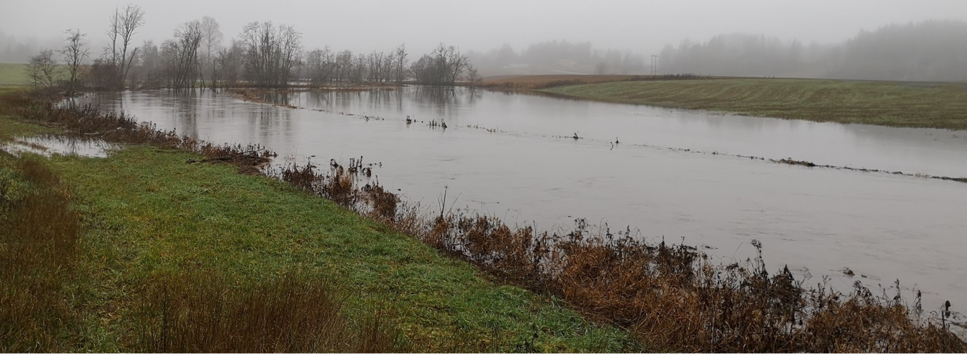
Flood prone areas are located close to watercourses (up to 22m from the watercourse) and are flooded regularly - at least once every ten years. If the area is considered as “flood prone” area must be assessed locally and approved at municipality or county level. Areas prone to erosion are the areas in the erosion class 2 (if there is a gully erosion), 3 and 4 (based on the erosion risk map; kilden.nibio.no).
Purpose/Aim: The main purpose of establishing grass cover (or at least maintaining stubble over winter) in the areas prone to erosion and flooding is to reduce soil erosion and nutrient losses. Grass cover protects the surface from detachment of particles and erosion processes. Grass covered areas enhance infiltration and provide good conditions for the uptake and storage of water during temporary floods. As such, the measure offers the potential for temporary flood storage, increased water retention in the landscape and runoff attenuation.
Perennial grass cover in the areas prone to flooding also protects water quality by enhanced sedimentation of suspended materials and increased adsorption of material to vegetation and soil surface.
Maintaining grass or stubble in areas prone to flooding and erosion is a subject for subsidies within Regional Environmental Programme RMP. The purpose of subsidies for is to reduced flood erosion. It includes both reducing soil erosion and preventing loss of nutrients.
Establishment/maintenance: vegetated zones or permanent meadows should be established and maintained within agricultural flood prone areas. As a minimum these areas should be left in stubble through the winter. These areas should not be fertilized, and grass should be harvested to reduce nutrient leakage to the watercourse. Where farmers persist in growing cereals in these areas they should at least leave the flood prone areas unploughed and covered in stubble over winter.
Benefit/Impact: The effect of (any) vegetation zones depends on several factors such as the flow properties and the characteristics of the vegetative surface. Studies of Norwegian conditions indicate that the most relevant factor for function of the vegetation zone is the character of the vegetation (height, robustness, and density), rather than the type of vegetation (Blankenberg & Hougsrud 2010). As the efficiency of vegetation is composed of a variety of factors, the implementation of the measures is to a large degree site specific (Kværnø & Stolte 2012). There is insufficient documentation on how the level of erosion is affected by floods. In Norway, there are no direct figures for the efficiency of grass cover on the areas prone to flooding.
Recent trends in climatic changes are expected to result in increase in extreme meteorological events and related natural hazards. The area along the streams and rivers are among the landscape elements, which first will notice the impact of climate change in the form of floods and consequent erosion. Therefore, measures dedicated to these areas might become more and more important.
Natural / human environment: The information about Technology is based on the investigations and/or reports from the Vansjø-Hobøl catchment. For the purpose of OPTAIN project (https://www.optain.eu/), the technology is further presented in the natural and human environment context of the Kråkstad River catchment - a Norwegian Case Study catchment within OPTAIN project.
The Kråkstad River is mainly situated in Ski municipality in South-Eastern parts of Norway. The river catchment is a western tributary of the Vansjø-Hobøl watercourse, also known as the Morsa watercourse. The Kråkstad River catchment area is c.a 51 km², 43% of which is agricultural land, where mostly cereals are produced on heavy clays soils. The main environmental challenge in the area is water quality (incl. high phosphorus pollution) and soil erosion (incl. riverbank erosion and quick-clay landslides).The Morsa watercourse is a drinking water resource and there are specific environmental regulations for land management followed by subsidies through the Regional Environmental Programme (RMP). Management of areas prone to flooding are part of these regulations.
2.3 技术照片
媒体库
2.5 已应用该技术的、本评估所涵盖的国家/地区/地点
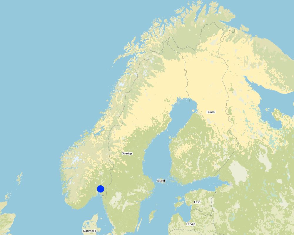
国家:
挪威
区域/州/省:
Viken county
有关地点的进一步说明:
The Vansjø-Hobøl catchment
具体说明该技术的分布:
- 适用于特定场所/集中在较小区域
技术现场是否位于永久保护区?:
否
Map
×2.6 实施日期
如果不知道确切的年份,请说明大概的日期:
- 10-50年前
2.7 技术介绍
详细说明该技术是如何引入的:
- 通过项目/外部干预
- Regional Environmental Programme (RMP).
注释(项目类型等):
Grass cover or stubble on the areas prone to flooding is a measure eligible for subsidies in Regional Environmental Programme (RMP).
3. SLM技术的分类
3.1 该技术的主要目的
- 减少、预防、恢复土地退化
- 结合其他技术保护流域/下游区域
- 适应气候变化/极端天气及其影响
3.2 应用该技术的当前土地利用类型
同一土地单元内混合使用的土地::
否

农田
- 一年一作
年作 - 具体指明作物:
- 谷类 - 其他
- small grains
每年的生长季节数:
- 1

森林/林地
- natural forest

水道、水体、湿地
- 排水管道、水道
3.3 由于技术的实施,土地使用是否发生了变化?
由于技术的实施,土地使用是否发生了变化?:
- 是(请在技术实施前填写以下有关土地利用的问题)
同一土地单元内混合使用的土地::
否
农田
- 一年一作
年作 - 具体指明作物:
- 谷类 - 其他
- small grains
采用间作制度了吗?:
否
采用轮作制度了吗?:
否
注释:
In cases where grass replaces cereals
3.4 供水
该技术所应用土地的供水:
- 雨养
3.5 该技术所属的SLM组
- 改良的地面/植被覆盖
- 地表水管理(泉、河、湖、海)
3.6 包含该技术的可持续土地管理措施

农艺措施
- A1:植被和土壤覆盖层

植物措施
- V2:草和多年生草本植物
- V3:植被的清理
3.7 该技术强调的主要土地退化类型

土壤水蚀
- Wt:表土流失/地表侵蚀
- Wg:冲沟侵蚀/沟蚀

水质恶化
- Hp:地表水水质下降
3.8 防止、减少或恢复土地退化
具体数量名该技术与土地退化有关的目标:
- 防止土地退化
- 减少土地退化
4. 技术规范、实施活动、投入和成本
4.1 该技术的技术图纸
技术规范(与技术图纸相关):
n.a.
4.2 有关投入和成本计算的一般信息
具体说明成本和投入是如何计算的:
- 每个技术区域
注明尺寸和面积单位:
daa of flood prone area
如果使用本地面积单位,注明转换系数为1公顷(例如1公顷=2.47英亩):1公顷=:
1 ha = 10 daa
其它/国家货币(具体说明):
NOK
如相关,注明美元与当地货币的汇率(例如1美元=79.9巴西雷亚尔):1美元=:
8.99
注明雇用劳工的每日平均工资成本:
c.a. 3000 NOK (it is only the cost of the time assuming 8h work per day, 320-500 NOK/hour/ person. Machinery, equipment, materials not included)
4.3 技术建立活动
| 活动 | 时间(季度) | |
|---|---|---|
| 1. | Plowing | |
| 2. | Harrowing | |
| 3. | Sowing grass | |
| 4. | Harvesting grass |
4.4 技术建立所需要的费用和投入
如果土地使用者负担的费用少于100%,请注明由谁负担其余费用:
Grass cover or stubble on the areas prone to flooding is a measure eligible for subsidies in Regional Environmental Programme (RMP)
注释:
The costs of establishment and management of grass cover on the areas prone to flooding are connected to sowing the area and reduced area for cereal production (in case of cereal production farm). The subsidies should be a compensation for such costs.
Within RMP for 2019-2022 the subside level for maintaining grass on areas prone of flooding is at the level of 210 kr/daa (c.a 233 USD/ha) in Viken region. For leaving such areas in stubble the subsidy level is 110 kr /daa (USD/ha) for areas with special regulations (drinking water quality) and 70 kr /daa (78 USD/ha) outside areas with special regulations.
4.5 维护/经常性活动
| 活动 | 时间/频率 | |
|---|---|---|
| 1. | Plowing | |
| 2. | Harrowing | |
| 3. | Sowing grass | |
| 4. | Harvesting grass |
4.6 维护/经常性活动所需要的费用和投入(每年)
如果土地使用者负担的费用少于100%,请注明由谁负担其余费用:
Grass cover or stubble on the areas prone to flooding is a measure eligible for subsidies in Regional Environmental Programme (RMP)
注释:
The costs of establishment and management of grass cover on the areas prone to flooding are connected to sowing the area and reduced area for cereal production (in case of cereal production farm). The subsidies should be a compensation for such costs.
Within RMP for 2019-2022 the subside level for maintaining grass on areas prone of flooding is at the level of 210 kr/daa (c.a 233 USD/ha) in Viken region. For leaving such areas in stubble the subsidy level is 110 kr /daa (USD/ha) for areas with special regulations (drinking water quality) and 70 kr /daa (78 USD/ha) outside areas with special regulations.
4.7 影响成本的最重要因素
描述影响成本的最决定性因素:
The costs of establishment and management of grass cover on the areas prone to flooding are not deviating for costs connected to regular crop land management. Therefore, implementation of grassed areas does not lead to any additional expenses for the land user.
The cost of the area management are depended on:
- area (daa) location and accessibility
- eligibility for subsidies in Regional Environmental Programme (RMP). For 2019-2022 the subside level for maintaining grass on areas prone of flooding is at the level of 210 kr/daa in Viken region- for areas with special regulations. For leaving such areas in stubble the subsidy level is 110 kr /daa for areas with special regulations (drinking water quality) and 70 kr /daa outside areas with special regulations.
5. 自然和人文环境
5.1 气候
年降雨量
- < 250毫米
- 251-500毫米
- 501-750毫米
- 751-1,000毫米
- 1,001-1,500毫米
- 1,501-2,000毫米
- 2,001-3,000毫米
- 3,001-4,000毫米
- > 4,000毫米
农业气候带
- 半湿润
- 半干旱
Thermal climate class: temperate
Thermal climate class: boreal
5.2 地形
平均坡度:
- 水平(0-2%)
- 缓降(3-5%)
- 平缓(6-10%)
- 滚坡(11-15%)
- 崎岖(16-30%)
- 陡峭(31-60%)
- 非常陡峭(>60%)
地形:
- 高原/平原
- 山脊
- 山坡
- 山地斜坡
- 麓坡
- 谷底
垂直分布带:
- 0-100 m a.s.l.
- 101-500 m a.s.l.
- 501-1,000 m a.s.l.
- 1,001-1,500 m a.s.l.
- 1,501-2,000 m a.s.l.
- 2,001-2,500 m a.s.l.
- 2,501-3,000 m a.s.l.
- 3,001-4,000 m a.s.l.
- > 4,000 m a.s.l.
5.3 土壤
平均土层深度:
- 非常浅(0-20厘米)
- 浅(21-50厘米)
- 中等深度(51-80厘米)
- 深(81-120厘米)
- 非常深(> 120厘米)
土壤质地(表土):
- 中粒(壤土、粉土)
- 细粒/重质(粘土)
土壤质地(地表以下> 20厘米):
- 中粒(壤土、粉土)
- 细粒/重质(粘土)
表土有机质:
- 中(1-3%)
如有可能,附上完整的土壤描述或具体说明可用的信息,例如土壤类型、土壤酸碱度、阳离子交换能力、氮、盐度等。:
Soil fertility is medium-high
Soil drainage/infiltration is poor, artificially drainage is needed
Soil water storage capacity is very low-low
5.4 水资源可用性和质量
地下水位表:
< 5米
地表水的可用性:
好
水质(未处理):
仅供农业使用(灌溉)
水质请参考::
地下水和地表水
水的盐度有问题吗?:
否
该区域正在发生洪水吗?:
是
5.5 生物多样性
物种多样性:
- 低
栖息地多样性:
- 低
5.6 应用该技术的土地使用者的特征
定栖或游牧:
- 定栖的
生产系统的市场定位:
- 混合(生计/商业)
- 商业/市场
非农收入:
- 收入的10-50%
- > 收入的50%
相对财富水平:
- 平均水平
- 丰富
个人或集体:
- 个人/家庭
机械化水平:
- 机械化/电动
性别:
- 女人
- 男人
土地使用者的年龄:
- 青年人
- 中年人
说明土地使用者的其他有关特征:
Land users applying the Technology are mainly common / average land users
Population density: < 10 persons/km2
Annual population growth: < 0.5%
10% of the land users are rich and own 10% of the land.
90% of the land users are average wealthy and own 90% of the land.
5.7 应用该技术的土地使用者使用的平均土地面积
- < 0.5 公顷
- 0.5-1 公顷
- 1-2 公顷
- 2-5公顷
- 5-15公顷
- 15-50公顷
- 50-100公顷
- 100-500公顷
- 500-1,000公顷
- 1,000-10,000公顷
- > 10,000公顷
这被认为是小规模、中规模还是大规模的(参照当地实际情况)?:
- 中等规模的
5.8 土地所有权、土地使用权和水使用权
土地所有权:
- 个人,有命名
土地使用权:
- 社区(有组织)
- 个人
用水权:
- 自由进入(无组织)
5.9 进入服务和基础设施的通道
健康:
- 贫瘠
- 适度的
- 好
教育:
- 贫瘠
- 适度的
- 好
技术援助:
- 贫瘠
- 适度的
- 好
就业(例如非农):
- 贫瘠
- 适度的
- 好
市场:
- 贫瘠
- 适度的
- 好
能源:
- 贫瘠
- 适度的
- 好
道路和交通:
- 贫瘠
- 适度的
- 好
饮用水和卫生设施:
- 贫瘠
- 适度的
- 好
金融服务:
- 贫瘠
- 适度的
- 好
6. 影响和结论性说明
6.1 该技术的现场影响
社会经济效应
生产
作物生产
注释/具体说明:
Crop production will be reduced if there is permanent grass cover. However, with frequent flooding events the area is not 100% productive anyway.
收入和成本
农业收入
注释/具体说明:
depending on subsidies or whether the grass are being harvested or not
工作量
注释/具体说明:
The costs of establishment and management of grass cover on the areas prone to flooding are not deviating for costs connected to regular crop land management
生态影响
水循环/径流
水质
地表径流
蒸发
土壤
土壤流失
土壤堆积
生物多样性:植被、动物
植被覆盖
注释/具体说明:
In the areas with permanent grass cover
6.2 该技术的场外影响已经显现
地下水/河流污染
注释/具体说明:
Minimum that is expected, not measures/monitored yet.
缓冲/过滤能力
注释/具体说明:
Minimum that is expected, not measures/monitored yet.
6.3 技术对渐变气候以及与气候相关的极端情况/灾害的暴露和敏感性(土地使用者认为的极端情况/灾害)
渐变气候
渐变气候
| 季节 | 增加或减少 | 该技术是如何应对的? | |
|---|---|---|---|
| 年温度 | 增加 | 好 | |
| 年降雨量 | 增加 | 好 |
气候有关的极端情况(灾害)
气象灾害
| 该技术是如何应对的? | |
|---|---|
| 局地暴雨 | 适度 |
水文灾害
| 该技术是如何应对的? | |
|---|---|
| 比较和缓的(河道)洪水 | 好 |
其他气候相关的后果
其他气候相关的后果
| 该技术是如何应对的? | |
|---|---|
| 缩短生长期 | 好 |
注释:
It is expected that climate change will:
- increase the growing season and not reduce the growing period - the technology will cope well with it.
- increase the frequency and intensity of flooding - the technology should cope well with it.
6.4 成本效益分析
技术收益与技术建立成本相比如何(从土地使用者的角度看)?
短期回报:
中性/平衡
长期回报:
中性/平衡
技术收益与技术维护成本/经常性成本相比如何(从土地使用者的角度看)?
短期回报:
中性/平衡
长期回报:
中性/平衡
注释:
The cost and income will depend on whether the farmer will harvest the grass covered area or not. If the area is not harvested it will reduce the area for production. The subsidies should partly compensate for costs.
6.5 技术采用
- 1-10%
在所有采用这项技术的人当中,有多少人是自发的,即未获得任何物质奖励/付款?:
- 0-10%
注释:
There is no trend towards spontaneous adoption of the Technology.
6.6 适应
最近是否对该技术进行了修改以适应不断变化的条件?:
否
6.7 该技术的优点/长处/机会
| 土地使用者眼中的长处/优势/机会 |
|---|
| Less soil erosion, less loss of nutrients , less work with removing soil erosion pattern |
| 编制者或其他关键资源人员认为的长处/优势/机会 |
|---|
| reduced soil erosion |
| reduced nutrient losses |
6.8 技术的弱点/缺点/风险及其克服方法
| 土地使用者认为的弱点/缺点/风险 | 如何克服它们? |
|---|---|
| land removed from crop production | |
| maintenance needed |
| 编制者或其他关键资源人员认为的弱点/缺点/风险 | 如何克服它们? |
|---|---|
| Not enough field based research about efficiency |
7. 参考和链接
7.1 信息的方法/来源
- 根据报告和其他现有文档进行编译
see the references
(现场)数据是什么时候汇编的?:
15/02/2022
7.2 参考可用出版物
标题、作者、年份、ISBN:
Blankenberg, A-G.B. and Skarbøvik E. 2019. Vegetasjon som miljøtiltak i jordbruket: Varianter, tilskudd og lovverk.NIBIO POP 5(10) 2019
可以从哪里获得?成本如何?
NIBIO website
标题、作者、年份、ISBN:
Kværnø S., Øygarden L., Bechmann M., Barneveld R. 2020. Tiltak mot erosjon på jordbruksareal. NIBIO POP 6(38)2020
可以从哪里获得?成本如何?
NIBIO website
7.3 链接到网络上的相关信息
标题/说明:
Blankenberg, A-G.B. and Skarbøvik E. 2019. Vegetasjon som miljøtiltak i jordbruket: Varianter, tilskudd og lovverk.NIBIO POP 5(10) 2019
URL:
https://nibio.brage.unit.no/nibio-xmlui/bitstream/handle/11250/2590439/NIBIO_POP_2019_5_10.pdf?sequence=1&isAllowed=y
标题/说明:
Kværnø S., Øygarden L., Bechmann M., Barneveld R. 2020. Tiltak mot erosjon på jordbruksareal. NIBIO POP 6(38)2020
URL:
https://nibio.brage.unit.no/nibio-xmlui/bitstream/handle/11250/2723843/NIBIO_POP_2020_6_38.pdf?sequence=4&isAllowed=y
7.4 一般注释
no remarks
链接和模块
全部展开 全部收起链接
Regional Environmental program [挪威]
Regulations and financial grants for reduction of pollution and promotion of the cultural landscape.
- 编制者: Kamilla Skaalsveen
模块
无模块