Buffer strips and hedges around cropland [匈牙利]
- 创建:
- 更新:
- 编制者: Brigitta Szabó
- 编辑者: Piroska Kassai, Zoltan Toth
- 审查者: William Critchley, Rima Mekdaschi Studer
Erdős és bozótos védősávok
technologies_6203 - 匈牙利
查看章节
全部展开 全部收起1. 一般信息
1.2 参与该技术评估和文件编制的资源人员和机构的联系方式
有助于对技术进行记录/评估的项目名称(如相关)
OPtimal strategies to retAIN and re-use water and nutrients in small agricultural catchments across different soil-climatic regions in Europe (OPTAIN)有助于对技术进行记录/评估的机构名称(如相关)
Institute for Soil Sciences, Centre for Agricultural Research (ATK TAKI) - 匈牙利1.3 关于使用通过WOCAT记录的数据的条件
编制者和关键资源人员接受有关使用通过WOCAT记录数据的条件。:
是
1.4 所述技术的可持续性声明
这里所描述的技术在土地退化方面是否存在问题,导致无法被认为是一种可持续的土地管理技术?:
否
2. SLM技术的说明
2.1 技术简介
技术定义:
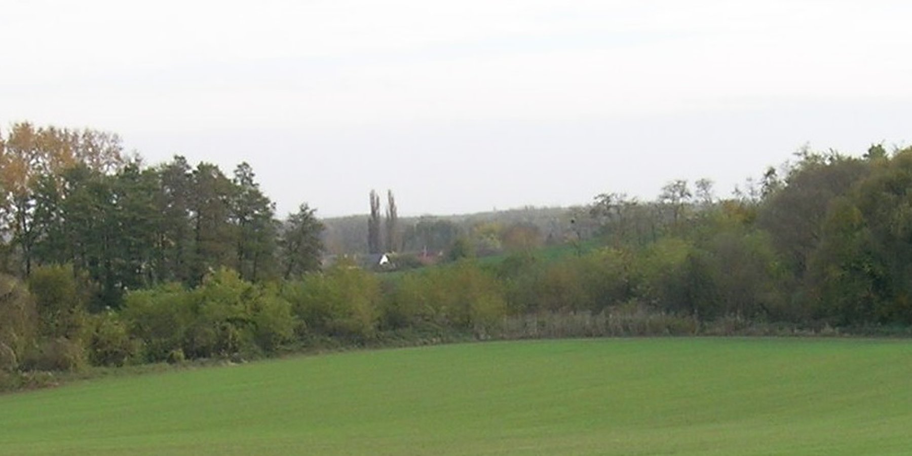
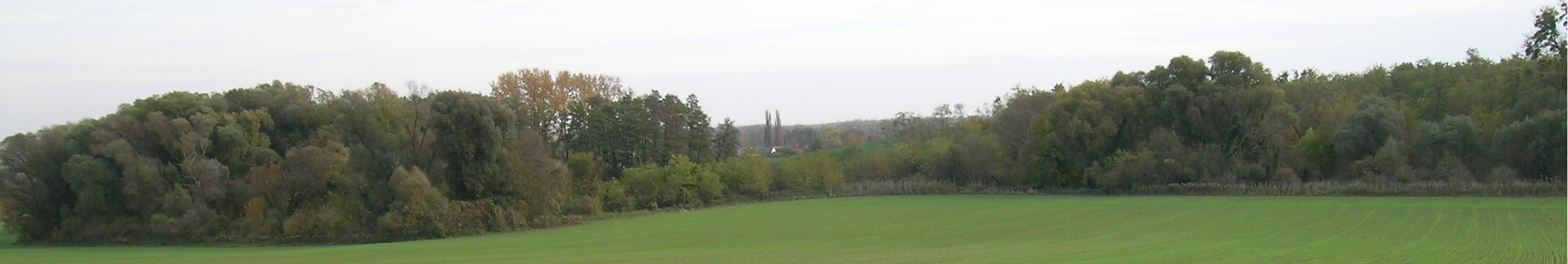
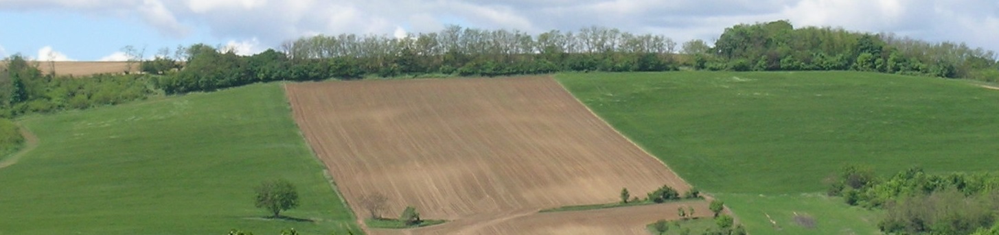
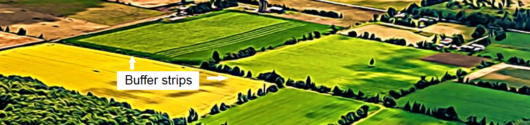
Buffer strips and hedges comprise natural vegetation of grass, bushes or trees. They are sited at the edges of fields, roads and surface water bodies. Their main function is to provide a natural buffer to control nutrient and sediment transport from agricultural fields by promoting water infiltration and slowing runoff, as well as preserving undisturbed green corridors.
2.2 技术的详细说明
说明:
Buffer strips and hedges comprise natural vegetation of grass, bushes and trees. They are sited at the edges of fields, roads and surface water bodies. Their main function is to provide a permanent natural buffer to intercept and control nutrient and sediment transport from agricultural fields, by slowing surface runoff and thus promoting infiltration. Creating such green corridors is ecologically advantageous as well.
Leaving field margins, headlands or strips around and between fields results in the natural germination and establishment of vegetation. Alternatively, buffer strips and hedges can be established deliberately according to a planting plan - which includes the species to be planted, their location and dimensions.
However, land users usually prefer to cultivate the possible largest areas, so they do not like leaving wide strips of “abandoned” land. In addition buffer strips and hedges provide habitats for wildlife – and this often results in damage to field crops by wild animals.
According to Hungarian forestry legislation, a strip of trees wider than 20 metres and larger than 0.5 hectare in total area is considered to be a forest, so in this case strict regulations have to be complied with. Below these threshold values land users have more liberty to do what they wish. When arable fields are close to, or surrounded by, afforested areas, conflict often arises between hunters and farmers, due to the damage caused by wild animals and hunters who cross farmers' fields – creating tracks and compacting the soil.
2.3 技术照片
媒体库
2.4 技术视频
注释、简短说明:
no video is available
2.5 已应用该技术的、本评估所涵盖的国家/地区/地点
国家:
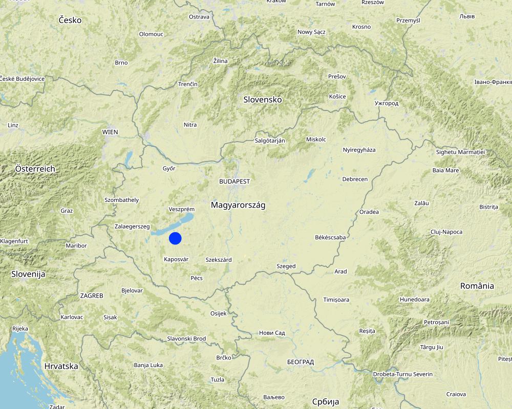
匈牙利
区域/州/省:
Somogy
有关地点的进一步说明:
The case study area is situated within the Balaton Catchment Area in the western Hungary. The climate is moderately warm, moderately humid, the number of sunshine hours per year are high. Mean annual temperature of the region of the Lake Balaton is about 10 ˚C. The average amount of rainfall (600-700 mm / year) nationally means a medium rainfall zone. The Balaton Catchment area is 5765 km2. The main environmental purpose is to reduce pollutant (phosphorus and other plant nutrients) loads of Lake Balaton, where anthropogenic eutrophication is the main issue of environmental concern. Lake Balaton, with its nearly 600 sqkm area, is the largest shallow lake in Middle Europe. The lake as well as the surrounding area form very important natural (ecological, water and landscape) resources and are one of the major target areas of water related recreational tourism in Europe as a whole. 37% of the total catchment area is arable land which is much lower than the national average, 27% is forest, which exceeds the national average. 15% of the land suitable for grassland management, 5% is horticulture, 3% is pomiculture, 2% is viticulture, 1% is reed management and fish farming. The „Kis-Balaton” nature conservation area situated within the Balaton Catchment area. The „Kis-Balaton” wetland is under protection of the Ramsar Convention habitat.
具体说明该技术的分布:
- 适用于特定场所/集中在较小区域
技术现场是否位于永久保护区?:
否
Map
×2.6 实施日期
如果不知道确切的年份,请说明大概的日期:
- 50多年前(传统)
2.7 技术介绍
详细说明该技术是如何引入的:
- 作为传统系统的一部分(> 50 年)
- 在实验/研究期间
3. SLM技术的分类
3.1 该技术的主要目的
- 减少、预防、恢复土地退化
- 保护生态系统
- 结合其他技术保护流域/下游区域
- 保持/提高生物多样性
- 降低灾害风险
3.2 应用该技术的当前土地利用类型
同一土地单元内混合使用的土地::
否

农田
- 一年一作
年作 - 具体指明作物:
- 谷物类 - 玉米
- 谷类 - 小麦(冬季)
- 油料作物 - 向日葵、菜籽、其他
每年的生长季节数:
- 1
采用间作制度了吗?:
是
如果是,说明哪些作物是间作的:
cover crop are grown between cash crops
采用轮作制度了吗?:
是
如果是,请具体说明:
oilseed rape - winter weet - maize - spring barley
3.3 由于技术的实施,土地使用是否发生了变化?
由于技术的实施,土地使用是否发生了变化?:
- 否(继续问题3.4)
同一土地单元内混合使用的土地::
否
3.4 供水
该技术所应用土地的供水:
- 雨养
3.5 该技术所属的SLM组
- 农业林学
- 防风林/防护林带
- 改良的地面/植被覆盖
- reducing runoff
3.6 包含该技术的可持续土地管理措施

植物措施
- V1:乔木和灌木覆盖层
3.7 该技术强调的主要土地退化类型

土壤水蚀
- Wt:表土流失/地表侵蚀
- Wg:冲沟侵蚀/沟蚀
3.8 防止、减少或恢复土地退化
具体数量名该技术与土地退化有关的目标:
- 防止土地退化
- 减少土地退化
4. 技术规范、实施活动、投入和成本
4.1 该技术的技术图纸
技术规范(与技术图纸相关):
Width of strips is max. 20 metres.
作者:
Piroska Kassai
日期:
13/03/2023
4.2 有关投入和成本计算的一般信息
具体说明成本和投入是如何计算的:
- 每个技术区域
注明尺寸和面积单位:
hectare = 20 m x 500 m
具体说明成本计算所用货币:
- 美元
注明雇用劳工的每日平均工资成本:
50
4.3 技术建立活动
| 活动 | 时间(季度) | |
|---|---|---|
| 1. | Soil preparation | autumn |
| 2. | Planting of trees or shrubs | autumn |
注释:
Buffers strips can be grass as well, but the calculation here is based on tree/shrub planting.
The calculation was done for one hectare but the contiguous buffer strips cannot exceed 0.5 hectare (and 20 m width).
4.4 技术建立所需要的费用和投入
| 对投入进行具体说明 | 单位 | 数量 | 单位成本 | 每项投入的总成本 | 土地使用者承担的成本% | |
|---|---|---|---|---|---|---|
| 劳动力 | Soil preparation | person day | 2.0 | 50.0 | 100.0 | 100.0 |
| 劳动力 | Planting | person day | 3.0 | 50.0 | 150.0 | 100.0 |
| 设备 | Soil preparation | hiring cost/day | 1.0 | 400.0 | 400.0 | 100.0 |
| 设备 | Planting | hiring cost/day | 1.0 | 100.0 | 100.0 | 100.0 |
| 植物材料 | Seedlings (for planting one hectare) | piece | 4000.0 | 0.1 | 400.0 | 100.0 |
| 技术建立所需总成本 | 1150.0 | |||||
| 技术建立总成本,美元 | 1150.0 | |||||
如果土地使用者负担的费用少于100%,请注明由谁负担其余费用:
The cost can be covered by agricultural subsidy (it will be available as targeted support under the new Common Agricultural Policy from 2023, but the exact amount has not yet been defined)
4.5 维护/经常性活动
| 活动 | 时间/频率 | |
|---|---|---|
| 1. | Pruning | yearly |
| 2. | Mechanical weeding | yearly |
4.6 维护/经常性活动所需要的费用和投入(每年)
| 对投入进行具体说明 | 单位 | 数量 | 单位成本 | 每项投入的总成本 | 土地使用者承担的成本% | |
|---|---|---|---|---|---|---|
| 劳动力 | Pruning | person-day | 1.0 | 50.0 | 50.0 | 100.0 |
| 劳动力 | Mechanical weeding | person-day | 1.0 | 50.0 | 50.0 | 100.0 |
| 设备 | Tillage/mechanical weeding machine | hiring cost/day | 1.0 | 200.0 | 200.0 | 100.0 |
| 技术维护所需总成本 | 300.0 | |||||
| 技术维护总成本,美元 | 300.0 | |||||
注释:
Conflicts often occur between farmers and hunters. There is a risk of damage of crops by wild animals.
4.7 影响成本的最重要因素
描述影响成本的最决定性因素:
Steep of the slope, soil texture, kind of wood species adapted to the area
5. 自然和人文环境
5.1 气候
年降雨量
- < 250毫米
- 251-500毫米
- 501-750毫米
- 751-1,000毫米
- 1,001-1,500毫米
- 1,501-2,000毫米
- 2,001-3,000毫米
- 3,001-4,000毫米
- > 4,000毫米
指定年平均降雨量(若已知),单位为mm:
653.00
有关降雨的规范/注释:
distribution is uneven
注明所考虑的参考气象站名称:
Keszthely meteorological station
农业气候带
- 半湿润
5.2 地形
平均坡度:
- 水平(0-2%)
- 缓降(3-5%)
- 平缓(6-10%)
- 滚坡(11-15%)
- 崎岖(16-30%)
- 陡峭(31-60%)
- 非常陡峭(>60%)
地形:
- 高原/平原
- 山脊
- 山坡
- 山地斜坡
- 麓坡
- 谷底
垂直分布带:
- 0-100 m a.s.l.
- 101-500 m a.s.l.
- 501-1,000 m a.s.l.
- 1,001-1,500 m a.s.l.
- 1,501-2,000 m a.s.l.
- 2,001-2,500 m a.s.l.
- 2,501-3,000 m a.s.l.
- 3,001-4,000 m a.s.l.
- > 4,000 m a.s.l.
说明该技术是否专门应用于:
- 不相关
5.3 土壤
平均土层深度:
- 非常浅(0-20厘米)
- 浅(21-50厘米)
- 中等深度(51-80厘米)
- 深(81-120厘米)
- 非常深(> 120厘米)
土壤质地(表土):
- 中粒(壤土、粉土)
土壤质地(地表以下> 20厘米):
- 中粒(壤土、粉土)
表土有机质:
- 中(1-3%)
5.4 水资源可用性和质量
地下水位表:
5-50米
地表水的可用性:
中等
水质(未处理):
不良饮用水(需要处理)
水质请参考::
地表水
水的盐度有问题吗?:
否
该区域正在发生洪水吗?:
是
5.5 生物多样性
物种多样性:
- 高
栖息地多样性:
- 高
5.6 应用该技术的土地使用者的特征
定栖或游牧:
- 定栖的
生产系统的市场定位:
- 商业/市场
非农收入:
- 低于全部收入的10%
相对财富水平:
- 平均水平
个人或集体:
- 个人/家庭
机械化水平:
- 机械化/电动
性别:
- 男人
土地使用者的年龄:
- 中年人
5.7 应用该技术的土地使用者使用的平均土地面积
- < 0.5 公顷
- 0.5-1 公顷
- 1-2 公顷
- 2-5公顷
- 5-15公顷
- 15-50公顷
- 50-100公顷
- 100-500公顷
- 500-1,000公顷
- 1,000-10,000公顷
- > 10,000公顷
这被认为是小规模、中规模还是大规模的(参照当地实际情况)?:
- 小规模的
5.8 土地所有权、土地使用权和水使用权
土地所有权:
- 个人,未命名
- 个人,有命名
土地使用权:
- 租赁
- 个人
用水权:
- 社区(有组织)
土地使用权是否基于传统的法律制度?:
是
5.9 进入服务和基础设施的通道
健康:
- 贫瘠
- 适度的
- 好
教育:
- 贫瘠
- 适度的
- 好
技术援助:
- 贫瘠
- 适度的
- 好
就业(例如非农):
- 贫瘠
- 适度的
- 好
市场:
- 贫瘠
- 适度的
- 好
能源:
- 贫瘠
- 适度的
- 好
道路和交通:
- 贫瘠
- 适度的
- 好
饮用水和卫生设施:
- 贫瘠
- 适度的
- 好
金融服务:
- 贫瘠
- 适度的
- 好
6. 影响和结论性说明
6.1 该技术的现场影响
社会经济效应
其它社会经济效应
maintaining soil fertility
社会文化影响
食品安全/自给自足
生态影响
水循环/径流
地表径流
注释/具体说明:
Vegetation within buffer strips slows the speed of runoff, allowing sediments to be deposited into the buffer strip area
蒸发
土壤
土壤流失
生物多样性:植被、动物
植被覆盖
动物多样性
注释/具体说明:
Vegetated margins around agricultural fields provide important refuge and food for invertebrates, mammals and birds
减少气候和灾害风险
碳和温室气体的排放
注释/具体说明:
Since the soil under vegetated strips is undisturbed carbon storage increases there.
火灾风险
注释/具体说明:
In drought conditions, the risk of fire increases significantly in dry scrub areas
风速
注释/具体说明:
Buffer strips have a wind-blocking effect if they are high enough
6.2 该技术的场外影响已经显现
下游洪水
地下水/河流污染
注释/具体说明:
Buffer strips are effective filters of the transported sediments, less soluble pesticides and fertilizers.
缓冲/过滤能力
对邻近农田的破坏
6.3 技术对渐变气候以及与气候相关的极端情况/灾害的暴露和敏感性(土地使用者认为的极端情况/灾害)
渐变气候
渐变气候
| 季节 | 增加或减少 | 该技术是如何应对的? | |
|---|---|---|---|
| 年降雨量 | 减少 | 适度 |
气候有关的极端情况(灾害)
气象灾害
| 该技术是如何应对的? | |
|---|---|
| 局地风暴 | 适度 |
气候灾害
| 该技术是如何应对的? | |
|---|---|
| 干旱 | 不好 |
| 森林火灾 | 非常不好 |
生物灾害
| 该技术是如何应对的? | |
|---|---|
| 昆虫/蠕虫侵扰 | 适度 |
6.4 成本效益分析
技术收益与技术建立成本相比如何(从土地使用者的角度看)?
短期回报:
消极
长期回报:
稍微积极
技术收益与技术维护成本/经常性成本相比如何(从土地使用者的角度看)?
短期回报:
消极
长期回报:
稍微积极
6.5 技术采用
- 1-10%
在所有采用这项技术的人当中,有多少人是自发的,即未获得任何物质奖励/付款?:
- 91-100%
6.6 适应
最近是否对该技术进行了修改以适应不断变化的条件?:
否
6.7 该技术的优点/长处/机会
| 土地使用者眼中的长处/优势/机会 |
|---|
| Reducing runoff, soil erosion |
| Improve water retention in large scale |
| Wind shade |
| 编制者或其他关键资源人员认为的长处/优势/机会 |
|---|
| Increase biodiversity, landscape and habitats |
6.8 技术的弱点/缺点/风险及其克服方法
| 土地使用者认为的弱点/缺点/风险 | 如何克服它们? |
|---|---|
| Support pest infestation | |
| Shading crop from sun radiation | |
| Evaporation of water around the strip | |
| Potential increase of yield damage caused by wild animals |
7. 参考和链接
7.1 信息的方法/来源
- 实地考察、实地调查
2
- 与土地使用者的访谈
3
- 与SLM专业人员/专家的访谈
1
(现场)数据是什么时候汇编的?:
15/10/2022
7.2 参考可用出版物
标题、作者、年份、ISBN:
Haddaway et al. 2018: The multifunctional roles of vegetated strips around and within agricultural fields
可以从哪里获得?成本如何?
https://environmentalevidencejournal.biomedcentral.com/articles/10.1186/s13750-018-0126-2
7.3 链接到网络上的相关信息
标题/说明:
EUROPEAN NWRM PLATFORM
URL:
nwrm.eu
7.4 一般注释
Usability of this documentation is limited for local farmers because of the language barrier.
链接和模块
全部展开 全部收起链接
无链接
模块
无模块