Buffer strips and hedges around cropland [Hungary]
- Creation:
- Update:
- Compiler: Brigitta Szabó
- Editors: Piroska Kassai, Zoltan Toth
- Reviewers: William Critchley, Rima Mekdaschi Studer
Erdős és bozótos védősávok
technologies_6203 - Hungary
View sections
Expand all Collapse all1. General information
1.2 Contact details of resource persons and institutions involved in the assessment and documentation of the Technology
Name of project which facilitated the documentation/ evaluation of the Technology (if relevant)
OPtimal strategies to retAIN and re-use water and nutrients in small agricultural catchments across different soil-climatic regions in Europe (OPTAIN) {'additional_translations': {}, 'value': 6270, 'label': 'Name of the institution(s) which facilitated the documentation/ evaluation of the Technology (if relevant)', 'text': 'Institute for Soil Sciences, Centre for Agricultural Research (ATK TAKI) - Hungary', 'template': 'raw'}1.3 Conditions regarding the use of data documented through WOCAT
The compiler and key resource person(s) accept the conditions regarding the use of data documented through WOCAT:
Yes
1.4 Declaration on sustainability of the described Technology
Is the Technology described here problematic with regard to land degradation, so that it cannot be declared a sustainable land management technology?
No
2. Description of the SLM Technology
2.1 Short description of the Technology
Definition of the Technology:
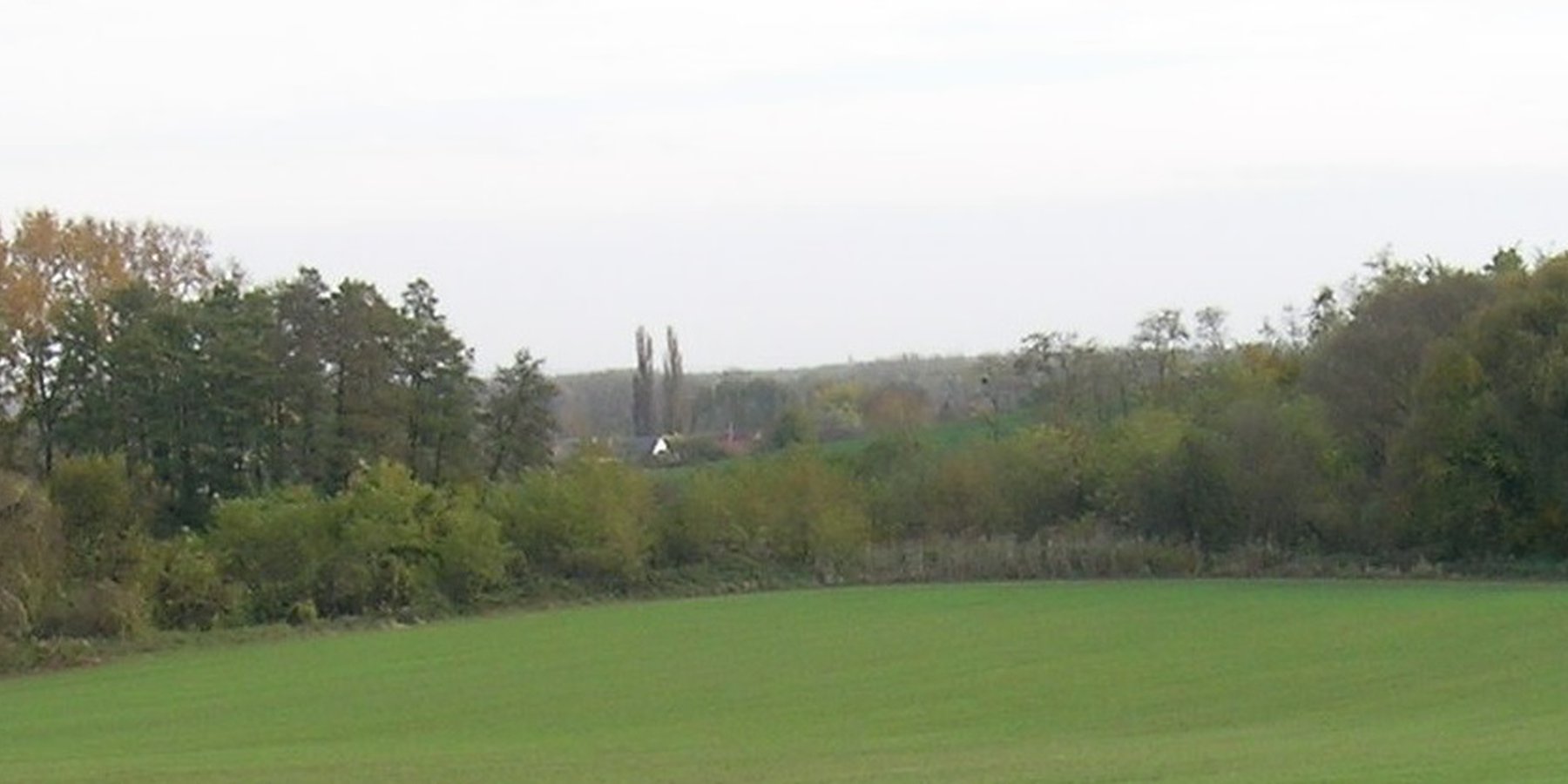
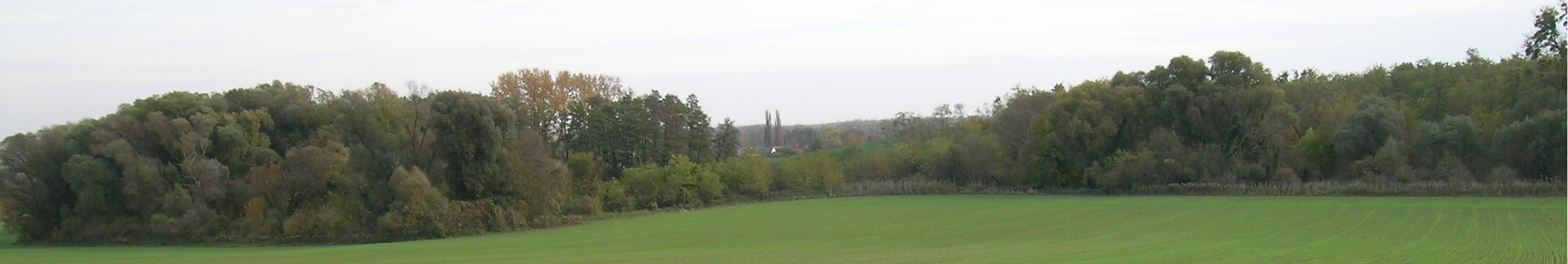
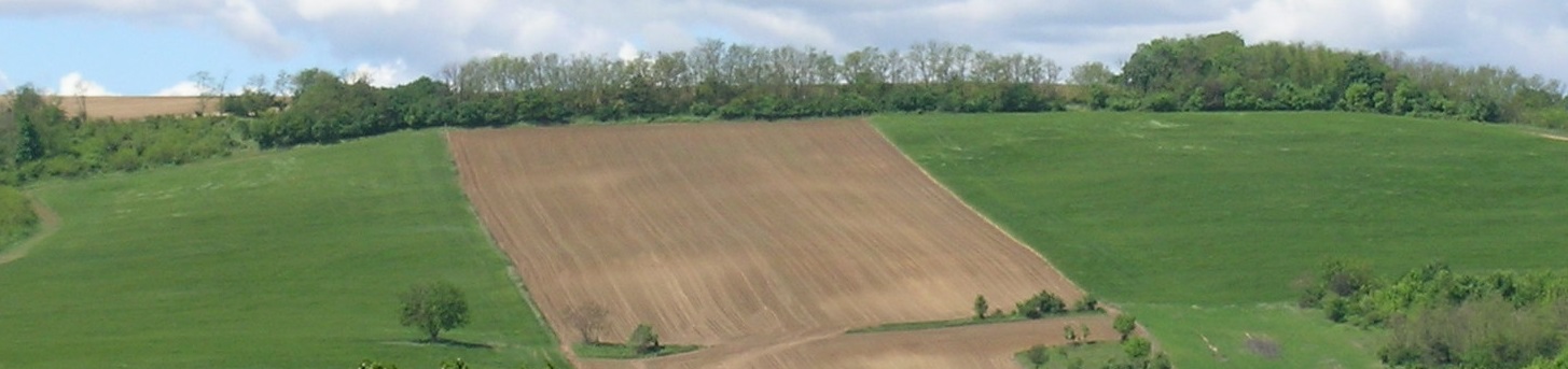
Buffer strips and hedges comprise natural vegetation of grass, bushes or trees. They are sited at the edges of fields, roads and surface water bodies. Their main function is to provide a natural buffer to control nutrient and sediment transport from agricultural fields by promoting water infiltration and slowing runoff, as well as preserving undisturbed green corridors.
2.2 Detailed description of the Technology
Description:
Buffer strips and hedges comprise natural vegetation of grass, bushes and trees. They are sited at the edges of fields, roads and surface water bodies. Their main function is to provide a permanent natural buffer to intercept and control nutrient and sediment transport from agricultural fields, by slowing surface runoff and thus promoting infiltration. Creating such green corridors is ecologically advantageous as well.
Leaving field margins, headlands or strips around and between fields results in the natural germination and establishment of vegetation. Alternatively, buffer strips and hedges can be established deliberately according to a planting plan - which includes the species to be planted, their location and dimensions.
However, land users usually prefer to cultivate the possible largest areas, so they do not like leaving wide strips of “abandoned” land. In addition buffer strips and hedges provide habitats for wildlife – and this often results in damage to field crops by wild animals.
According to Hungarian forestry legislation, a strip of trees wider than 20 metres and larger than 0.5 hectare in total area is considered to be a forest, so in this case strict regulations have to be complied with. Below these threshold values land users have more liberty to do what they wish. When arable fields are close to, or surrounded by, afforested areas, conflict often arises between hunters and farmers, due to the damage caused by wild animals and hunters who cross farmers' fields – creating tracks and compacting the soil.
2.3 Photos of the Technology
Media Gallery
2.4 Videos of the Technology
Comments, short description:
no video is available
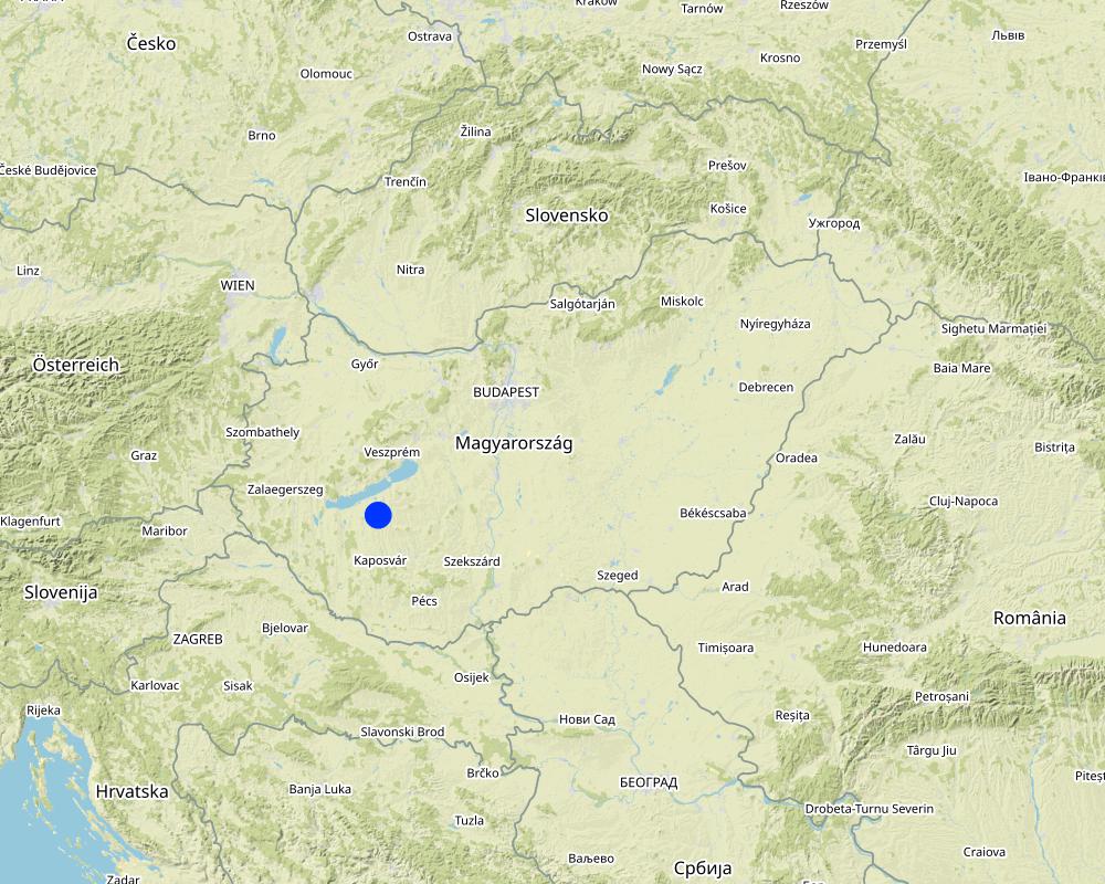
2.5 Country/ region/ locations where the Technology has been applied and which are covered by this assessment
Country:
Hungary
Region/ State/ Province:
Somogy
Further specification of location:
The case study area is situated within the Balaton Catchment Area in the western Hungary. The climate is moderately warm, moderately humid, the number of sunshine hours per year are high. Mean annual temperature of the region of the Lake Balaton is about 10 ˚C. The average amount of rainfall (600-700 mm / year) nationally means a medium rainfall zone. The Balaton Catchment area is 5765 km2. The main environmental purpose is to reduce pollutant (phosphorus and other plant nutrients) loads of Lake Balaton, where anthropogenic eutrophication is the main issue of environmental concern. Lake Balaton, with its nearly 600 sqkm area, is the largest shallow lake in Middle Europe. The lake as well as the surrounding area form very important natural (ecological, water and landscape) resources and are one of the major target areas of water related recreational tourism in Europe as a whole. 37% of the total catchment area is arable land which is much lower than the national average, 27% is forest, which exceeds the national average. 15% of the land suitable for grassland management, 5% is horticulture, 3% is pomiculture, 2% is viticulture, 1% is reed management and fish farming. The „Kis-Balaton” nature conservation area situated within the Balaton Catchment area. The „Kis-Balaton” wetland is under protection of the Ramsar Convention habitat.
Specify the spread of the Technology:
- applied at specific points/ concentrated on a small area
Is/are the technology site(s) located in a permanently protected area?
No
Map
×2.6 Date of implementation
If precise year is not known, indicate approximate date:
- more than 50 years ago (traditional)
2.7 Introduction of the Technology
Specify how the Technology was introduced:
- as part of a traditional system (> 50 years)
- during experiments/ research
3. Classification of the SLM Technology
3.1 Main purpose(s) of the Technology
- reduce, prevent, restore land degradation
- conserve ecosystem
- protect a watershed/ downstream areas – in combination with other Technologies
- preserve/ improve biodiversity
- reduce risk of disasters
3.2 Current land use type(s) where the Technology is applied
Land use mixed within the same land unit:
No

Cropland
- Annual cropping
Annual cropping - Specify crops:
- cereals - maize
- cereals - wheat (winter)
- oilseed crops - sunflower, rapeseed, other
Number of growing seasons per year:
- 1
Is intercropping practiced?
Yes
If yes, specify which crops are intercropped:
cover crop are grown between cash crops
Is crop rotation practiced?
Yes
If yes, specify:
oilseed rape - winter weet - maize - spring barley
3.3 Has land use changed due to the implementation of the Technology?
Has land use changed due to the implementation of the Technology?
- No (Continue with question 3.4)
Land use mixed within the same land unit:
No
3.4 Water supply
Water supply for the land on which the Technology is applied:
- rainfed
3.5 SLM group to which the Technology belongs
- agroforestry
- windbreak/ shelterbelt
- improved ground/ vegetation cover
- reducing runoff
3.6 SLM measures comprising the Technology

vegetative measures
- V1: Tree and shrub cover
3.7 Main types of land degradation addressed by the Technology

soil erosion by water
- Wt: loss of topsoil/ surface erosion
- Wg: gully erosion/ gullying
3.8 Prevention, reduction, or restoration of land degradation
Specify the goal of the Technology with regard to land degradation:
- prevent land degradation
- reduce land degradation
4. Technical specifications, implementation activities, inputs, and costs
4.1 Technical drawing of the Technology
Technical specifications (related to technical drawing):
Width of strips is max. 20 metres.
Author:
Piroska Kassai
Date:
13/03/2023
4.2 General information regarding the calculation of inputs and costs
Specify how costs and inputs were calculated:
- per Technology area
Indicate size and area unit:
hectare = 20 m x 500 m
Specify currency used for cost calculations:
- USD
Indicate average wage cost of hired labour per day:
50
4.3 Establishment activities
| Activity | Timing (season) | |
|---|---|---|
| 1. | Soil preparation | autumn |
| 2. | Planting of trees or shrubs | autumn |
Comments:
Buffers strips can be grass as well, but the calculation here is based on tree/shrub planting.
The calculation was done for one hectare but the contiguous buffer strips cannot exceed 0.5 hectare (and 20 m width).
4.4 Costs and inputs needed for establishment
| Specify input | Unit | Quantity | Costs per Unit | Total costs per input | % of costs borne by land users | |
|---|---|---|---|---|---|---|
| Labour | Soil preparation | person day | 2.0 | 50.0 | 100.0 | 100.0 |
| Labour | Planting | person day | 3.0 | 50.0 | 150.0 | 100.0 |
| Equipment | Soil preparation | hiring cost/day | 1.0 | 400.0 | 400.0 | 100.0 |
| Equipment | Planting | hiring cost/day | 1.0 | 100.0 | 100.0 | 100.0 |
| Plant material | Seedlings (for planting one hectare) | piece | 4000.0 | 0.1 | 400.0 | 100.0 |
| Total costs for establishment of the Technology | 1150.0 | |||||
| Total costs for establishment of the Technology in USD | 1150.0 | |||||
If land user bore less than 100% of costs, indicate who covered the remaining costs:
The cost can be covered by agricultural subsidy (it will be available as targeted support under the new Common Agricultural Policy from 2023, but the exact amount has not yet been defined)
4.5 Maintenance/ recurrent activities
| Activity | Timing/ frequency | |
|---|---|---|
| 1. | Pruning | yearly |
| 2. | Mechanical weeding | yearly |
4.6 Costs and inputs needed for maintenance/ recurrent activities (per year)
| Specify input | Unit | Quantity | Costs per Unit | Total costs per input | % of costs borne by land users | |
|---|---|---|---|---|---|---|
| Labour | Pruning | person-day | 1.0 | 50.0 | 50.0 | 100.0 |
| Labour | Mechanical weeding | person-day | 1.0 | 50.0 | 50.0 | 100.0 |
| Equipment | Tillage/mechanical weeding machine | hiring cost/day | 1.0 | 200.0 | 200.0 | 100.0 |
| Total costs for maintenance of the Technology | 300.0 | |||||
| Total costs for maintenance of the Technology in USD | 300.0 | |||||
Comments:
Conflicts often occur between farmers and hunters. There is a risk of damage of crops by wild animals.
4.7 Most important factors affecting the costs
Describe the most determinate factors affecting the costs:
Steep of the slope, soil texture, kind of wood species adapted to the area
5. Natural and human environment
5.1 Climate
Annual rainfall
- < 250 mm
- 251-500 mm
- 501-750 mm
- 751-1,000 mm
- 1,001-1,500 mm
- 1,501-2,000 mm
- 2,001-3,000 mm
- 3,001-4,000 mm
- > 4,000 mm
Specify average annual rainfall (if known), in mm:
653.00
Specifications/ comments on rainfall:
distribution is uneven
Indicate the name of the reference meteorological station considered:
Keszthely meteorological station
Agro-climatic zone
- sub-humid
5.2 Topography
Slopes on average:
- flat (0-2%)
- gentle (3-5%)
- moderate (6-10%)
- rolling (11-15%)
- hilly (16-30%)
- steep (31-60%)
- very steep (>60%)
Landforms:
- plateau/plains
- ridges
- mountain slopes
- hill slopes
- footslopes
- valley floors
Altitudinal zone:
- 0-100 m a.s.l.
- 101-500 m a.s.l.
- 501-1,000 m a.s.l.
- 1,001-1,500 m a.s.l.
- 1,501-2,000 m a.s.l.
- 2,001-2,500 m a.s.l.
- 2,501-3,000 m a.s.l.
- 3,001-4,000 m a.s.l.
- > 4,000 m a.s.l.
Indicate if the Technology is specifically applied in:
- not relevant
5.3 Soils
Soil depth on average:
- very shallow (0-20 cm)
- shallow (21-50 cm)
- moderately deep (51-80 cm)
- deep (81-120 cm)
- very deep (> 120 cm)
Soil texture (topsoil):
- medium (loamy, silty)
Soil texture (> 20 cm below surface):
- medium (loamy, silty)
Topsoil organic matter:
- medium (1-3%)
5.4 Water availability and quality
Ground water table:
5-50 m
Availability of surface water:
medium
Water quality (untreated):
poor drinking water (treatment required)
Water quality refers to:
surface water
Is water salinity a problem?
No
Is flooding of the area occurring?
Yes
5.5 Biodiversity
Species diversity:
- high
Habitat diversity:
- high
5.6 Characteristics of land users applying the Technology
Sedentary or nomadic:
- Sedentary
Market orientation of production system:
- commercial/ market
Off-farm income:
- less than 10% of all income
Relative level of wealth:
- average
Individuals or groups:
- individual/ household
Level of mechanization:
- mechanized/ motorized
Gender:
- men
Age of land users:
- middle-aged
5.7 Average area of land used by land users applying the Technology
- < 0.5 ha
- 0.5-1 ha
- 1-2 ha
- 2-5 ha
- 5-15 ha
- 15-50 ha
- 50-100 ha
- 100-500 ha
- 500-1,000 ha
- 1,000-10,000 ha
- > 10,000 ha
Is this considered small-, medium- or large-scale (referring to local context)?
- small-scale
5.8 Land ownership, land use rights, and water use rights
Land ownership:
- individual, not titled
- individual, titled
Land use rights:
- leased
- individual
Water use rights:
- communal (organized)
Are land use rights based on a traditional legal system?
Yes
5.9 Access to services and infrastructure
health:
- poor
- moderate
- good
education:
- poor
- moderate
- good
technical assistance:
- poor
- moderate
- good
employment (e.g. off-farm):
- poor
- moderate
- good
markets:
- poor
- moderate
- good
energy:
- poor
- moderate
- good
roads and transport:
- poor
- moderate
- good
drinking water and sanitation:
- poor
- moderate
- good
financial services:
- poor
- moderate
- good
6. Impacts and concluding statements
6.1 On-site impacts the Technology has shown
Socio-economic impacts
Other socio-economic impacts
maintaining soil fertility
Socio-cultural impacts
food security/ self-sufficiency
Ecological impacts
Water cycle/ runoff
surface runoff
Comments/ specify:
Vegetation within buffer strips slows the speed of runoff, allowing sediments to be deposited into the buffer strip area
evaporation
Soil
soil loss
Biodiversity: vegetation, animals
Vegetation cover
animal diversity
Comments/ specify:
Vegetated margins around agricultural fields provide important refuge and food for invertebrates, mammals and birds
Climate and disaster risk reduction
emission of carbon and greenhouse gases
Comments/ specify:
Since the soil under vegetated strips is undisturbed carbon storage increases there.
fire risk
Comments/ specify:
In drought conditions, the risk of fire increases significantly in dry scrub areas
wind velocity
Comments/ specify:
Buffer strips have a wind-blocking effect if they are high enough
6.2 Off-site impacts the Technology has shown
downstream flooding
groundwater/ river pollution
Comments/ specify:
Buffer strips are effective filters of the transported sediments, less soluble pesticides and fertilizers.
buffering/ filtering capacity
damage on neighbours' fields
6.3 Exposure and sensitivity of the Technology to gradual climate change and climate-related extremes/ disasters (as perceived by land users)
Gradual climate change
Gradual climate change
| Season | increase or decrease | How does the Technology cope with it? | |
|---|---|---|---|
| annual rainfall | decrease | moderately |
Climate-related extremes (disasters)
Meteorological disasters
| How does the Technology cope with it? | |
|---|---|
| local windstorm | moderately |
Climatological disasters
| How does the Technology cope with it? | |
|---|---|
| drought | not well |
| forest fire | not well at all |
Biological disasters
| How does the Technology cope with it? | |
|---|---|
| insect/ worm infestation | moderately |
6.4 Cost-benefit analysis
How do the benefits compare with the establishment costs (from land users’ perspective)?
Short-term returns:
negative
Long-term returns:
slightly positive
How do the benefits compare with the maintenance/ recurrent costs (from land users' perspective)?
Short-term returns:
negative
Long-term returns:
slightly positive
6.5 Adoption of the Technology
- 1-10%
Of all those who have adopted the Technology, how many did so spontaneously, i.e. without receiving any material incentives/ payments?
- 91-100%
6.6 Adaptation
Has the Technology been modified recently to adapt to changing conditions?
No
6.7 Strengths/ advantages/ opportunities of the Technology
| Strengths/ advantages/ opportunities in the land user’s view |
|---|
| Reducing runoff, soil erosion |
| Improve water retention in large scale |
| Wind shade |
| Strengths/ advantages/ opportunities in the compiler’s or other key resource person’s view |
|---|
| Increase biodiversity, landscape and habitats |
6.8 Weaknesses/ disadvantages/ risks of the Technology and ways of overcoming them
| Weaknesses/ disadvantages/ risks in the land user’s view | How can they be overcome? |
|---|---|
| Support pest infestation | |
| Shading crop from sun radiation | |
| Evaporation of water around the strip | |
| Potential increase of yield damage caused by wild animals |
7. References and links
7.1 Methods/ sources of information
- field visits, field surveys
2
- interviews with land users
3
- interviews with SLM specialists/ experts
1
When were the data compiled (in the field)?
15/10/2022
7.2 References to available publications
Title, author, year, ISBN:
Haddaway et al. 2018: The multifunctional roles of vegetated strips around and within agricultural fields
Available from where? Costs?
https://environmentalevidencejournal.biomedcentral.com/articles/10.1186/s13750-018-0126-2
7.3 Links to relevant online information
Title/ description:
EUROPEAN NWRM PLATFORM
URL:
nwrm.eu
7.4 General comments
Usability of this documentation is limited for local farmers because of the language barrier.
Links and modules
Expand all Collapse allLinks
No links
Modules
No modules