Integrated land management in high landscape of small scale farm [Thailand]
- Creation:
- Update:
- Compiler: Pitayakon Limtong
- Editor: –
- Reviewers: Rima Mekdaschi Studer, William Critchley
Khok Nong Na Model (mound reservoir paddy model)
technologies_4115 - Thailand
View sections
Expand all Collapse all1. معلومات عامة
1.2 Contact details of resource persons and institutions involved in the assessment and documentation of the Technology
Key resource person(s)
SLM specialist:
Lertditsayawan เลิศดิษยวรรณ Ms.Somjit
668 9807 4024
ktb.somjit@gmail.com
Land Development Department
125/30 ซอยวัดดงมูลเหล็ก แขวงบ้านช่างหล่อ, บางกอกน้อย Bangkok 10700, Thailand
Thailand
SLM Consultant:
land user:
แหลมคม Mr.Boonma
ุุ668 5718 5067
village Headman
6/1 หมู่ที่1 ต.บ้านทับ, แม่แจ่ม เชียงใหม่ 50270
Thailand
land user:
Suwanno Mr.Teerasak
668 2887 8462
Assistant village Headman
6 หมู่ที่1 ต.บ้านทับ, แม่แจ่ม, เชียงใหม่ 50270
Thailand
1.3 Conditions regarding the use of data documented through WOCAT
When were the data compiled (in the field)?
12/09/2018
The compiler and key resource person(s) accept the conditions regarding the use of data documented through WOCAT:
نعم
1.4 Declaration on sustainability of the described Technology
Is the Technology described here problematic with regard to land degradation, so that it cannot be declared a sustainable land management technology?
لا
2. Description of the SLM Technology
2.1 Short description of the Technology
Definition of the Technology:
ระบบการจัดการน้ำบนพื้นที่สูงด้วยศาสตร์พระราชาร่วมกับภูมิปัญญาท้องถิ่น เป็นแนวทางปฏิบัติในพื้นที่สูง ใช้การ “เปลี่ยนเขาหัวโล้น เป็นเขาหัวจุก”
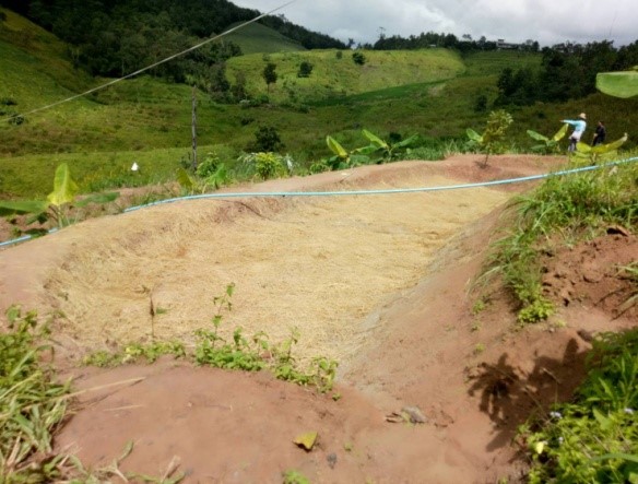
2.3 Photos of the Technology
Media Gallery

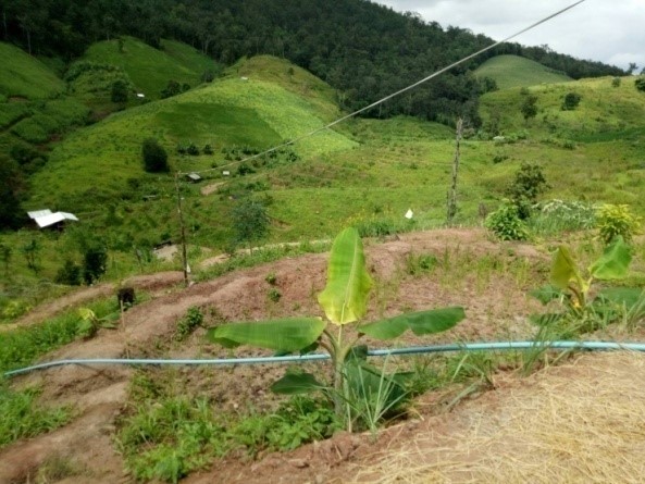
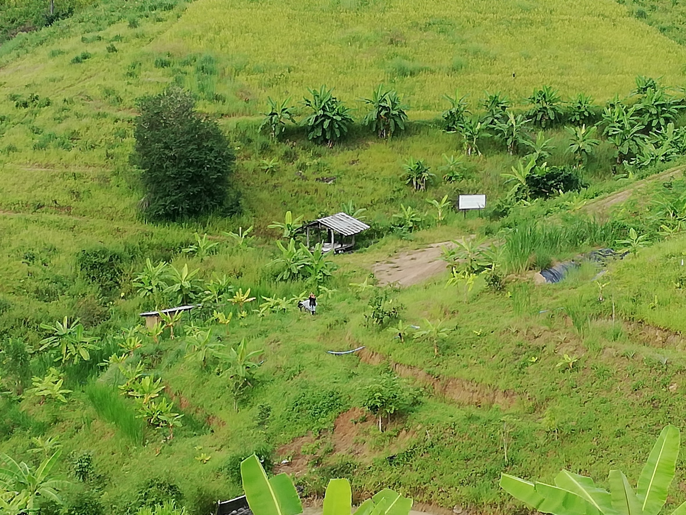
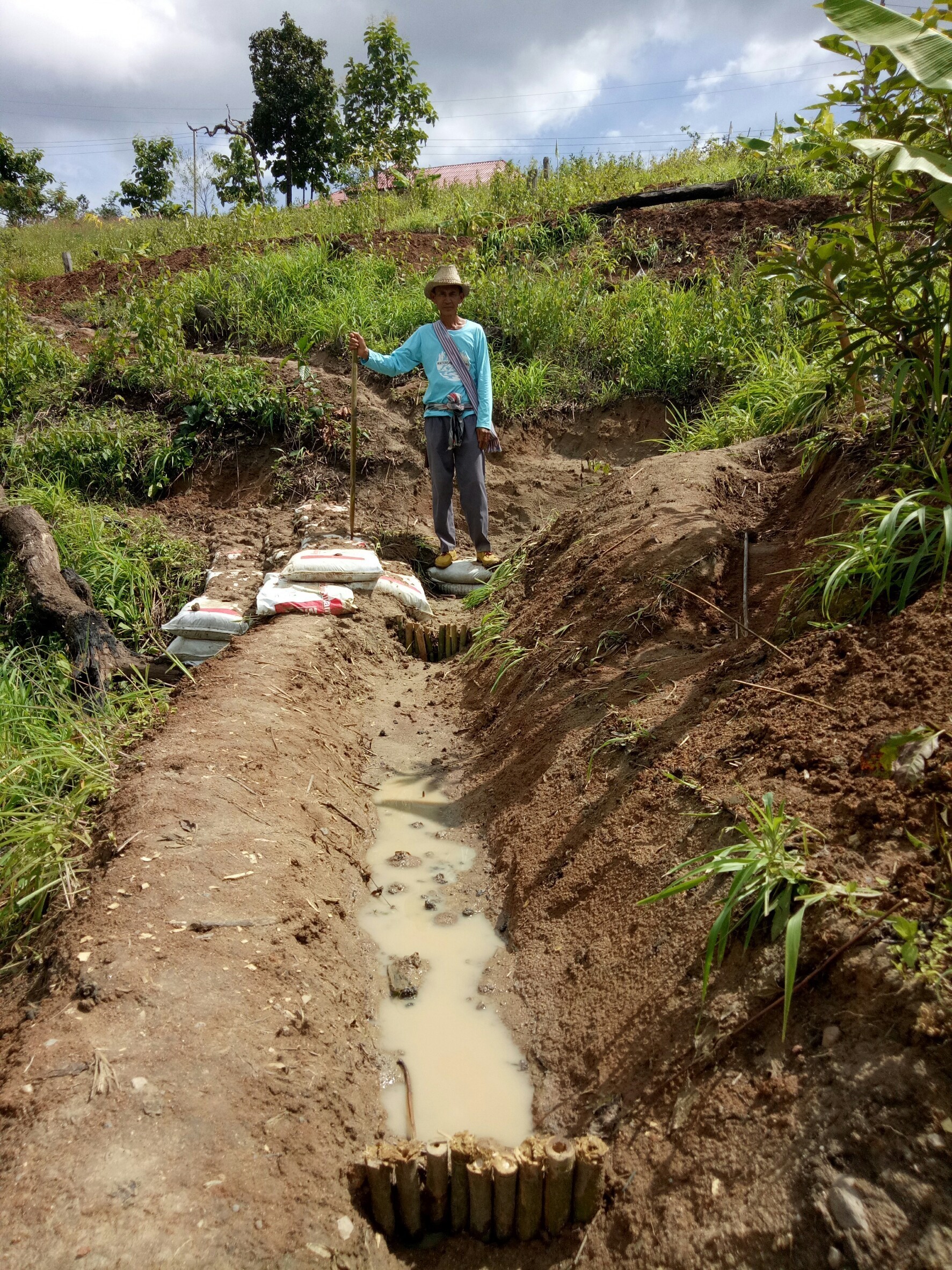
General remarks regarding photos:
คันดินที่มีแถบหญ้าแฝกปลูกขึ้นเป็นแนว ปลูกพืชอาหารและกล้วยตามคันดิน บริเวณที่ราบริมน้ำ มีการขุดบ่อเก็บกักน้ำ ปลูกไม้ผล ไม้ป่า และเลี้ยงวัวในคอก ฝั่งตรงข้ามปลูกข้าวไร่ ฟักทอง กล้วย ข้าวโพด ด้านตะวันออกปลูกผักหวานป่า และกันพื้นที่ไว้ปลูกป่าด้วย ส่วนที่เป็นนาขั้นบันไดดินสำหรับปลูกข้าว มีการห่มดินด้วยฟางข้าวหลังเก็บเกี่ยว ปลูกได้ปีละครั้ง
2.4 Videos of the Technology
Date:
12/09/2018
الموقع:
ตำบลบ้านทับ
Name of videographer:
Ms.Tanomkhaw Thipwong
2.5 Country/ region/ locations where the Technology has been applied and which are covered by this assessment
بلد:
Thailand
Region/ State/ Province:
เชียงใหม่
Further specification of location:
ตำบลบ้านทับ อำเภอแม่แจ่ม
Comments:
นายบุญมา แหลมคม
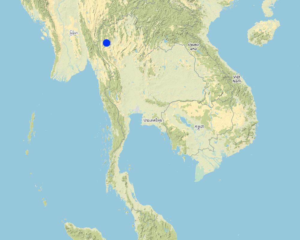
Map
×2.6 Date of implementation
Indicate year of implementation:
2006
If precise year is not known, indicate approximate date:
- 10-50 years ago
2.7 Introduction of the Technology
Specify how the Technology was introduced:
- through projects/ external interventions
Comments (type of project, etc.):
เป็นโครงการเพื่อแก้ปัญหาภัยแล้ง หมอกควันที่เกิดจากการเผาทำลายซากข้าวโพด
และบุกรุกป่าเพื่อใช้พื้นที่ทำกิน
3. Classification of the SLM Technology
3.1 Main purpose(s) of the Technology
- reduce, prevent, restore land degradation
- conserve ecosystem
- reduce risk of disasters
- create beneficial economic impact
3.2 Current land use type(s) where the Technology is applied

Mixed (crops/ grazing/ trees), incl. agroforestry
- Agro-silvopastoralism

Waterways, waterbodies, wetlands
- Drainage lines, waterways
- Ponds, dams
- Swamps, wetlands
- แท็งค์น้ำ
Main products/ services:
บ่อน้ำใหญ่ บ่อน้ำรอง หนอง ฝายชะลอน้ำ ทางระบายน้ำ(คลองไส้ไก่) และแท็งค์น้ำ สำหรับเก็บกักน้ำไว้ในหน้าแล้ง
If land use has changed due to the implementation of the Technology, indicate land use before implementation of the Technology:
Ca: การปลูกพืชล้มลุก(Annual cropping)
3.3 Further information about land use
Water supply for the land on which the Technology is applied:
- rainfed
Comments:
-
Number of growing seasons per year:
- 1
حددها:
นาน้ำฝน และไม้ผล
Livestock density (if relevant):
เลี้ยงวัวในพื้นที่ จำนวน 8 ตัว มีแปลงหญ้าเนเปียร์ใกล้กับร่องลำธาร เลี้ยงโดยการล้อมคอก
3.4 SLM group to which the Technology belongs
- agroforestry
- water harvesting
- irrigation management (incl. water supply, drainage)
3.5 Spread of the Technology
Specify the spread of the Technology:
- evenly spread over an area
If the Technology is evenly spread over an area, indicate approximate area covered:
- > 10,000 km2
Comments:
มากกว่าพื้นที่อำเภอแม่แจ่ม (2,686.571 ตร.กม.)
3.6 SLM measures comprising the Technology

agronomic measures
- A1: Vegetation/ soil cover

vegetative measures
- V2: Grasses and perennial herbaceous plants

structural measures
- S1: Terraces
- S3: Graded ditches, channels, waterways
- S4: Level ditches, pits
3.7 Main types of land degradation addressed by the Technology

chemical soil deterioration
- Cn: fertility decline and reduced organic matter content (not caused by erosion)
- Cp: soil pollution
Comments:
เกิดจากการกระทำโดยมนุษย์ เช่นการใช้ปุ๋ยเคมี สารป้องกันกำจัดโรคแมลง และสารกำจัดวัชพืช ทั้งในพื้นที่และบริเวณต้นน้ำ
3.8 Prevention, reduction, or restoration of land degradation
Specify the goal of the Technology with regard to land degradation:
- reduce land degradation
- restore/ rehabilitate severely degraded land
4. Technical specifications, implementation activities, inputs, and costs
4.1 Technical drawing of the Technology
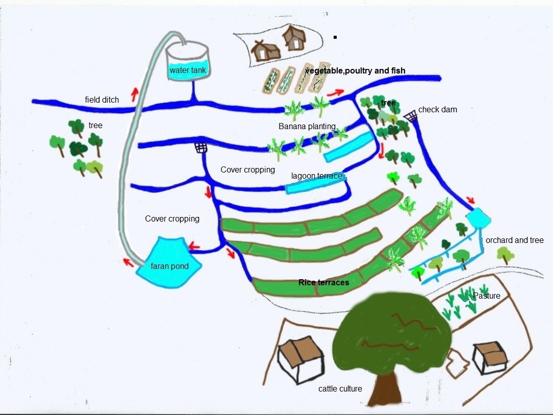
Author:
สมจิตต์ เลิศดิษยวรรณ
Date:
12/09/2018
4.2 Technical specifications/ explanations of technical drawing
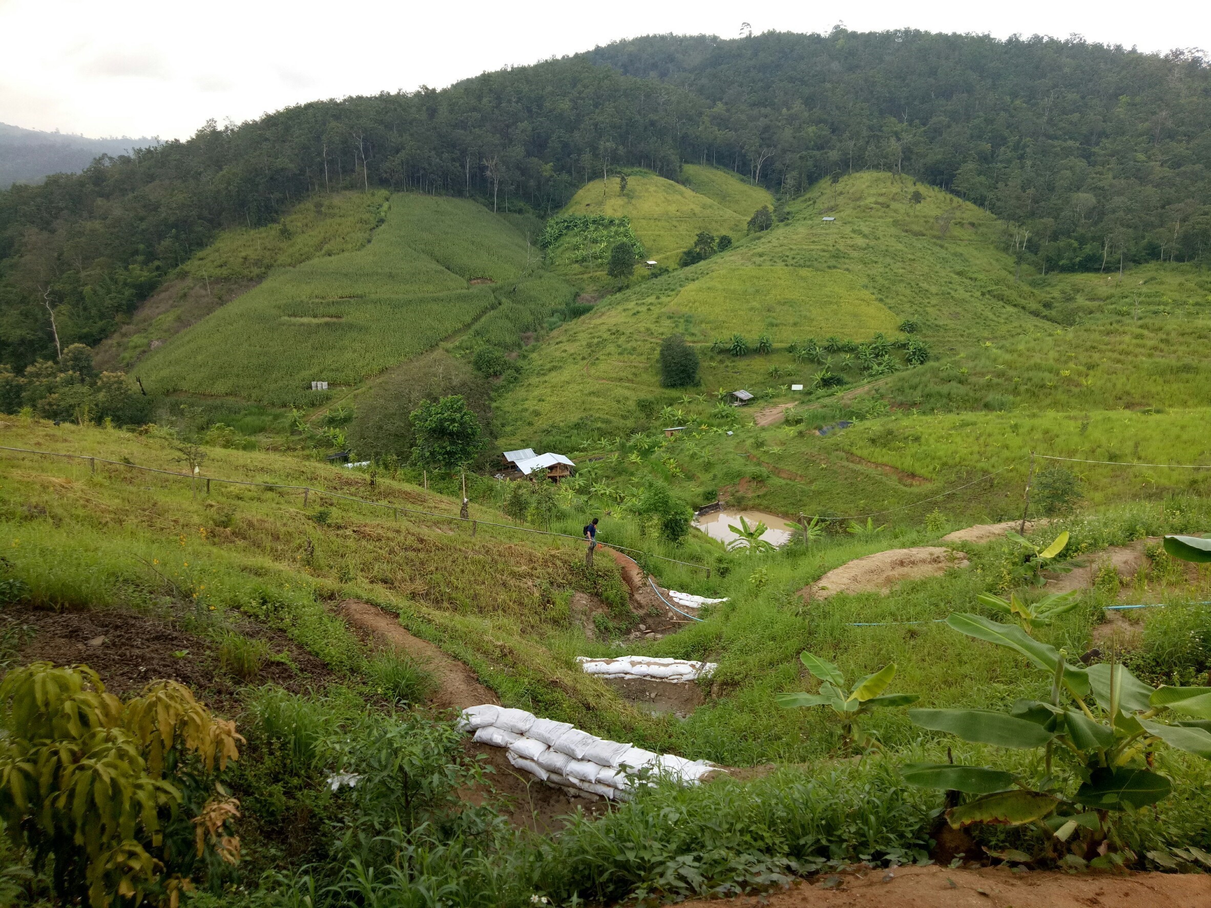
เนื่องจากเป็นพื้นที่ภูเขาสูง ความชันมากกว่า 35 % ทำการขุดบ่อเพื่อเก็บกักน้ำ โดยบ่อน้ำใหญ่ กว้าง 3 เมตร ลึก 3 เมตร และยาว 20 เมตร อยู่ที่พื้นราบด้านล่าง และขุดบ่อขั้นบันได อีก 2 บ่อ กว้าง 1 เมตร ลึก 0.7 เมตร และยาว 20 เมตรไว้ในแนวระดับ สร้างแท็งค์น้ำขนาด 20,000 ลิตรไว้ด้านบนสุด แล้วสูบน้ำจากบ่อน้ำใหญ่ขึ้นไปเก็บไว้ที่แท็งค์น้ำด้วยพลังงานแสงอาทิตย์ และปล่อยลงในคลองไส้ไก่กว้าง 0.2-0.5 เมตรซึ่งขุดลัดเลาะเข้าไปในพื้นที่และลดหลั่นตามแนวระดับลงมาให้ทั่วพื้นที่ เพื่อกระจายน้ำและความชุ่มชื้นให้แก่พืชผัก สวนครัว นา ไม้ป่าและไม้ผลที่ปลูกไว้ มีการกั้นฝายกระสอบทรายจำนวน 6 ฝายไว้ที่ร่องเขาทั้งด้าน เพื่อชะลอและเก็บกักน้ำ ยังมีการเก็บน้ำไว้ในนาขั้นบันไดอีกโดยการยกคันนาให้สูง แต่ก็ทำได้แค่ 0.3 เมตร สามารถปลูกข้าวได้ปีละครั้ง ขอบคันดินและคันนาปลูกกล้วย แฝก พืชผัก พืชสวนครัวต่างๆ ด้านล่างมีการเลี้ยววัวโดยการล้อมคอก กั้นพื้นที่บางส่วนสำหรับปลูกป่า บางส่วนปลูกไม้ผลผสมกับไม้ป่า มีการปลูกพืชคลุมดิน หรือปล่อยหญ้าคลุมดินไว้ หรือทำการห่มดินด้วยฟางข้าวหรือเศษพืชอื่นๆ เพื่อป้องกันไม่ให้ดินโดนแสงแดดโดยตรงและรักษาความชื้นในดิน ด้านบนเป็นส่วนของการเลี้ยงไก่ ปลา ปลูกผัก เพาะเห็ด สำหรับไว้เป็นอาหารเพื่อยังชีพและแจกจ่ายกันในชุมชน
4.3 General information regarding the calculation of inputs and costs
Specify how costs and inputs were calculated:
- per Technology area
Indicate size and area unit:
(25 ไร่)
If using a local area unit, indicate conversion factor to one hectare:
4 เฮกตาร์
other/ national currency (specify):
บาท
Indicate exchange rate from USD to local currency (if relevant): 1 USD =:
32,0
Indicate average wage cost of hired labour per day:
300
4.4 Establishment activities
| Activity | Type of measure | Timing | |
|---|---|---|---|
| 1. | ขุดบ่อน้ำใหญ่ บ่อน้ำขั้นบันได และนาขั้นบันได | Structural | |
| 2. | ขุดคลองไส้ไก่ | Structural | |
| 3. | ปลูกแฝกและพืชคลุมดิน | Vegetative | |
| 4. | ปลูกพืชผัก ไม้ป่า และไม้ผล | Agronomic | |
| 5. | ทำฝายชะลอน้ำเพิ่มการกักเก็บน้ำ | Structural | |
| 6. | สร้างแท็งค์น้ำ เพื่อเก็บน้ำไว้ใช้ในช่วงแล้ง | Structural |
4.5 Costs and inputs needed for establishment
| Specify input | Unit | Quantity | Costs per Unit | Total costs per input | % of costs borne by land users | |
|---|---|---|---|---|---|---|
| Labour | แรงงาน 5 คน / 4 วัน ทำโครงสร้างหลัก คันดิน คูรับน้ำ | แรง | 20,0 | 300,0 | 6000,0 | |
| Equipment | แมคโคร 1 คัน ค่าเช่ารวมน้ำมัน | วัน | 4,0 | 5450,0 | 21800,0 | 100,0 |
| Plant material | ได้จากแหล่งสนับสนุน | - | ||||
| Construction material | ฝายชะลอน้ำ (100กระสอบ/ฝาย) | กระสอบ | 600,0 | 4,0 | 2400,0 | |
| Construction material | ค่าแรงงาน | แรง | 42,0 | 300,0 | 12600,0 | |
| Other | วัสดุสร้างแท็งค์น้ำ 20,000 ลิตร | แท็งค์ | 1,0 | 8600,0 | 8600,0 | 100,0 |
| Other | ค่าแรงงาน | แรง | 147,0 | 300,0 | 44100,0 | |
| Total costs for establishment of the Technology | 95500,0 | |||||
If land user bore less than 100% of costs, indicate who covered the remaining costs:
น้อยกว่า 10 % ส่วนใหญ่กรมป่าไม้เป็นผู้รับผิดชอบ 90 %
Comments:
-
4.6 Maintenance/ recurrent activities
Comments:
ยังเป็นช่วงเริ่มการจัดตั้ง และดูแลโดยเจ้าของที่ดินเป็นหลัก และเสริมแรงงานจากการหมุนเวียนคนมาจากโครงการ "เอามื้อสามัคคี"
4.7 Costs and inputs needed for maintenance/ recurrent activities (per year)
If land user bore less than 100% of costs, indicate who covered the remaining costs:
-
Comments:
-
4.8 Most important factors affecting the costs
Describe the most determinate factors affecting the costs:
-
5. Natural and human environment
5.1 Climate
Annual rainfall
- < 250 mm
- 251-500 mm
- 501-750 mm
- 751-1,000 mm
- 1,001-1,500 mm
- 1,501-2,000 mm
- 2,001-3,000 mm
- 3,001-4,000 mm
- > 4,000 mm
Specify average annual rainfall (if known), in mm:
1370,00
Specifications/ comments on rainfall:
ความยาวของช่วงฝนแล้ง ประมาณ 2 เดือน มีนาคมและเมษายน
Indicate the name of the reference meteorological station considered:
-
Agro-climatic zone
- sub-humid
-
5.2 Topography
Slopes on average:
- flat (0-2%)
- gentle (3-5%)
- moderate (6-10%)
- rolling (11-15%)
- hilly (16-30%)
- steep (31-60%)
- very steep (>60%)
Landforms:
- plateau/plains
- ridges
- mountain slopes
- hill slopes
- footslopes
- valley floors
Altitudinal zone:
- 0-100 m a.s.l.
- 101-500 m a.s.l.
- 501-1,000 m a.s.l.
- 1,001-1,500 m a.s.l.
- 1,501-2,000 m a.s.l.
- 2,001-2,500 m a.s.l.
- 2,501-3,000 m a.s.l.
- 3,001-4,000 m a.s.l.
- > 4,000 m a.s.l.
5.3 Soils
Soil depth on average:
- very shallow (0-20 cm)
- shallow (21-50 cm)
- moderately deep (51-80 cm)
- deep (81-120 cm)
- very deep (> 120 cm)
Soil texture (topsoil):
- medium (loamy, silty)
Soil texture (> 20 cm below surface):
- medium (loamy, silty)
Topsoil organic matter:
- low (<1%)
If available, attach full soil description or specify the available information, e.g. soil type, soil PH/ acidity, Cation Exchange Capacity, nitrogen, salinity etc.
-
5.4 Water availability and quality
Ground water table:
5-50 m
Availability of surface water:
medium
Water quality (untreated):
for agricultural use only (irrigation)
Is water salinity a problem?
لا
Is flooding of the area occurring?
لا
Comments and further specifications on water quality and quantity:
-
5.5 Biodiversity
Species diversity:
- medium
Habitat diversity:
- medium
Comments and further specifications on biodiversity:
-
5.6 Characteristics of land users applying the Technology
Sedentary or nomadic:
- Sedentary
Market orientation of production system:
- subsistence (self-supply)
Off-farm income:
- > 50% of all income
Relative level of wealth:
- poor
- average
Individuals or groups:
- individual/ household
- groups/ community
Level of mechanization:
- manual work
Gender:
- women
- men
Age of land users:
- middle-aged
- elderly
Indicate other relevant characteristics of the land users:
เป็นบุคคลที่มีหนี้สินเป็นหลักแสนและมีความต้องการปลดหนี้ให้หมดไป ต้องการฟื้นคืนผืนป่าให้กลับสู่ธรรมชาติดั้งเดิม และรักษาสภาพแวดล้อมให้ดีขึ้น เพื่อให้ลูกหลานสามารถดำรงชีวิตอยู่ได้ในอนาคต มีการร่วมกลุ่มช่วยกันทำงาน แบ่งเป็น 4 กลุ่มๆละ 5-6 คน หมุนเวียนแรงงานซึ่งกันและกัน สัปดาห์ละ 2 วัน
5.7 Average area of land owned or leased by land users applying the Technology
- < 0.5 ha
- 0.5-1 ha
- 1-2 ha
- 2-5 ha
- 5-15 ha
- 15-50 ha
- 50-100 ha
- 100-500 ha
- 500-1,000 ha
- 1,000-10,000 ha
- > 10,000 ha
Is this considered small-, medium- or large-scale (referring to local context)?
- large-scale
Comments:
-
5.8 Land ownership, land use rights, and water use rights
Land ownership:
- individual, not titled
Land use rights:
- open access (unorganized)
- communal (organized)
Water use rights:
- open access (unorganized)
- communal (organized)
Comments:
-
5.9 Access to services and infrastructure
health:
- poor
- moderate
- good
education:
- poor
- moderate
- good
technical assistance:
- poor
- moderate
- good
employment (e.g. off-farm):
- poor
- moderate
- good
markets:
- poor
- moderate
- good
energy:
- poor
- moderate
- good
roads and transport:
- poor
- moderate
- good
drinking water and sanitation:
- poor
- moderate
- good
financial services:
- poor
- moderate
- good
6. Impacts and concluding statements
6.1 On-site impacts the Technology has shown
Socio-economic impacts
Water availability and quality
irrigation water availability
irrigation water quality
Income and costs
expenses on agricultural inputs
farm income
workload
Socio-cultural impacts
food security/ self-sufficiency
land use/ water rights
Ecological impacts
Water cycle/ runoff
water quantity
water quality
Soil
soil moisture
soil cover
soil compaction
soil organic matter/ below ground C
Biodiversity: vegetation, animals
Vegetation cover
biomass/ above ground C
beneficial species
pest/ disease control
Climate and disaster risk reduction
drought impacts
fire risk
6.2 Off-site impacts the Technology has shown
downstream siltation
groundwater/ river pollution
6.3 Exposure and sensitivity of the Technology to gradual climate change and climate-related extremes/ disasters (as perceived by land users)
Climate-related extremes (disasters)
Climatological disasters
| How does the Technology cope with it? | |
|---|---|
| drought | well |
Comments:
-
6.4 Cost-benefit analysis
How do the benefits compare with the establishment costs (from land users’ perspective)?
Short-term returns:
neutral/ balanced
Long-term returns:
very positive
Comments:
-
6.5 Adoption of the Technology
- 10-50%
If available, quantify (no. of households and/ or area covered):
จำนวน 21 ครัวเรือน
Of all those who have adopted the Technology, how many have did so spontaneously, i.e. without receiving any material incentives/ payments?
- 0-10%
Comments:
ครั้งแรกมี 32 ครัวเรือน แล้วก็กลับไปปลูกข้าวโพดเหมือนเดิม เหลือ 13 ครัวเรือน เพราะไม่มีแรงสนับสนุนจากทางการที่ชัดเจน และหันกลับรวมกลุ่มมาอีกครั้งเพราะไม่สามารถแก้ปัญหาทั้งหมดได้โดยเฉพาะเรื่องหนี้สิน ปัจจุบันมีทั้งหมด 21 ครัวเรือน
6.6 التكيف
Has the Technology been modified recently to adapt to changing conditions?
لا
6.7 Strengths/ advantages/ opportunities of the Technology
| Strengths/ advantages/ opportunities in the land user’s view |
|---|
| ทรัพยากรดินและน้ำดีขึ้น มีความอุดมสมบูรณ์ การจัดการดินง่ายขึ้น ปลูกอะไรก็ได้กินได้ขาย ผลผลิตดีขึ้น |
| พึ่งพาตนเองได้ ไม่พี่งสารเคมี |
| สุขภาพอนามัยดีขึ้น อาหารสะอาดปลอดภัย อากาศบริสุทธิ์ |
| สร้างเครือข่ายชุมชนที่เข้มแข็ง เกิดความสามัคคี มีการเอาแรงกัน มีกฎระเบียบชุมชนและสามารถยึดถือปฏิบัติโดยเคร่งครัด |
| Strengths/ advantages/ opportunities in the compiler’s or other key resource person’s view |
|---|
| - |
| - |
| - |
6.8 Weaknesses/ disadvantages/ risks of the Technology and ways of overcoming them
| Weaknesses/ disadvantages/ risks in the land user’s view | How can they be overcome? |
|---|---|
|
มีภาระงานมากขึ้น เพราะต้องทำงานหลายอย่างในทุกๆวัน เช่น รดน้ำ ปลูกผัก เลี้ยงวัว ตัดหญ้า หาอาหารของคนและสัตว์ เป็นต้น |
- |
| มีความแตกต่างกันด้านความคิด | ต้องใช้กฎระเบียบ หรือแนวทางของกลุ่มฯเป็นหลัก |
|
ปัจจุบันยังไม่มีรายได้เป็นตัวเงิน แต่มีกิน สามารถเก็บกินได้จากของที่ปลูก สัตว์ที่เลี้ยงไว้ และแบ่งปันกันระหว่างครัวเรือน |
ไม่มีรายได้แต่ก็ไม่มีค่าใช้จ่าย แลกเปลี่ยนแจกจ่ายกันในกลุ่ม |
| ไม่มีกรรมสิทธิในที่ดิน | อยากให้หน่วยงานของรัฐเข้ามาช่วยในการปลดหนี้ พร้อมที่จะคืนและดูแลผืนป่าให้เป็นการตอบแทน |
| อยากมีรายได้จากการปลูกป่า โดยคิดคำนวณจากคาร์บอนเครดิต ซึ่งน่าจะคิดเป็นค่าตอบแทนบ้าง เพื่อให้เกษตรกรมีรายได้ด้วย | ปัจจุบันรายได้หลักมาจากการทอผ้าตีนจกของแม่บ้าน |
| Weaknesses/ disadvantages/ risks in the compiler’s or other key resource person’s view | How can they be overcome? |
|---|---|
| - | - |
| - | - |
| - | - |
7. References and links
7.1 Methods/ sources of information
- interviews with land users
2คน
- compilation from reports and other existing documentation
-
7.3 Links to relevant information which is available online
Title/ description:
คนเปลี่ยนโลก SS4 TAPE 28 : แม่แจ่มโมเดลพลัส (9 ก.ค. 61) 1/3
URL:
https://www.youtube.com/watch?v=k7Bex9ku_qY&feature=youtu.be
Title/ description:
คนเปลี่ยนโลก SS4 TAPE 28 : แม่แจ่มโมเดลพลัส (9 ก.ค. 61) 2/3
URL:
https://www.youtube.com/watch?v=RwY01nOLVvs&feature=youtu.be
Title/ description:
คนเปลี่ยนโลก SS4 TAPE 28 : แม่แจ่มโมเดลพลัส (9 ก.ค. 61) 3/3
URL:
https://www.youtube.com/watch?v=doiZ8r6Bo9I&feature=youtu.be
Title/ description:
ภาพ 3 มิติ แสดงภูมิประเทศ บ้านสองธาร อำเภอแม่แจ่ม
URL:
https://www.youtube.com/watch?v=_36pheU-GtU&feature=youtu.be
Title/ description:
3D บ้านสองธาร อ.แม่แจ่ม
URL:
https://www.youtube.com/watch?v=xe6nY7iA0Ac&feature=youtu.be
Links and modules
Expand all Collapse allLinks
No links
Modules
No modules