Dams [Cape Verde]
- Creation:
- Update:
- Compiler: Jacques Tavares
- Editor: –
- Reviewers: Fabian Ottiger, Alexandra Gavilano
Diques de alvenaria
technologies_1571 - Cape Verde
View sections
Expand all Collapse all1. General information
1.2 Contact details of resource persons and institutions involved in the assessment and documentation of the Technology
SLM specialist:
Varela Larissa
INIDA
Cape Verde
Name of the institution(s) which facilitated the documentation/ evaluation of the Technology (if relevant)
INIDA (INIDA) - Cape Verde1.3 Conditions regarding the use of data documented through WOCAT
The compiler and key resource person(s) accept the conditions regarding the use of data documented through WOCAT:
Yes
1.4 Declaration on sustainability of the described Technology
Is the Technology described here problematic with regard to land degradation, so that it cannot be declared a sustainable land management technology?
No
1.5 Reference to Questionnaire(s) on SLM Approaches (documented using WOCAT)
Training, information and awareness raising [Cape Verde]
Integration of stakeholders in the implementation of natural resource conservation activities.
- Compiler: Jacques Tavares
2. Description of the SLM Technology
2.1 Short description of the Technology
Definition of the Technology:
Infrastructure of stone, mortar and concrete, built along the waterline, with the aim of retaining sediment dragged by water runoff.
2.2 Detailed description of the Technology
Description:
Structures of large and long-term, in which the size depends on the slope of the stream and the soil and climate of the region. His installation also depends on the hydro-geology and topography and location of financial capital for its construction. The distance between two dikes, means are set, and is calculated by the slope of the bed, and the need to submit the site for its structure. It consists of an amount of vestment, a vestment of downstream foundation, crest and wings. This technique is consolidated with techniques of correction of slopes, as barriers, such as live barriers, banquets, afforestation, and others, increasing your time of life.
The purpose of their construction is to reduce the slope of the rivers and protect the bed, reducing the kinetic energy of flood water. The promotion of agricultural production is also one of its objectives, therefore retains sediment dragged the slopes, creating new agricultural areas. Contributes to the power of water, because it facilitates the infiltration with the decrease of velocity of flow. The implementation of the dam requires several previous studies with regard to its location, safety, design and budget. The activities of this technique, the most demanding in terms of knowledge and more expensive. After this stage do not require maintenance in the infrastructure, activities can occur in soil and water conservation within the basin. The technique is carried out in regions of sub-humid, arid and semi-arid, throughout the basin, regardless of local customs and the land next focus. The land recovered by this technique are mainly agricultural use. The construction of infrastructure USA the labor fronts of high-intensity or the local associations that can show. The most direct beneficiary of this technique, the use of agricultural areas caused, the owner is close to infrastructure. In some cases the ownership of land creates conflict among users of neighboring land.
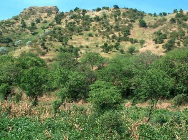
2.3 Photos of the Technology
2.5 Country/ region/ locations where the Technology has been applied and which are covered by this assessment
Country:
Cape Verde
Region/ State/ Province:
Ribeira Seca
Further specification of location:
S.Lourenço; Picos; St Cruz; S. Domingos
Specify the spread of the Technology:
- evenly spread over an area
If the Technology is evenly spread over an area, specify area covered (in km2):
71.5
Comments:
Total area covered by the SLM Technology is 71.5 km2.
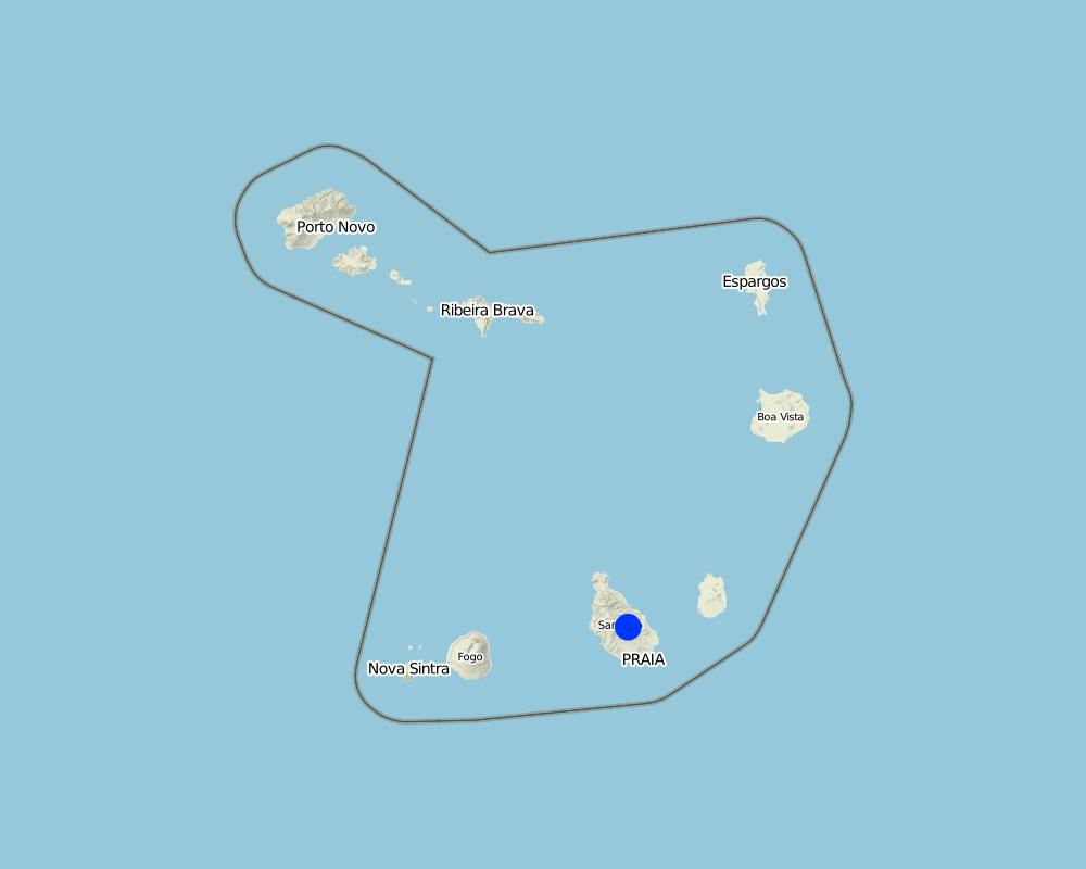
Map
×2.6 Date of implementation
If precise year is not known, indicate approximate date:
- 10-50 years ago
2.7 Introduction of the Technology
Specify how the Technology was introduced:
- through projects/ external interventions
3. Classification of the SLM Technology
3.1 Main purpose(s) of the Technology
- reduce, prevent, restore land degradation
3.2 Current land use type(s) where the Technology is applied

Cropland
- Annual cropping
Specify:
Longest growing period in days: 90, Longest growing period from month to month: Aug - Oct

Waterways, waterbodies, wetlands
- Ponds, dams
Comments:
Major land use problems (compiler’s opinion): Loss of soil by water runoff, reducing its thickness and fertility.
3.3 Has land use changed due to the implementation of the Technology?
Has land use changed due to the implementation of the Technology?
- Yes (Please fill out the questions below with regard to the land use before implementation of the Technology)
Waterways, waterbodies, wetlands
3.4 Water supply
Water supply for the land on which the Technology is applied:
- rainfed
Comments:
Water supply: Also mixed rainfed - irrigated
3.5 SLM group to which the Technology belongs
- surface water management (spring, river, lakes, sea)
3.6 SLM measures comprising the Technology

structural measures
- S5: Dams, pans, ponds
3.7 Main types of land degradation addressed by the Technology

soil erosion by water
- Wt: loss of topsoil/ surface erosion
- Wg: gully erosion/ gullying

water degradation
- Hs: change in quantity of surface water
Comments:
Main causes of degradation: soil management (Intensive use of land.), crop management (annual, perennial, tree/shrub) (Cultivation of maize in areas unsuitable.), over-exploitation of vegetation for domestic use (Cutting of trees for firewood production.), Heavy / extreme rainfall (intensity/amounts) (High-intensity rainfall), education, access to knowledge and support services
Secondary causes of degradation: deforestation / removal of natural vegetation (incl. forest fires), overgrazing, population pressure, poverty / wealth
3.8 Prevention, reduction, or restoration of land degradation
Specify the goal of the Technology with regard to land degradation:
- prevent land degradation
- reduce land degradation
4. Technical specifications, implementation activities, inputs, and costs
4.1 Technical drawing of the Technology
Technical specifications (related to technical drawing):
The unloading of the dam was scaled to a particular section of the basin Maximum Full Flow (Q) = 30 m3 / s. The height of the dike is 5 meters and the length of the discharge is 20 m and height of 90 cm.
Location: Santiago. Cape Verde
Technical knowledge required for field staff / advisors: high
Main technical functions: control of dispersed runoff: retain / trap, reduction of slope angle, increase of infiltration, increase / maintain water stored in soil, increase of groundwater level / recharge of groundwater, sediment retention / trapping, sediment harvesting
Secondary technical functions: reduction of slope length, water harvesting / increase water supply
Dam/ pan/ pond
Vertical interval between structures (m): 29
Spacing between structures (m): 70.9
Construction material (stone): Of dry stone dykes, the sparrow-hawk or mortar
Construction material (concrete): Usually used in the foundation
Construction material (other): Argamassa: Used in stone masonry of the foundation and elevation. Trace 1:4 or 1:5
Slope (which determines the spacing indicated above): 30%
Author:
Jacques Tavares
4.2 General information regarding the calculation of inputs and costs
other/ national currency (specify):
ECV
If relevant, indicate exchange rate from USD to local currency (e.g. 1 USD = 79.9 Brazilian Real): 1 USD =:
80.0
Indicate average wage cost of hired labour per day:
6.25
4.3 Establishment activities
| Activity | Timing (season) | |
|---|---|---|
| 1. | Excavation | Dry period |
| 2. | Masonry Foundation | Dry period |
| 3. | Masonry Lifting | Dry period |
4.4 Costs and inputs needed for establishment
Comments:
Duration of establishment phase: 2.8 month(s)
4.7 Most important factors affecting the costs
Describe the most determinate factors affecting the costs:
Labor (cost) access due to transport of materials, mainly cement, sand and stone
5. Natural and human environment
5.1 Climate
Annual rainfall
- < 250 mm
- 251-500 mm
- 501-750 mm
- 751-1,000 mm
- 1,001-1,500 mm
- 1,501-2,000 mm
- 2,001-3,000 mm
- 3,001-4,000 mm
- > 4,000 mm
Agro-climatic zone
- sub-humid
- semi-arid
5.2 Topography
Slopes on average:
- flat (0-2%)
- gentle (3-5%)
- moderate (6-10%)
- rolling (11-15%)
- hilly (16-30%)
- steep (31-60%)
- very steep (>60%)
Landforms:
- plateau/plains
- ridges
- mountain slopes
- hill slopes
- footslopes
- valley floors
Altitudinal zone:
- 0-100 m a.s.l.
- 101-500 m a.s.l.
- 501-1,000 m a.s.l.
- 1,001-1,500 m a.s.l.
- 1,501-2,000 m a.s.l.
- 2,001-2,500 m a.s.l.
- 2,501-3,000 m a.s.l.
- 3,001-4,000 m a.s.l.
- > 4,000 m a.s.l.
5.3 Soils
Soil depth on average:
- very shallow (0-20 cm)
- shallow (21-50 cm)
- moderately deep (51-80 cm)
- deep (81-120 cm)
- very deep (> 120 cm)
Soil texture (topsoil):
- coarse/ light (sandy)
- medium (loamy, silty)
Topsoil organic matter:
- medium (1-3%)
- low (<1%)
If available, attach full soil description or specify the available information, e.g. soil type, soil PH/ acidity, Cation Exchange Capacity, nitrogen, salinity etc.
Soil fertility: Medium
Soil drainage/infiltration: Medium (ranked 1) and good (ranked 2)
Soil water storage capacity: Low (ranked 1) and medium (ranked 2, little deep soils with high slopes)
5.4 Water availability and quality
Ground water table:
5-50 m
Availability of surface water:
medium
Water quality (untreated):
poor drinking water (treatment required)
Comments and further specifications on water quality and quantity:
Ground water table: Also > 50 m
Availability of surface water: Medium (Sources in the period of rains, but also through galleries)
Water quality (untreated): Also good drinking water (ranked 2)
5.5 Biodiversity
Species diversity:
- low
5.6 Characteristics of land users applying the Technology
Market orientation of production system:
- subsistence (self-supply)
- mixed (subsistence/ commercial)
Relative level of wealth:
- poor
- average
Level of mechanization:
- manual work
- mechanized/ motorized
Indicate other relevant characteristics of the land users:
Population density: 100-200 persons/km2
Annual population growth: > 4%; 5% (0.5).
3% of the land users are average wealthy.
80% of the land users are poor.
Market orientation: Subsistence (Many owners have not put their products on the market)
Market orientation: Manual work (ranked 1) and mechanized (ranked 2, some owners rent tractor to plow their land)
5.7 Average area of land used by land users applying the Technology
- < 0.5 ha
- 0.5-1 ha
- 1-2 ha
- 2-5 ha
- 5-15 ha
- 15-50 ha
- 50-100 ha
- 100-500 ha
- 500-1,000 ha
- 1,000-10,000 ha
- > 10,000 ha
5.8 Land ownership, land use rights, and water use rights
Land ownership:
- individual, titled
Land use rights:
- leased
- individual
Water use rights:
- communal (organized)
- individual
5.9 Access to services and infrastructure
health:
- poor
- moderate
- good
education:
- poor
- moderate
- good
technical assistance:
- poor
- moderate
- good
employment (e.g. off-farm):
- poor
- moderate
- good
markets:
- poor
- moderate
- good
energy:
- poor
- moderate
- good
roads and transport:
- poor
- moderate
- good
drinking water and sanitation:
- poor
- moderate
- good
financial services:
- poor
- moderate
- good
6. Impacts and concluding statements
6.1 On-site impacts the Technology has shown
Socio-economic impacts
Production
crop production
fodder production
risk of production failure
production area
Water availability and quality
drinking water availability
drinking water quality
water availability for livestock
water quality for livestock
irrigation water availability
irrigation water quality
Socio-cultural impacts
food security/ self-sufficiency
SLM/ land degradation knowledge
conflict mitigation
situation of socially and economically disadvantaged groups
Improved livelihoods and human well-being
Comments/ specify:
The construction of a dam can provide increased income for owners benefit, and thus improving their welfare.
Ecological impacts
Water cycle/ runoff
water quantity
water quality
harvesting/ collection of water
surface runoff
groundwater table/ aquifer
Soil
soil loss
6.2 Off-site impacts the Technology has shown
water availability
reliable and stable stream flows in dry season
downstream flooding
downstream siltation
groundwater/ river pollution
damage on neighbours' fields
6.3 Exposure and sensitivity of the Technology to gradual climate change and climate-related extremes/ disasters (as perceived by land users)
Gradual climate change
Gradual climate change
| Season | increase or decrease | How does the Technology cope with it? | |
|---|---|---|---|
| annual temperature | increase | well |
Climate-related extremes (disasters)
Meteorological disasters
| How does the Technology cope with it? | |
|---|---|
| local rainstorm | well |
| local windstorm | well |
6.7 Strengths/ advantages/ opportunities of the Technology
| Strengths/ advantages/ opportunities in the land user’s view |
|---|
| Increase in irrigable area for growing crops. |
| Increased availability of water for irrigation, for livestock and for consumption. |
| Strengths/ advantages/ opportunities in the compiler’s or other key resource person’s view |
|---|
| Reducing the slope of the bed of the streams and hence the speed of water runoff. |
| Facilitates the infiltration of rain water and hence the recharge of aquifers. |
| Correction of watercourses and protection of the margins of streams. |
| Contributes to increasing and maintaining soil humidity. |
7. References and links
7.1 Methods/ sources of information
- field visits, field surveys
- interviews with land users
7.2 References to available publications
Title, author, year, ISBN:
Field Trip Guid - DESIRE - INIDA - Cabo Verde, 2008
Available from where? Costs?
Library of INIDA
Title, author, year, ISBN:
Técnicas de Conservação de Solos e Água em Cabo Verde, MPAR & CILSS, 1994.
Available from where? Costs?
Library of CFA -INIDA
Title, author, year, ISBN:
Conservação de Solo e Água (teoria e prática), Sabino, António Advino, 1991
Available from where? Costs?
Library of CFA -INIDA
Title, author, year, ISBN:
Conservação de Solo e Água em Cabo Verde, Sabino, António Advino, 1984
Available from where? Costs?
Library of INIDA
Links and modules
Expand all Collapse allLinks
Training, information and awareness raising [Cape Verde]
Integration of stakeholders in the implementation of natural resource conservation activities.
- Compiler: Jacques Tavares
Modules
No modules