Check dam ponds [Ethiopia]
- Creation:
- Update:
- Compiler: Eyasu Yazew
- Editor: –
- Reviewers: Fabian Ottiger, Alexandra Gavilano
May me'ekori ketri
technologies_1547 - Ethiopia
View sections
Expand all Collapse all1. General information
1.2 Contact details of resource persons and institutions involved in the assessment and documentation of the Technology
SLM specialist:
SLM specialist:
Kifle Weldearegay
Mekelle University
Ethiopia
Name of the institution(s) which facilitated the documentation/ evaluation of the Technology (if relevant)
Mekelle University (Mekelle University) - Ethiopia1.3 Conditions regarding the use of data documented through WOCAT
The compiler and key resource person(s) accept the conditions regarding the use of data documented through WOCAT:
Yes
2. Description of the SLM Technology
2.1 Short description of the Technology
Definition of the Technology:
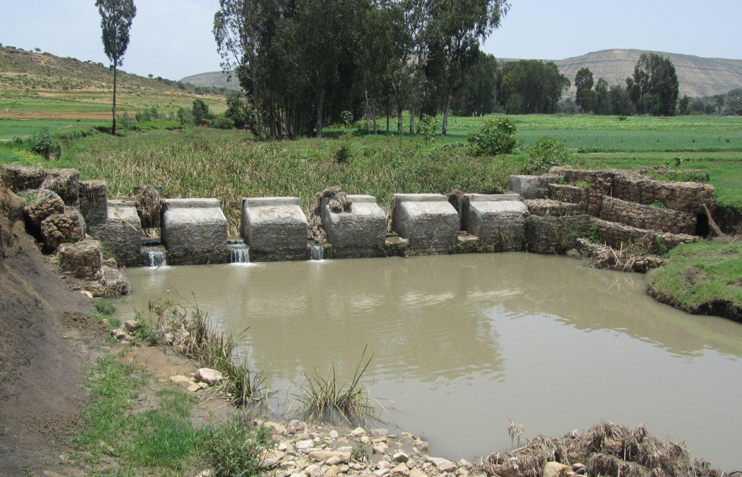
It is a raised wall constructed across a stream/gully using stone, concrete and/or gabion for dual purpose, namely, to pond/store the stream flow behind it for irrigation purpose while at the same time reducing the runoff velocity and enhancing gully rehabilitation.
2.2 Detailed description of the Technology
Description:
A check dam pond is a raised wall constructed across a gully from stone, concrete and/or gabion to store water behind it for irrigation purpose using either gravity or lifting mechanism. The structure generally consists of construction of foundation, apron, retaining wall and the checkdam. The width of the checkdam ranges between 1 - 2 m while the height varies between 1 - 2 m depending up on the gully depth. The length of the checkdam depends on the gully width. The spacing between adjacent checkdams is determined based on two factors, namely, the gradient of the river bed and the availability of potential land that can be irrigated. It is also provided with a number of sluice gates which will be removed during the main rainy season to minimize siltation.
Purpose of the Technology: In addition to storing water for irrigation, check dam ponds decrease slope length, slope angle, runoff velocity and minimize soil erosion.
Establishment / maintenance activities and inputs: Establishment of a check dam pond starts with collection and transportation of stone and sand. The construction is started by setting out the dimensions from the design on the selected site and excavating the foundation for the different parts, namely, key trench, apron and retaining wall. The check dam is then constructed using gabions filled with stones and tightly tied together with wire. Finally the superstructure is plastered using mortar to prevent the passage of water through the body. Gates of about 1 m wide are finally constructed at about 1 m interval and fitted with sluice gates. Maintenance usually involves fixing damaged gates and reinforcing gabions.
Natural / human environment: Check dam pond is implemented in gentle (2 - 5%) and moderate (5 - 8%) slopes and in medium and light soil types of at least 1 m depth. It increases water availability for irrigation and livestock consumption purposes. It also reduces runoff velocity thereby decreasing soil erosion and enhancing gully rehabilitation.
It requires skilled labour and high construction cost. As a result, it is constructed through external support. However, the number of communities seeking for external support and willing to contribute their share is at the rise. The technology minimizes greatly the risk of crop failure and improves the livelihood of the land users.
2.3 Photos of the Technology
Media Gallery

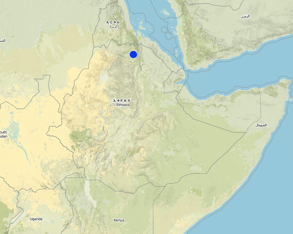
2.5 Country/ region/ locations where the Technology has been applied and which are covered by this assessment
Country:
Ethiopia
Region/ State/ Province:
Tigray
Further specification of location:
Kilite Awlaelo
Specify the spread of the Technology:
- evenly spread over an area
If precise area is not known, indicate approximate area covered:
- 1-10 km2
Map
×2.6 Date of implementation
If precise year is not known, indicate approximate date:
- less than 10 years ago (recently)
2.7 Introduction of the Technology
Specify how the Technology was introduced:
- through projects/ external interventions
3. Classification of the SLM Technology
3.2 Current land use type(s) where the Technology is applied

Cropland
- Annual cropping
Annual cropping - Specify crops:
- cereals - barley
- cereals - maize
- vegetables - root vegetables (carrots, onions, beet, other)
- tomatoes, wheat, teff
Number of growing seasons per year:
- 2
Specify:
Longest growing period in days: 150Longest growing period from month to month: June - NovemberSecond longest growing period in days: 105Second longest growing period from month to month: January - April
Comments:
Major land use problems (compiler’s opinion): Deforestation and overgrazing, high erosion risk, gully formation and land loss, decline in productivity.
Major land use problems (land users’ perception): Population pressure, deforestation, flood, soil erosion, reduced productivity.
3.4 Water supply
Water supply for the land on which the Technology is applied:
- mixed rainfed-irrigated
3.5 SLM group to which the Technology belongs
- water harvesting
- irrigation management (incl. water supply, drainage)
- surface water management (spring, river, lakes, sea)
3.6 SLM measures comprising the Technology

structural measures
- S6: Walls, barriers, palisades, fences
Comments:
Main measures: structural measures
3.7 Main types of land degradation addressed by the Technology

soil erosion by water
- Wt: loss of topsoil/ surface erosion
- Wg: gully erosion/ gullying
- Wm: mass movements/ landslides
- Wo: offsite degradation effects
Comments:
Main type of degradation addressed: Wg: gully erosion / gullying
Secondary types of degradation addressed: Wt: loss of topsoil / surface erosion, Wm: mass movements / landslides, Wo: offsite degradation effects
Main causes of degradation: deforestation / removal of natural vegetation (incl. forest fires), Heavy / extreme rainfall (intensity/amounts), other natural causes (avalanches, volcanic eruptions, mud flows, highly susceptible natural resources, extreme topography, etc.) specify (Steep topography that increases amount and velocity of flood), population pressure
Secondary causes of degradation: crop management (annual, perennial, tree/shrub), over-exploitation of vegetation for domestic use, overgrazing, floods, land tenure, poverty / wealth, education, access to knowledge and support services
3.8 Prevention, reduction, or restoration of land degradation
Specify the goal of the Technology with regard to land degradation:
- reduce land degradation
- restore/ rehabilitate severely degraded land
Comments:
Main goals: mitigation / reduction of land degradation
Secondary goals: rehabilitation / reclamation of denuded land
4. Technical specifications, implementation activities, inputs, and costs
4.1 Technical drawing of the Technology
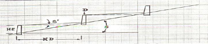
Technical specifications (related to technical drawing):
Check dam ponds are raised walls constructed across a stream/gully using stone, concrete and/or gabion for dual purpose, namely, to pond/store the stream flow behind it for irrigation purpose while at the same time reducing the runoff velocity and enhancing gully rehabilitation.
Location: Tigray. Kilte Awlaelo
Date: 10/10/2014
Technical knowledge required for field staff / advisors: high
Technical knowledge required for land users: high
Technical knowledge required for Engineer/designer: high
Main technical functions: control of dispersed runoff: impede / retard, reduction of slope length
Secondary technical functions: reduction of slope angle, increase of infiltration, increase of groundwater level / recharge of groundwater, sediment retention / trapping, sediment harvesting
Wall/ barrier
Vertical interval between structures (m): n/a
Spacing between structures (m): n/a
Height of bunds/banks/others (m): 1 - 2
Width of bunds/banks/others (m): 1 - 2
Construction material (stone): Stones are usually shaped in order to piece together very well.
Construction material (concrete): The chekdam is usually plastered by concrete on the upstream side to prevent the passage of water th
Construction material (other): Gabion, Sheet metal and Angle iron.
Slope (which determines the spacing indicated above): 2 - 8%
Lateral gradient along the structure: 0%
Author:
Eyasu Yazew, P.O.Box 231, Mekelle University, Mekelle, Ethiopia
4.2 General information regarding the calculation of inputs and costs
other/ national currency (specify):
Birr
If relevant, indicate exchange rate from USD to local currency (e.g. 1 USD = 79.9 Brazilian Real): 1 USD =:
18.0
Indicate average wage cost of hired labour per day:
2.50
4.3 Establishment activities
| Activity | Timing (season) | |
|---|---|---|
| 1. | Site clearance and excavation of foundation | Dry season |
| 2. | Stone collection and transportation | Dry season |
| 3. | Sand collection and transportation | Dry season |
| 4. | Gabion masonry work | Dry season |
| 5. | Plastering | Dry season |
4.4 Costs and inputs needed for establishment
| Specify input | Unit | Quantity | Costs per Unit | Total costs per input | % of costs borne by land users | |
|---|---|---|---|---|---|---|
| Labour | Labour | ha | 1.0 | 4678.0 | 4678.0 | 25.0 |
| Construction material | Cement | ha | 1.0 | 953.0 | 953.0 | |
| Construction material | Gabion | ha | 1.0 | 6268.0 | 6268.0 | |
| Construction material | Sheet metal | ha | 1.0 | 44.0 | 44.0 | |
| Construction material | Angle iron | ha | 1.0 | 56.0 | 56.0 | |
| Total costs for establishment of the Technology | 11999.0 | |||||
| Total costs for establishment of the Technology in USD | 666.61 | |||||
Comments:
Duration of establishment phase: 6 month(s)
4.5 Maintenance/ recurrent activities
| Activity | Timing/ frequency | |
|---|---|---|
| 1. | Fixing damaged gates and reinforcing gabions | Dry season |
4.6 Costs and inputs needed for maintenance/ recurrent activities (per year)
Comments:
Machinery/ tools: Digging hoe, shovel, hammer, crow bar
Since the check dam ponds generally vary in depth, width and most importantly in length depending up on the gully profile, calculation of cost per meter length will not be a reliable presentation. As a result, one typical check dam pond was selected and the total volume of the structure and the corresponding total cost of construction calculated. Then, the cost per cubic meter of the check dam was determined by dividing the total construction cost to the total volume of the structure.
The calculation includes the cost for the purchase of industrial materials (cement, gabion, sheet metal and angle iron) and cost of labour used for the construction including site clearance and excavation of foundation, stone and sand collection and transportation, gabion masonry work and plastering.
The price of the industrial materials and the labour wage used in the cost calculation apply to 2012. The daily labour wage for plastering is 180 Birr while it is 50 Birr for all other works.
4.7 Most important factors affecting the costs
Describe the most determinate factors affecting the costs:
Labour, availability of construction material, depth and width of gully.
5. Natural and human environment
5.1 Climate
Annual rainfall
- < 250 mm
- 251-500 mm
- 501-750 mm
- 751-1,000 mm
- 1,001-1,500 mm
- 1,501-2,000 mm
- 2,001-3,000 mm
- 3,001-4,000 mm
- > 4,000 mm
Specifications/ comments on rainfall:
Average rainfall of 450-550 mm, Main rainy season from Mid-June to August.
Agro-climatic zone
- semi-arid
Thermal climate class: subtropics
5.2 Topography
Slopes on average:
- flat (0-2%)
- gentle (3-5%)
- moderate (6-10%)
- rolling (11-15%)
- hilly (16-30%)
- steep (31-60%)
- very steep (>60%)
Landforms:
- plateau/plains
- ridges
- mountain slopes
- hill slopes
- footslopes
- valley floors
Altitudinal zone:
- 0-100 m a.s.l.
- 101-500 m a.s.l.
- 501-1,000 m a.s.l.
- 1,001-1,500 m a.s.l.
- 1,501-2,000 m a.s.l.
- 2,001-2,500 m a.s.l.
- 2,501-3,000 m a.s.l.
- 3,001-4,000 m a.s.l.
- > 4,000 m a.s.l.
5.3 Soils
Soil depth on average:
- very shallow (0-20 cm)
- shallow (21-50 cm)
- moderately deep (51-80 cm)
- deep (81-120 cm)
- very deep (> 120 cm)
Soil texture (topsoil):
- coarse/ light (sandy)
- medium (loamy, silty)
Topsoil organic matter:
- low (<1%)
If available, attach full soil description or specify the available information, e.g. soil type, soil PH/ acidity, Cation Exchange Capacity, nitrogen, salinity etc.
Soil fertility is low (medium soils, ranked 1) and very low (light soils, ranked 2)
Soil drainage/infiltration is medium (ranked 1) and good (ranked 2)
Soil water storage capacity is medium (ranked 1) and low (ranked 2)
5.4 Water availability and quality
Ground water table:
5-50 m
Availability of surface water:
good
Water quality (untreated):
for agricultural use only (irrigation)
Comments and further specifications on water quality and quantity:
Availability of surface water is good (September - January). Also medium (February-June)
5.5 Biodiversity
Species diversity:
- low
5.6 Characteristics of land users applying the Technology
Market orientation of production system:
- subsistence (self-supply)
Off-farm income:
- less than 10% of all income
Relative level of wealth:
- poor
- average
Individuals or groups:
- groups/ community
Level of mechanization:
- manual work
- animal traction
Gender:
- women
- men
Indicate other relevant characteristics of the land users:
Land users applying the Technology are mainly common / average land users
Population density: 100-200 persons/km2
Annual population growth: 2% - 3%
10% of the land users are rich and own 10% of the land.
60% of the land users are average wealthy and own 55% of the land (35 Birr/day/person).
30% of the land users are poor and own 35% of the land.
5.7 Average area of land used by land users applying the Technology
- < 0.5 ha
- 0.5-1 ha
- 1-2 ha
- 2-5 ha
- 5-15 ha
- 15-50 ha
- 50-100 ha
- 100-500 ha
- 500-1,000 ha
- 1,000-10,000 ha
- > 10,000 ha
Is this considered small-, medium- or large-scale (referring to local context)?
- small-scale
Comments:
Average land holding is 0.6 ha per household.
5.8 Land ownership, land use rights, and water use rights
Land ownership:
- state
Land use rights:
- communal (organized)
- individual
Water use rights:
- communal (organized)
5.9 Access to services and infrastructure
health:
- poor
- moderate
- good
education:
- poor
- moderate
- good
technical assistance:
- poor
- moderate
- good
employment (e.g. off-farm):
- poor
- moderate
- good
markets:
- poor
- moderate
- good
energy:
- poor
- moderate
- good
roads and transport:
- poor
- moderate
- good
drinking water and sanitation:
- poor
- moderate
- good
financial services:
- poor
- moderate
- good
Mobile communication:
- poor
- moderate
- good
6. Impacts and concluding statements
6.1 On-site impacts the Technology has shown
Socio-economic impacts
Production
crop production
risk of production failure
Water availability and quality
water availability for livestock
water quality for livestock
irrigation water availability
irrigation water quality
Income and costs
expenses on agricultural inputs
farm income
workload
Comments/ specify:
Also: Requires skilled labour
Socio-cultural impacts
food security/ self-sufficiency
health situation
Comments/ specify:
Increased investment in health care as a result of increased income.
community institutions
SLM/ land degradation knowledge
conflict mitigation
situation of socially and economically disadvantaged groups
Improved livelihoods and human well-being
Ecological impacts
Water cycle/ runoff
water quantity
harvesting/ collection of water
groundwater table/ aquifer
evaporation
Soil
soil loss
Biodiversity: vegetation, animals
plant diversity
6.2 Off-site impacts the Technology has shown
water availability
downstream flooding
downstream siltation
damage on public/ private infrastructure
6.3 Exposure and sensitivity of the Technology to gradual climate change and climate-related extremes/ disasters (as perceived by land users)
Climate-related extremes (disasters)
Hydrological disasters
| How does the Technology cope with it? | |
|---|---|
| general (river) flood | not well |
6.4 Cost-benefit analysis
How do the benefits compare with the establishment costs (from land users’ perspective)?
Short-term returns:
very positive
Long-term returns:
very positive
How do the benefits compare with the maintenance/ recurrent costs (from land users' perspective)?
Short-term returns:
very positive
Long-term returns:
very positive
6.5 Adoption of the Technology
Comments:
100% of land user families have adopted the Technology with external material support
500 land user families have adopted the Technology with external material support
There is no trend towards spontaneous adoption of the Technology
Comments on adoption trend: There is no trend for spontaneous adoption due to high costs. However, communities are increasingly seeking external support to implement this technology.
6.7 Strengths/ advantages/ opportunities of the Technology
| Strengths/ advantages/ opportunities in the land user’s view |
|---|
|
Increased water availability for irrigation and livestock consumption How can they be sustained / enhanced? Watershed management |
|
Reduced soil erosion How can they be sustained / enhanced? Construction of retaining walls |
|
Increased employment opportunity and income from irrigation How can they be sustained / enhanced? Cultivation of high value crops |
| Strengths/ advantages/ opportunities in the compiler’s or other key resource person’s view |
|---|
|
Increased water availability for irrigation as well as livestock consumption How can they be sustained / enhanced? Integrated watershed management |
|
Reduce slope length, angle and erosion risk and enhance gully rehabilitation How can they be sustained / enhanced? Regular maintenance of the structure |
6.8 Weaknesses/ disadvantages/ risks of the Technology and ways of overcoming them
| Weaknesses/ disadvantages/ risks in the compiler’s or other key resource person’s view | How can they be overcome? |
|---|---|
| High cost of construction | Selecting a site that has good availability of construction material and that can irrigate as large area as possible. |
| Require skilled labour | Training of land users |
| Labour intensive | Mass mobilization |
7. References and links
7.1 Methods/ sources of information
7.2 References to available publications
Title, author, year, ISBN:
Staff members of the Kilte Awlaelo Wereda Office of Agriculture and Rural Development and Office of Water Resources Development
Links and modules
Expand all Collapse allLinks
No links
Modules
No modules