Устойчивое землепользование территории водосборного бассейна Суой Сап [Viet Nam]
- Creation:
- Update:
- Compiler: Valeriy Demidov
- Editor: –
- Reviewer: Olga Andreeva
Водосборный бассейн Суой Сап, провинция Сон-Ла
technologies_4337 - Viet Nam
View sections
Expand all Collapse all1. General information
1.2 Contact details of resource persons and institutions involved in the assessment and documentation of the Technology
Key resource person(s)
SLM specialist:
Name of project which facilitated the documentation/ evaluation of the Technology (if relevant)
Soil and water protection (EU-SOWAP)Name of the institution(s) which facilitated the documentation/ evaluation of the Technology (if relevant)
Moscow State University (Moscow State University) - Russian Federation1.3 Conditions regarding the use of data documented through WOCAT
The compiler and key resource person(s) accept the conditions regarding the use of data documented through WOCAT:
Yes
1.4 Declaration on sustainability of the described Technology
Is the Technology described here problematic with regard to land degradation, so that it cannot be declared a sustainable land management technology?
No
2. Description of the SLM Technology
2.1 Short description of the Technology
Definition of the Technology:
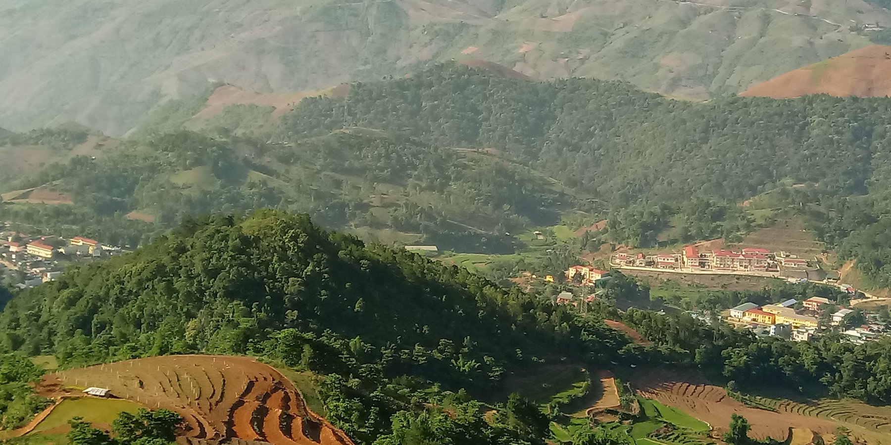
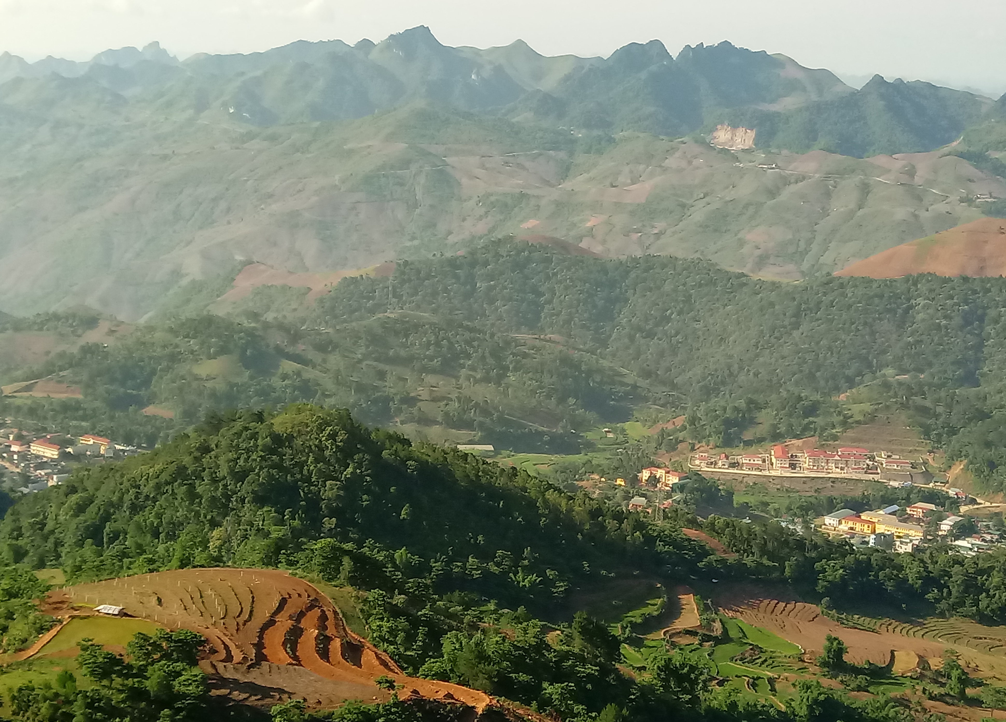
Устойчивое управление земельными ресурсами водосборного бассейна Суой Сап. Создание оптимальных условий для снижения деградационных процессов, сохранения почвенного плодородия, повышение ее роли в сельскохозяйственном и лесотехническом производствах.
2.2 Detailed description of the Technology
Description:
В последние годы особую актуальность приобретает проблема рационального использования земель в Социалистической Республике Вьетнаме. Это связано с тем, что нерациональное использование сельскохозяйственных земель приводит к снижению плодородия почв, распространению эрозионных процессов, увеличению площадей загрязненных и деградированных земель. Задача повышения эффективного использования территорий сельскохозяйственного землепользования с учетом сохранения их плодородия и экологического состояния в процессе интенсификации аграрного производства является составной частью единой государственной политики. Она направлена на обеспечение рационального использования, охрану и управление земельными ресурсами и повышение устойчивости агроэкосистем.
В связи с этим организация рационального и эффективного использования земель предусматривает создание наиболее оптимальных условий для воспроизводства и охраны почвенного плодородия в сельскохозяйственном производстве, научно-обоснованный анализ влияния природных и антропогенных факторов на состояние земельных ресурсов страны.
2.3 Photos of the Technology
Media Gallery
2.5 Country/ region/ locations where the Technology has been applied and which are covered by this assessment
Country:
Viet Nam
Region/ State/ Province:
Провинция Сон-Ла
Further specification of location:
Площадь водосборного бассейна Суой Сап составляет 26 748,7 га (267,49 км2), периметр – 77,6 км. Длина речного притока 161,7 км.
Specify the spread of the Technology:
- evenly spread over an area
If the Technology is evenly spread over an area, specify area covered (in km2):
267.49
If precise area is not known, indicate approximate area covered:
- 100-1,000 km2
Is/are the technology site(s) located in a permanently protected area?
No
Comments:
Данная территория находится в интенсивном хозяйственном использовании.
Map
×2.6 Date of implementation
Indicate year of implementation:
2018
If precise year is not known, indicate approximate date:
- less than 10 years ago (recently)
2.7 Introduction of the Technology
Specify how the Technology was introduced:
- as part of a traditional system (> 50 years)
- during experiments/ research
- through projects/ external interventions
Comments (type of project, etc.):
Технологические особенности данного проекта основываются на традиционных методах землепользования с внедрением в них современных инновационных практик рационального землепользования в связи с меняющимися арендными условиями.
3. Classification of the SLM Technology
3.1 Main purpose(s) of the Technology
- improve production
- reduce, prevent, restore land degradation
- conserve ecosystem
- protect a watershed/ downstream areas – in combination with other Technologies
- preserve/ improve biodiversity
- create beneficial economic impact
- create beneficial social impact
3.2 Current land use type(s) where the Technology is applied
Land use mixed within the same land unit:
Yes
Specify mixed land use (crops/ grazing/ trees):
- Agro-pastoralism (incl. integrated crop-livestock)

Cropland
- Annual cropping
- Perennial (non-woody) cropping
- Tree and shrub cropping
Annual cropping - Specify crops:
- cereals - maize
- cereals - rice (upland)
- cereals - rice (wetland)
- tobacco
Annual cropping system:
Maize or similar rotation with hay/pasture
Perennial (non-woody) cropping - Specify crops:
- banana/plantain/abaca
- berries
Tree and shrub cropping - Specify crops:
- coffee, open grown
Number of growing seasons per year:
- 2
Specify:
Урожай основных возделываемых культур получают за один вегетационный сезон. Только по некоторым культурам (ягодные и косточковые) собирают два урожая за сезон.
Is intercropping practiced?
No
Is crop rotation practiced?
No

Grazing land
Extensive grazing:
- Semi-nomadic pastoralism
- Ranching
Intensive grazing/ fodder production:
- Cut-and-carry/ zero grazing
Animal type:
- cattle - dairy
- cattle - non-dairy beef
- horses
- poultry
- sheep
- swine
Is integrated crop-livestock management practiced?
No
Products and services:
- meat
- milk
Species:
cattle - dairy
Count:
30000

Forest/ woodlands
- (Semi-)natural forests/ woodlands
(Semi-)natural forests/ woodlands: Specify management type:
- Selective felling
- Clear felling
- Dead wood/ prunings removal
- Non-wood forest use
Type of (semi-)natural forest:
- subtropical humid forest natural vegetation
- subtropical mountain systems natural vegetation
Type of tree:
- Bamboo bamboo
- Eucalyptus species
- Larix species (larch)
- Pinus species
Are the trees specified above deciduous or evergreen?
- mixed deciduous/ evergreen
Products and services:
- Timber
- Fuelwood
- Fruits and nuts
- Other forest products
- Grazing/ browsing
- Nature conservation/ protection
3.3 Has land use changed due to the implementation of the Technology?
Has land use changed due to the implementation of the Technology?
- Yes (Please fill out the questions below with regard to the land use before implementation of the Technology)
Land use mixed within the same land unit:
Yes
Specify mixed land use (crops/ grazing/ trees):
- Agro-pastoralism (incl. integrated crop-livestock)
Cropland
- Annual cropping
- Perennial (non-woody) cropping
- Tree and shrub cropping
Annual cropping - Specify crops:
- cereals - maize
- cereals - rice (upland)
- tobacco
- vegetables - other
Annual cropping system:
Hay
Perennial (non-woody) cropping - Specify crops:
- banana/plantain/abaca
- berries
Tree and shrub cropping - Specify crops:
- citrus
- coffee, open grown
- fruits, other
- tea
- tree nuts (brazil nuts, pistachio, walnuts, almonds, etc.)
Is intercropping practiced?
No
Is crop rotation practiced?
No
Grazing land
Extensive grazing:
- Semi-nomadic pastoralism
- Ranching
Intensive grazing/ fodder production:
- Cut-and-carry/ zero grazing
Animal type:
- cattle - dairy
- goats
- horses
- livestock - other large
- livestock - other small
- poultry
- sheep
- swine
Is integrated crop-livestock management practiced?
No
Products and services:
- eggs
- meat
- milk
- transport/ draught
Forest/ woodlands
- (Semi-)natural forests/ woodlands
- Tree plantation, afforestation
(Semi-)natural forests/ woodlands: Specify management type:
- Selective felling
- Dead wood/ prunings removal
- Non-wood forest use
Type of (semi-)natural forest:
- subtropical humid forest natural vegetation
- subtropical mountain systems natural vegetation
Tree plantation, afforestation: Specify origin and composition of species:
- Monoculture local variety
- Mixed varieties
Type of tree plantation, afforestation:
- subtropical humid forest plantation - Pinus spp.
- subtropical humid forest plantation - broadleaf
- subtropical mountain systems plantation
Type of tree:
- Acacia species
- Bamboo bamboo
- Eucalyptus species
- Pinus species (pine)
Are the trees specified above deciduous or evergreen?
- mixed deciduous/ evergreen
Products and services:
- Timber
- Fuelwood
- Fruits and nuts
- Grazing/ browsing
- Nature conservation/ protection
- Recreation/ tourism
3.4 Water supply
Water supply for the land on which the Technology is applied:
- mixed rainfed-irrigated
3.5 SLM group to which the Technology belongs
- agroforestry
- integrated crop-livestock management
- cross-slope measure
3.6 SLM measures comprising the Technology

agronomic measures
- A1: Vegetation/ soil cover
- A2: Organic matter/ soil fertility
- A3: Soil surface treatment
- A5: Seed management, improved varieties
A3: Differentiate tillage systems:
A 3.2: Reduced tillage (> 30% soil cover)

vegetative measures
- V1: Tree and shrub cover
- V2: Grasses and perennial herbaceous plants
- V4: Replacement or removal of alien/ invasive species

structural measures
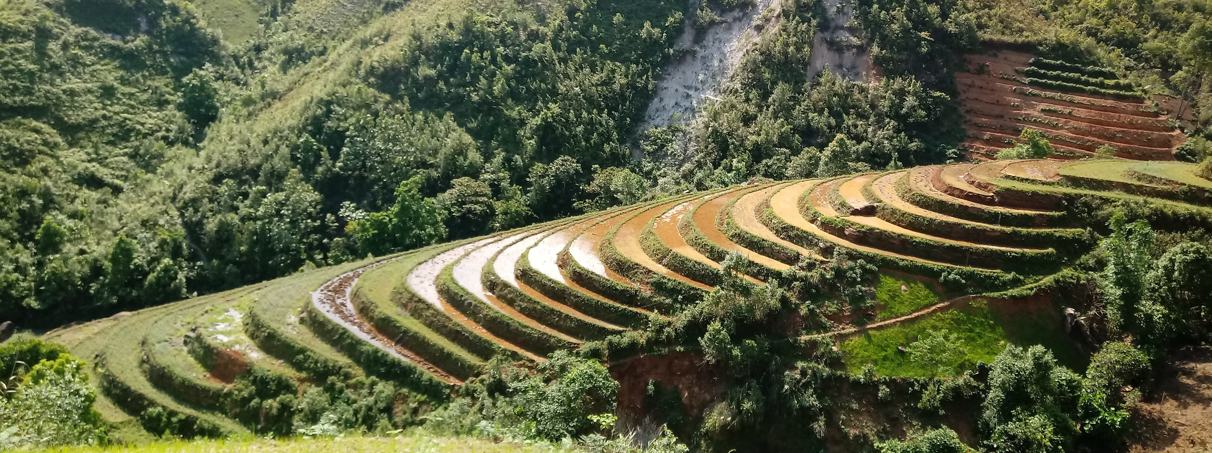
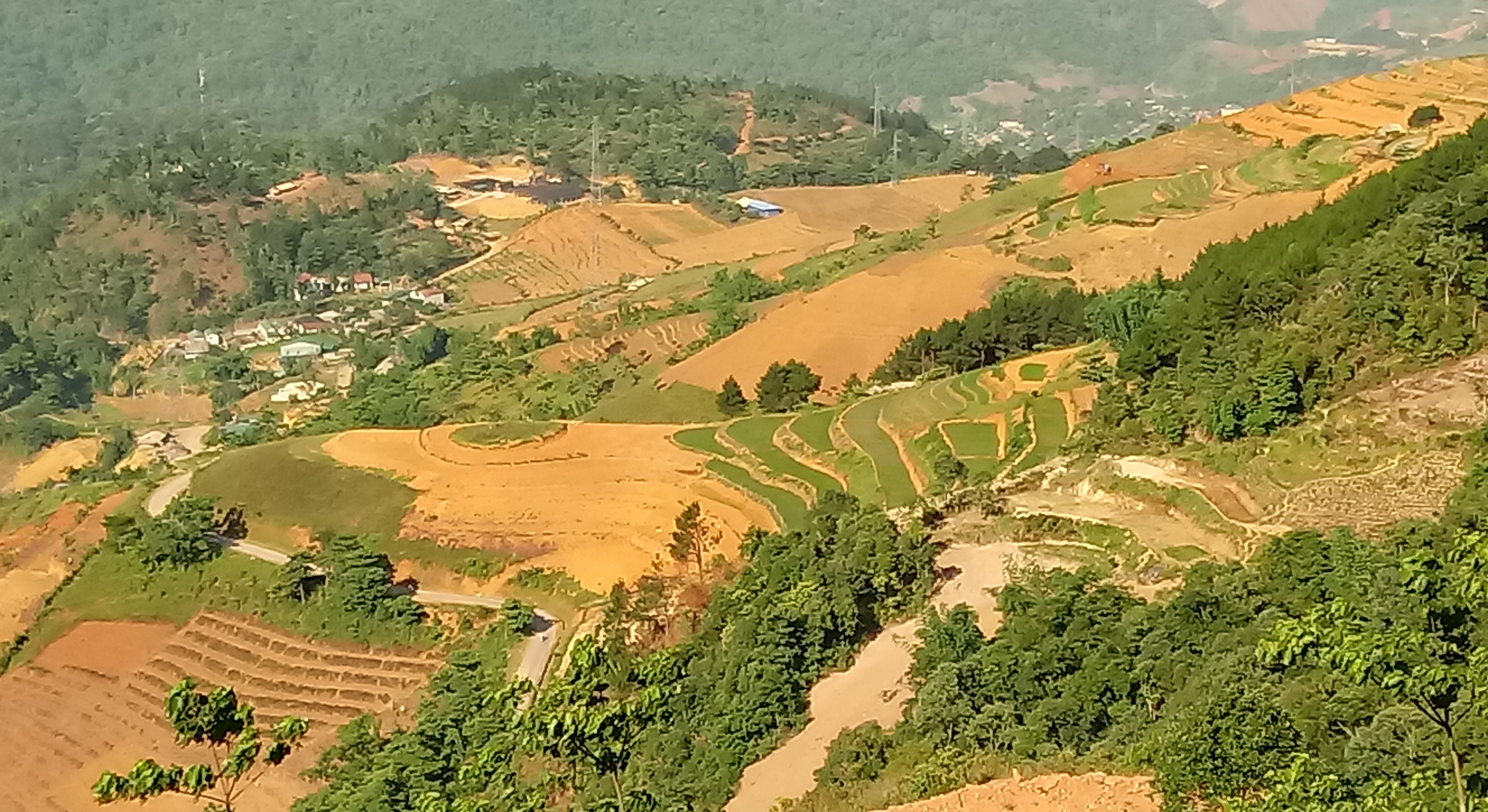
- S1: Terraces
- S2: Bunds, banks
- S3: Graded ditches, channels, waterways
- S4: Level ditches, pits
- S7: Water harvesting/ supply/ irrigation equipment
- S9: Shelters for plants and animals
- S10: Energy saving measures

management measures
- M1: Change of land use type
- M2: Change of management/ intensity level
- M3: Layout according to natural and human environment
- M5: Control/ change of species composition
3.7 Main types of land degradation addressed by the Technology

soil erosion by water
- Wt: loss of topsoil/ surface erosion
- Wg: gully erosion/ gullying
- Wm: mass movements/ landslides
- Wr: riverbank erosion
- Wo: offsite degradation effects

chemical soil deterioration
- Cn: fertility decline and reduced organic matter content (not caused by erosion)
- Ca: acidification
- Cp: soil pollution

physical soil deterioration
- Pc: compaction
- Pk: slaking and crusting
- Pu: loss of bio-productive function due to other activities

biological degradation
- Bc: reduction of vegetation cover
- Bh: loss of habitats
- Bq: quantity/ biomass decline
- Bf: detrimental effects of fires
- Bl: loss of soil life
- Bp: increase of pests/ diseases, loss of predators

water degradation
- Hs: change in quantity of surface water
- Hg: change in groundwater/aquifer level
- Hp: decline of surface water quality
- Hq: decline of groundwater quality
3.8 Prevention, reduction, or restoration of land degradation
Specify the goal of the Technology with regard to land degradation:
- reduce land degradation
- restore/ rehabilitate severely degraded land
4. Technical specifications, implementation activities, inputs, and costs
4.1 Technical drawing of the Technology
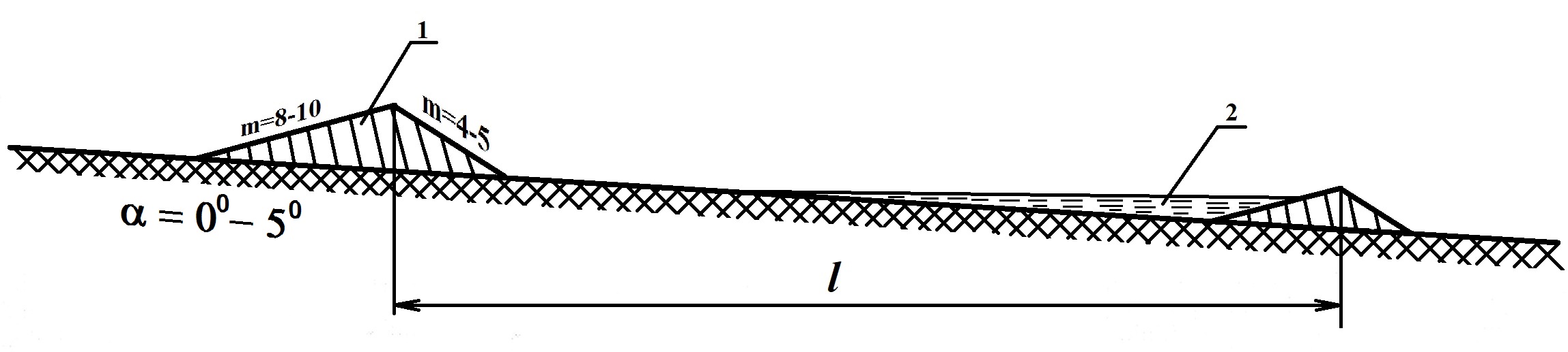
Technical specifications (related to technical drawing):
На склонах крутизной до 5 градусов при невысокой их ложбинности эффективным противоэрозионным приемом является создание варов-террас с широким основанием. Валы-террасы создаются по горизонталям местности. Концы валов заворачиваю вверх по склон под углом 120 градусов. Высота валов обычно 0,3-0,6 м. Ширина основания в 10-12 раз больше высоты. Благодаря пологим склонам на территории с валами-террасами возможно применение механизированной обработки почвы и ухода за растениями. Расстояние между валами рассчитывается на сток 10% обеспеченности. Допустимое расстояние l (по условию непереполняемости прудка) рассчитывается по следующей зависимости:
l<h2raT/2I,
где l – расстояние между валами, м; h-рабочая высота вала, м; r- интенсивность осадков, м/с; a -коэффициент стока; T – время выпадения осадков, с; I – тангенс угла наклона склона.
Условные обозначения на рисунке: 1- вал; 2- прудок.
Author:
Демидов В.В.
Date:
20/05/2019
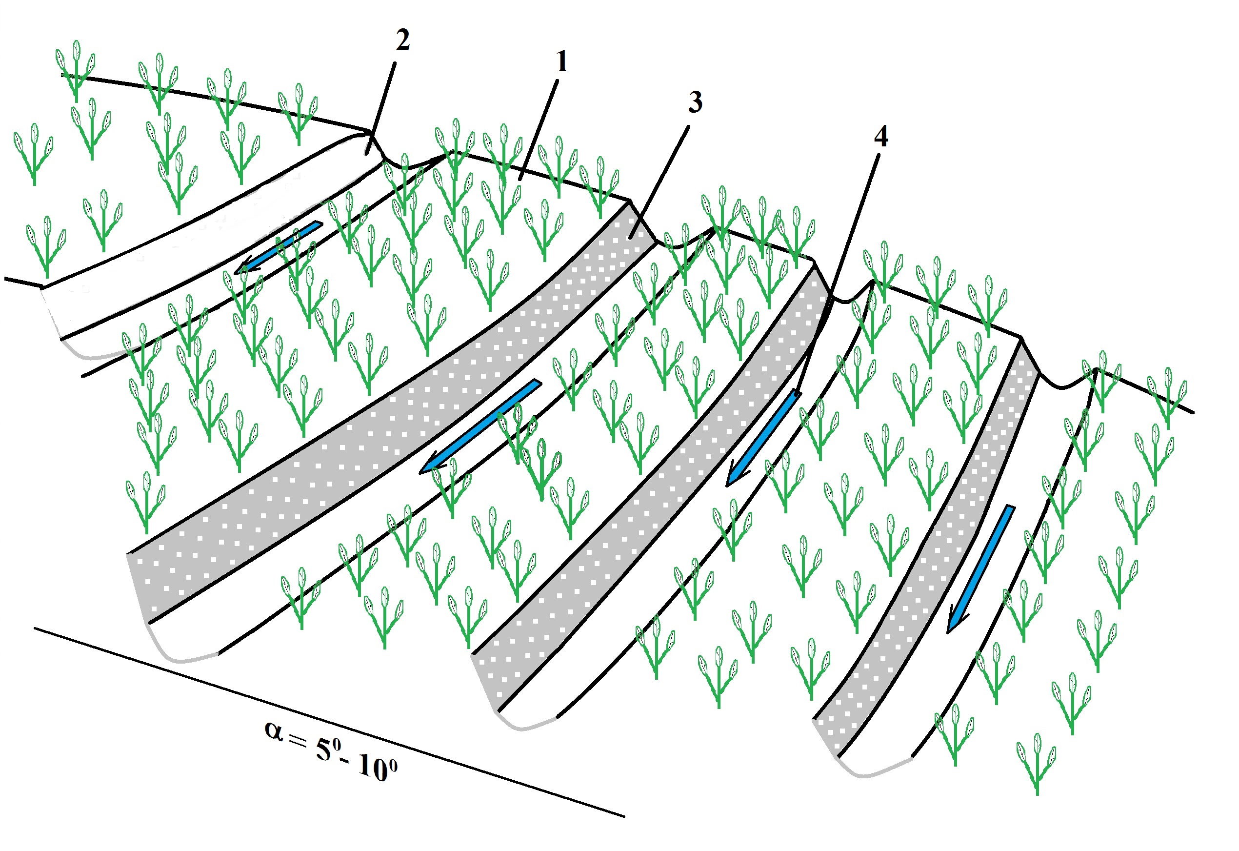
Technical specifications (related to technical drawing):
На склонах крутизной до 10 градусов эффективным мероприятием является создание ступенчатых террас. Эти террасы сооружаются с целью использования склонов для выращивания ценных многолетних и однолетних культур с применением механизированной обработки почвы и ухода за растениями. Механизм противоэрозионной эффективности такого террасирования основан на уменьшении скорости движения воды по склону. Ступенчатые террасы состоят из полотна (1), выемочного (2) и насыпного (3) откосов. В районах избыточного увлажнения целесообразно вдоль выемочного откоса прокладывать канаву (4) для отвода избытка воды. Уклон по длине канавы в сторону залуженного (или каменистого) водосброса должен быть не более 0,005. Террасы создаются в направлении горизонталей. На склонах с каменистыми почвами целесообразно сооружение вертикальных откосов террас с каменной кладкой и посевом на них многолетних трав или ягодных кустарников.
Author:
Демидов В.В.
Date:
20/05/2019
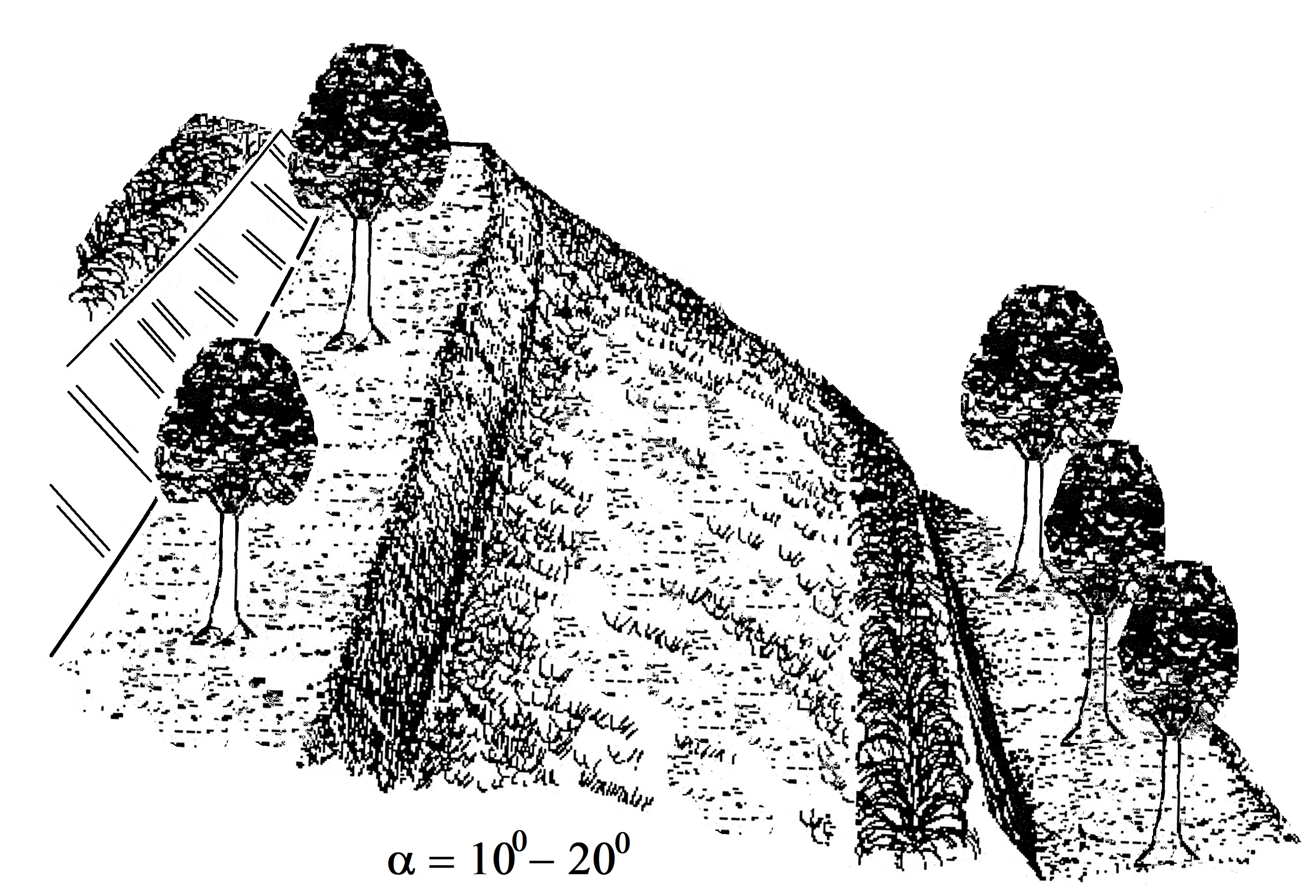
Technical specifications (related to technical drawing):
Создание террас на более крутых склонах направлено на хозяйственное использование этих земель. Учитывая то обстоятельство, что на этих склонах затруднено использование техники для создания террас, необходимо предусматривать ручной труд. Механизм противоэрозионной эффективности этих террас аналогичен террасам, описанным на склонах меньшей крутизны (см. предыдущий вариант). Эти террасы также состоят из следующих элементов: полотно (с прямым или обратным уклоном), выемочный и насыпной откосы. Террасы с прямым уклоном (4-6 градусов) экономически наиболее выгодны. При их сооружении требуется выполнения меньшего объема земляных работ. Террасы представляют собой вытянутые по горизонтали (допускается уклон вдоль полотна не более 0,003-0,005) площадки различной ширины. При уклоне 8-10 градусов ширина полотна террасы обычно составляет 6-8 м, при 10-15 градусах – 4-6 м, при уклоне 15-20 градусов – 3-4 м. В зависимости от ширины полотна террасы ее использую для выращивания цитрусовых (мандарины, лимоны, грейпфруты и др.) или для чайных плантаций. На территориях, где гумусовый горизонт имеет небольшую мощность и подстилается каменистой основой, вертикальные откосы можно формировать в виде каменистой кладки. Это обеспечивает большую полезную площадь полотна террасы и снижает риск эрозионного размыва. Для закрепления откосов террасы их рекомендуется засевать многолетними травами или ягодными кустарниками.
Author:
Демидов В.В.
Date:
20/05/2019
4.2 General information regarding the calculation of inputs and costs
Specify how costs and inputs were calculated:
- per Technology area
Indicate size and area unit:
5349 га
Specify currency used for cost calculations:
- USD
If relevant, indicate exchange rate from USD to local currency (e.g. 1 USD = 79.9 Brazilian Real): 1 USD =:
23375.72
Indicate average wage cost of hired labour per day:
8,3
4.3 Establishment activities
| Activity | Timing (season) | |
|---|---|---|
| 1. | Строительство валов-терраc c широким основанием | весна (апрель-май) |
| 2. | Террасирование склонов крутизной до 10 градусов | весна (апрель-май) |
| 3. | Создание террас на склонах крутизной до 20 градусов и более | весна (апрель-май) |
4.4 Costs and inputs needed for establishment
| Specify input | Unit | Quantity | Costs per Unit | Total costs per input | % of costs borne by land users | |
|---|---|---|---|---|---|---|
| Labour | Строительстве валов-террас с широким основанием проводится с использованием грейдеров или бульдозеров | Трактористы | 10.0 | 50.0 | 500.0 | 10.0 |
| Labour | Создание ступенчатых террас на склонах до 10 градусов | Трактористы -бульдозеристы | 15.0 | 50.0 | 750.0 | 30.0 |
| Labour | Террасирование склонов с крутизной до 20 градусов | Наемные рабочии | 100.0 | 10.0 | 1000.0 | 10.0 |
| Equipment | Трактора, бульдозеры | 10 | 10.0 | 50.0 | 500.0 | 10.0 |
| Equipment | Трактора, плантажные плуги | 5 | 15.0 | 50.0 | 750.0 | 30.0 |
| Equipment | Наемные рабочие | 50 | 100.0 | 10.0 | 1000.0 | 10.0 |
| Plant material | Семена растений | None | 36000.0 | 0.7 | 25200.0 | 20.0 |
| Plant material | Древесные и кустарниковые растения | None | 222642.0 | 0.07 | 15584.94 | 40.0 |
| Plant material | Многолетние травянистые растения | None | 237600.0 | 1.7 | 403920.0 | 15.0 |
| Fertilizers and biocides | None | None | 72000.0 | 0.11 | 7920.0 | |
| Construction material | При создании откосов террас используются камни горных пород | None | 335.0 | |||
| Total costs for establishment of the Technology | 457124.94 | |||||
| Total costs for establishment of the Technology in USD | 19.56 | |||||
If you are unable to break down the costs in the table above, give an estimation of the total costs of establishing the Technology:
457124.94
4.6 Costs and inputs needed for maintenance/ recurrent activities (per year)
| Specify input | Unit | Quantity | Costs per Unit | Total costs per input | % of costs borne by land users | |
|---|---|---|---|---|---|---|
| Labour | None | None | 2.0 | 50.0 | 100.0 | 10.0 |
| Labour | None | None | 50.0 | 8.3 | 415.0 | 100.0 |
| Labour | None | None | 100.0 | 8.3 | 830.0 | 100.0 |
| Labour | None | None | 20.0 | 8.3 | 166.0 | 100.0 |
| Equipment | None | None | 2.0 | 50.0 | 100.0 | |
| Fertilizers and biocides | None | None | 24000.0 | 0.11 | 2640.0 | |
| Total costs for maintenance of the Technology | 4251.0 | |||||
| Total costs for maintenance of the Technology in USD | 0.18 | |||||
If you are unable to break down the costs in the table above, give an estimation of the total costs of maintaining the Technology:
4251.0
5. Natural and human environment
5.1 Climate
Annual rainfall
- < 250 mm
- 251-500 mm
- 501-750 mm
- 751-1,000 mm
- 1,001-1,500 mm
- 1,501-2,000 mm
- 2,001-3,000 mm
- 3,001-4,000 mm
- > 4,000 mm
Specify average annual rainfall (if known), in mm:
1752.00
Specifications/ comments on rainfall:
Climate data on the catchment area of Soui Sap
(The average data of meteorological stations Bac Yen and Phu Yen)
MonthTemperature (оС) Rainfall (mm) Humidity (%) Evaporation (mm) Number of rainy days (n)
1 15,5 39,4 81,2 68,0 4,9
2 17,6 28,9 79,9 76,1 4,5
3 20,4 54,5 80,0 92,4 7,0
4 24,0 129,9 79,1 103,8 11,7
5 26,1 231,7 78,3 113,4 15,7
6 27,2 248,5 80,1 102,2 15,6
7 26,8 320,9 82,9 85,3 19,5
8 26,3 307,6 84,6 67,8 19,1
9 25,2 222,3 83,6 69,4 13,4
10 23,3 113,0 81,6 76,7 9,2
11 20,1 27,9 79,3 81,4 5,5
12 16,5 27,1 79,1 75,4 4,3
Indicate the name of the reference meteorological station considered:
Метеорологические данные получены на метеостанциях Бак Йен и Фу Йен
Agro-climatic zone
- humid
- sub-humid
Наибольшее количество осадков, выпадающих в виде дождей, приходится на май-сентябрь (от 222 до 320 мм в месяц)
5.2 Topography
Slopes on average:
- flat (0-2%)
- gentle (3-5%)
- moderate (6-10%)
- rolling (11-15%)
- hilly (16-30%)
- steep (31-60%)
- very steep (>60%)
Landforms:
- plateau/plains
- ridges
- mountain slopes
- hill slopes
- footslopes
- valley floors
Altitudinal zone:
- 0-100 m a.s.l.
- 101-500 m a.s.l.
- 501-1,000 m a.s.l.
- 1,001-1,500 m a.s.l.
- 1,501-2,000 m a.s.l.
- 2,001-2,500 m a.s.l.
- 2,501-3,000 m a.s.l.
- 3,001-4,000 m a.s.l.
- > 4,000 m a.s.l.
Indicate if the Technology is specifically applied in:
- convex situations
Comments and further specifications on topography:
Distribution of the catchment area by height and steepness of the slopes.
DEM class DEM (m) Area Slope class Steepness (degree) Area
ha % ha %
1 0-500 903,9 3,4 1 0-10 2007,5 7,5
2 500-1000 6665,2 24,9 2 10-20 8131,5 30,4
3 1000-1500 10013,9 37,4 3 20-30 11337,4 42,4
4 1500-2000 6780,8 25,4 4 30-40 4621,3 17,3
5 2000-2500 2250,7 8,4 5 >40 648,0 2,4
6 >2500 131,2 0,5 Total 26745,8 100,0
Total 26745,8 100,0
Note: DEM is digital elevation model.
5.3 Soils
Soil depth on average:
- very shallow (0-20 cm)
- shallow (21-50 cm)
- moderately deep (51-80 cm)
- deep (81-120 cm)
- very deep (> 120 cm)
Soil texture (topsoil):
- medium (loamy, silty)
- fine/ heavy (clay)
Soil texture (> 20 cm below surface):
- coarse/ light (sandy)
- medium (loamy, silty)
Topsoil organic matter:
- high (>3%)
If available, attach full soil description or specify the available information, e.g. soil type, soil PH/ acidity, Cation Exchange Capacity, nitrogen, salinity etc.
Area and soil types of the Suoi Sap catchment area.
FID Depth (cm)Unit codeArea (ha) Soil type groups
0 91 Ha 4504,1 Humic Acrisols/Humic Ferasols
1 93 A 1077,3 Podzoluvisols/Dystric Podzoluvisols
2 87 Hk 1460,3 Humic Acrisols/Humic Ferasols
3 93 A 546,4 Podzoluvisols/Dystric Podzoluvisols
4 0 River 15,2 River
5 93 A 3227,7 Podzoluvisols/Dystric Podzoluvisols
6 81 Fs 3942,8 Ferralsols/Ferralic Acrisols
7 90 Hs 1077,7 Humic Acrisols/Humic Ferasols
8 91 Ha 5348,7 Humic Acrisols/Humic Ferasols
9 90 Hs 1470,4 Humic Acrisols/Humic Ferasols
10 91 Ha 265,2 Humic Acrisols/Humic Ferasols
11 91 Ha 647,7 Humic Acrisols/Humic Ferasols
12 93 A 26,5 Podzoluvisols/Dystric Podzoluvisols
13 90 Hs 900,4 Humic Acrisols/Humic Ferasols
14 81 Fs 762,3 Ferralsols/Ferralic Acrisols
15 81 Fs 568,3 Ferralsols/Ferralic Acrisols
16 81 Fs 317,1 Ferralsols/Ferralic Acrisols
17 75 Fk 544,0 Ferralsols/Ferralic Acrisols
18 96 D 1,2 Dystric Gleysols
19 87 Hk 43,1 Humic Acrisols/Humic Ferasols
Total 26746,4
Note: FID is digital elevation models.
5.4 Water availability and quality
Ground water table:
5-50 m
Availability of surface water:
excess
Water quality (untreated):
poor drinking water (treatment required)
Water quality refers to:
surface water
Is water salinity a problem?
No
Is flooding of the area occurring?
Yes
Regularity:
frequently
5.5 Biodiversity
Species diversity:
- medium
Habitat diversity:
- medium
5.6 Characteristics of land users applying the Technology
Sedentary or nomadic:
- Sedentary
Market orientation of production system:
- mixed (subsistence/ commercial)
Off-farm income:
- 10-50% of all income
Relative level of wealth:
- average
Individuals or groups:
- groups/ community
- cooperative
Level of mechanization:
- manual work
- animal traction
Gender:
- women
- men
Age of land users:
- middle-aged
- elderly
5.7 Average area of land used by land users applying the Technology
- < 0.5 ha
- 0.5-1 ha
- 1-2 ha
- 2-5 ha
- 5-15 ha
- 15-50 ha
- 50-100 ha
- 100-500 ha
- 500-1,000 ha
- 1,000-10,000 ha
- > 10,000 ha
Is this considered small-, medium- or large-scale (referring to local context)?
- small-scale
- medium-scale
5.8 Land ownership, land use rights, and water use rights
Land ownership:
- state
- individual, not titled
Land use rights:
- leased
- individual
Water use rights:
- individual
Are land use rights based on a traditional legal system?
Yes
5.9 Access to services and infrastructure
health:
- poor
- moderate
- good
education:
- poor
- moderate
- good
technical assistance:
- poor
- moderate
- good
employment (e.g. off-farm):
- poor
- moderate
- good
markets:
- poor
- moderate
- good
energy:
- poor
- moderate
- good
roads and transport:
- poor
- moderate
- good
drinking water and sanitation:
- poor
- moderate
- good
financial services:
- poor
- moderate
- good
6. Impacts and concluding statements
6.3 Exposure and sensitivity of the Technology to gradual climate change and climate-related extremes/ disasters (as perceived by land users)
Gradual climate change
Gradual climate change
| Season | increase or decrease | How does the Technology cope with it? | |
|---|---|---|---|
| annual temperature | decrease | not known | |
| seasonal temperature | wet/ rainy season | decrease | moderately |
| annual rainfall | increase | not known | |
| seasonal rainfall | wet/ rainy season | decrease | moderately |
Climate-related extremes (disasters)
Meteorological disasters
| How does the Technology cope with it? | |
|---|---|
| tropical storm | not known |
| extra-tropical cyclone | not known |
| local rainstorm | moderately |
| local thunderstorm | not known |
| local hailstorm | not known |
| local snowstorm | not known |
| local sandstorm/ duststorm | not known |
| local windstorm | not known |
| tornado | not known |
Climatological disasters
| How does the Technology cope with it? | |
|---|---|
| heatwave | moderately |
| cold wave | not known |
| extreme winter conditions | moderately |
| drought | well |
| forest fire | moderately |
| land fire | not known |
Hydrological disasters
| How does the Technology cope with it? | |
|---|---|
| general (river) flood | moderately |
| flash flood | moderately |
| storm surge/ coastal flood | not known |
| landslide | moderately |
| avalanche | not known |
Biological disasters
| How does the Technology cope with it? | |
|---|---|
| epidemic diseases | not known |
| insect/ worm infestation | not known |
Other climate-related consequences
Other climate-related consequences
| How does the Technology cope with it? | |
|---|---|
| extended growing period | moderately |
| reduced growing period | not known |
| sea level rise | not known |
6.4 Cost-benefit analysis
How do the benefits compare with the establishment costs (from land users’ perspective)?
Short-term returns:
slightly positive
Long-term returns:
positive
How do the benefits compare with the maintenance/ recurrent costs (from land users' perspective)?
Short-term returns:
slightly positive
Long-term returns:
positive
6.5 Adoption of the Technology
- single cases/ experimental
Of all those who have adopted the Technology, how many did so spontaneously, i.e. without receiving any material incentives/ payments?
- 0-10%
6.6 Adaptation
Has the Technology been modified recently to adapt to changing conditions?
No
7. References and links
7.1 Methods/ sources of information
- field visits, field surveys
- interviews with land users
- compilation from reports and other existing documentation
When were the data compiled (in the field)?
17/05/2018
Comments:
Работы по проекту выполнялись в рамках «Научно-техническое сотрудничество Россия – АСЕАН по разработке и применению инновационных технологий земледелия с целью повышения устойчивости агроэкологических систем» по теме: «Исследование эрозии почв и опустынивания в целях охраны почв и устойчивого использования почвенных ресурсов» [Номер гос. регистрации в ЦИТИС: AAAA-A16-116011910278-7], проводимых в рамках Контракта № 35 Россия-АСЕАН
Links and modules
Expand all Collapse allLinks
No links
Modules
No modules